
What is Prominence and Why is it Important?
It is often assumed that elevation (i.e height above sea level) is the most important criteria for identifying a mountain that is worth climbing – the thinking behind this idea is that “a big mountain is a good mountain”. Most of the time, this thinking does turn out to be correct. However, an alternative and increasingly popular approach is to assess the extent to which a mountain qualifies as a separate peak from its neighbouring mountains – its prominence. Similar to a number of hill and mountains lists worldwide, Gunung Bagging uses topographic prominence as the objective criteria with which to identify separate mountain or volcano peaks in Indonesia.
Gunung Gede – not a Ribu or a Spesial
The following example will hopefully illustrate the difference between elevation and prominence. People may wonder why Gunung Gede does not feature in the list of Ribus. Gunung Gede is 2,962 metres above sea level (elevation) and lots of people climb it. However, nearby Gunung Pangrango is 3,020 metres in elevation. The lowest point on the ridge connecting the two peaks (also known as col, pass, or saddle) is approximately 2,520 metres. Gede elevation (2,962) minus col (2,520) equals roughly 442 metres prominence, which means that Gede is not a Ribu.
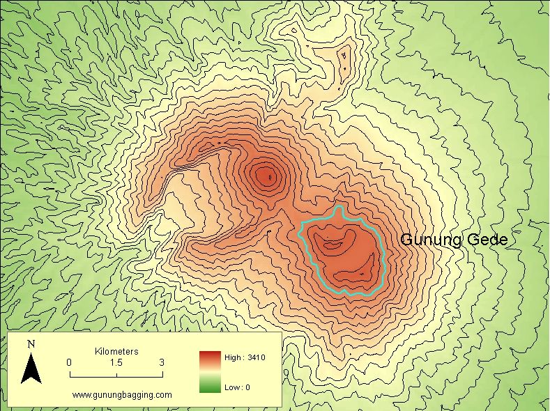 Gunung Gede 2,550 m contour highlighted in blue, which does not encircle any point higher than the summit of Gede. |
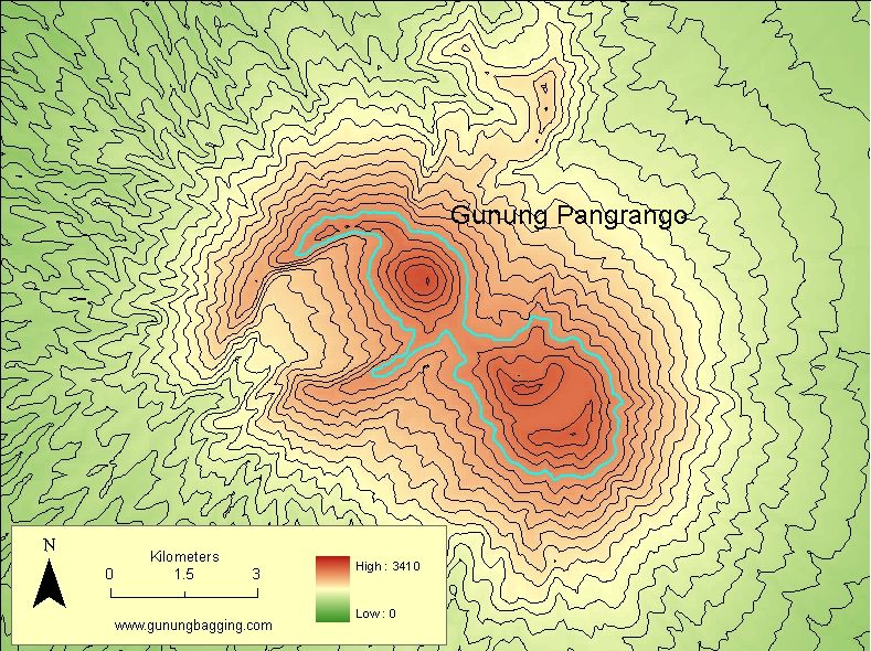 Gede 2,525 m contour highlighted in blue, which encircles the higher summit of Gunung Pangrango. |
The nearest higher summit to Pangrango is Ciremai at 3,078m (also in West Java) but the col between the two peaks is easily sufficient for both peaks to qualify as a Ribu by having over 1,000 m prominence. So, nearby Pangrango is a Ribu because it has more than 1,000m prominence. For the purposes of our list, Gunung Gede is seen as an interesting ‘part’ of Pangrango mountain rather than being a separate Ribu itself. Because Gede is a very interesting and popular peak, in certain circumstances it might be eligible for entry on the Spesial list for peaks which do not have 1,000m prominence. However, we regard Gede and Pangrango as very close neighbours and we would expect that anyone climbing Pangrango would visit Gede anyway as part of the same hike.
Gunung Halimun – a Spesial
Another interesting example is Gunung Salak (2,211 m) and Gunung Halimun (1,929 m). There is a narrow ridge that “connects” Halimun to the higher Salak, which results in a col or saddle of Halimun being 991 m. Based on the difference between the elevation of Halimun and the col, Halimun has 938 m prominence – 62 metres below what is required to be a Ribu.
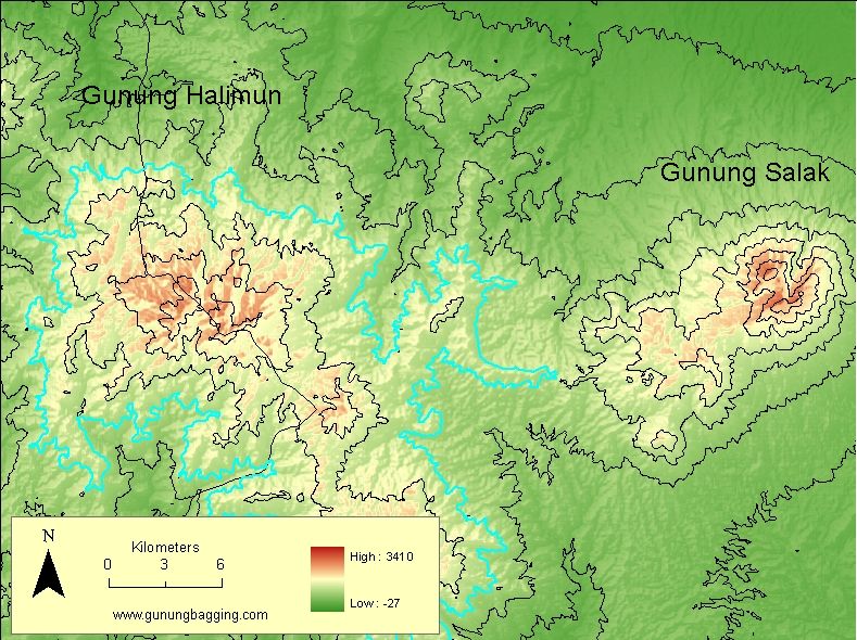 Gunung Halimun 1,000 m contour highlighted in blue, which does not encircle any point higher than the summit of Halimun. |
 Gunung Halimun 975 m contour highlighted in blue, which encircles the higher summit of Gunung Salak. Gunung Halimun 975 m contour highlighted in blue, which encircles the higher summit of Gunung Salak. |
Since it is many kilometres from Gunung Salak, Gunung Halimun feels very much like a separate mountain; you certainly could not climb Salak and Halimun in the same trek as in the previous example of Pangrango and Gede. Therefore, we decided to include Halimun in the Spesial list of exceptional peaks because it is deemed to be of significant interest as an individual mountain area, and it comes very close to having the 1,000 metres prominence required to be a Ribu.
Analysis of Prominence
After we decided that 1,000 metres was the most suitable prominence to identify important mountain peaks across the Indonesian archipelago, the work began to actually create a comprehensive list and accurate geographic locations. Of course, any Indonesian island with a highpoint of 1,000 metres or more qualifies as a Ribu, so that was straightforward. Also, all the Indonesian Ultras (peaks in the world with a prominence of 1,500 metres or above) qualify as a Ribu. Examination of various maps enabled us to identify many more mountains that obviously had a drop all-round of well over 1,000m, but we wanted to follow a systematic approach using standard data and repeatable methods.
Data
Elevation data used was the global shuttle radar topography mission (SRTM) v4, which is available for research purposes from Consortium for Spatial Information (CGIAR-CSI). The newer ASTER GDEM data are still considered to suffer from too many errors in areas of persistent cloud cover like Indonesia, so the radar-based STRM was considered the most reliable choice.
Methods
- A preliminary screening for prominent peaks with a prominence of 1,000 meters was completed using the Winprom software version 2.3 (developed by Edward Earl) and SRTM 30 second data in “divide tree” format kindly provided by Edward;
- The preliminary list of Ribus was imported into ESRI ArcGIS 9.3 as a point “shapefile” for further analysis in relation to the SRTM v4 data;
- The SRTM v4 raster data were converted to 25 metre contours using ArcGIS Spatial Analyst extension;
- The point shapefile representing the Ribus was overlaid on the SRTM v4 data to extract a more accurate maximum elevation value, which was added as an attribute to the point; and
- Finally, the point Ribus shapefile was compared with the contours to determine what was the lowest contour that completely enclosed the point. For example, the the lowest contour surrounding Gunung Rinjani on Lombok island is the coastline at 0 metres elevation because Rinjani is the highest point on the island; therefore the prominence of Rinjani is the same as its elevation.
There are some potential errors in the prominence and elevation figures for the Ribus as a result of the input data and the method of analysis. The SRTM v4 has a published quality assessment (pdf 2.5 mb). The method of analysis described accurately identifies the summit elevation based in the SRTM v4, but the use of 50 metre contours means that the prominence values have some uncertainty. Since 2009 we have consulted many topographic maps produced by the Indonesian mapping agency (Bakosurtanal), which in some parts of Indonesia can provide superior prominence values to SRTM v4. This has been the basis for numerous minor updates relating to elevation figures. We intend to continue to consult local maps as and when any issues arise such as determining which of two peaks with a very similar elevation is the highest.
2018 Major Update
In 2018, we agreed to extend the coverage of the site to all parts of Malaysia and include all peaks with 1,000m of prominence (or more) across Malaysia and also East Timor. This resulted in many new peaks being listed, along with numerous ‘Spesial’ peaks regarded as worthy of inclusion on the site. Dan utilized the freely available list of global prominence figures published by Andrew Kirmse on his site and on a Google fusion table (spreadsheet and map). Andrew previously worked on the Google Earth project and we would like to thank him for his great, ongoing contributions in the field of global topographic prominence and that of Jonathan de Ferranti and his global terrain data which Andrew used. For those interested in reading more, have a look at Andrew’s detailed website.
We would also like to take this opportunity to acknowledge the important work of Edward Earl (of WinProm mentioned above) and Adam Helman, author of “The Finest Peaks: Prominence and Other Mountain Measures” and someone we corresponded with at the start of our project, both of whom have sadly passed away at relatively young ages.
2025 Another Major Update
After five years of research, 2024 saw the publication of a book containing a complete list of all the Ribus in the world, with information such as name, elevation and prominence. This was the first of its kind. The raw data can be explored at the World Ribus website. This is the best publicly-available data at present though more amendments based on Andrew Kirmse’ ongoing Lidar research are expected by the end of 2025.
During 2025, we are extending the coverage of the Gunung Bagging site to all countries in Southeast Asia. This has resulted in many new peaks being listed, along with numerous ‘Spesial’ peaks regarded as worthy of inclusion on the site. This is ongoing at the time of writing.
The Future?
A small team are also working on an analysis of the Ribus of other objects in our Solar System – including the Moon, Mars, Mercury, Ceres and Vesta. The database of 3,670 Lunar Ribus was first released in February 2026 and represents the first comprehensive peak list beyond Earth.
Interesting Facts about Ribus across the Gunung Bagging site
There are currently 548 Ribus, plus 195 Spesial peaks covered on Gunung Bagging:
- Brunei (BN): 1 Spesial.
- Cambodia (KH): 2 Ribus and 6 Spesials.
- Indonesia (ID): 235 Ribus (including 3 on the border with Malaysian Sarawak) and 102 Spesials (including 2 on the border with Malaysian Sarawak).
- Lao (LA): 47 Ribus (including 6 on the border with Vietnam and 3 on the border with Thailand) and 2 Spesials.
- Malaysia (MY): 36 Ribus (including 3 on the border with Indonesian Kalimantan and 1 on the border with Southern Thailand) and 44 Spesials (including 2 on the border with Indonesian Kalimantan).
- Myanmar (MM): 79 Ribus (including 2 on the border with Thailand) and 11 Spesials.
- Philippines (PH): 66 Ribus and 16 Spesials.
- Singapore (SG): 1 Spesial.
- Thailand (TH): 34 Ribus (including 1 on the border with Peninsular Malaysia, 3 on the border with Lao and 2 on the border with Myanmar) and 6 Spesials.
- Timor-Leste/East Timor (TL): 6 Ribus and 1 Spesial.
- Vietnam (VN): 58 Ribus (including 6 on the border with Lao) and 7 Spesials.
Of the 548 Ribus in SE Asia, 58 are over 3000 metres high, 194 are between 2000 and 3000 metres high, and 296 are between 1000 and 2000 metres high.
- Highest Ribu in SE Asia: Hkakabo Razi (5,881 metres elevation) Eastern Myanmar
- Lowest Ribu in SE Asia: Mount Iraya (1,009 metres elevation) Batan island, Luzon, Philippines
- Most prominent Ribu in SE Asia: Puncak Jaya – Carstensz Pyramid (4,884 metres elevation and prominence) Papua, Indonesia
- Westernmost Ribu in SE Asia: Boinu Taung (2,521 metres elevation) Western Myanmar
- Easternmost Ribu in SE Asia: Gunung Antares (3,955 metres elevation) Papua, Indonesia
- Northernmost Ribu in SE Asia: Hkakabo Razi (5,881 metres elevation) Eastern Myanmar
- Southernmost Ribu in SE Asia: Gunung Wanggameti (1,225 metres elevation) Nusa Tenggara Timur, Indonesia
- Island with the most Ribus in SE Asia: Borneo (61) although New Guinea has more (88) if PNG is included