
Facts
- Elevation: 3,145 m (10,318 ft)
- Prominence: 2,432 m
- Ribu category:
 Sangat Tinggi
 - Province:
 Jawa Tengah (Central Java)
 - Coordinates: -7.4542, 110.4397
- Rating:

 (45 votes) Add your rating
 Loading...
 - Other names: ꦒꦸꦤꦸꦁꦩꦼꦂꦧꦧꦸ Highest peak is called Triangulasi.
- World Ribus ID: 69022
Photos


Bagging It!
This Ribu is one of the most popular hikes in Central Java, and has spectacular views to other volcanoes in all directions from the summit area. It has five calderas, Condrodimuko, Kombang, Kendang, Rebab and Sambernyowo but no serious volcanic activity has been reported here for many decades. Merbabu can be climbed from several trails near Kopeng in the north (less than two hours by car from Semarang) with starting points at Thekelan, Cunthel and Wekas, or from the south at Selo (between Merbabu and Merapi and closer to Solo).
There are also newer trails from the west at Suwanting and Grenden which are getting popular with hikers from Yogyakarta. As is often the case in Central Java, the basecamps at the trailheads (especially Wekas and Cunthel) are great places to get some rest, cheap coffee and noodles, and chat to other hikers.
The best hike is probably a traverse from north to south, because the climb from the north is a gentler slope and there are great views to Merapi when descending on the southern route. However, for those travelling from Jakarta for the weekend, it probably makes sense to use two of the northern trails as buses and trains to/from Semarang take at least two hours less than to Yogya and Solo. Do note however that there is a tricky section of trail just below the summit when approaching on one of the northern routes and not all hikers may be keen to attempt this.
This hike could be completed in a day by very fit people, but an overnight stay on one of the summits is recommended. From the north, the hike is called the “seven summits” based on the fact that are indeed seven summits, although a few of them are more of a small bump on the ascent.
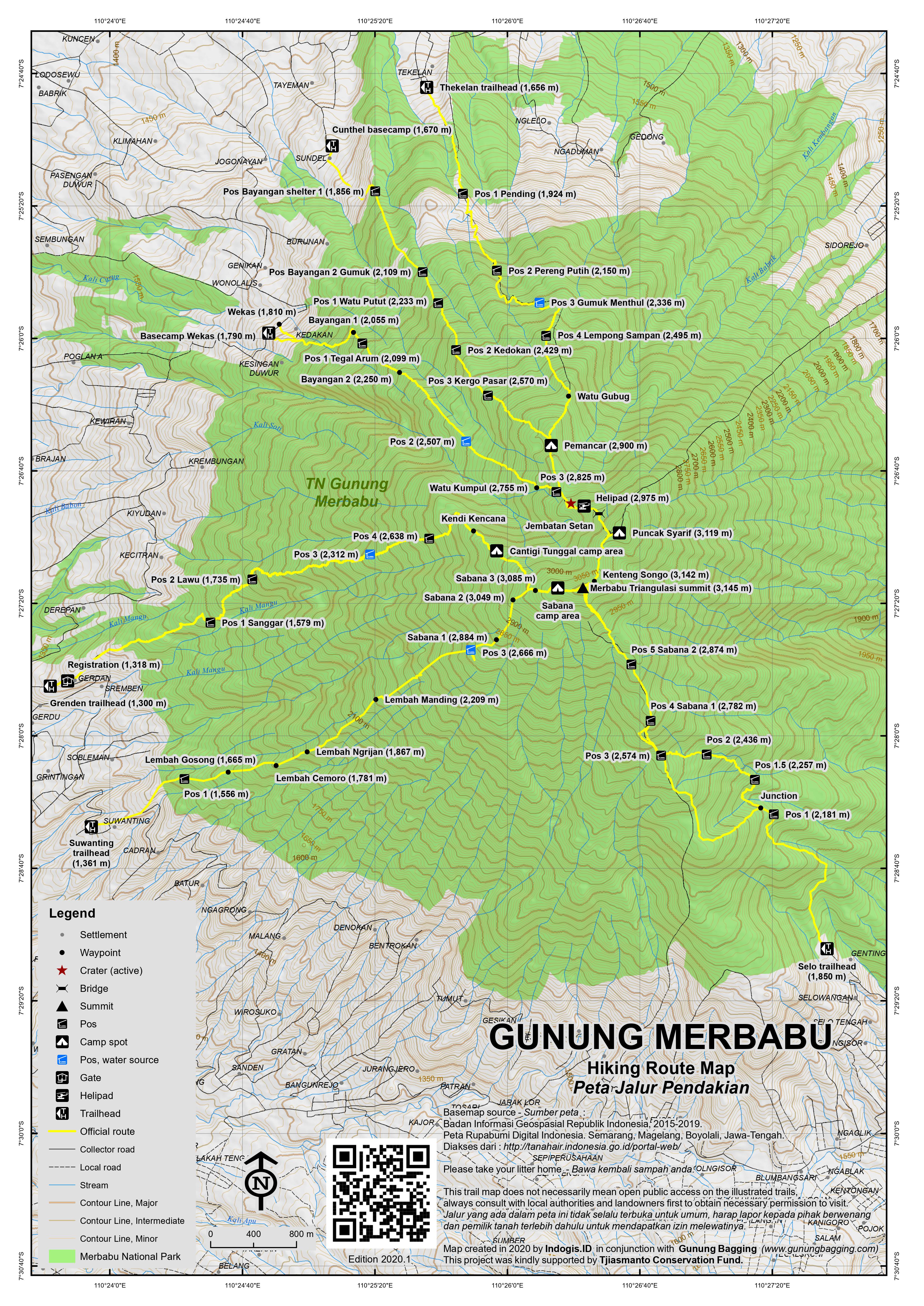
The starting point closest to Kopeng is Thekelan village (1,656m elevation), where you are requested to register at the tiny National Park Office. It is a long 6 to 8 hours up to the summit and you will need a sunhat and sunscreen as most of the trail is not forested. This has an upside of course – views are breathtaking, particular towards Sindoro and Sumbing.
There are 4 “pos” or shelters: 1) Pending (1,924m); 2) Pereng Putih (2,150m); Gumuk Menthul (2,336m) where there is a water source; and Lempong Sampan (2,495m). Strong hikers should take no more than 2 hours to reach Pos 4, but your porters may need longer. After the 4 pos, there are the seven summits. The first is Watu Gubug (2,735m) and the second is more obvious and called Watu Tulis or Pemancar or Menara (‘tower’ in English) (2,900m) where there is an old radio mast. It should take strong hikers no more 3 hours to get to this point.It is also where you meet the trail to/from Cunthel.
After Watu Tulis/Menara/Pemancar, the path drops down a little to Batas Kabupaten (2,825m) – a short cement pillar marking district boundaries also known as Pos 3 Wekas. Here you meet the path coming up from the third northern route, Wekas. Just before the climb starts to Summit 3, there is a possible source of water near to an obvious crater area – a large outcrop of white/yellow sulphurous clay soil. You are likely to be able to smell sulphur in the air. You drop down an obvious path to the right and if you are lucky can hear the stream below very clearly. This area is a popular camping spot for those who do not want to hike all the way to the summits over 3,000m. If you do camp here, it means an early morning start if you want to get to the summits for sunrise, and you’ll miss the best views of the sunset.
Continuing along the ridge, the climb starts to Summit 3 via a flat area known as Helipad (2,975m) where there is a prominent memorial. To the right is an attractive minor summit called Gunung Kukusan, which strangely is not included in the ‘seven summits’ list. Summit 3 is Geger Sapi (2,987m) is not really much of a summit, and is more of a small hump on the fairly relentless steep climb towards Summit 4. This section is known as Jembatan Setan (Devil’s Bridge) and offers great views back down to the north – from some angles the range resembles Machu Picchu.
As you reach the summit ridge (3,080m), you can turn left to climb the last few metres (i.e less than ten minutes) to Summit 4, Puncak Syarif (3,119m). This is a fabulous camping spot, with views of Sumbing, Sindoro, Merbabu’s highest summits and Merapi. There are surprisingly many good flat camping areas, and you may well have the whole of Puncak Syarif to yourself, until the sunrise hikers make their way up from Summit 3.
Another good camping spot is Summit 6, which is near the true summit and called Kenteng Songo (3,142m). To reach Summit 6 from Summit 4, you drop back down and hike along the ridge between the summits. The path actually passes around the south-east side of Summit 5, Ondo Rante (3,100m), before the final steep climb to reach Summit 6. Both Ondo Rante and the steep scramble beneath Kenteng Songo are a little challenging, but whereas Ondo Rante can be avoided, if you want to bag Merbabu from this side you will need to take great care ascending a steep, rocky section of cliff then scree with a little bit of exposure.
Kenteng Songo has numerous signs at the top and seems to be the most popular of all the tops, especially at sunrise during weekends, when many hikers head up from Selo. Most of interesting of all are the ancient-looking stone jars at the top which look like miniature versions of Laos’ famous stone jars near Phonsavan. A short hop from Summit 6 is Summit 7 – Triangulasi – which appropriately has a pile of stones and a blue cement rock at the very highest point (3,145m). Triangulasi is the true summit of Gunung Merbabu, being three metres higher than Kenteng Songo.
All three of the main campsite areas offer wonderful views eastwards to Gunung Lawu, northwards to Telomoyo and Ungaran and south to Gunung Merapi, but the highest peak is definitely the best for watching Merapi.
Dscent to Selo (the village nestling between Merbabu and Merapi)
The trail leads down from both Triangulasi and Kenteng Songo. This will take at least 4 hours and is hard on the knees. It passes through Jemblongan, Pos 5 Savana 2 (2,874m) and Pos 4 Savana 1 (2,782m), all of which are very popular with campers.
After the steepest part of the descent, the trail divides at Pos 3 (2,574m). The left (more easterly) option is a better choice. It leads down through some open forest that becomes a denser as you descend further via Pos 2 (1,436m), Pos 1.5 (2,257m) and Pos 1 (2,181m) before which the alternative route meets the main trail. Soon you’ll reach some pine plantation and suddenly see the village that marks your exit from Merbabu National Park, and the end of a fantastic hike. The Selo trailhead is at 1,850m.
The Cunthel trail: The basecamp is at 1,670m. Walk through the friendly village and up the cement track which ends at 1,770m. The trail initially leads through pleasant forest and has several posts as follows…. Bayangan 1 (1,856m) where there is a decent shelter, Bayangan 2 Gumuk (2,109m), Pos 1 Watu Putut (2,233m), Pos 3 Kedokan (2,429m), Pos 3 Kergo Pasar (2,570m). It should take no more than 3 hours to reach Menara where you meet the trail from Thekalan. This trail is a good option to head down on if you are descending back to the north (i.e towards Salatiga and Semarang).
The Wekas trail: The basecamp is at 1,790m making this friendly village a very attractive starting point and perhaps better than Thekelan. Following a thin white water pipe for a considerable amount of time, the trail leads up past a grave (1,885m), Bayangan 1 (2,055m), Pos 1 Tegal Arum (2,099m), Bayangan 2 (2,250m), Pos 2 Wekas (2,507m) which is a large flattish area popular with campers, Watu Kumpul (2,755m) near an obvious crater area, Pos 3 Wekas (2,825m) which is just before Batas Kabupaten (2,825m) which is on the Thekelan and Cunthel routes too. Strong hikers can reach this point in under 4 hours.
The Suwanting trail: The trailhead is at 1,361m and the trail leads via Pos 1 (1,556m), Lembah Gosong (1,665m), Lembah Cemoro (1,781m), Lembah Ngrijan (1,867m), Lembah Manding (2,209m), Pos 3 (2,666m), Sabana 1 (2,884m), Sabana 2 (3,049m), Sabana 3 (3,085m) before reaching the Sabana camp area just west of Triangulasi summit. Like the Selo approach there are great views to Merapi on this trail.
The Grenden trail: The trail starts at around 1,300m and leads via Pos 1 Sanggar (1,579m), Pos 2 Lawu (1,735m), Pos 3 (2,312m), Pos 4 (2,368m), Kendi Kencana, Cantigi Tunggal which is popular for camping, before meeting the Suwanting trail near Sabana 3 Suwanting.
Bagging information by Andy Dean and Daniel Quinn (last updated in May 2020).
Trail Map
For a high quality PDF version of this and other trail maps, please download from our Trail Maps page.
Featured Guides
- Name and location: Adi, Selo, Central Java.
- Contact details: +6285600345758, Adi.alesana10@gmail.com, https://www.instagram.com/adi_merapi/
- Review from previous client: “I had the pleasure of embarking on Merbabu mountain adventure led by Adi in 2017 and I cannot speak highly enough of the experience. From start to finish, Adi demonstrated exceptional expertise, professionalism, and a deep passion for the mountains.” K Thi, USA.
- Name and location: Sura Mendhol, Selo, Central Java.
- Contact details: +6281548615234, suramindhol507@gmail.com
- Review from previous client: “My guide was Sura Mendhol, he was already mentioned by another person here. He is very experienced (having lived between the mountains all his life) and his English is good, so I can recommend him.” Jari, Austria.
Practicalities
- Getting there: For domestic flights from or to Central Java, such as the airports in Semarang, Solo (Surakarta) and Yogyakarta/Jogjakarta we recommend Baolau. There are plenty of flights and train services from Jakarta to Semarang, Jogja and Solo. From there, public transport is available to all starting points but it will take much longer than if you can arrange your own transport.
- Guides and GPS Tracks: Want a PDF version for your phone? Looking for a guide? Need GPS tracks and waypoints? Gunung Merbabu information pack can be downloaded here.
- Trip planning assistance: Would you like Gunung Bagging to personally help you in arranging your whole trip? Please contact us here.
- Permits: Register at one of the basecamps and pay the small entry fee. Take a photocopy of your passport photo page with you.
- Water sources: Available at Pos 2 on the Wekas route. Supplies usually available at Gemuk Menthul (2,330m) and sometimes between Watu Tulis (2,900m) and Summit 3 on the Thekelan route. Usually available at Pos 3 on the Suwanting route and Pos 3 on the Grenden route.
- Accommodation: Try the Booking.com map above or use this link to search for suitable hotels, homestays, resorts and apartments for your trip.
- We recommend Safety Wing as travel insurance for overseas travellers and tourists hiking up to elevations not exceeding 4500 metres.
Local Average Monthly Rainfall (mm):
Location
Click on the blue arrow ![]() (top right) to see your current location on the map
(top right) to see your current location on the map
Origins and Meaning
Ashy Mountain. The name Merbabu probably evolved from merabu or merawu which consists of the prefix mer– and the base word abu or awu. Mer– (same as the Indonesian-Malay ber-) means “to have/possess the quality expressed in the base word”, and abu / awu means “ash”. So Merbabu means “the ashy one” referring to ash expelled during the mountain’s incessant eruptions. Merbabu hasn’t erupted in recent historical times, but the name Mount Ashy may represent a memory of the mountain that goes back well beyond recorded history. See also Mount Lawu. (George Quinn, 2011)
I went for a day hike with Pak Adi Alesana together with my son. Pak Adi is a great guide, very professional, very experienced and knowledgeable and also very kind and caring. He was very helpful from the start as he picked us up in Borobudur and he warmly welcomed us with his family to stay in his house before the night climb. We had a separate room and slept well. We had a nice nasi goreng prepared by his wife after the climb. He also dropped us at the airport at the end of the trip. All was perfectly well organised and on time. He chose very nice warungs for meals on the way as well. I can only strongly recommend him. He can basically arrange everything from arrival in the region to departure.
His number (Whatsapp) is +6285600345758.
We went on a 3 day 2 night hike of volcanoes Sumbing and Sindoro together with our guides Adi (+62 856 00345758) and Glondor. We originally wanted to do Merbabu but as it was closed due to rainy season we opted for these 2 volcanoes. We had a really amazing experience! We were the only European tourists and the views and nature and whole experience, including the kojeks for the first few kilometers, were really special. Just be aware that it is quite cold at night and at the summits, so be sure to bring warm clothes. The guides were super friendly and welcoming so would highly recommend!
thank for your attention Mr jesper and emma. Thank you for your trust in our guide. Have a nice holiday and see you next trip
Best regard
Adi
While this review is coming slightly late, the memories of my day hike of Merbabu summit via Selo in July 2023 is still crystal clear to me. Initially, I wanted to hike the mountain by getting a permit independently, I eventually chose to hike with Sura as my guide and it definitely made the processes alot smoother.
The views when climbing Merbabu is definitely magnificent, and I was extremely fortunate that the skies were perfectly clear on the day I climbed, probably an encouragement for being one of the first few mountains i ever climbed. You’ll get an excellent view of the farming landscapes surrouding the mountain, city in a distance, along the distance outlines of Mount Lawu, Sindoro, Sumbing, Slamet and of course, Mount Merbabu’s sister volcano/mountain, Mount Merapi.
The hike up Mount Merbabu is of moderate difficulty, especially on some of the paths higher up which were sandy. I was a novice climber back then, so some training would definitely help. The temperature is comfortable but be sure to have some sun protection.
The journey up the mountain first begin with Sura picking me and my friend from our accoms in Yogyakarta, followed by a simple coffee and briefing at Sura’s place. We were late on a few occasions: getting to the pickup point and getting to the summit, but he waited patiently for us, and frequently made sure we were well to continue, even though we were behind time. His experience and strength as a guide were likely a great inspiration and encouragment to help me get to the summit before dark to enjoy the views on top, which I greatly appreciate and remember till today. While every mountain is different, Merbabu being one of the first mountains i summited, made it special and I am definitely very grateful for Sura as my guide then. Throughout, the journey up and down the summit was thoroughly enjoyable, with great conversations with Sura that helped me get a great perspective about Indonesia’s culture. Also learned that hes really into photography back then. The trek ended with a simple yet delightful meal prepared by Sura’s family at his place, afterwhich he sent us back to our accoms in Yogyakarta.
If you are looking for a guide that speaks good english, is hospitable, friendly, experienced and patient, you will definitely have an enjoyable time with Sura as your guide and host, and you’ll be able to learn more about how the local people live. Would definitely hike with Sura when I go back to Central Java. Feel free to leave a question.
His contact number might have changed since I last hiked with him but you will probably find the most updated contact here:
https://www.instagram.com/suramendhol_guidemerapimerbabu/
Today I climbed Gunung Merbabu as a 1-day tour with guide Adi from Selo. It was a great tour, and Adi was a perfect guide, who also could tell a lot about the local volcano history. Adi was very flexible in adapting the plan to my wishes.
He took care of everything, came to pick me up in Yogya the afternoon before, and dropped me back off in Yogya and even invited me to his home for dinner, to stay overnight, and for lunch after returning from the tour. It was a great pleasure to stay in his house. Thank you, Adi!
I genuinely cannot recommend him enough if you plan to hike Merbabu (or other volcanoes in Central Java).
I hope to plan another hike with him in the coming weeks.
Hi Dick,
Thanks for your comment. My wife and I will go to Merbabu in November. Could you give us email address or phone number of your guide Adi or way to contact him?
Frederic – Nice (France)
I found the contact a little further down in the site…
Dear Hikers…
Merbabu Selo route officially Closed on 3rd-4th August 2024. due on “Merbabu Trail Run” held.
Thekelan, Wekas And Suwanting route Still open, but Better avoid that date… will be so crowded.
please Check my Instagram here: @SuraMendhol_Guide
https://www.instagram.com/suramendhol_guidemerapimerbabu
for the official
letter from the Merbabu National Park.
Best Regard,
Sura Mendhol
I just returned back from climbing Gunung Merbabu through the Selo trail. It was a very good hike with spectacular views of other peaks from the top. I did a one day hike with Adi as my guide for the trek. It around 4.30 hrs to make it to the summit. The temperature is very low, so make sure to bring some jackets. Also water and some snacks are a must. The descent back to Selo took around 2.30 hrs. Since it was my first time here, having a guide was of tremendous help as the trail gets a bit confusing at times. Adi was extremely knowledgeable and has some pretty interesting facts about the volcanoes in Indonesia in general. All in all, it was a really great experience.
I’ll share Adi’s contact incase someone wants to get in touch – +6285600345758.
Thank you for your review Mr Abi. I hope you enjoy our guide. Have a nice day.
Best regards,
Adi
What is the current rule for foreigners on a work permit (KITAS)? Do we pay “domestic” registration fees, as in other places? How do we enter the info in the system? Is the “party of 3” requirement for everyone, or just foreigners?
I’m also looking for this information, as i have a student kitas. So if you got info about that, please let me know. Thanks
Now Kitas can no longer be used to register tickets
Summited Gunung Merbabu on 1/7/24 via Gancik.
Although not an “official route,” there are still a couple of base camps located near the trail head where one can register, rent equipment for a modest price, and take an ojek. The ojek was 50,000 rps and I was pretty happy we decided to pay because it was a pretty long ride and the first section from the base camp is very steep. We walked about 3 hours to Sabana 1, which is where we camped for the night. The way up is extremely steep and there aren’t many moments of relief. Actually I’d say it was one of the steepest trails I’ve hiked in Indonesia! Camping at Sabana 2 is also possible but we were advised that the first is preferable due to high winds at Sabana 2. Unfortunately there are heaps of trash at the site, some of the worst I’ve seen on Indonesian mountains. Judging by the size of the trash bags left I’d say they’re from porters and large groups. Shame on you, if everybody was so careless with their waste even the messiest people wouldn’t want to come to these mountains. I hope one day outdoor education in Indonesia can improve so people can understand the value of the Leave No Trace principle. I also hope that someday the money that is collected via registration fees can be put towards something valuable, such as extensive clean up programs. Such beautiful scenery can be destroyed so quickly by trash. Anyways… We had a very misty ascent followed by a rainy night. In the morning we set out at 3am to head for the peak. In a little under two hours we arrived and found ourselves a nice spot to watch the sunrise. It was freezing up top and I was thankful to have brought my sleeping bag since we got up so early. Now one mistake I made was being too eager to watch the sunrise, not even stopping to look at the lava flow from Merapi in the dark when I had the chance. I’m not even sure if the lava flow is super visible from the north like it is from the southwest, but do take a look and see. After the sun rose we could see small eruptions and a guide pointed out there was in fact some lava flow, only not really visible in the daylight. You can spend a good amount of time exploring all the different peaks on top, but my group was tired and we descended after taking in the view of Merapi for a while. The way back down, especially from Sabana 1, was a steep, muddy, and slippery mess. Probably would be much easier if it hadn’t rained the night before. There are a number of ropes on the steepest parts to help you down. Overall a great mountain, amazing and diverse views from the peak, and so awesome to see so many 3,000ers from the top, all of which I had already climbed or was planning to climb (aside from Merapi of course :P)
In order to purchase tickets at local rates, you must present one of the following four documents:
1. Indonesian Identity Card (KTP)
2. Indonesian Driver’s License (SIM)
3. Indonesian Child Identity Card (KIA)
4. Indonesian Student Card
Both Kitas and Passports are classified in the same category, and foreigners are expected to pay accordingly.
It is mandatory for all Mount Merbabu climbers, regardless of nationality, to be part of a group with a minimum of three individuals. This rule is imposed by the National Park authorities due to the significant number of accidents on Mount Merbabu. Climbing in a group of at least three people ensures that help can be quickly provided in case of an emergency. For example, if one person is injured, one stays with them while another goes to inform the national park ranger.
Best regards,
Sura Mendhol
I had an exceptional experience with my guide during the climb at Mount Merbabu. Their extensive knowledge of the terrain, coupled with a genuine passion for sharing insights about the flora and fauna, added a whole new dimension to the journey. The guide’s attentiveness to the group’s well-being, safety, and pacing made the ascent both enjoyable and manageable. Their expertise enhanced the overall adventure, creating lasting memories against the stunning backdrop of Mount Merbabu. I highly recommend Adi for anyone seeking a knowledgeable and personable guide for this incredible climb.
Is this a genuine review or something written by ChatGPT?
2 of us newbies summitted Merbabu in August with the help of Sura and another guide. They were strong hikers and took care of us all the way up and down. Warning for those who’ve not been up that high before: it can get really cold once the sun is down, the night was about 5 degrees when we slept and in the morning as we made for the top there was frost on the plants in various portions. We did have some trouble sleeping through. The meals prepared were excellent, pre and post hike meals were at our guide’s home and featured homegrown vegetables. Fee might feel a little steep but everything’s taken care of.
Very enjoyable hike up and down the Selo route last month. Good camping area, great views and not very crowed on a weekday. Our guide mentioned on this site -Sura Mendhol,( whatsapp +62,815 4861523 suramindhol507@gmail.com), was an excellent guide, super nice guy and made the entire trip totally hassle free, definitely recommended.
Hi, Mr. Bill,
Thanks for your review.
You wrote an uncompleted number,
This is the correct number:
+62 815 4861 5234
You can also find me on Facebook, Instagram, and TikTok :
“SuraMendhol_Guide”
Best regards to everyone,
I’m waiting for you here at my home, which is located between Merbabu and Merapi. Drink some tea and talk about volcanoes, nature, and local life. 🙂
Sura Mendhol
I was planning a Merapi hike initially but it’s still closed at time of writing so I opted for it’s big brother, Gunung Merbabu.
Through Dan I got the contacts of Adi who I cannot praise enough!
What a beautiful human being: pleasant to be around, has humour, humble, knowledgeable of the region in hiking paths and culture and professional!
I genuinely cannot recommend him and his team enough if you plan to hike Merbabu (or Merapi once open again) from Selo!
He took care of everything admin, came to pick me up and drop me back off in Yogja and even invited me to his home for lunch! His hospitality knows no bounds it seems. Also, his wife is a great cook! 🙂
Will definitely plan another hike with him once I get back.
For contact details, please check with Dan – he can get you everything you need!
Hahaha thank a lot mic thank for everything see you next trip and have a nice day
We went up Merbabu via Wekas in early Sept because the road via Selo was under repair. Unlike the videos seen on social media for the Selo route, the Wekas route was pretty quiet, probably also because we went on Monday. Being amateur hikers, especially me as a female, it wasn’t easy with some really steep slopes or to me almost vertical but I made it with alot of help from Sura and his team,hand holding at times! Totally worth it for the view at the top. Quite an experience for first timer like us. Sura prep us what to bring prior, did all the admin stuff and took photos for us when we no longer has the energy to do so. Spoke good English so communication was no issue – really important. Suggest to WhatsApp him in advance of your trip if you want a reliable English speaking guide. Sura Mendhol
Whatsaap: +6281548615234
Email :
suramindhol507@gmail.com
Have fun!
I had the pleasure of embarking on Merbabu mountain adventure led by Adi in 2017 and I cannot speak highly enough of the experience. From start to finish, Adi demonstrated exceptional expertise, professionalism, and a deep passion for the mountains.
On a personal level, Adi is a fantastic communicator and a great motivator. He kept our spirits high even during tough ascents and made sure everyone in the group was comfortable and well-prepared. His patience and encouragement were truly commendable.
I wholeheartedly recommend Adi’s services. He is not only guided us to the summit but also left us with a deeper appreciation for the beauty and majesty of the mountains. I can’t wait to join another expedition led by Adi in the future!
Here is the contact detail of Adi –
Mobile: +6285600345758
Email: Adi.alesana10@gmail.com
I climbed with XXXXXXXXX last October. Perfect trail; with an amazing view on top. XXXXXXXXX takes care of food and drinks, perfect to have a hot coffee at the end. Heavy rain for the way back, quite fun and very safe; thanks to XXXXXXXXX
I went up there in 2017 and still to this day, one of the most exciting hikes that I did. It is quite challenging and i was lucky to have the best guide you can find on this Island. XXXXXXXXX is super experienced, very kind and just the person you want to have next to you when going on an adventure. We are still friends to this day.
From Portugal
Jan
Lovely little climb. Going up from Selo, I’d give it a “moderate” difficulty ranking, easier than the specs indicate. Most of the walk is on a steep, solid path, it’s only for the final 300m up that the path gets steep and a bit slippery, loose sand on steep slopes. We campled overnight at about 2600m, then made the ascent before dawn to arrive at sunrise. A friend and I went up with XXXXXXXXX, who is an excellent guide — certainly a strong hiker and climber, he said he’d won the silver medal for some Merapi Extreme Trail Running event a couple of years earlier. He responded to my messages quickly, organized all the tedious admin stuff, and provided tent, bag, mattress and so on to my friend, who didn’t have his own. He asked about our food preferences and cooked up some good meals. His prices are comparable to other guides. He asked me to leave a review for him here, and I’m happy to do so. He can be contacted at XXXXXXXXX
We wouldn’t have hiked up the mountain successfully without the help of our favourite guide, XXXXXXXXX He’s very helpful, patient and friendly, always making sure we are safe and well-taken care of throughout the journey. Would 101% recommend XXXXXXXXX if you’re looking for a guide for your trip!
We did the trekking with XXXXXXXXX and everything was perfect. He is a very good guide and he even took care of our 11 years old son at the last step of the trek when he was really tired.I strongly recommend him.
Enrique
I went to Merbabu in 2017 and it has been one of my best scenery of my life. The view at the top is amazing for sunrise above the clouds. I arrived the day before in Selo.
The hike is quite challenging and by night I definitely recommend to make this adventure with a guide. I’ve done it with XXXXXXXXX on Instagram and it was super cool, really nice guy and professional who knows every parts of the mountain
Thank you So much for the information… So beautiful mountain. I Climb wih Sura (+6281548615234) he is awesome. The registration so tricky, But Sura Make it easy.
I’m heading to Merbabu tomorrow, planning to do an overnight up and back via Wekas. We wanted to do a traverse from Selo to Wekas but all the basecamps told me that was no longer allowed. It also didn’t seem possible to register for that on the national park website.
I’ll report back how it goes!
Super nice hike! We left Wekas at about 1am with a party of 18 guests and 3 guides, and all of us made it to the summit between 4:45pm and 6:00am. Absolutely surreal views down to Merapi, out over Sumbing, Sindoro, and Prau (honestly looked like something from Zelda), and out in the other direction to Lawu. We left the summit around 7am and we were all back down before 11:30. There are a handful of tough bits, but overall it was a great track with nothing too incredibly challenging. It was a bit cold at the summit, so do bring layers.
I will go out of my way to recommend the guides we used, though. Ahmad and his friends (IG: @guide_portermerbabu) were unquestionably the best and most professional guides I’ve hired in Indonesia, and I’ve used like a dozen or so different groups. Constantly making sure nobody was struggling, showing the exact footsteps in tricky parts, and radioing each other to check in when the group got spread out. They don’t speak much English, but as long as your language skills are up to it, I’d strongly recommend them for any hiking/guiding you’d need.
Just hiked Merbabu from Selo today. Hiking done solo, without guide and by the rules as a foreign tourist.
Arrived in Selo by 4pm the day before. Got a room in the homestay street. Picked the place randomly. I havent compared but i think they all charge a flat fee of 200k/night/room. Room was pretty bare but the bed is ok, not the cleanest bathroom but hot shower. For cheaper options go the the trailhead, there are several basecamps with dormitory options.
Drived to the trailhead. You pay a 5k (i guess per person) for entrance and 5k for motorbike parking. I used the same ticket the next day.
Went to the NP office to buy entrance tickets as i was planning to hike by 2AM (when the office is closed). Turns out :
# It’s now forbidden to enter the trailhead between 4PM and 8AM. If you want to see the sunrise then camping is mandatory.
# No permit can be issued on site without a prior online booking (which can be done live provided that there are still slots for hikers available). This is different from Semeru where, in 2018 at least, foreigners are not required to book online and are not concerned by the hiker treshold. To register online you need a NIK number that no foreign tourist has.
# Registration online can only be done for a group of minimum 3 people. If you are solo (like me) or 2 then you cannot register online and without online registration you cannot buy permit and thus cannot hike.
But it’s possible to get away with it :
# The next steps assume that the number of maximum hikers registered is not reached yet. If it’s full then there is nothing to do but come another day. You can check the number of spot remaining online on tngunungmerbabu website. Outside weekends and public holidays then it should be ok.
# To register online as a foreigner (must be 3 people minimum, no matter if indonesians or not), input the following as NIK (instructions from TN staff) : 1360000000000001 (for the first foreigner in the group, change the last digit to 2 for the second one and so on). Basically 136 at the beginning, 1 (or 2, 3 … If several foreign hikers) at the end and lots of 0 in the middle. The total must be 16 digits.
You also need to put a full Indonesian address as per your KTP (so street, then town, then province, then kabupaten, then kecamatan) so you cannot use the one on your passport. I picked my old address in Jakarta but you can put the address of your homestay in Selo. Province, Kabupaten and Kecamatan must be selected through a drill down that is sorted by province then by alphabetical order. I guess it’s a bit confusing if you are not familiar with Indonesian admin. division. Ask for help if necessary.
# Then you need to be 3. If you are 1 or 2 how to do ? 2 solutions :
* You hire guide + porter (or just one if you are 2) and that makes a party of 3.
* You join an existing group. Ask the rangers for help. It’s not an issue to join a group even though they are camping overnight and you don’t. Just report when coming down by the rangers.
The best case would be to find other people who haven’t registered yet and register with them. This is what happened to me. I paid the two guys permits of course to thank them (very low price as they were Indonesians).
It is also possible to find someone already registered, cancel his booking and remake a booking with you in it as additional members. But making a booking requires lots of info (like NIK, name, address, phone …) so people may be lazy to do it.
Important thing : each registered group must declare everything he brings up (up to the numbers of cigarette) and this is checked back when returning. So if you do the day trip and others camp you must coordinate so that the campers bring back your trash with them. Big fines can officially be given in case of discrepancy.
So for the actual report :
Went back to the trailhead at 7:30AM. Rangers told me to wait for other hikers to arrive. I was never pressed to hire guide or porter. Overall the staff was really nice and helpful. Don’t know about their ability to speak English, we used only Indonesian.
The ranger went to ask the first people he saw. Turns out they were 2 old school hikers and haven’t registered either. I took care of the registration on my phone. One is the leader and must provide a bit more info. One identity document for the whole group must also be left with the rangers when departing. If only some members are camping then pick 2 nights still and the leader must be a camper. Inform the rangers who is camping or not (they call it tektok).
Once you filled everything, you receive an email with a code. You enter the code back, there is then a last button to press and the rangers see your booking.
Then they gave us a form where you must list everything the group carries, including plastic bags, water bottle and cigarette. This is checked back on return.
Once it’s done I paid the permits. Flat fee of 5000 per person (hiking fee) + 2000 for insurance per person. Then 5000 per days for locals and 150’000 for foreigners (weekdays, more expensive on weekend and public holidays). If you camp you pay for 2 days. Then a 15’000 ranger fee must be paid for the whole group.
Then we started hiking. I quickly left behind my 2 companions as I was carrying a much lighter bag. Left the basecamp at 9AM (time to fill up all the paperworks), summited (Triangulasi) at 12:40. 50minutes on top then descended at 13:50, was back at 15:30. My fitness was not exceptional and I’m sure the hike can be done faster.
Met the 2 other guys I registered with a bit above Savanah 1 and gave them my trash (1 empty water bottle, biscuit package and bungkus). I kept one water bottle for my descent, I reported it to the rangers so that the other guy don’t get a fine when coming down the next day and it was fine.
The trail is obvious, well worn and without much difficulties. Can be slippery on the way down.
Weather was sunny and dry. I guess most of the trail gets very slippery in case of rain. Merbabu remained perfectly clear of clouds all the time. Merapi was clouded on its right flank (looking at it from Merbabu) left flank and the summit remained cleared. Clouds were getting denser with the day. Views of other mountains from the summit were poor because of clouds surrounding them.
Overall a very pleasant hike and great views despite some clouds. Hat is a must and I drank 2,5L of water.
Last thing : I’ve never seen so little trash on a popular Indonesian trail. There is lots of paperwork at the beginning and was not the only one gently pestering against it. But the rules seem to work, every group is given a trashbag at departure and they use it to avoid fines. Rangers collect trash too. If that is the price to pay to enjoy clean trails then I’m having it.
Hope it helps !
(@Dan : sorry for the repost, but I just wanted my comment to come up on top of the comments, please delete my original comment if you want to).
Super helpful info – thanks for sharing. Attempting the same solo climb tomorrow, will report back on my attempt to beat this climb and Indonesian admin as a foreigner 😉
Reporting back – I ended up opting for contacting Sura the guide mentioned elsewhere in the comments (+62 815-4861-5234) and had a great experience (Sura is an awesome guide and person and got some great views at the top despite the cloud cover).
Sura was able to navigate the complicated entry process for me, I think I would have struggled on my own when not speaking any Indonesian.
Non-Indonesians might want to avoid the Suwanting trail, at least for the time being. I enquired about the ticket price for foreigners, as there is no mention on the official website. The reply came back that they were ‘belum berani’ not yet brave/confident/comfortable with allowing foreigners in, presumably because non-Indonesians are thought to be more likely to be carrying covid(!) I asked him if this was the case for foreign citizens who live in Indonesia and the reply was the same. I finally asked what the difference was in his view. And no reply came. A silence which speaks volumes. So I won’t be bothering with Suwanting even when us aliens are allowed back in, whenever that might be.
That the people who have the right to prevent or allow access to these mountains hold such views is quite saddening. Another covid victory for bigotry and xenophobia.
Am currently enquiring about the more obscure Timboa route from the north-east not to ofar from Salatiga. Fingers crossed they don’t hold my nationality against me.
Well, no problems with my nationality, but a rather larger issue with the Timboa trail. As is usual in Indonesia, the formation of a National Park can often have downsides relating to access (usually it’s the other way around in most parts of the world). And with Merbabu, there are now only 5 official trails. Essentially it’s illegal to hike except if you use one of the 5. This does not include Timboa, so anyone hiking the Timboa trail can now potentially be caught, reprimanded and blacklisted from the mountain for two years!
A bizarre situation for those of us accustomed to hiking in Scotland. You see the mountain, and you hike it. Not so in Indonesia, with increasingly bureaucratic hurdles to leap over before you have even started walking. Take the new Merbabu online booking site. There is little information on foreign citizens, or that permanently confusing grey area of foreign citizens living and working in Indonesia. It barely seems to warrant any attention. But you can bet that if a foreigner was hiking up Timboa and the ranger spotted him, it would be in the press and you could even lose your visa. Not worth it.
But, how would anyone know this? Indeed, how did I know? I was ready, as ever, and on an ojek at 4:30am bound for the Timboa basecamp from Salatiga. My ojek driver told me this was an ‘ilegal’ trail (everything is illegal unless it is specifically written that it is legal – illegal until proven otherwise!) I thought perhaps he was wrong, as there is a Google Maps location for the Timboa basecamp, along with Pos 1,2,3 and so on up the mountain. I had Google Timboa and found very little and wondered why it was so rarely used. But the friendly chap at the basecamp (+6285951671171, djhar1008@gmail.com) was keen on a dayhike up to Puncak Syarif, and it seemed odd that we could get arrested for going for a hill-walk! Anyone with little Indonesian language skills could end up completely confused by all this.
Anyway, I Googled Timboa ilegal and sure enough there were a few articles about hikers being blacklisted for 2 years after hiking unofficial routes, including Timboa. So, especially being a foreigner, I once again decided it would be a bad idea to hike this and risk all sorts of weird punishments. https://m.liputan6.com/lifestyle/read/4620591/nekat-mendaki-gunung-merbabu-lewat-jalur-ilegal-pendaki-masuk-daftar-hitam-selama-2-tahun
Perhaps one day the route from Timboa (NE) will become official. If it does, here are the details taken from Google Maps – note elevations are very approximate:
Basecamp approx 1,400m, Pos 1 Simpangan (1,950m), Pos 2 Pampung Seger (2,050m), Lemah Dhuwur (Sabana 1) (2,250m), Pos 3 Mainan (2,400m), Pos 4 Ki Hajar Sampoerna (2,600m), Pos 5 Watu Lumpang (2,800m), Puncak Pregowati (2,950m) and Puncak Syarif (3,119m – where after meeting other trails up from the north side you can continue along the summit ridge to the true summit).
Is this only an issue in National Parks? I remember in 2011 “sneaking” into Rinjani. We made the mistake of hanging around up on the rim before heading down and a ranger caught us and made us pay the 150k entry fee. I found Java to be mostly pretty good with going up the Gunungs. I would usually arrive at 1am or 3am in the morning and try hike up to the summit. Was much easier than lugging a tent up and spending the night with hundreds of others in the campsite. I guess more and more people are hiking so they are tightening the screws. For us aliens it certainly is a little more effort. Once they drop this PCR before leaving your home country ill be straight back and up the Gunungs once more 🙂
For the online registration for foreigners, any advice on going about that? Do you just fill in the information as best you can and then pay whatever extra fees at the base camp?
We are thinking of climbing Merbabu end December or beginning January. Is there any danger doing it in the rainy season?
Could well be closed January to March.
Yes good chance of heavy rains and no view. However you might get lucky if you go before end of year with a local guide who is happy to start at midnight, so you climb at night with torches, hopefully enjoy the view shortly after sunrise then straight back down before the usual lunchtime or afternoon downpour begins….. but check the weather 48hrs beforehand.
Ascension réalisée grâce à Sura (nommé dans l’article)
Magnifique expérience autant en terme de paysage que de rencontre !
Nous avons eu la chance de manger dans sa maison où le repas était super bon !
Sans hésitez, contacter le pour cette ascension ainsi que d autres sommets dans le coin !
7 July 2019. We took a Grab-taxi from Semarang to Basecamp Thekelan (2 hrs 250.000Rp), registered (very friendly) and paid entrance fee (28.000Rp for 4 WNI). The route from POS 2 to Watu Gebug is redirected because of landslides on the old route, its clear where the path goes. After 6 hours from basecamp we put up our tent at the Helipad, which was very dusty. Just before the helipad on the right side of the track goes a small path into the bush to a little stream, which was the only water after POS 2 (needs to be purified/cooked before consumption). Next morning we hiked up to all peaks and descended to Selo through a steep and very very dusty path in 6 hours (no water in any spot). The mountain was full of hikers and students since it was the last week of holidays. From basecamp Selo we ordered transport to Yogya (400.000Rp), which took 2,5 hrs. Great hike, beautiful views. Would certainly recommend to hike up from Thekelan and descend to Selo and not the other way around as Selo is the very busy area and a very steep, dusty and eroded path.
Just got back from Merbabu and I must say what an awesome mountain!
I wasn’t too stoked with it being a Sunday morning and seeing hundreds of tents and people all climbing the hill but the top more than made up for it.
I left Solo at 1.30am and was at the Selo entry gate at 2.45am. Paid 5000k to park and found the whole place dead. Not a sole around. Went past the gate and straight up the trail. The path from Selo is very wide and atm it is very very dusty and slippery. If you go to hike be sure to take some poles with you, it will help a lot.
I reached the summit after 2.5 hours at 5.15am. There were a lot of people already on the top but it is really big so you just have to walk around and find a spot to yourself. I had some brekky at the top, took some photos and chatted with other hikers. The views are insane from the top and 100% worth the effort to climb.
I left the summit at 6.30am and slow jogged/walked down and was at the gate by 730am, 1 hour down. I was then back in solo before 9am. Amazing trip up the hill.
I’ve noticed that if you go around 2am or 3am there is no one at the gates to collect fees and for us foreigners its quite a saving. So all in all it cost me 5000k for the parking of the motorbike.
hey can Sura contact with me ? Im going to climb the MT merabu at 2rd May
How to whatsapp Sura?please..
+6281548615234 as is written above…..
Okay guys, me and my friend (from Germany) just hiked up yesterday night. I actually was pretty concerned before because you couldn
t find to many information, but mostly that you need a guide. My friend instead was not scared at all and convinced me to go without a guide. So we took a Grab at 9.15 PM from Jogja and drove to the Selo Basecamp. Unfortunately we paid 150.000 IRP for registering –> what for? When you come down no one is asking you for your name or anything! So just talk to your host and tell them what you are going to plan as a backup.. but actually there is no need for neither a guide nor registration. BUT you should not go alone. Better to go with a friend. Download Mapsme before and you will have the trail on your mobile phone. We started hiking at 23.45 on a Saturday evening. A lot of other Indonesians hiked up there as well but planned to stay in one of the campsites. So, you won’t be alone, espacially not on Saturdays (furthermore Mount Merapi was closed so maybe the touristnumber on Merbabu increased). Anyway the track is very easy to find, so it is a muddy track. I would recommend you to hike up if no rain is expected!!! We reached the summit within 3 hours and 45 minutes as we were faster as expected. People told us times between 4 to 8 hours. But if you are in a good condition, there is no rain and you like hiking it is easily possible to do it within 4 hours. At the summit we had to wait for about 1 hour and a half for the sunrise while we could stay in a tent of very kind Indonesian tourists. Take some warm cloths in case you have to wait, it will be very cold during the night on top! Afterwards we went down to Wekas which was a fault: because there is no possibility to get away with neither a Grab nor a bus. With the help of a dude there we would be driven to Kopeng where we had still struggles to get back to Jogja because no one could tell us if there is a possibility to take a bus. In the end very nice people organised us a guy who would drive us back to Jogja for 400k IRP, which is a lot more than Grab would cost, but because there was no Grab available we were after a long hike and being more then 24 hours awake, just glad to get back to Jogja. Next time we would just drive there with our own Scooter but consider a Volcano crossing as we did it from Selo to Wekas wouldn’t be possible. The way down to Wekas was pretty exhausting and took us about 3 more hours. Last but not least it was an adventure, which we would do again for the awesome mountain you get to see. Be in a good shape, a good mood and consider it to be an adventure. Calculate about 8 hours for going up and down. And one last advice, take your garbage back please and collect some others as the mountain is unfortunately full of plastic :(.
Fantastic review. Thank you for this. I will be organising a trip there with a group soon. To make it more of an adventure i wish to go without a guide, therefore after reading your review, I’m more convinced it can be done.
Nevertheless, i’ll keep you updated.
Thanks again.
Planning to climb Merbabu on one of the northern trails. Anyone could recommend what’s the best place to rent a tent and sleeping bags for camping? (Coming from semarang).
Posting here for posterity’s sake: Viktoria and I managed to rent sleeping bags and Tents from the Basecamp at Thekelan at a modest price. 🙂
when u plan to go for hiking? i also planning to climb mount merbabu.
Hello, we a family with 4 children (our little one is 6), climbed Merbabu the 8th of August, 2018. Bit hard at the end, but spectacular on the top. We did it with Sura, mentioned in previous post. He is a very nice guy, helpful, careful. I highly recommend him, and his cost is so low that we almost regretted not to have given him more. Our best souvenir of Java, just before Bromo.
I just climbed Gunung Merbabu from Selo. I decided to do it all in one day, without camping.
My guide was Sura Mendhol, he was already mentioned by another person here. He is 29 but very experienced (having lived between the mountains all his life) and his English is good, so I can recommend him. He also does camping. Just send him a message – (EDIT – deleted)
We started at 1 a.m. and reached the summit at 5, but I think we went rather fast (my mistake, he told me to slow down). Sunrise is at 5.45 and on the top it’s pretty cold, so bring warm clothes and a second shirt (it will be sweaty). The way down was even faster, but as Gerald already mentioned it’s a dusty affair and you slip and slide a lot more than you want to… I would not want to go down this way when it’s raining. We also stumbled upon some aggressive apes but no problem for Sura 😉
All in all I think that the hike itself is not spectacular, but the view from the top definitely is because Merbabu is right in the middle of the island and you can see all the surrounding mountains like Merapi, Sindoro and Sumbing and Lawu.
Hello. Do you have some figures regarding your trek from Selo : number of kms and elevation ? Regards. Gregoire.
It’s About 50km from Yogyakarta city centre to Selo Village.
Start point altitude : 1800m above sea level
Summit : 3142m above sea level
Distance : Startpoint ( Selo Village ) to the Summit : 5.25km
I’m Sura Mendhol,
Thanks to good review about me…
Contact me Here : +6281548615234
If you need information about weather on Merbabu, Local Guide, etc
Hi can i know how i can get into contact with Sura Mendhol? Thank you
We chose to do the south trail starting from Samiran. It’s a short and steep climb. Was crazy foggy, unfortunately we couldn’t see much. We always kinda stuck in the clouds. We aware, the upper half is steep and earthy/dusty. It is a pain in the ass to decent. Will be horrible if there is rain (I would not take the risk). We got lucky in a way, it started raining once we passed that section. But the trail became a river. Not pleasant to descent! So you better check the weather forecast! There was no gate/ticket office in samiran as far in can tell. So we just payed the parking fee at the “base camp”. Would highly recommend to rent a scooter and drive to Merbabu. It is a beautiful ride 🙂
This was my first gunung back in 2009 so I decided it was time for a second visit, and to try some of the other numerous routes available. The first time I went with Java Lava and we hiked up from Thekelan and down to Selo. This time I decided on up from Wekas and down to Cunthel, both northern routes meaning getting the train to/from Jakarta would be fine over a weekend (it’s 6 hours from Gambir to Semarang Tawang as opposed to 8 hrs to Jogja or 9 to Solo).
We arrived at Wekas well before first light and got some rest at a basecamp. Very friendly folk and coffee for Rp3,000. Bargain. Great views to Telomoyo and Andong. Once we were up on the higher slopes my main impression was that I had forgotten just how great the summit ridges are. Once you meet the other northern trails beyond the Tower the views are brilliant in all directions.
From the true summit (Triangulasi) Merapi was still in cloud. There was also a potentially aggressive monkey wandering about – one of the many negatives of hikers leaving rubbish behind on the mountain. Also the same species of very tame bird that hang around on Lawu too.
Not all of us bagged the summit – one hiker was not keen on the rather tricky section below Kenteng Songo – admittedly I had totally forgotten about this too! If you are not sure about rather exposed sections but aim to reach the true summit, best try via Selo to be on the safe side. The small stone jars on Puncak Kenteng Songo are fascinating – a pleasant reminder of my trip earlier in the year to the Plain of Jars in Laos. Does the fact that there are a decent number of local Buddhists living on the slopes of Merbabu have any relevance to this?
Unfortunately the porters were having difficultly and were way behind. We ended up waiting at the junction for Syarif / Kenteng Songo…. until almost dusk when we hurriedly set up the tents near the junction and took a few photos. The following morning we went up Puncak Syarif which is a great vantage point as you can see Merapi plus both of the two highest peaks of Merbabu (which were full of people, most of whom must have hiked up from Selo). Also the reservoir known as Waduk Kedung Ombo just as the sun was rising and the majestic Gunung Lawu.
We were determined not to have porter problems on Day 2 as we had to make it back to Semarang for trains etc. Alas, two of the four were very very slow, so much so that two of us ended up carrying our porter packs back down the mountain (packs which included some of the porters’ own equipment!) Amazing to the point of comical – pay someone to carry your bag but actually end up carrying it yourself plus some of their stuff too! The important thing was that we made it back down in time for trains and flights. Cunthel too was a pleasant place to have a coffee and get changed. Very much recommend up from Wekas and down to Cunthel if you haven’t used those trails before.
I just climb to Merbabu last week… I took Wekas, Magelang rute (North side) and go down via Selo. Actualy I want to climb via Thekelan, but my guide advice me to climb via Wekas. He told Wekas rute are shorter.. And ya… I walk slowly and I make it to the summit only 5 hours… Stuning…!!! Tired but I proud…
Recomend local guide who can lead the trek to climb Mt. Merbabu
He is Sura Mendhol
(EDIT – deleted contact details due to continuous spam)
He life in Selo (south side of Mt. Merbabu)
Experienced, speakin English, can arrange sunrise trekking and camping program.
Hi,
Planning to climb Merbabu some time in July.If i’m coming from Malaysia, where is the closest airport that I should fly to? Is it Jakarta?
Solo, Semarang or Jogja.
It is easy to get there using public transport from Semarang: get a Semarang -> Solo bus & get off in Salatiga at the junction with the road to Kopeng, from there get an angkot to Kopeng & get an ojek from Kopeng to Tekelan. The highest point with permanent water is Gemuk Menthul 2330 Metres where there is a tap. There was no water below summit 3 when I was there in the dry season. The Cuntel route mentioned above is good for descent & probably quicker than Tekelan but better to ascend via Tekelan as as water availability is better on the Tekelan route. It is easy to get from Cuntel to Kopeng by ojek, angkot or walking
Went to Magelang this weekend with the objective of bagging both Merbabu and Merapi. Long story short, I made it. Made my way up to Merbabu’s puncak trianggulasi from Selo base camp in just over 3 hours in time to catch the sunset. Just to let you all know I pay a lot of attention on my fitness and half sprinted my way up the mountain as we had a late start. I was with someone who started off as my guide but is now a very good friend of mine, Bayu Saputra (check resources: Guides on this website). Give him one phone call, and he will sort out the rest for you. Calling him before going to Central Java was perhaps the best thing I did. I had nothing to worry about once I spoke to him from the comfort of my office space in Jakarta. He will make sure that not only you enjoy your trek up to the top, but also ensure you’ve got all your logistics and other details in order before you start and once you get there as well (I’m referring to unexpected issues of any nature whatsoever). If you’re planning a trip there, or to any of the neighbouring mountains, call him. Period. Or you can talk to me as well. I’d love to help out in any way I can.
Cheers!
Hi Gaurav,
Need help with guide and logistics arrangement for climbing Mt. Merbabu. Appreciate if you can connect me to Bayu Saputra.
br,
Bryan Kho
Malaysia
Hey mate,
Here you go.
Bayu Saputra: +62 857 416 713 22
A few other reliable guides in the link below. I’ve talked to a couple of them and they seem to know their way around as well. Type in Merbabu in the search and you should be good to go.
https://www.gunungbagging.com/guides/
Cheers!
hai.. if you need guide to mt.merbabu or mt.merapi, call me 085743974154 (anis ,bayu saputra’s friend ) . Guide for Gaurav Tiwari to mt merapi last year..
To Dan. Gito is an excellent guide and organizer living in Selo (southern approach). His number is 0878 363 522 60. He arranges everything from airport to airport.
Back from Merbabu summit. We started from Wekas and traversed to Selo. I’ll recommend this route. My account of this trek is here http://ghostpipe.blogspot.sg/2013/09/gunung-merbabu-gentle-stroll-from-wekas.html
Our guide was Suroto Sheby, +6287835090433 and email address is surotosheby[at]ymail.com.
Just returned from a fantastic traverse of this superb gunung. We contacted Pak Danar of Kaloka Adventure (http://kalokaadventure.blogspot.com/2011/07/contact-form-name-email-subject-message.html) who provided good service, porters, water, tents and meals (excluding snacks) for the 2d/1n hike.
We did a traverse from Wetas to Selo villages. Wetas is situated west of the Kopeng starting point described by Andy and Daniel above, and is about a 6 hour hike to the camping spot on the ridge between Puncak Syarif and the true summit of Puncak Kenteng Songo. We started in the afternoon (would have been preferable to start earlier but the guides were insistent for some reason) and stopped at several of the post along the way, notably at Pos 1 (1752 mpdl) and then at Pemancar (2504 mpdl).
Starting from Wetas you walk through a conctrete path for about 30 mins up through the agricultural land and then slowly into deeper and denser forest. Very pleasant hike, before eventually emerging into the craggy rock formations, and then spending the night on the ridge connecting the various Merbabu summits. Very memorable spending the night there but be sure to pack warm dry clothes because of the dipping evening temperatures!
After the summit the next day, the descent to Selo is a truly memorable experience, with the backdrop of Merapi guiding you the entire way down. A pretty straightforward 4 hour hike (faster if you are moving fast and willing to slide on your butt down some muddy slopes) to Selo, which is coincidentally close to the trailhead for a Merapi climb. For the truly ambitious a long weekend climbing Merbabu and Merapi is definitely an option!
Hi, did you climb this mountain in March/April? What about the rain? Thank you in advance.
Bismilahirohmanirohim semoga ketenangan tetap terjaga dialam semesta ini
An Indonesian volcano lover is not a true lover before setting foot on the peak of G Merbabu. The summit view is the best in Indonesia, in the same tier with G Rinjani’s.
Aku di magelang, tepatnya di gunung andong.
Tetangga merbabu hehe..
i live in salatiga, i’ve climb this mountain more than 15 times (maybe 20 times :D) and never get bored. very beautiful mountain with wide view (especially from pos watugubug and above). i think best time to climb there is summer where the sky very clear and u can get 360 degre point of view from the summit.
What’s the total distance like for the whole hike? Are u able to cover it in a day hike generally?
Another approach, that joins the Tekelan route at the antenna (2900 masl) is starting from Cuntel village, around 3 km from Kopeng (~ 1450 masl). It might be a shorter alternative, if heading on foot directly from Kopeng. Having not climbed the Tekelan route, i cannot compare the condition of both paths, but the Cuntel route is not eroded and most of the walking is on a black, solid soil with a good grip. The only clay and slippery passages, being an overall exception, are present on the last 100-200 m below the radio mast.
There is an asphalt road on the right (S-SE), starting about 100 m after the centre of Kopeng and the junction (again on the right side) to the Hotel/swimming pool, when coming from Magelang and moving in direction Salatiga. Many hotels are present along both sides of the road. Take the left fork after about 1 km (signposted) and continue for another 2.5 km on good asphalt. Left hand is a lush green forest, right side is agricultural land. Base Camp is situated on the left side, at the entrance of Cuntel village (1600 masl). Continue on the main village street, which turns right straight thereafter and look for a sign on the left. This is the trailhead, starting through some onion fields and turning sharp left and up the slope after 10 min. Soon you reach Bayangan 1 (wooden roof – 1860 masl) and after another 40 mins is Bayangan 2 (better shelter – 2070 masl, water in front). The path continues up and through a denser vegetation, but is clearly visible. Official Pos 1 (Watu Putut – 2145 masl) with an area for 3-4 tents is a short distance from there and after some 30-40 mins you reach Pos 2 (Kedokan – 2300 masl), but a large camping area on a huge meadow can be found at Pos 3 (Kergo Pasar – 2450 masl, no water). Total walking time from Kopeng to Pos 3 should be around 3-4 hours and the impressive ridge and hill with the antenna on top of it is clearly visible from here in good whether. Further the path gets steeper, winding endlessly and gaining a lot of altitude until after 90-120 mins, you join the Tekelan route, several meters below Pos 4 (Pemancar/Watu Tulis – 2900 masl). There is a sign at this junction, marking Tekelan and Cuntel directions. From here you follow the original route description.
I climbed in the wet season starting in Kopeng. Had to turn around at Watu Tulis after sheltering in the shack next to the radio mast due to bad weather.
Freezing cold but good fun
I sat in the same shack for 2h (Nov ’10), sheltering from raining ash from Gn Merapi and waiting for the sunrise so we could carry on to the summit. Luckily by 5am the weather had cleared and the freezing cold 2hours in the shack were rewarded with beautiful views!
A very divers mountain! Great climb!
I’m dying to get to the summit of this mountain”,,Looking forward to get a chance”..
you could see waterfall when you climb this one..
I Climb this mountain on 2001. I took Jalur Kopeng, Salatiga. From Jakarta I took train to Semarang (stasiun poncol), and took a bus to KOPENG. From Kopeng I walked to Cuntel Basecamp.
I went on a hike to Merbabu with xxxx as our guide.
Really an amazing trip and you can do it however it fits you best. xxxxx is super friendly and very knowledgable, so I can definitely recommend him as a guide.
His contact if you would be interested:
xxxxxxxx