Updated

Parang

PARANG

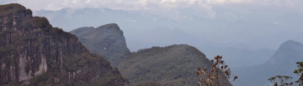
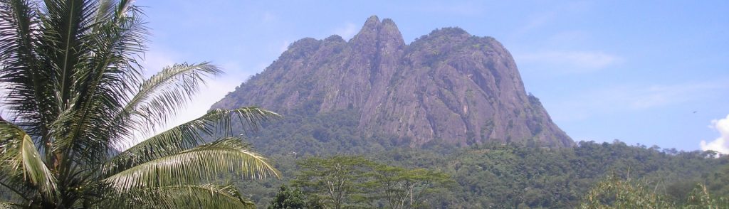
Gunung Parang is one of the most interesting peaks in Java. Despite being clearly visible as a jagged rocky ridge from the Jakarta-Bandung toll road, up until recently it was something of a secret, generally known only to Indonesian rock climbers. From some angles it very closely resembles the famous and unusual Scottish mountain Suilven. By 2017, things have changed and this fabulous and accessible mountain is finally getting the recognition it deserves.

Parang Read More »

Fatu Timau

Fatu Timau is a beautiful little mountain that appears pyramid-shaped from many angles. It’s one of the easiest Ribus to bag as its only about 400 metres from the carpark to the summit. Unlike most mountains in Indonesia, that are volcanic, mountains in Timor are non-volcanic. Few foreigners and even locals visit this area so don’t be surprised if they are bemused to see you!

Fatu Timau Read More »

Awu

Facts Elevation: 1,340 m (4,396 ft) Prominence: 1,340 m Ribu category: Kurang Tinggi Province: Sulawesi Utara (North Sulawesi) Google Earth: kml Rating: Other names: none. Eruptions: 1646, 1711, 1812, 1856, 1875, 1883, 1885, 1892-93, 1913, 1921-22, 1930-31, 1966, 1968, 1992, 2004 Photos Bagging It! Mount Awu is a volcano which dominates the northern part of

Awu Read More »

Daik

Facts Elevation: 1,165 m (3,822 ft) Prominence: 1,165 m Ribu category: Kurang Tinggi Province: Kepulauan Riau (Riau Islands) Google Earth: kml Rating: Other names: none Photos Bagging It! Gunung Daik is the highest point of Lingga island off the east coast of Sumatra. It is a very striking mountain, with two jagged peaks and a

Daik Read More »

Batikap

Facts Elevation: 1,580 m (5,184 ft) Prominence: 491 m Ribu category: Spesial Province: Kalimantan Tengah (Central Kalimantan) Google Earth: kml Rating: Other names: Betikap Photos Bagging It! Bukit Batikap is one of the northernmost mountains in Central Kalimantan. In 2012, as part of a mapping project with Tumbang Tohan, Heart of Borneo followed three village

Batikap Read More »

Talakmau

Facts Elevation: 2,919 m (9,577 ft) Prominence: 2,329 m Ribu category: Tinggi Sedang Province: Sumatera Barat (West Sumatra) Google Earth: kml Rating: Other names: Talamau, Ophir Photos Bagging It! The starting point for Talakmau (previously known as Mount Ophir in Dutch times and now spelt simply ‘Talamau’ by most local people) is the friendly village

Talakmau Read More »

Ijen (Merapi)

Facts Elevation: 2,803 m (9,196 ft) Prominence: 1,218 m Ribu category: Tinggi Sedang Province: Jawa Timur (East Java) Google Earth: kml Rating: Other names: none. Eruptions: Ijen 1796, 1817, 1917, 1936, 1952, 1993-94, 1999, 2002 Photos Bagging It! The Merapi-Ijen volcano complex lies within the much larger Ijen caldera on the eastern-most tip of Java overlooking Banyuwangi, the

Ijen (Merapi) Read More »

Scroll to Top