
Facts
- Elevation: 930 m (3,051 ft)
- Prominence: 369 m
- Peak category:
 Spesial
 - Province:
 Jawa Barat (West Java)
 - Coordinates: -6.5948, 107.3456
- Rating:

 (8 votes) Add your rating
 Loading...
Photos


Bagging It!
Gunung Parang is one of the most interesting peaks in Java. Despite being clearly visible as a jagged rocky ridge from the Jakarta-Bandung toll road, up until recently it was something of a secret, generally known only to Indonesian rock climbers. From some angles it very closely resembles the famous and unusual Scottish mountain Suilven. By 2017, things have changed and this fabulous and accessible mountain is finally getting the recognition it deserves.
The mountain lies to the east of the large Jatiluhur reservoir near Purwakarta. From Purwakarta, which is a mere hour or 90 minutes by car/bus from Jakarta) it takes about an hour to travel the 20km or so through delightful countryside and tiny villages. Most people in the area will be able to point you in the right direction but if in doubt, ask for Sukatani, Sukamaju, Tajursindang, Sindanglaya and finally Pasangrahan where the trail starts.
As the road snakes down between the mountains, the first sight you will get of Parang close-up is pretty astounding – it appears as a huge impenetrable vertical andesite cliff. From this side it certainly is impenetrable and it is only roped rock climbers that attempt to scale the mountain from any route other than the one described below. Interestingly, this area of vertical rocky peaks is very poorly represented in Google Earth – perhaps due to its unusual complexity.
Eventually, you will reach a village (‘Pasangrahan’) on the west of the peak where the trail to the summit begins (at roughly 423m above sea level). Opposite the tiny village shop are a couple of small buildings where you are requested to sign before climbing the mountain. The trailhead is clearly marked with a sign so finding the correct starting point should be no problem. Additionally, a neighbouring and equally imposing peak, Gunung Bongkok (‘the hunchback’), lies directly ahead (south west) along the village track.
You can easily climb the mountain alone as the trail is very well marked but if you haven’t been before locals will recommend that you take a guide (for just Rp 100,000). Unsurprisingly, the short hike to the summit ridge is relentlessly steep and incredibly hot. Make sure you take plenty of water. As you quickly gain elevation, the large Jatiluhur reservoir is revealed, with the forested flat top of Gunung Sangga Buana behind to the west and a smaller peak in the foreground, Gunung Lembu.
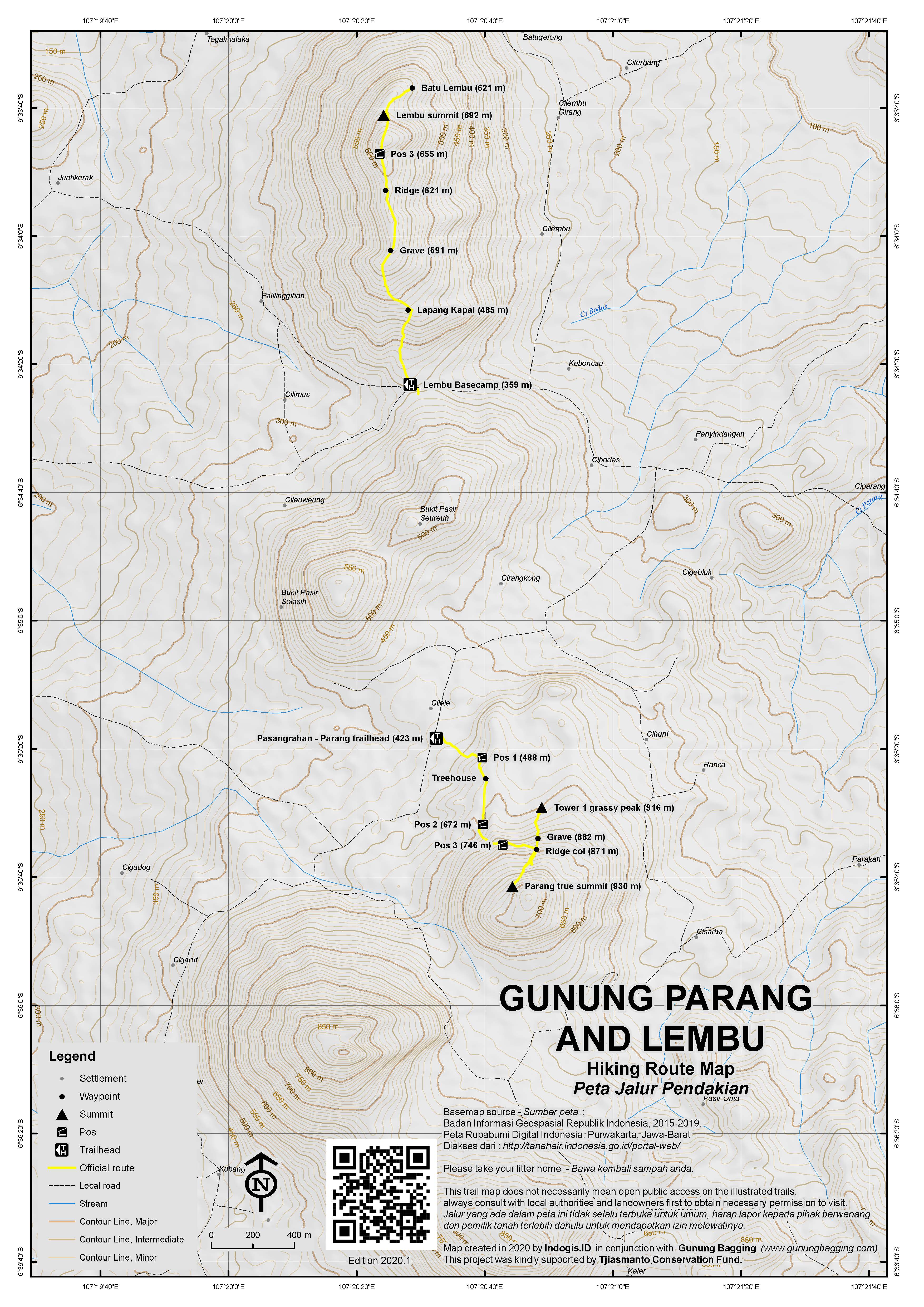
The trail is in good condition and straightforward other than couple of sections where you will need to use your hands to negotiate some large and slippery rocks. There are several pleasant huts to take a rest in – Pos 1 (488m), Treehouse (550m), Pos 2 (672m) and Pos 3 (746m). Most impressive of all are the treehouses at 550m. There are two very short side trails leading to boulders near both Pos 2 and 3 with good viewpoints to the villages below.Between Pos 2 and 3 is a view to the right of a vertical cliff with ropes still hanging from it left by a Dutch rock climber.
Most people can reach the Parang ridge (871m) in just over one hour and 15 minues. Here you can turn left for excellent views from ‘Tower 1’, or right into dense undergrowth and the true highpoint of the ridge. 99% of hikers opt for the former, and as such it will be described first below!
There is a small pile of stones (ancient grave, 882m) and impressive views to a narrow grassy peak (Tower 1) on the ridge just a hundred metres to the north (left). To reach this grassy peak (916m), descend beyond the ancient grave before ascending steeply up the grassy and bouldery top with sheer drops on either side on the trail. It only takes 15 minutes and suddenly, the view opens out all around you. For a mountain in West Java of less than 1000m, few come more impressive than this. The vast reservoir, numerous villages, plus other shapely peaks in all directions – most notably a slightly higher forested peak at the southern end of the ridge and the equally fabulous Gunung Bongkok a mile or so beyond. In clear weather, Gede-Pangrango and Ciremai are both visible.
Gunung Parang is Indonesian for ‘Machete Mountain’ and to reach the absolute highest point (930m, rarely visited by humans) you may need a machete! From the main junction on the ridge near the grave, head right into the dense undergrowth (preferably with a machete-wielding local guide). It is only 200 metres in distance to reach the true summit but it may take you 20 minutes or more to get there, depending on if the trail is overgrown or not (it probably will be!) The true highpoint offers limited views back to Tower 1 and potentially views over to Sanggabuana and Bongkok. The summit is marked (in 2017) with a small black string on an upright tree next to a fallen tree. Congratulations if you made it here!
The lower Gunung Lembu is also worth visiting in this area – perhaps third most interesting after Parang and Bongkok. It is also definitely worth visiting the Jatiluhur reservoir for a stroll, to take a few pictures of Parang’s striking shape from a distance and enjoy freshly caught fish. From Pasangrahan you will probably need an ojek but from the reservoir there are frequent angkots heading into both Purwakarta and Cikampek where you can catch a bus back to Jakarta (usually to Kampung Rambutan bus terminal).
A fantastic day out from Jakarta – just remember to set out early to beat the mid-day sun!
Gunung Lembu (692m).
One of the more prominent hills you can see from the top of both Parang and Bongkok is Gunung Lembu, the third-most interesting peak in the area. Not surprisingly the views from Lembu to Parang and Bongkok are excellent. It makes a decent half-day out from Jakarta (if you set out early enough to beat the usual traffic issues). Follow directions as below for Parang but instead of turning left to head to Parang and Bongkok continue for a further kilometre to the village of Panyindangan (359m). There is a car-parking place (Rp10,000) opposite the decent basecamp. Entrance ticket is Rp10,000. The hike itself can be completed in a total of about 3 hours, including plenty of time to take photos and rest etc. Fast hikers could reach the summit in under an hour. Guides not necessary as very popular with locals who camp up there in large numbers.
From the basecamp it takes about 15 minutes up to Lapang Kapal (485m) where there are a couple of warungs and a bamboo structure you can climb for great views. Another warung follows at 500m before you reach the start of the ridge at a grave at 591m. There is yet another warung at about 621m and an ancient grave before the ridge drops down before rising back up to Pos 3 (655m) after a rock and a view to the right. The summit (692m) is a large boulder to the left of the trail and near a popular camping spot. Be very careful on this boulder! Ignore the signs that say the true height is 792m – this is not the case.
Perhaps the best part of the hike is actually beyond the summit. Drop down about 70m (5 minutes or so) beyond a huge boulder and some bamboo shelters to ‘Batu Lembu’ (621m) – a very large rock offering great views in almost all directions (including over Jatiluhur Reservoir and to Parang and Bongkok). There is a simple metal fence around the rock and a rope to drop down onto the rock but be extremely careful. Watch out for the many monkeys that scavenge here!
Bagging information by Daniel Quinn (last updated June 2017)
Trail Map
For a high quality PDF version of this and other trail maps, please download from our Trail Maps page.
Practicalities
- Getting there: For domestic flights from or to West Java, such as the airport in Bandung, we recommend Baolau. From Jakarta, take the toll road from Jakarta to Bandung and exit at Jatiluhur (preferably) or Purwakarta. The are frequent buses to Purwakarta from Jakarta’s Kampung Rambutan bus terminal. If using public transport, either find a willing ojek driver in Purwakarta or take an angkot to Plered and an ojek from Plered to the foot of the mountain. If driving, it is less than 20km from Purwakarta to the mountain – head to Sukatani then turn right near the sign for the quarry and follow the road over the railway line and through Sukamaju, Tajursindang and Sindanglaya, after which you need to turn left (small wooden signpost for Gn Parang and Gn Bongkok) then right to Pasangrahan.
- Guides and GPS Tracks: Want a PDF version for your phone? Looking for a guide? Need GPS tracks and waypoints? Gunung Parang information pack can be downloaded here.
- Trip planning assistance: Would you like Gunung Bagging to personally help you in arranging your whole trip? Please contact us here.
- Permits: None required but take a photocopy of your passport photo page just incase. Sign the visitor book in Pasangrahan before climbing. Locals are asked to pay Rp10,000 per person and foreign tourists are asked to pay Rp25,000. Local guide – if you need one – costs Rp100,000 (in 2017).
- Water sources: Very limited and weather dependent – so take sufficient supplies with you.
- Accommodation: Try the Booking.com map above or use this link to search for suitable hotels, homestays, resorts and apartments for your trip.
- We recommend Safety Wing as travel insurance for overseas travellers and tourists hiking up to elevations not exceeding 4500 metres.
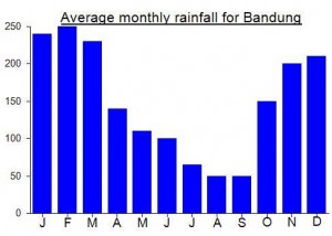
Local Average Monthly Rainfall (mm):
Location
Click on the blue arrow ![]() (top right) to see your current location on the map
(top right) to see your current location on the map
Origins and Meaning
Literally ‘machete mountain’ in Indonesian. This is obviously due to its appearance – the sheer, vertical andesite cliffs appearing as the blade of a knife.
Had an excellent half-day out today on Gunung Lembu – a very popular little hill near Parang and Bongkok. Setting off at 4am from Jakarta meant we were at the foot of the mountain by 6.30am and ready to start the hike at about 7am. A bit hazy as is often the case but still some brilliant views back to Gunung Parang and Bongkok and friendly warungs with snacks and drinks (including kelapa muda) making this a very straightforward hike. Lots of local student hikers.
My co-hiker lost his GPS over the edge of Batu Lembu! Take real care as the drops are vertical.
Perhaps not worthy of its own page but certainly worth including the information here as it’s a decent hill to explore in a great area not too far from both Jakarta and Bandung.
Hanging hotel coming soon to Mount Parang…. http://www.thejakartapost.com/travel/2017/07/07/hanging-hotel-coming-soon-to-mount-parang-purwakarta.html
After my recent revisits to mountains in Java that were relatively unknown when I first climbed them (e.g Butak) I was very intrigued as to how different old favourite Gunung Parang would be – a fabulous rock ridge not far from both Bandung and Jakarta which was only really known to keen rock climbers and a select few hikers five years ago. Whereas back in 2011 an online search for Gunung Parang would only bring up this very page plus a couple of accounts from rock climbers, now you’ll see tens of pages of information including on local homestays and challenging rock climbing options e.g via ferrata.
Well, it is certainly a little different now, more popular, but mostly in a positive way. The friendly, fit and knowledgeable Pak Wahyudin was sat in the hut at the well signposted trailhead and was more than happy to accompany me up onto the mountain. He had a machete with him which bode well for my aim of finally reaching the true highpoint of the ridge which is very overgrown indeed and rarely visited (except by wild pigs).
There are now several ‘Pos’ on the short trail and at each is a basic but attractive shelter, and in a couple of instances treehouses to rest in! There are also a couple of side tracks near the Pos to large boulders with flags near them and expansive views. Much of the way is marked with bamboo poles to hold onto and from one point on the trail you can see several ropes tied to a nearby vertical cliff, apparently used by a Dutch rock climbing expert recently. There’s a landslide area just before gaining the ridge (happened in 2016) but nothing that prevents progress. According to Pak Wahyudin, a couple of Djarum (local cigarette) adverts were filmed here on Gunung Parang in the last couple of years!
Once we reached the ridge I persuaded him to head right and into the undergrowth! Pak was well up for it and with a bit of machete work we made it to the top of the ridge in just 20 minutes or so. The true summit of Gunung Parang. You could do it in 10 or less now, though obviously it will be overgrown again in just a few weeks! There is a fallen tree at the top, and you might glimpse some views in clear weather of Sanggabuana and Bongkok but it was very hazy for our visit. Having already left a shirt at Gunung Malang the previous day, I could only really give a shoelace/black string thing to this mountain to mark the highest point, so I tied it to an upright tree for anyone else that cares to come this way again soon! GPS gave a highest reading of 939m, which means the 915 is almost certainly an underestimate. 930m might be more appropriate…….
We were back down at the junction in less than 10 minutes. I expected Pak Wahyudin to want to head straight back down to the village but he was keen to go onward to the grassy peak at the other side of the ridge (now more commonly known as ‘Tower 1’) so onward we went. The mountain remains pretty clean considering how popular it can be, so well done to the local community and hikers for encouraging this responsible behaviour. There’s even a sign to tell hikers not to smoke on Tower 1 (due to the risk of forest fire).
At the grassy peak we took it easy for a while (during which time a large black flying ant of some sort bit me – 3 days later and the red mark is only just now receding!) We were back down at the village in a leisurely hour (after I got changed in one of the lovely treehouses) and I hopped on my ojek back to Purwakarta and bus to Kampung Rambutan, Jakarta. Great stuff. Maybe I’ll head back to hike little Gunung Lembu later this year for a different perspective on Parang and Bongkok…..
Does anybody know anything about the rock climbin on Tebing Parang?
There’s definitely a lot of climbing on Parang. Unfortunately the last time I was there was 1988 (did a 2 week siege of the west wall to establish the first route on that side). But there are more quality routes on the other side. Try checking in with Indonesian climbing orgs (ie. skygers) for more info….
We just climbed Gunung Parang yesterday and had a great hike. Left Jakarta at 5.30am and started the hike at 9am. As we asked directions along the way, we picked up a couple of local guys as guides – which was a good thing as one girl in our 7-person group needed a lot of helping getting down on the steep, slippery path.
It took us 1 hour and 15 minutes to get to the grassy summit and had a great time getting there! What a fun trail to go up. Going down was slower than going up – mostly due to the fact that we were in no rush and really wanted to take our time.
We had to pay a fee of Rp 15,000 per person at the Post at the trail head. No one else has mentioned this yet – did anyone else get shown an official looking letter stating this fee?
Overall, great hike and highly recommended, though it’s a short hike considering all the driving involved. Note that, while the road was rough, we had rented a 11 seater Golden Bird mini bus from Blue Bird which got us all the way there (although the driver made a few huffing noises along the way when the road got rough).
re car access to Pasanggrahan. We came from Jakarta and took the Jatiluhur toll road exit. From here you can head up the old road toward Plered and Bandung. After Sukatani and about 2km before the Plered turnoff there is a road to the right signed to Gunung Kecapi Andesite Quarry. Follow this road for about 15km through the villages of Sukamaju, Tajursindang and Sindanglaya to get to Pasanggrahan (it’s on map D4 in the Falk Jakarta Street Atlas). This road is mostly well-surfaced and an easy second/third gear drive in our Kijang. Only the last two km into Pasanggrahan is a bit rough and mostly first gear.
re the walk. We walked without a guide and routefinding was pretty easy once you have found the start point behind the kantor desa. Just bear right when you reach the rock face. We started at 8.30 at an easygoing pace and reached the north summit at 10.30. Not too hot and shaded all the way except for the final push up to the grassy knoll. The trail was dry, so with good shoes and two free hands there were no real difficulties. Gede and Pangrango were visible but Ciremai lost in the haze. 90 minutes to descend.
Thanks Dan for the info- the views are truly spectacular considering how short this hike is!
Just back from a camping trip to Parang. Quite an experience! 3 of us, of whom 1 had to descend straightaway in order to get back down before nightfall. It’s tough enough hiking up the steep trail to the narrow summit ridge in normal conditions, but with huge backpacks it was totally exhausting. It took us just over 2 hours to reach the lovely grassy peak with 360 degree views – easily one the best views in West Java. Muryanto headed straight back down to Pasangrahan and reached the village in just 50 minutes!
I had forgotten just how bouldery and narrow the grassy area is – which means sleeping in a very awkward position with 500 metre cliff faces just a couple of metres away in all directions! Still, the views were pretty spectacular. Darkness fell and we went into our tents – within an hour or so a storm began, with thunder and lightning very close by. Pretty terrifying – especially as a first experience of camping in Indonesia for my companion! My tent more or less collapsed in the gusts of wind and I was reduced to soaking up the rainwater with my sleeping bag. When morning came, we were just happy to have survived!
After taking photos of the phenomenal panorama of peaks and the immense Jatiluhur reservoir, we attempted to head towards the true highest peak of Parang (which is covered in dense jungle) but the density was just too much though we got to within about 100 metres of the highest point.
Given how exhausted we were, the long-planned ascent of Bongkok has been postponed until later in the year.
wow that’s my grandmother’s village in there ^^
No I don’t remember seeing a trail to the right it was heavily forested. Maybe some offshoots from the trail but they ended after 5-10m or so. FYI the pile of stones on the grassy peak is a ‘makam’ or grave of a spiritual protector of Parang from a long time ago – sort of a Mbah Maridjan equivalent for the area (!).
Menarik sekali. Had he been around today, I wonder if Mbah Parang would have been a Kuku Bima type of chap….
Just did this trip the other day – thanks for the accurate info! I followed the ‘getting there’ section carefully and was there with no problems. On a Sunday, departing from Kampung Rambutan at 7am, I started the climb at 10am, on the ridge by 11.30, the grassy summit by 12.00, and finally all the way down by 2. All with breaks included. A great trip out from Jakarta, highly recommended! The trail is still pretty fresh and we went the night after a rainstorm so needless to say I was slipping all over the place (!)..watch your step.
Good stuff – I’m going to try Parang’s nextdoor neighbour Bongkok next month. Another cracker by the looks of it. Don’t suppose you noticed a trail on Parang to the highest point (turning right on the ridge instead of left to the grassy peak)? I may well go back and have a look but can’t remember if there is even a trail heading right…
Well done Mr. Daniel.
I really appreciate you taking the initiative to research and explore that mountain.
I agree that it has a mystical feel to it. It seems like something out of science fiction novel when you pass by it on the toll road.
Looks like a great way to spend a day out of Jakarta and make it back in the same day! well done
Dear Freinds,
We plan to hike Prang on 12 February. We will go from Jakarta. Can any one kindly share some tips, as what items, gears etc we should take with us. Also if you have any map or detailed route from Jakarta to the place. We have rough idea how to get there, but it will be good to have a map or more specific information.
Thank you in advance.
Best Wishes.
Muhammad Asif, Jakarta
The above information is pretty accurate. If you’re taking public buses then getting out at Purwakarta and taking a microlet to Plered and ojek to Parang is simple enough. You’ll be at Parang from Kampung Rambutan in about 3 hours. If you’re taking a car you might need to ask for directions. Don’t take anything but a Kijang or 4×4 because the road from Plered to Parang can be rough, steep + bumpy. For gear then normal hiking material is OK. Watch out because it is very steep and can be slippery if it rained the previous night. Straightforward 3 hour hike up and down at good, relaxed pace. Enjoy!