
Facts
- Elevation: 985 m (3,232 ft)
- Prominence: 717 m
- Peak category:
 Spesial
 - Province:
 Jawa Barat (West Java)
 - Coordinates: -6.6016, 107.3374
- Rating:

 (10 votes) Add your rating
 Loading...
 - Other names: Bangkok (mistake on some maps)
Photos
")
")
")
")
")
")
")
")
")
")
")
")
")
")
")
")
")
")
")
")
")
")
")
")
")
")
")
")
")
")
")
")
")
")
")
")
")
")
")
")
")
")
")
")
")
")
")
")
")
")
")
")
")
")
")
")
 and Gunung Parang (right) as seen from the KM97 service station on the Bandung toll road (Daniel Quinn, November 2012)")
")
")
")
")
")
")
")
")
")
")
")
")
")
")
")
")
")
")
")
")
")
")
")
")
")
")
")
")
")
")
")
")
")
")
")
")
")
")
")
")
")
")
")
")
")
")
")
")
")
")
")
")
")
")
Bagging It!
The steep and impressive Gunung Bongkok (sometimes mis-spelt ‘Bangkok’) lies just to the south of the equally imposing Gunung Parang. They are both of great interest to rock climbers as there are various vertical rock faces on their slopes. This lovely area can easily be explored on a day-trip from Jakarta.
In previous years, neither Bongkok nor Parang was often visited except by local villagers and occasional student hikers but by 2020 both are popular places for weekend trips and there are even local tourism signs from many kilometres away. Both peaks are stunning, and my 2011 prediction that it must surely only be a matter of time before these mountains become much more well-known has already come true.
Both peaks lie to the east of the large Jatiluhur reservoir near Purwakarta. The starting point for Gunung Bongkok is Sukamulya (or lesson commonly Cisarua), which is best accessed via Plered because the small farm roads from Purwakarta are incredibly bumpy and rocky and it would take at least 20 minutes just to get from Pasangrahan (starting point for Parang) to Sukamulya or Cisarua. Local roads have been improved in recent years and it now takes just over 1 hour from Purwakarta.
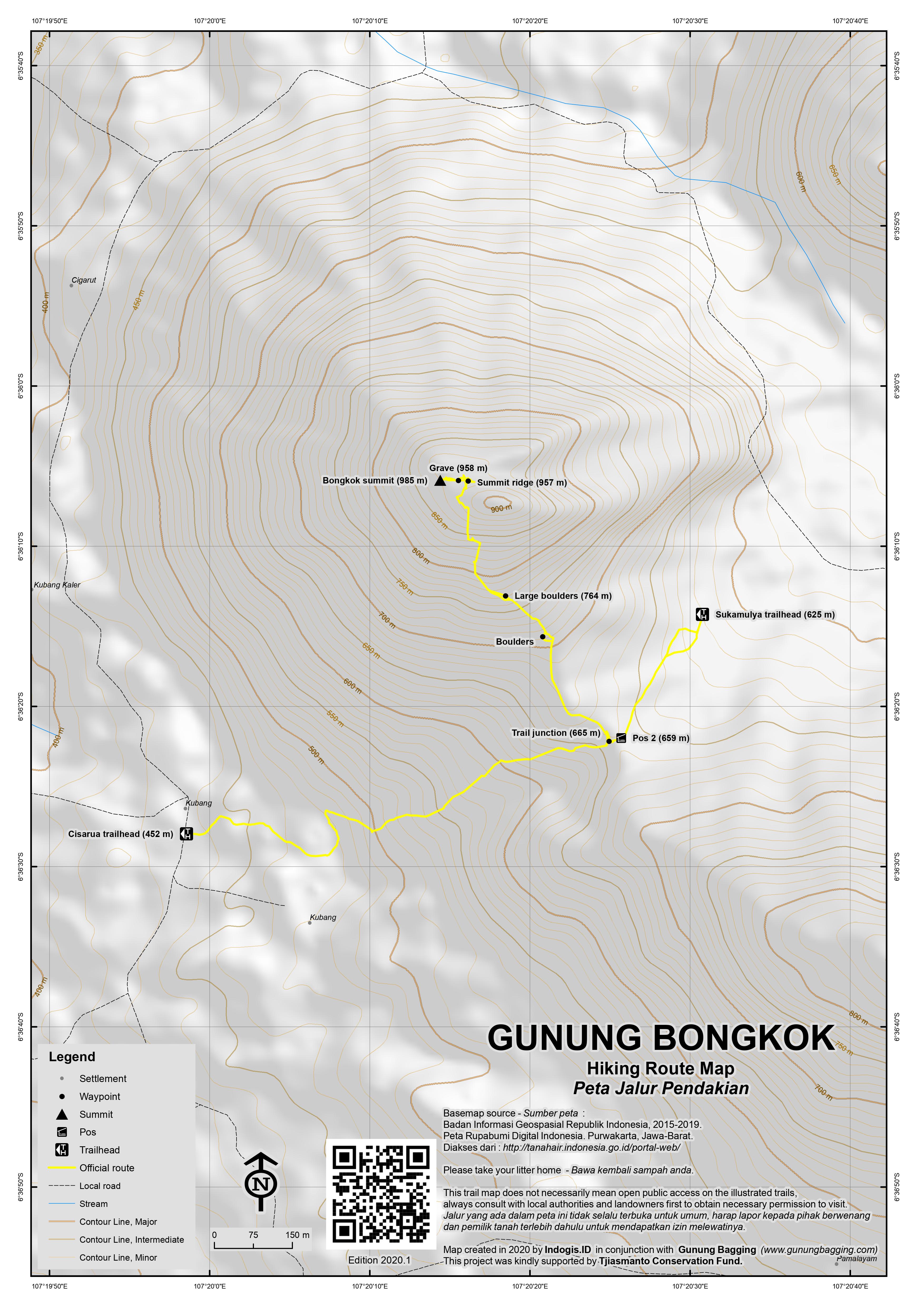
Sukamulya route
The Sukamulya trail starts at the end of the road beyond SMPN 2 Tegalwaru (Middle School). In 2020, there are already 2 warungs selling drinks and snacks, a simple toilet block, and work is underway to add another building. The view back down the road towards Gunung Parang is impressive and the trailhead is at an elevation of 625m above sea level. It is only 360 metres or so of ascent to reach the summit which takes most hikers between 1 hour and 90 minutes up and a similar amount of time to descend again.
Follow the stone path as it leads up the hillside. Soon you will have reached the ridge at Pos 2 (659m) which is a very pleasant area with a lovely little building and a bamboo walkway viewpoint overlooking the southern end of Jatiluhur reservoir on the other side of the mountain. You can also see the less popular path coming up from the other side at Cisarua (see below for details).
From Pos 2, take a right. The area is full of bamboo and occasional large boulders. Some of these boulders would provide shelter in the event of heavy rain. The trail soon gets much steeper and there are several rather tricky places where you will need to use both hands to ascend/descend large rocks (764m) and steep muddy areas. Thankfully there are ropes which will assist you in this. After 770m the bamboo gives way to other vegetation. There is not much of a view here because of the trees, but think of this as a blessing because it would be oppressively hot outside the shade.
Soon you will reach the true summit ridge (957m), where you turn left, pass the site of an ancient grave (seen in 2011 but not in 2020) and then finally spot the summit boulders of this superb mountain.
Because of the size of the boulders, the highest of which is called Batu Tumpuk, no trees can grow at the top of the mountain and so the views are absolutely stunning – the vastness of the Jatiluhur reservoir below, the phenomenal shape of neighbouring Gunung Parang, the vertical drops back down to the villages and the holy mountain of Gunung Sangga Buana on the other side of the reservoir. It is truly breathtaking – perhaps the finest view within 100 kilometres of Jakarta.
The boulders are easily climbed so – unlike the densely vegetated Gunung Parang – Bongkok can be bagged very easily. Do take great care however because a fall here would mean falling several hundred metres down the cliff face of the mountain. There is much animal life here – swallows love to swoop round the peak and in sunny conditions you will probably be able to see a few eagles soaring below you. There are also a number of flying ants so make sure to check for them every few minutes.
After enjoying an hour or two in the shade of the huge boulders, simply follow the trail back down to Sukamulya. Because of a few steep, difficult sections of the trail, allow a similar amount of time to descend as to ascend.
Cisarua route
In 2020, the Sukamulya route is by far the most popular one, but the mountain can also be climbed from Cisarua on the west side of the mountain. In Cisarua, there is a small warung where a couple of vehicles can be left. The local people are very friendly and would be more than willing to guide you to the top for a very modest fee. Cisarua is at an elevation of approximately 452m so it’s just 520 metres of ascent to reach the top, which can easily be done in 2 hours by most fit people.
There is a new track leading up from Cisarua towards the mountain itself. From here, in good weather you will be able to spot the huge glistening andesite boulders which crown the peak of Bongkok.
The farm trail leads up the hillside and follows a pleasant grassy strip for some distance. It’s a beautiful area – mango trees, cattle roaming freely and great views back down towards the huge reservoir.
After about 30 minutes of fairly standard upland farm hiking, you will reach Pos 2 at the crest of the hill (665m) and this is where you meet the more popular route up from Sulkamulya and where you must turn left onto the shoulder of the mountain.
Follow the description above to reach the peak and allow around 2 hours or less to descend.
Bagging information by Daniel Quinn (June 2011, updated October 2020).
Trail Map
For a high quality PDF version of this and other trail maps, please download from our Trail Maps page.
Practicalities
- Getting there: For domestic flights from or to West Java, such as the airport in Bandung, we recommend Baolau. From Jakarta, take the toll road from Jakarta to Bandung and exit at Jatiluhur or Purwakarta. The are frequent buses to Purwakarta from Jakarta’s Kampung Rambutan bus terminal. If using public transport, either find a willing ojek driver in Purwakarta or take an angkot to Plered and an ojek from Plered to the foot of the mountain. If driving, it is around 25km from Purwakarta to the mountain – there are various possible routes of differing road surface quality so best consult an App for the quickest one.
- Guides and GPS Tracks: Want a PDF version for your phone? Looking for a guide? Need GPS tracks and waypoints? Gunung Bongkok information pack can be downloaded here.
- Trip planning assistance: Would you like Gunung Bagging to personally help you in arranging your whole trip? Please contact us here.
- Permits: Register at the Sukamulya basecamp trailhead and pay the small fee of around Rp12,000 per hiker.
- Water sources: None on the mountain. There are small warungs in Cisarua, Sukamulya and nearby villages below the peak but take sufficient supplies with you.
- Accommodation: Try the Booking.com map above or use this link to search for suitable hotels, homestays, resorts and apartments for your trip.
- We recommend Safety Wing as travel insurance for overseas travellers and tourists hiking up to elevations not exceeding 4500 metres.
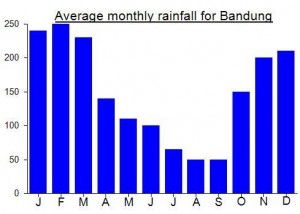
Local Average Monthly Rainfall (mm):
Location
Click on the blue arrow ![]() (top right) to see your current location on the map
(top right) to see your current location on the map
Origins and Meaning
Hunchback Mountain. Bongkok means “hunched” and is used here describing the shape/appearance of the mountain. (George Quinn, 2011)
After a nine-year gap, made a second visit to Gunung Bongkok earlier this week. Caught the Serayu economy train from Pasar Senen – very quiet, only 4 passengers in the same carriage as me, presumably because you can just jump on a bus without having to get a rapidtest but interprovincial trains require them. Only 90 minutes to Purwakarta. Plered is closer to the mountain but the train only calls at Plered on the way into Jakarta. But if you have the option, get off at Plered instead.
There are several signs on the man road for both Parang and Bongkok now, signs with a colour photo and some words about the mountains.
At the basecamp / trailhead in Sukamulya it was quiet, but it was midnight and not a weekend (which are usually very busy, and best avoided if you like solitude and not having to do selfies every five minutes). The man in charge of the warung on the right looked at me as if he had seen an apparition, a Pocong Belanda perhaps. He certainly couldn’t believe his eyes as a foreigner arrived at his warung at midnight and asked for a coffee. Very nice guy anyway, and 3 coffees later were we ready to start the hike.
Being already up at 625m, this is a much easier route than the one I did the first time from Cisarua, a lower down village and no proper trail, cutting across fields. But at Sukamulya this is a proper little village industry now.
We were at the top in about 1 hour and 10 minutes, going reasonably leisurely. The sound up there was incredible – thousands and thousands of frogs in the fields down below. A frog chorus with tens of thousands of participants.
Sadly, there were also several hundred flying ants, ants that actually bite. Not pleasant! This wasn’t much of a problem at 3am, but by first light just after 5am as we sat waiting patiently for sunrise, they really got active!
The view was superb – it’s a view you don’t forget and perhaps the best one within 100km of Jakarta. Just panoramic.
You could easily do this without a guide now from the Sukamulya side, but best don’t hike alone.
Back in Purwakarta I got on a Warga Baru bus to Kampung Rambutan – Rp50,000, about 90 minutes plus 30 tedious minutes waiting near the Sadang toll road entrance for more passengers.
Dan this is a very late reply to your MSG end of 2011, however reference my uncles plane crash the RAF have sent me a little more detail of the location site which doesn’t give an exact grid but their details say, location is latitude longitude, 06- 26′ Suoth, 107- 14′ East, 30 miles NNW of Bandoeng, ( Bandung ). Going to Aus in June for 4 wks will watch some Lions matches and at the same time plan a trip to Indonesia . All for now Stan
Climbed bongkok today (actually thinking it was parang, so we were a little surprised to have the guide point out parang to the right of where we were standing when we were on the puncat of what we thought was parang…a very awkward conversation followed).
The roads have been repaired and are easy to drive and the parking area is now a fish farm with v friendly locals. And a good toilet and mandi.
Guide is essential as there is now barbed wire to get through the farm land. The guide will know which section can be pried open.
Did the drive to and from in 3 hrs from jaks. Got the guide at the fish farm.
Just bagged Bongkok-Parang last week end.. Superb! we camped on top of Bongkok, then continue to Parang in the following day. In Bongkok, it wasn’t too comfort for camping bc of the boulders, but we enjoyed it very much. Accidentally we took different village from you, Dan..which i suppose it’s quicker. Then the trek will join at ‘turn here’ waypoint (refer to your Bongkok GPS trek). Thanks for your recommendations for my ‘no week end without mountain’ program 🙂 cheers
It’s nice to see Gn. Bongkok again.
Back in the late 80’s me and some schoolfriends set up some climbing routes. I went up there from jkt 5/6 times. Always on the rockface and never on the top really. One day I’ll return there, from Europe and will finish one route to the Top.
As I spent many climbing hours on Bongkok and Parang, I can say that the rock isn’t Granite though, but Andesite.
Greetings from the Netherlands,
Michel
re car access. From Jakarta, take the toll road to Bandung and exit at Jatilihur. Take the old road up toward Bandung and turn right to Plered (see Falk Jakarta Street Atlas map D4). Continue along the main road westward beyond Plered; about 9km after the market is a junction with a large tamarind tree and a turning to the right that will take you to Tegalsari and Cisarua. (Ask directions carefully as there is another village called Cisarua east of Gunung Bongkok; there are at least two Batutumpangs, and “Tegalwaru” could be anywhere in the district.) The Cisarua road is a well-surfaced rubber plantation road- only the last few hundred meters into Desa Cisarua are rutted. It’s about 7km from the junction to the warung in Cisarua.
(Pasanggrahan, the starting point for Gunung Parang, is about 4km beyond Cisarua along the same road. However, that section of road looks very rough. Access to Gunung Parang is probably better via the road I describe on the Gunung Parang page, or you could just walk from Cisarua to Pasanggrahan.)
re the walk. We took two local boys as guides- definitely essential, as the lower slopes are criss-crossed by farmers’ and woodcutters’ trails; even our guides seemed confused at times! Two hours up and two hours down, as described by Dan. Our GPS reading at the top was 993m. According to our guides, the path up to the shoulder of the mountain continues beyond the summit turn-off to the village of Cikandang on the east side of the mountain. So it should be possible to start an ascent from the east side, though the access road is poorer than on the west side.
re safety. I slithered a couple of meters on the way down, but luckily without damage. Just stay alert- even the less steep parts can be treacherously slippery. In the rainy season, this walk must be tough. There are no vertical drop-offs except from the summit area and there’s enough room there to walk and clamber around comfortably.
If you want to climb both Parang and Bongkok, I recommend climbing Parang first, as it’s a more straightforward hike. Bongkok has slightly farther to ascend, the approach path is longer and rougher, and the steep part is unrelenting- and slippier! Also, the view from Bongkok gains added interest from looking across to Parang and finally being able to work out which of the various Parang peaks you were actually on and where the trail was that you used to climb it!
hi Dan,
these mountains seems so incredible and majestic. I wanted to ask if the trail going up bongkok was safe or if it was muddy and slippery with steep, plummeting drop offs? or was it the summit that we need to exercie the most caution. headin’ to bandung in a week and wanted to stop by and see these moutains for myself. thanks, Zachary
Hi Zac. The trail is pretty safe apart from a few big rocks you have to use both hands on. The top obviously has immense drops either side so ‘hati hati’… I’m sure you’ll have a great time – as you say both this and Parang really are ‘majestic’
We had a brilliant hike up this mountain on Sunday. It is one I had been planning to climb for some time, having already been up the excellent Gunung Parang which lies to the north. From some angles from the toll road to Bandung, both peaks appear as one long jagged ridge. Infact, whereas Parang is a fairly long ridge, Bongkok is really just one top, crowned with beautiful granite boulders. I have been a great fan of Parang since I first visited the area but I have to say that Bongkok is perhaps even better – perhaps the best daytrip hike that there is for those of us who live in Jakarta.
On Saturday afternoon we got the Argo Parahyangan train (bound for Bandung) and got off at Purwakarta (only some services stop here). On the Sunday morning we made our way through the crowds by Situ Buleud lake (commemorating the history of the city itself), met Muryanto – who lives in Purwakarta and is a keen wildlife and nature lover – and charted an angkot to take us to Cisarua. It was a rough journey because we took the usual route to the starting point for Parang and continued on along very bouldery roads. On several occasions we had to get out or let the driver make a repeated attempt on a particularly steep section of farm track.
Once in Cisarua, the local chaps hanging around at the warung were very keen to guide us and we must have had about 8 locals with us! They were great and obviously enjoyed an excuse to climb their local mountain again. The trail is in good condition and there is very little little indeed.
Once at the top, the locals erected a huge bamboo pole with some kind of vegetation on the top of it and put it up on the highest of the summit rocks. One of our group was relaxing in the shade of the summit rocks, enjoying the spectacular views below, when his phone slid down the boulder and off the edge of the cliff and down the mountain! You really do need to take care here – better a phone than a human being!
My GPS gave a reading of about 985m – 15 more than the Bakosurtanal figure. We’ll leave it for now but if other people get higher figures too then maybe we’ll update it.
On advice from the locals, when back down in the village and after a refreshing mandi,we headed in the opposite direction to Plered along much better surfaced roads. We were back in Puwakarta in about 90 minutes.
This is a hike I’d love to do again and again – a true gem. Thoroughly recommended.
Hi Dan
been reading the comments on the routes to mount bongkok as next year we are planning a trip to jakarta and then moving towards bandung from there we will stay in the area of bongkok the pictures are breath taking .in 1946 Jan 14th my uncles Dakota crashed in the mountain range of bongkok all were killed my intent is to locate the crash site all i know is that it crashed on high ground, thats what the crash report said however the RAF log book said it flew into a hillnear SANGGABODWANA? 30 mls N W of BANDOENG (BANDUNG)just sent this finding to scotland yard ;historical branch;hoping they can give me the 6 fig grid, as it happens there is a Name which sounds the same as SANGGABODWANA but that is the mountain range of SANGGABUANA which is the other side of the reservior of BONGKOK anyway im preparing this trip some time in May June 2012 looking forwards to see such brilliant sights as well as achieving my aim. all the best Stan
Hi Stan – thanks for your fascinating message. Yes I would definitely imagine that the crash site is in the larger and higher Sanggabuana range which as you say is to the west of Jatiluhur reservoir.
Have a read here https://www.gunungbagging.com/sangga-buana/
To get there, come off the toll road at Karawang and head south through the villages for 32km.
Please do let us know more as your research continues…
Very pleased to say that there is a route to the top of Gunung Bongkok. Masashi Wakagi and friends climbed it last weekend from Kampung Cisarua (west of the mountain)….. “We left Kp. Cisarua at 1200 and reached the top (rocks) of Bongkok at 1500 after 40 min. stop to avoid heavy rain. The route was clear, though steep and muddy with unsound stones after heavy rain. I used a rope for both up and down at the upper part in order to accelerate the speed for my friends. The top extended us with a excellent panoramic view of 360 deg. It took us 2 hrs for ascent and 2 hrs for descent net. If you are alone, it is enough for 3 hrs. to and fro.”
Went to have a look at possible access routes to this rarely-climbed peak at the weekend. Unfortunately nobody in the next village beyond Pasangrahan (the starting point for Parang) knew much about climbing it and said they rarely went up it and that it was very difficult terrain.
So, given the rather dull weather, I decided to just go for a wander on a farm trail between Parang and Bongkok and take a few photos of Jatiluhur reservoir below.
There is a possibility that there’s a route from the other side, near Cikandang, but the cliffs are pretty imposing and look rather impenetrable. I hope to return there early next year to try and find out more from the other side.