
Facts
- Elevation: 1,300 m (4,265 ft)
- Prominence: 829 m
- Peak category:
 Spesial
 - Province:
 Jawa Barat (West Java)
 - Coordinates: -6.5908, 107.2206
- Rating:

 (12 votes) Add your rating
 Loading...
Photos


Bagging It!
Gunung Sangga Buana is a small mountain 32km south of Karawang, popular with local villagers who often pray on its slopes. There is even a sign for the mountain just below Jembatan Badami (an hour from Jakarta on the bus route from Kampung Rambutan to Karawang).
The bumpy village road leads along the banks of the Badami river, through small villages, increasingly delightful West Java countryside and eventually up into the hills. One of the most interesting peaks is rocky little Rungking (630m) to the right of the road, which become visible a few kilometres before the trailhead.
Just like the nearby mountains east of the Jatiluhur reservoir, the area is fascinating and remarkably unknown given how close it is to Jakarta. Sangga Buana is by no means the only attraction in the area – there are numerous waterfalls and many local Indonesian students come to visit the more accessible ones at weekends. Curug Cikoealngkak (also known as Curug Bandung) and Curug Cigentis are particularly popular so early mornings or weekdays are best to avoid the crowds.
Back in 2010, Sangga Buana had its very own basecamp (141m) at Kampung Cipeuteuy. This used to be the place to register and find a guide prior to starting your hike but in 2020 the ticket booth and registration point is part of the way up the trail itself!
From Kampung Cipeuteuy the newly-surfaced roads leads another few kilometres into the base of the mountain range to Mekar Buana village (381m). This is the place to leave your motobike and start your hike, as continuing on the road will lead you closer to Curug Cigeuntis waterfall.
From Mekar Buana, follow the trailhead sign on the right past the village buildings and onto a farm track. You should almost immediately see a river below you on your right. The path leads up a clear well-used path through fields and there is very little shade so make sure you start early in the morning or cover up sufficiently and use suncream.
There are numerous wooden buildings on this early section of trail, ranging from very simple huts to rather ornate little houses. Many of them sell drinks and snacks to hikers and pilgrims, especially at weekends. The first and second huts are at 440m and 464m, followed by a couple of minor stream crossings.
A third and fourth building follow at 475m and 492m before higher up the fields you reach the proper entrance building (503m) where you can purchase a ticket (Rp10,000 per hiker in 2020), have a look at the trail map created in 2018, and probably be offered a coffee or snacks!
A little further on in coffee plantations is yet another hut/warung (at 509m) and some trail signs. This is an important junction (F3 – Persimpangan Puncak – Kebon Jambe), a straight on would lead you to Campground UBP Cigolosor (F4), Situs Kebon Jambe (F5) and Makom Pandai Domas (F6) but for the summit you must take a left.
A wooden mosque (521m) on the right side of the trail soon follows before the trail zig-zags up the hillside a little, following the edge of the ricefields.
Next is a collection of simple buildings – Komplek Ma Paraji Sakti (645m, formerly labelled Mbah Berang and F8 on the trail map) – coffee is prepared here, there is a small shop, a couple of graves, and local people come to pray and rest here. Sangga Buana is very much a mountain for local people to pray on.
The trail then crosses another open field and yet another warung (651m) before entering the forest (669m). Finally some shade! Soon the trail passes some large rocks and an obvious camping area near a small river (688m) complete with another warung and some simple toilets. You can also bathe in the river. This is F9 on the map and is labelled Pancuran Kejayaan and Campground.
From here you can actually choose from two trails that meet higher up before the summit. The less well-used and narrower trail leads straight up behind the camping area buildings and is much less preferred to the wider, gentler trail that snakes up the hillside further to the west, just beyond the stream and bathing area.
Assuming you follow the popular, more western, trail, you have a steep section to negotiate with a few tiny places suitable for one tent (at 836m and 1,039m). Then comes the most delightful part of the trek – a lovely ridge to wander along in delightful forest and at a near-perfect temperature.
Next, there is a rest area with a dilapidated bamboo shelter at 1,137m (stay left here) and then a prayer shelter labelled as F10 on the map at 1,194m. F10 is known as Makom 2 (Eyang Jagaraksa) as the shelter houses two graves. This is also where the lesser popular trail up from the campground joins up with the main trail but it may not be easy to see unless it has been used recently.
Soon after this the first summit (1,291m according to GPS and labelled F11 on the map) is reached. It should have taken no more than 3 hours to this point. This first (west) summit is actually home to a small community of about 15 or 20 people and there are several warungs where you can get a coffee, water and snacks. There are also several ancient piles of stones and graves dotted around, along with the usual flagpole and a simple mosque.
However, the highest point of the mountain (by about 10 metres only) is actually the narrower eastern summit which takes a further 15 minutes to reach via the trail which cuts through more coffee plantation and past another ancient grave (1,265m) and the col (1,246m) where you need to stay to the right rather than follow the wider trail as it drops further down.
This eastern, true peak is known as ‘Puncak 1’, presumably because it is higher than the western summit with warungs on it. Most visitors to Gunung Sangga Buana do not bother to visit Puncak 1 so the last bit of trail from one peak to the other may be a little overgrown, though if you are lucky with weather conditions you may be able to see Gunung Gede-Pangrango in the distance from halfway between the two tops.
Back in 2010 there were a few collapsed buildings here but in 2020 this has been cleared away to leave a very pleasant little spot to sit and rest for a few minutes. The Bakosurtanal map gives a height of 1,278m for the western summit and 1,279m for the eastern summit but these are both several metres too low. GPS readings suggest a height of around 1,300m for Puncak 1. There is another grave, more recent, and no less than three cement summit markers, one of which marks the boundary between Purwakarta and Bogor districts. There are also one or two hiking club signs here.
After a drink and a chat at the warungs back at the western top, it takes about 2 hours to descend the same way from a very memorable mountaintop.
Bagging information by Daniel Quinn (July 2010, updated in July 2020).
Trail Map
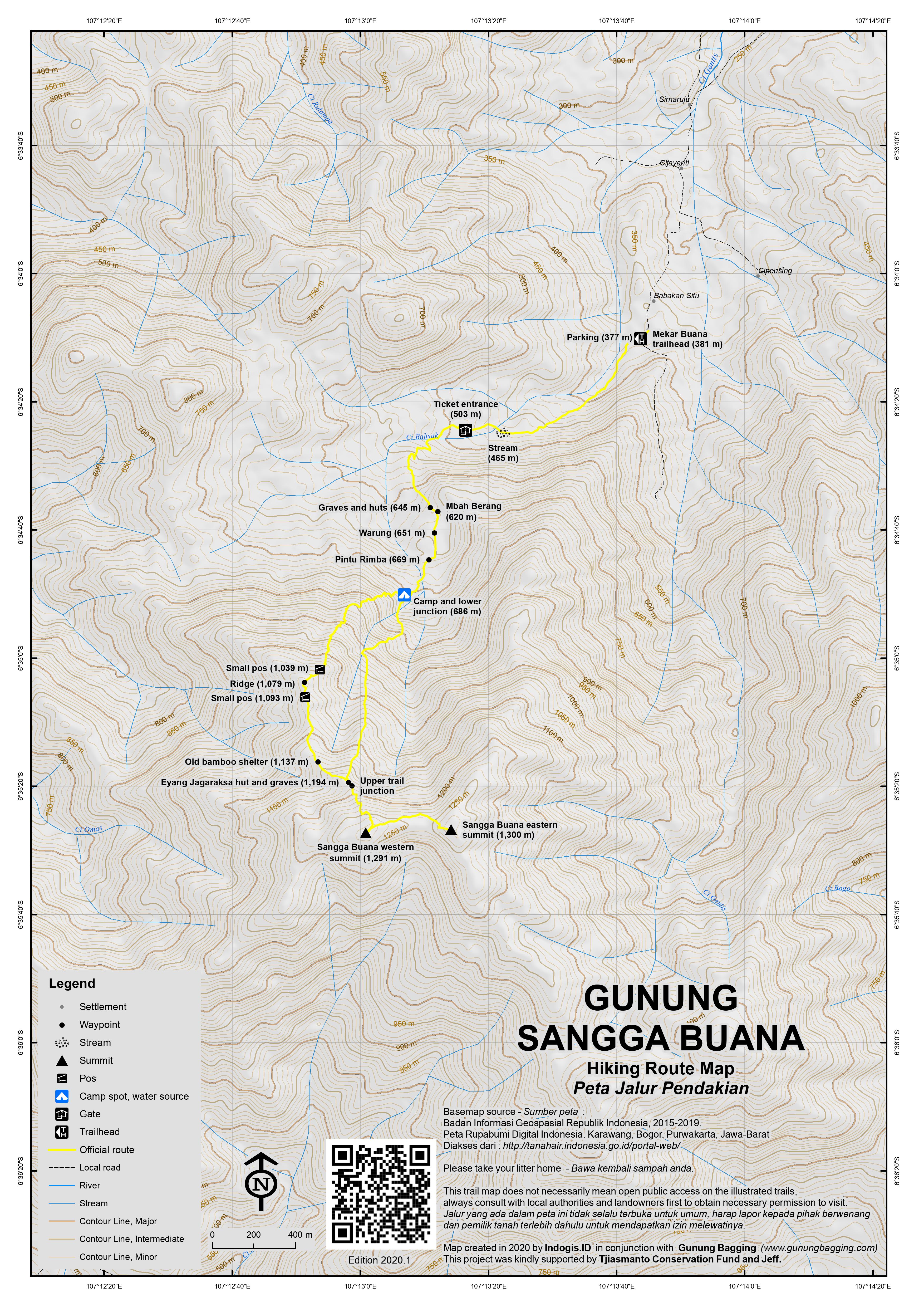
For a high quality PDF version of this and other trail maps, please download from our Trail Maps page.
Practicalities
- Getting there: For domestic flights we recommend Baolau. Take a bus to Karawang and get off at Jembatan Badami. Ojeks can be arranged at Jembatan Badami.
- Guides and GPS Tracks: Want a PDF version for your phone? Looking for a guide? Need GPS tracks and waypoints? Gunung Sangga Buana information pack can be downloaded here.
- Trip planning assistance: Would you like Gunung Bagging to personally help you in arranging your whole trip? Please contact us here.
- Permits: Register at the wooden entrance building up the trail (503m). Rp10,000 per person in 2020.
- Water sources: Available as far as the campground at 688m (shortly after you enter the forest) and at the various warungs on the lower western summit.
- Accommodation: Try the Booking.com map above or use this link to search for suitable hotels, homestays, resorts and apartments for your trip.
- We recommend Safety Wing as travel insurance for overseas travellers and tourists hiking up to elevations not exceeding 4500 metres.
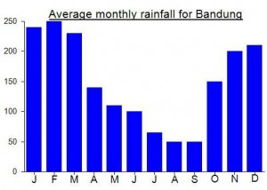
Local Average Monthly Rainfall (mm):
Location
Click on the blue arrow ![]() (top right) to see your current location on the map
(top right) to see your current location on the map
Origins and Meaning
Mount Holding-Up-The-World. Sangga means “to support something from below”, “to hold something up” and buana means “the world”. So sangga buana has something of the force of the English phrase “to take the world on your shoulders”. The significance of the name can be sensed if we compare it with the use of sangga buana in another context. In the front/north part of the Kasunanan palace in Surakarta there is a tower called the Panggung Sanggabuana. Just as Gunung Sanggabuana rises above the surrounding countryside, so also the Panggung Sanggabuana rises above the surrounding buildings of the Surakarta palace. It was the place where the kings of Surakarta meditated and met with the spirit queen of the southern ocean Kanjeng Ratu Kidul, so it had religious and meditative functions that may have been the same as those of Gunung Sanggabuana in former times. (George Quinn, 2011)
I last hiked Sangga Buana ten years ago to the month. I remember it being a very pleasant forest hike but I also remember the scorching heat, as back in 2010 I got the bus to Karawang to meet the guide and we probably didn’t get started on the hike until 10am or so. This time, we were moving by 6:30am and it made an important difference.
The road that was being repaired back in 2010 now stretches higher up the mountainside, at least from memory, and I couldn’t find the ticket booth at all! We just got hiking after leaving the motorbike in the village and presumed we would pay upon return. As it turned out, the entrance is at an elevation of over 500m above sea level, a good 20 minutes or so from the village. There is a very good map on a board here, and at at least 3 more points on the trail (the two trail junctions and the western summit).
It has only just re-opened and the trail was fairly busy with a mix of folk – religious pilgrims from the local area, hikers, and primary school students! At the camping area, after what must have been the fifth offer of coffee before 7.30am, we were directed to the western trail rather than just plodding on straight up the mountainside behind the camp buildings. This eastern one is apparently steeper, less used, more overgrown and so on. So we took the main route, the western one, which is across the stream on the right of the camp.
The forest is brilliant – the flat ridge at around 1000m elevation is just lovely. I could happily walk that kind of thing all day listening to birds and insects. At the bamboo shelter which is falling into serious disrepair, there is a trail leading down to the right – no idea where this leads but make sure you don’t take it by mistake. By the graves hut where the alternative narrower trail up from the camping area apparently meets the main trail we couldn’t spot the junction on the left at all, so later we came back down the same way.
Up at the first summit, the western summit, the kampung folk were as friendly as I remember from 10 years ago. I used the Bakosurtanal map heights for our first edition of the trail map, but my GPS supports the 1291m height for the western top so I will have to amend it when we get round to a second edition.
My co-hiker was confused when I pointed to the other peak and said I was going there too! But when we got there the GPS had a reading over 1300m so it really does seem to be the higher one. This eastern peak (or ‘Puncak 1’ as it is known) is much nicer now than back in 2010 when it was covered in rotting buildings and litter. It’s a great spot to have a rest, with at least two of the 3 cement pillars being perfect seats (the third is far too small!)
After politely declining another ten coffees on our descent, we then proceeded via Karawang towards the coast to see the ancient Hindu temples – Candia Batujaya (Candi Jiwa and Candi Blandongan) – that I only heard about this year. Absolutely brilliant. Sadly still closed but on a Sunday it was packed with locals wandering round the fences and having picnics there, perhaps combining it with the beach at Tanjung Pakis. A long way from Sangga Buana, admittedly, but worth a day out of Jakarta in its own right for sure. A lot of folk think Karawang is pretty dull – but both up in the mountains and out towards the coast there are some great places.
hi… do you have tracklogs for sanggabuana? tq
Hi there, you can get the gpx by link to
https://www.dropbox.com/s/wercgsoqg61le01/The%20Sanggabuana.gpx?dl=0
Great!