
Facts
- Elevation: 2,886 m (9,469 ft)
- Prominence: 2,868 m
- Ribu category:
 Tinggi Sedang
 - Province:
 Sulawesi Selatan (South Sulawesi)
 - Coordinates: -5.3536, 119.9347
- Rating:


 (13 votes) Add your rating
 Loading...
 - Other names: Also spelt ‘Lompobattang’
- World Ribus ID: 69013
Photos


Bagging It!
This Ribu is the second most prominent peak in Sulawesi (after Latimojong’s Rantemario). It was first climbed in 1840 by James Brooke, an Englishman who later became Raja of Sarawak. It must have been a major expedition to reach the summit ridge in those days but now it is a popular and frequently climbed mountain that could even theoretically be done as a long day hike.
The mountain range actually consists of two major mountains – Lompobatang (2,886m, also spelt with two ‘t’s) and the more northerly and slightly lower Bawakaraeng (2,840m). Because of the proximity of the mountains to the bustling city of Makassar both peaks are climbed by student hikers almost every weekend. Some of the really adventurous hikers actually climb both in one trip, although this requires a minimum of four days and usually five. According the local legends, Lompobatang has female characteristics and Bawakaraeng has male characteristics, the latter being more cruel than the former in terms of how many hikers have perished on its slopes.
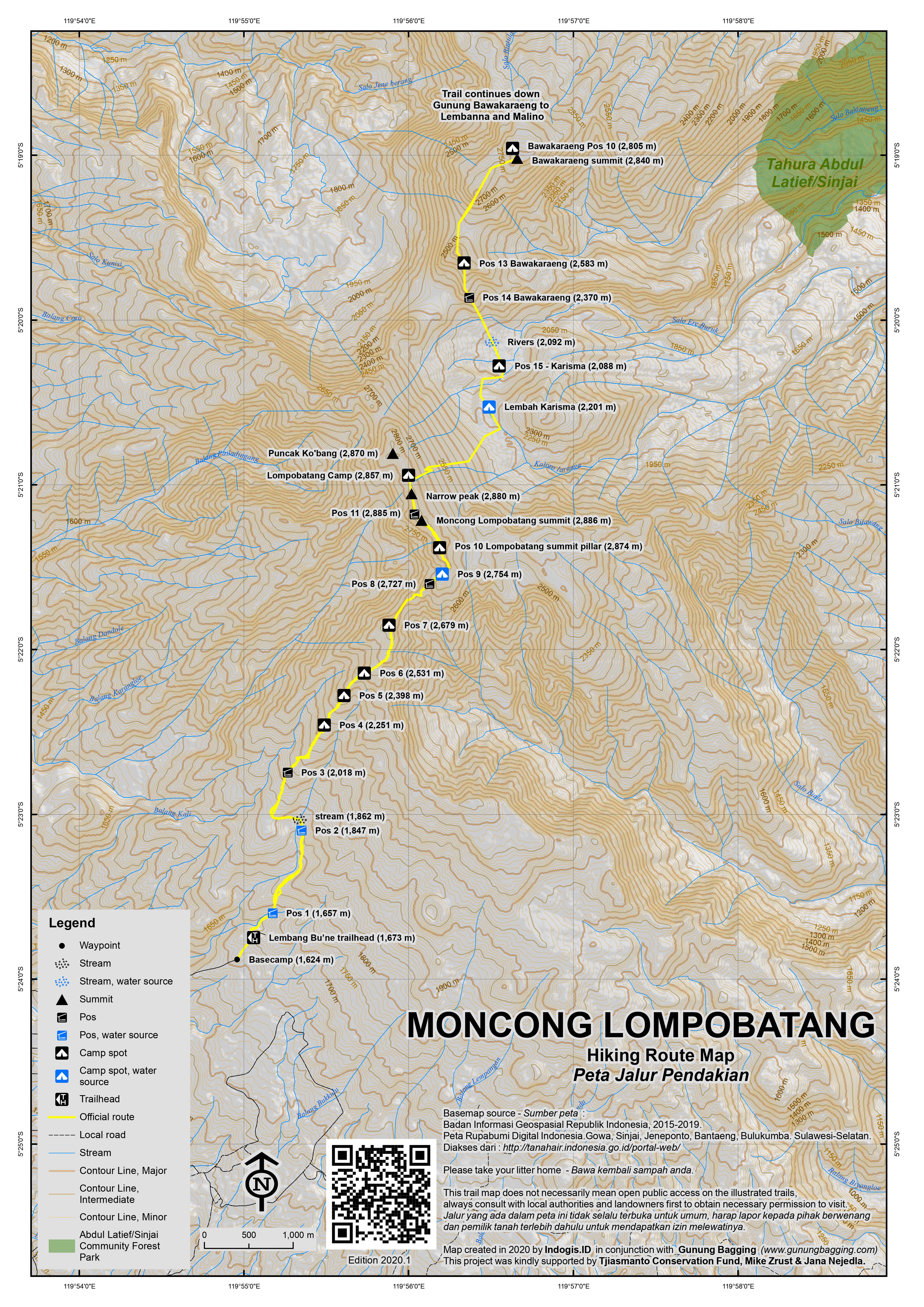
There are two main access routes to the range. The southern approach which is used for Lompobatang starts from Lembang Bu’ne village near Malakaji to the southwest of the mountain. The other approach is from Lembanna near the popular hill resort town of Malino which lies to the north of the mountain and is used by hikers wishing to climb Bawakaraeng. Since Malino is only 2 hours from Makassar it is considerably more popular than Lompobatang but both mountains are fabulous in their own right and if you have sufficient time a traverse of the range would provide a truly memorable experience.
The starting points for both mountains are relatively high up yet both treks are substantial and involve some occasionally tricky terrain. It is rare – though not impossible – for hikers to climb and descend either mountain in a single day. For example, Lompobatang would require 11 or 12 hours from reasonably strong hikers for a return trip. The following is a report for Lompobatang, the higher mountain of the two – and therefore the Ribu.
To reach Malakaji from Makassar, there are now two options. In the past, it was standard to follow the main road south to Jeneponto near the south coast. This requires around 4 hours. From Jeneponto take a left turn onto a narrower road which twists and turns for 40km up through villages to the south west of the mountain. Finally you will reach Malakaji, which is the last place to buy supplies of any note.
However, in 2020, a shorter (just over 100km) and slightly faster rural route which at first follows the Jeneberang river inland and via Bungaya, Bontolempangan and Rappolemba. This route is windy but requires a little less time at around 3 and a half hours.
This hilly area of South Sulawesi is well-known for passion fruit (markisa). From Lembang Bu’ne, turn up Jalan Lompobattang which turns into a stone track for a further 3 or 4 km before reaching the basecamp (1,624m) which is a simple wooden village house, with a newer building next to it. It is not well signposted so best ask locals working in the coffee plantations. Most ordinary cars can manage this last section no problem but it is rather bumpy and steep so many motorcycle passengers will have to get out and walk in a couple of places.
From the basecamp, where there is enough space leave motorbikes and a couple of cars, follow the stony track up the hill for a couple of hundred metres before following a small path down to the left (1,660m) behind a village house through onion fields. The path leads to a couple of stone walls separating farm fields and these can be ascended easily. There are some arrows pointing the way, so you shouldn’t have much difficulty finding the way during daylight hours.
Soon you will have reached a sign by a river, which is Pos 1 (1,657m). This is the most reliable source of water before Pos 9 so fill your bottles here if you need to. From Pos 1 it takes about 30 minutes along a rather overgrown trail to Pos 2 (1,847m) which is by a small mountain stream. After Pos 2, there is another small stream crossing (1862m) as the trail enters dense forest and the views become much more limited.
It takes about 30 minutes to reach Pos 3 (2,018m) and a further 30 minutes to Pos 4 (2,251m) which is a nice opening large enough for 2 or 3 tents. If climbing at night, this is the first point at which you will see the lights of towns and villages below. It can get very windy here though so be warned. The density of the trees lessens from this point on and allow views of distant ridges. Pos 5 (2,398) is the best place to camp within the forest, with enough space for 4 or 5 tents.
Beyond Pos 5 is an area inhabited by ‘babi hutan’ (wild pigs) and although you are likely to hear some if you camp here you will probably not see them. There are some good spots for views, notably at around 2,452m. Pos 6 (2,531m) is the last forest post and also makes an acceptable camp spot with some good views too.
The trail gets progressively more interesting and challenging from this point on. Pos 7 (2,679m) is a minor peak in its own right (Moncong Assumpolong according to Open Street Map) and is also a reasonable camp spot. In clear weather you should be able to see the fabulous narrow ridges ahead coated in low bushes and occasional Edelweiss. Many of the low growing trees are covered in a moss that is boiled by local people for the treatment of asthma.
Directly after Pos 7, the trail descends quite steeply before climbing again to Pos 8 (2,727m). This ‘land bridge’ section between Pos 7 and 8 is rather dangerous at times and requires you to use your hands, especially in inclement weather when the rocks could be slippery. The views in fine weather are stunning. Finally you will reach Pos 9 (2,754m) which is a huge boulder with some overhang offering some shelter. This is also the best camping area on this side of the mountain because, although there is only enough space for 4 or 5 tents, the views are tremendous and it is less than 30 minutes from here to the trig pillar otherwise known as Pos 10 (2,874m). There is also a reliable water source 200 metres downhill.
The section between Pos 9 and 10 is in places the most technical and dangerous. You need to be reasonably good at rock scrambling. The trail leads up to the right before the huge boulder and then onto a very narrow ridge. One section of the ridge is blocked with a rock formation that you must take extra care clambering over. In 2020, there is a simple rope to hold onto, but it is much more vital to hold onto the rocks themselves as you negotiate the tricky terrain. To make up for this, the views are stunning here in every direction.
Pos 10 (2,874 metres above sea level) is crowned with a triangulation pillar, a boulder with names written into it by previous hikers and a small antenna compound. It should have taken no more than 30 minutes from Pos 9, or about 5-6 hours from the basecamp (it’s around 4 hours back down). Almost all local hikers regard this spot as the summit of Lompobatang. This is the usual destination of most hikers who enjoy the view, take some photos by the pillar and hiking club signs and slowly begin the return journey to Lembang Bu’ne.
But in clear conditions you will see the ridge continue for over a kilometre northwards – via what is clearly higher ground. Indeed, the true summit of Lompobatang is in the general area known at the basecamp as ‘Pos 11’ but there are no signs on the route (in 2020). Fortunately, this ridge is fairly easy terrain and a real delight to walk along.
From the remains of the antenna compound, the path leads down a little before ascending again to a narrow ridge with some very picturesque boulders. From here, the view to Bawakaraeng is stunning in the early morning. The trail is quite easy to follows with few obstructions and great views in all directions.
The first top to be reached beyond Pos 10 has a boulder on it and based on GPS readings in 2020 is the highest peak at around 2,886m. It is less than 20 minutes from Pos 10 to this point. However, if you want to be sure you have bagged the highest point, it is almost essential to continue for a further 3 minutes or so to another grassy top which according to GPS is around 2,885m. Let’s call this Pos 11.
From here, the trail drops down, following the top of the ridge, including one point where you clamber round some rocks on the very crest of a narrow section of ridge. You will see a narrow, rocky-looking peak ahead. According to GPS, this is around 2,880m, so not as high as the boulder peak and the grassy peak. It takes no more than 30 minutes to reach this point from Pos 10, so allow one hour return, or longer if you want to explore even further.
Beyond the narrow peak, it appears that there is no more ground of a similar height, although the ridge trail continues beyond the junction for Lembah Karisma and the traverse to Bawakaraeng (down to the right) to Puncak Kohbang / Ko’bang which is the alleged site of the tomb of the King of Gowa. It is a place of pilgrimage for local people and indeed the whole mountain range is highly spiritually significant – there are numerous mystical stories and superstitious advice connected to the area.
According to the Bakosurtanal map, the area near Puncak Kohbang is actually 2,870m – just 4 metres below Pos 10 – and is a grand viewpoint down to the valley between Lompobatang and Bawakaraeng. It has been noted that a peak near Puncak Ko’bang is higher than Ko’bang itself and possibly even higher than Pos 10, though based on our 2020 trip as far as the narrow peak (2,880m) it seems most likely that either the boulder peak (2,886m) or the nearby grassy peak (2,885m) is the true summit of the range.
For hikers wishing to cross (lintas) the entire range, the trail heads down to the right before Puncak Ko’bang, leading down into Lembah Karisma (Charisma Valley, named after the Makassar hiking group that opened the route in 1987). At this point the terrain becomes very steep and difficult, taking about 7 hours to reach the valley (approximately 2,200m in elevation).
Most hiking groups spend one night in the valley where there is ample space to camp and also water sources. From this point, the Pos numbers descend from 15 back to Pos 1 near the trailhead for Bawakaraeng at Lembanna. After having spent a night in Charisma Valley, the following day hikers start the ascent up to the peak of Gunung Bawakaraeng – apparently this requires the best part of a day too. Reports from hiking clubs who have completed this trip say that there are rocks on this section of the expedition that contain metal that can render compasses useless. There is also a tricky rock section where only one person can pass through at a time. After a third night on the mountain range, in the large field near Bawakaraeng summit, they slowly descend to Lembanna and take public transport or ojeks back to Malino and then home to Makassar.
Bagging information provided by Daniel Quinn (updated October 2020)
Trail Map
For a high quality PDF version of this and other trail maps, please download from our Trail Maps page.
Practicalities
- Getting there: For Lompobatang, there are two options. The old route: follow the main road south of Makassar towards Talakar and on to Jeneponto where you take a left turn for the 40km to Malakaji. From Malakaji it is about 12 kilometres to the basecamp at Lembang Bu’ne (4 hours total from Makassar). The new route: inland via Bungaya, Bontolempangan and Rappolemba (3.5 hours total from Makassar).
- Guides and GPS Tracks: Want a PDF version for your phone? Looking for a guide? Need GPS tracks and waypoints? Moncong Lompobatang information pack can be downloaded here.
- Trip planning assistance: Would you like Gunung Bagging to personally help you in arranging your whole trip? Please contact us here.
- Permits: Register in the village at the basecamp (approximately Rp20,000 per person in 2020, including a coffee).
- Water sources: Available at Pos 1, 2 and near Pos 9. Water also available in Karisma Valley.
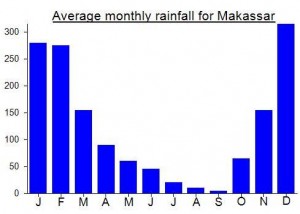
Local Average Monthly Rainfall (mm):
Location
Click on the blue arrow ![]() (top right) to see your current location on the map
(top right) to see your current location on the map
Origins and Meaning
‘Moncong Lompobatang’ means ‘Big Belly Mountain’ in Makassarese (Anthony Jukes, 2011)
Had a very successful trip to Lompobatang last weekend. Was quite worried due to the seemingly never-ending covid chaos that I would actually be able to get there and get back in a weekend, but I just about managed it. The key is to use Flightradar24 app to check which flights are cancelled the 7 days prior to your flight. And if it’s cancelled every day then chances are it will be cancelled on your day too, and the airline just hasn’t bothered to tell you and will let you know just a few hours before, making it near impossible to get to the airport in time for your rescheduled and probably much earlier flight.
I’m talking about Lion Air, of course, who have a website that looks like it was made by a primary school student, but actually fly to many places that other airlines don’t. So, sometimes you don’t have an alternative option!
Anyway, I booked a 4am flight originally with them, to allow enough time to be sure to actually get to Makassar and on to the mountain the same day. This was soon changed to a 2am departure. Not long after, I got another SMS…. It would be 3am. And then the evening before they changed their minds once again and presumably moved everybody onto the 8am flight. No problem actually, as I could have a good night’s sleep the night before. But deeply confusing for anyone trying to plan anything based on arrival times.
By the time I got to the airport I had already seen that my return flight with Lion, originally 9pm, then moved to 8pm, then moved to 7pm had been cancelled every single day for at least the previous 7 days so I cancelled Lion’s return journey and booked Sriwijaya for the return leg (a flight at 1855 that had flown every single day the previous week). This was a good move as Lion would presumably have sent me an SMS around midnight whilst I was trekking to let me know I had been moved to the 1630 flight I had only a slim chance of being able to get. Why they can’t just show a bit of respect and good manners and let folk know a minimum of 48 hours in advance when they know it is 99% likely to be cancelled…. It’s one of those eternal Indonesian questions. Why not show a bit of respect for your customers instead of distrupting their plans at the last minute with no good cause? Why sell tickets for 6 different flights for a route each day when you know only 2 of them are going to fly?
Anyway, made it to Makassar fine, and set off to the mountain with 3 guys from the YPUP hiking club. The new route to Lompobatang is very windy indeed – ok on a motorbike (though you will be sore afterwards) but in a car I imagine you would feel pretty sick. There are some very scenic parts of this route, and other bits that are like a building site.
Lovely late afternoon weather – but very, very windy, with gusts blowing the basecamp / village house sufficiently strongly to have to keep everything indoors for fear of it blowing away. A young man at the basecamp said he thought the true summit was Pos 11, so that was promising to hear. I didn’t mention Puncak Ko’bang because last time I asked a local hiker about that, thinking it was the true peak, he became very suspicious of why a foreigner would want to visit what is thought to be the resting place of a King of Gowa. Best not mention it. Pos 11 sounded good anyway.
We set off after dark, with torches, with the plan being a few hours of rest at Pos 9, but no tent to have to carry to slow us down too much. It worked out quite well. Because the trail starts at over 1,600m, it is a delightful temperature and the gradient is not too steep to begin with either.
There were a few other groups camping at various Pos, but nothing on the scale of Java where you have hundreds making noise and litter every weekend. Indeed, there was almost no litter on the trail at all, so well done to the local hikers here.
Beyond Pos 7, the wind was like a gale, but not a constant blast, a series of unpredictable gusts, which made the Pos 7 to Pos 9 part pretty challenging. You would not want to be blown over next to a steep drop, of which there are many on this section.
At Pos 9, there were 3 tents already set up. We just used a couple of flysheets, sleeping bags (those sensible enough to have brought them) and put on all our clothes, but it was colder than expected, perhaps due to the windy conditions. Why so windy? Probably because October is changing of the seasons time, making this weather more common.
In the middle of the night, it was quite beautiful outside, with the lights of the villages and towns in the distance, and clouds being blown rapidly over Pos 10 above where we were. Constellations clearly visible and a couple of shooting stars. I wondered if James Brooke had really made it this far. I very much doubt he got to Pos 11 to bag the highest part of the ridge, but what did he regard as the summit back in 1840? Pos 7? Pos 9? Pos 10?
We were up on the Pos 10 ridge before sunrise, and I had completely forgotten about how challenging the rocky chimney section was. In gusty conditions it was even tougher, but we made it and what a view from Pos 10. After my last visit where there was no view at all, and the guide had been ‘sure’ this was the highest peak, it was great to see he was wrong and to actually look at the higher ground in question. Funny how the SRTM data for Pos 10 is so bad (showing this spot as less than 2,800m) – must be because it is a narrow ridge, completely missed by the satellite. But to think people are using Google Maps terrain data thinking it is of a high quality – there are so many cases where it is way, way off the mark and should not be used as a reliable data source if you have a GPS reading or a reasonable topographic map to use instead.
We set off from Pos 10, along what is pretty easy-going terrain with superb views in all directions, and in no time were at the first possible true summit of the range. There are basically 4 possible peaks that at least 3 of which are higher than Pos 10:
Boulder peak (2886m on my GPS) – a lovely spot with a boulder over 1m high at the top. Based on GPS readings, the highest.
Grassy peak (2885m on my GPS) – just 3 minutes beyond the Boulder peak. Very similar height.
Narrow peak (2880m on my GPS) – about another 10 minutes from the Grassy peak, looks impressive but is not as high as the previous two.
Puncak Ko’bang (2870m according to Bakosurtanal) – not visited in 2020 as the others were waiting for me back at the Boulder peak and we had to get back to Makassar for my flight to Jakarta, and more crucially because from the Narrow peak it looked pretty unlikely that there was any ground higher further along near Ko’bang. Not the highest.
Peak just beyond Ko’bang (unknown but higher than Ko’bang and probably higher than Pos 10 according to John Hargreaves – see comment below) – again not visited in 2020 but based on sight did not appear to be higher than Boulder or Grassy and probably not Narrow peak either.
If you wanted to get to the peak beyond Ko’bang and back from Pos 10 I would allow 1.5 to 2 hours to include photo time and GPS checking time. From sight, there did not appear to be ground higher than the Boulder peak and Grassy peak beyond the Narrow peak, but I could be wrong. Based on GPS the Boulder peak is the highest, but given how GPS readings fluctuate, it could well be that the Grassy peak is actually a few centimetres higher. The Narrow peak looks impressive but appears not to be as high as either Boulder or Grassy based on GPS and sight. As for the 4th peak, the one beyond Ko’bang, as I didn’t visit it I cannot give a GPS reading but would guess similar to Narrow peak. But I could be wrong and the peak beyond Ko’bang could also turn out to be the highest. But for now, I am fairly confident that I bagged the true summit by visiting bother Boulder and Grassy. That will do unless new evidence comes to light! A proper survey would be great – and to include Bawakaraeng too, as the current Bakosurtanal 1:50,000 is not up to the job.
For public transport users traveling to Lompobatang, there are shared Kijangs direct to Malakaji from the Sungguminasa Terminal, southeast of Makassar. They take 4 hours, cost Rp40,000 and mostly leave early in the morning, though a few depart later in the day. From Malakaji, we took ojeks up to the main part of Lembang Bu’ne to seek accommodation in a village house. The hospitality here was excellent, but the process of finding a guide was protracted. A better choice would be to head straight up to Parambintolo, where there are about 25 houses, including that of our eventual guide Pak Ramli (hp: 085298781961).
At 9 am next morning we began hiking, reaching the triangulation pillar at pos 10 after 6 hours. We pitched camp beside the dilapidated antenna, where there is a grassy patch big enough for 2 or 3 tents. This site is more exposed than Pos 9, but the corrugated metal remains of the adjacent battery housing could provide some shelter in bad weather.
In the 2 hours before sunset, we made an exploratory hike along the ridge to Puncak Ko’bang and back. The slabs assembled there make an atmospheric gravesite, and the large grassy area would be another good though exposed campsite.
GPS altitude at both Pos 10 and at Puncak Ko’bang fluctuated between 2870m and 2885m. However, we passed 3 intermediate tops en route to Puncak Ko’bang, and a further top beyond it, giving GPS altitudes between 2877m and 2904m. Visually, these 4 peaks all appear higher than either the triangulation pillar or Puncak Ko’bang, so one of them may well be the true highpoint of the range. A new, definitive survey is needed!
We had clear night skies with the lights of Makassar clearly visible in the distance and views next morning both southwest to the coast and north toward Bawakaraeng’s spectacular ridge. (Bawakaraeng also appears visually to be closer in height to Lompobatang than the official 44 m differential suggests.) The ridge between the antenna and Puncak Ko’bang is a lovely place to be and with several species of very approachable birds as well.
On this long holiday weekend we met about a dozen hiking parties up and down the mountain, both locals from Malakaji and student groups from Makassar.
Descent to Parambintolo from Pos 10 took 5 hours, including a long cooking and bathing stop at Pos 2. After several cups of the delicious local Arabica coffee, we found an afternoon Kijang for the 4 hour journey back to Makassar.
Mr. Dan, may i have your GPS tracks/waypoints during your travel from Makassar to Malakaji village?
There are no roads to reach that village in my GPS’s map, so it would be very helpfull if i had your GPS tracks/waypoints from Makassar to Malakaji village.
Thanks Mr. Dan
Yess.. check out my google+ i’ll upload it soon
Finally after 4 rough days, we succeed to traverse the Kharisma valley from Bawakaraeng to Lompobattang… Such a wild, wild jungle, huge valley, and adventurous trek. We enjoyed the obstacles with all the difficulties and pains.. Daniel, could i make the report for Bawakaraeng? We discovered (when we stayed in basecamp in Parang Bintolo village) that mostly people start the traverse from Lompobattang instead of Bawakaraeng like we did. Difficulty level, both mountains are the same, the steep, trek and duration (6 hours from Bwkaraeng to Kharisma and 6hours from kharisma to Lompobattang)
A must try double summits of Sulawesi
Well done Gita. And you are welcome to do a write-up for Bawakaraeng. Do you have any photos?
Is it possible to hike G Lompobattang starting from Malino?
Tidak bisa,,, rute Lompobattang hanya bisa ditempuh dalam 3 rute
1. Na’na, Desa Kindang Kab. Bulukumba
2. Bontolojong, Kab Bantaeng
3. Lembang Bu’ne, Kab. Gowa
are there any photos?
could you please send it in my email ???
you can also go up there through Bantaeng but take a little longer
with views that are not less good with the other pathways
This beast has been on my list for quite some time and I finally climbed it last weekend. Not having enough time for a traverse of Lompobatang and Bawakaraeng (you need 4 days) I obviously decided to go for the higher of the two, Lompobatang. Heinz and Roman did this just a few months ago so I had their trip report to help me prepare. In addition, I got in touch with a fabulous man called Dodo who lives in Makassar and is a legend to many foreigners who have passed through the city. I urge you to get in touch with him if you visit Makassar and are in need of help to arrange things – you couldn’t find a more generous, amusing and energetic man! His blog is Dodopenman.blogspot.com
He picked me up at the airport and we headed off for a local ginger drink – Sarabba. Dodo put me in touch with a group of student hikers ( see http://www.mahesa.or.id ) who had been up Lompobatang a couple of times. A great bunch – one of them, Dede, had recently cycled all the way from Makassar to Manado (it took 1 month)!
The following morning we set off on the 4 hour journey to Lembang Bu’ne. I originally suggested that we could just climb at night in time for dawn at the summit and then back down again the next morning, therefore removing the need for tents etc. However, the boys obviously wanted some quality time lounging around in the forest eating endless indomies (instant noodles). So after leaving behind some basic gifts and praying for a safe trip we left the basecamp (basically the house of the village head) at around 7pm on the Saturday evening.
By Pos 3 a couple of the hikers were having real trouble and it was decided that we would camp at Pos 5 and set off to the summit at 3am. The night brought moderate winds and light rain so nobody except me wanted to leave the camp until first light. In fact, only 3 of us did. It was still grey at 6am and I think the others wondered why I even wanted to bother given that the view would be very much limited. Indeed, my photos do not do justice to this mountain at all. In fine weather it must be one of the top mountains in Sulawesi. Despite the weather, the terrain beyond Pos 7 was an absolute joy to negotiate – narrow ridges, occasional Edelweiss bushes, steep rocky terrain, lonely slabs of rock seemingly randomly positioned by the side of the trail. There were a few nice moments when the clouds parted to allow a glimpse of the ridge we were on – but overall we were rather unlucky. By Pos 9, the chaps decided it was time for more noodles and coffee and we sheltered under the huge rock cliff. I waited…and waited…. finally Dede (he who cycled all the way to Manado earlier this year) said he would come with me whilst Rio stayed behind for some more rest. The last section was even more fun (and also more dangerous) than any other part of the trail and you really have to be happy doing a bit of minor scrambling for one section over a narrow ridge of rock.
My GPS said we had over 1km still to go before the highest point but suddenly the cement trig pillar appeared before us, along with a rock on which are carved the names of many hikers who have celebrated reaching this peak. I couldn’t see ‘James Brooke’. There’s also a sign in the trees proclaiming this peak to be Pos X (10) – the true top. My GPS gave 2878m which is about right for a mountain with an official published elevation of 2874m. I had a quick look at the nearby rusty transmitter compound and checked that the trail really did only go down. It was too grey to see very far but this was definitely a major top. Only thing was, my GPS was telling me the real peak was over 1km away towards Bawakaraeng. Very odd. I asked Dede and he said the trail just leads down towards the valley (Lembah Karisma) between Lompobatang and Bawakaraeng and that the trig pillar is the true summit. This ties in with all of the pictures I have seen online of other hikers and there is no mention of a peak higher than the one with the summit pillar.
SRTM /and Google Earth errors are not uncommon, especially in steep terrain e.g narrow ridges. Having gotten a GPS elevation reading of above the published height I reluctantly decided not to completely test the patience of the now rather wet students by insisting we continue even further beyond what any normal person would call the ‘summit’. So me and Dede returned to Pos 9 and found Rio half asleep in the semi-cave beneath the huge rock. We then had a rather uneventful trip back down to Pos 5 and then back down to the village and home. Dodo was, of course, waiting for us with some food and magic tricks!
The following day me , Dodo and Iren (a dental student from Toraja) went to a Muslim children’s party and listened to some dangdut music. Dodo sang a song about a sakit hati (heart ache) being better than sakit gigi (toothache). Later I enjoyed a ride in one of those mad motorized becaks (‘bentor’). It was a hilarious experience but I couldn’t stop thinking about whether or not I had bagged the true peak! Strangely, one of the computers at Makssar airport had Google Earth installed on it so I had a quick check. SRTM data (including elevation data on Google Earth) is generally always a bit wrong (generally 15 m minimum lower than the true height of a mountain, but this can increase in areas of steep terrain). The trig pillar summit I had visited was 2878m on GPS yet about 100 metres below that on Google Earth. The highpoint on Google Earth (1km further to the NW) has an elevation of about 2840m.
This obviously called for a second, definitive opintion – the topographical map of the area from Bakosurtanal. The following day I managed to get hold of sheet 2010-62 (Malakaji) Scale 1: 50000. The trig pillar summit is 2874m. The NW peak (un-named on the Bako map but known to local hikers as Puncak Ko’bang / Kohbang) is 4 metres lower at 2870m! So we had reached the highpoint and Google Earth data is wrong (mainly because of the steepness and narrowness of the summit peak). I’m sure a trip to the NW peak is worthwhile in good weather though, because from there you would be able to see the valley separating Lompobatang from Bawakaraeng.
Ultimately, the poor weather on Lompobatang has given me an extra incentive to head back to the area and climb Bawakaraeng next year sometime. Better luck for other hikers for this mountain range is truly excellent.
I had been planning to make a traverse of Lompobatang and Bawakaraeng this coming (long) weekend. Despite being less than 4km apart, it turns out that one day is not enough to get from the summit of Lompobatang to the summit of Bawakaraeng, such is the steepness and difficulty of the terrain. So it’s a 4 day trip to do Malakaji-Lompobatang-Bawakaraeng-Malino, more time than I have so I’ll have to save the slightly lower Bawakaraeng for another time. Interestingly, the traverse route (lintas Lompobatang-Bawakaraeng) was pioneered in 1987 by by an Indonesian hiking club called Karisma. The valley between the two peaks is know know as Lembah Karisma (Charisma Valley) and there are two small rivers there.
I hope to write a full report on my return from Lompobatang next week…
A fantastic and detailed write-up by Heinz von Holzen is here….
http://indovolcano.com/mount-moncong-lompobatang-sulawesi.php
Does anyone know if there are any species of Duck native to the area?
Ada sesiapa yang tau kalau ada spesies Itik/Bebek yang asli di tempat Moncong Lompobatang?
According to a friend, there’s an endemic flycatcher there, not sure about ducks. Try the site http://burung-nusantara.org which has listings for local guides and sites “around makassar”.