
Facts
- Elevation: 2,372 m (7,782 ft)
- Prominence: 641 m
- Peak category:
 Spesial
 - Province:
 Jawa Timur (East Java)
 - Coordinates: -7.7676, 112.4790
- Rating:


 (5 votes) Add your rating
 Loading...
 - Other names: None, but there are numerous names for different peaks on the range. Anjasmoro is the name of both the range itself and also one of the tops.
Photos


Bagging It!
UPDATE (June 2022): Based on recent news stories it appears that all of Anjasmoro is officially off limits to hikers except the short hike up Watu Jengger. A sad state of affairs. The mentality now seems to be that unless there is an official trail then it is illegal to go hiking. The information below is kept purely for reference purposes and we cannot encourage anyone to go hiking on Anjasmoro now as it is illegal according to the authorities.
Overview
Occasionally people email to ask about the huge massif known as Anjasmoro to the west of Arjuno-Welirang. This is a vast and – for Java – wild range, with a name of Sanskrit origins. Alfred Russel Wallace visited Wonosalam but described the area as being on the slopes of Mount Arjuno and indeed they together form Taman Hutan Raya Raden Soerjo (Raden Soerjo Forest Park). According to the Jombang City Guide website, “when interpreted per word, anjas means a stronghold or fortress, while asmara means love. When combined, Anjasmara means the stronghold of love or the stronghold of joy and sorrow.”
Inextricably linked with the Majapahit era, the Trowulan archaeological site near Mojokerto features Hindu temples and ancient graves, including – in the Sentonorejo Tomb Complex – the grave of Goddess Anjasmoro herself, Raden Ayu Anjasmoro next to Ratu Ayu Kencana Wungu (the Majapahit Queen).
At the time of writing, in 2019, unless you are on the Carangwulung (Wonosalam) or Rejosari routes at the northern side you are unlikely to meet any other hiking groups at all, even on weekends! Pleasingly, there are still hornbills living in this area.
In brief, the Carangwulung, Wonosalam trail to Puncak Cemorosewu is excellent for views of the remarkable Gunung Bokolorobubuh and can be accomplished in half a day. The Rejosari, Jatirejo trail to Puncak Semar and Puncak Bayangan is excellent for getting quite close to the remarkable Gunung Boklorobubuh and gaining an understanding of the range as a whole. It can be accomplished in one long day but it is better to camp one night at Puncak Semar. Finally, the Cangar route to Anjasmoro top and Gunung Biru is the best trail on the highest ridges of the whole range and can also be accomplished as a dayhike by the fit and experienced.
Anjasmoro has no craters but there are hot springs to be found on its slopes including at Pacet to the north-east and at Cangar to the east at the col with Arjuno-Welirang. One of its major tops and by far its most unique-looking, Boklorobubuh, is often remarked upon by hikers on nearby mountains staring over at this unusual summit. Indeed, it can be seen clearly from Gunung Butak, Penanggungan and Arjuno-Welirang and has a very different profile depending on the angle from which you see it.
There are three main trailheads on very different sides of the range – Wonosalam on the north-western side, Rejosari on the northern side, and Cangar on the eastern side – but a traverse from one to another is either not possible at all due to steepness of terrain and lack of connecting trails, or because it would require a week or more to complete as part of a serious expedition across numerous different ridges.
In addition to the three main trails that are known to hiking communities, there are numerous other minor trails scattered across the range, most of which see very few hikers, or are just typically used by farmers or hunters occasionally, and many of these routes are heavily overgrown and therefore incredibly time-consuming to use. Across the vast mountainous area, there are also many sections of very steep terrain and some cliffs that are really only for expert rock climbers.
As you will see below, exploring the whole mountain range requires at least 4 or 5 different outings. To try to minimise confusion over all the different peaks, the following are the six principal mountains in the Anjasmoro range, in order of height (all heights from the usually reliable Bakosurtanal maps), which are dealt with below in reverse order.
Gunung 1 – Unnamed peak – 2,372m
Gunung 2 – Gunung Biru – 2,331m
Gunung 3 – Anjasmoro Top – 2,269m
Gunung 4 – Gunung Boklorobubuh – 2,230m
Gunung 5 – Gunung Argowayang – 2,197m
Gunung 6 – Gunung Gede (Puncak Cemorosewu) – 1,866m
FROM THE NORTH-WEST: Carangwulung, Wononsalam, Jombang trail to Puncak Cemorosewu (Gunung Gede, 1,866m).
The most popular trail in the Anjasmoro range starts from the village of Segunung (755m), Carangwulung, Wonosalam near Jombang to the north-west. This is one of the most famous durian areas in East Java. The trail goes nowhere near the highest peaks in the range but is an exceptionally pleasant hike with fabulous views from the top in good weather. If you only want to do one hike in the range and aren’t too bothered about reaching the highest peak then this one is definitely recommended.
Cak Kancil (+6282337535342) is the usual guide for this hike, and he is very friendly, fit and knowledgeable and so comes totally recommended. He also lives in the village and will typically be waiting for you when you arrive.
From Pos Singgah (755m, registration post and starting point next to Masjid Jabal Nur), the route follows a stone track on the opposite side of the road as it leads up through coffee and cassava plantations and past a couple of barns. There are some nice views down to the surrounding East Javan countryside. A minor ridge (960m) is gained after around 30 minutes, and if you have taken a local guide then he might offer you a delicious guava (jambu) fruit or two from one of the small trees here.
Pos 1 (Pos Kancil) soon follows (1,011m) and then the trail get steeper at a section known as Tanjakan Mbok Mbok. The trail enters proper forest at around 1,150m above sea level and not long after you will be at Pos 2 (Pos Salwa / Lumpang, 1,220m). It should have taken you around 60-90 minutes in total to reach this point.
The trekking beyond here is really pleasant – a combination of reasonable gradient, nice temperature and some superb views westwards. At an elevation of around 1,375m, you should in clear conditions such as most early mornings be able to see the Gunung Liman / Limas / Wilis massif to the west and further beyond to Gunung Lawu on the border of Central Java.
Pos 3 (Pos Bambu / Pring Rusak, 1,438m) is around 30 minutes beyond Pos 2 and in the rainy season you may meet leeches on this section. This is the last point for water, with a sign pointing the way down to the source on the left of the trail. Beyond Pos 3 you should hopefully be able to see the rocky pyramid peak of Gunung Kelud / Kelut on the right side of the trail.
The trail continues up before flattening out somewhat at an area known as Hutan Panjang (sign at 1,620m). A small spot for camping follows at 1,728m just before Puncak Bayangan (1,733m) where you could easily fit 4 tents. In total it should have taken you around 3 hours to reach this point. And it is here that you first get some incredible views of the other peaks in the Anjasmoro range.
Down to the left (eastwards) you should be able to see some very unusual, steep, dramatic peaks just a few kilometres away. This is Gunung Boklorobubuh, the most iconic of all the peaks in the Anjasmoro range and also one of the toughest to reach the summit of (see below for details). It’s probably more impressive when seen from another nearby peak as compared to standing on top of it, and various different peaks in the range provide a very different perspective (and therefore considerably different shape and outline) from each other.
There are other great views too. Behind and just to the right of the huge blocky chunk of Boklorobubuh is the much higher Arjuno-Welirang range. Welirang is likely to have a substantial plume of smoke trailing off into the sky above. Across the other side of the valley down to the south of Puncak Bayangan is the high ridge of Gunung Argowayang. There are no reports of anyone having reached the top of this, as you will read below, although it is likely to be yet another superb viewpoint. Between Arjuno-Welirang and Argowayang are a cluster of forest-clad peaks and ridges and these are actually the highest ones in the Anjasmoro range (Gunung Biru, Anjasmoro Top, and the un-named highest peak at 2,372m).
From Puncak Bayangan, it’s just another 20 minutes to the highest point and final trail destination known as Puncak Cemorosewu where the views to Boklorobubuh are even better. First you need to drop down a little way to the west (left) before the trail ascends again. Just before the summit, ask your guide to point out a few small pieces of rusted metal which are the remnants from a plane crash here in 1964.
The highest point here is marked with a narrow cement post. The peak is so named because of the many pine trees (‘cemara‘ / ‘cemoro‘) on the higher slopes. ‘Sewu’ means ‘thousand‘ or simply ‘many‘. Gunung Cemorosewu is also known on topographic maps as Gunung Gede (Gunung 6) which simply means large mountain.
However, ignore the signs at the summit suggesting this peak is 2,282m high (a figure presumably meant for Anjasmoro peak/top, the third-highest in the range which is near Cangar) – it is actually about 400 metres lower than that. After a quick rest and photos, it is definitely worthwhile going beyond the peak, dropping down a couple of minutes to a rock with a layer formation unsurprinsingly called Watu Lapis. Down a little way further is a grassy opening where no trees obstruct the view of the steep western cliffs of Boklorobubuh. This is the best photo spot and – as is typical in Java – you ideally want to be here by 9am or earlier for optimum conditions.
South of the peak, after a considerable drop, the ridge continues over several other peaks reaching Argowayang (2,197m) after several kilometres, which is the highest peak on the western side of the mountain range (see below for further information). To the south-west of Cemorosewu are a few lesser peaks including Gunung Watujombalan (1,616m) and Puncak Alang Alang (over 1,700m), named after the cogon grass which grows there. These subsidiary peaks are sometimes hiked from the west at Desa Jarak.
Many local hikers camp at the summit of Cemorosewu, and in doing so have a great chance of really impressive views at sunrise or sunset. However, given that if you are not lugging tents up the mountainside you could be up in around 3 hours and back down in 2, it is quite possible to do this as a dayhike or half a day, but best set out as early as you can if you are hoping for clear views at the top.
FROM THE WEST AND SOUTH-WEST: Galengdowo, Wonosalam Selatan trek to Puncak Tapak Bunder (1,482m) and Ngebrong, Pujon trek to Gunung Argowayang (2,197m)
The highest labelled peak on the Bakosurtanal map (1:25000 Pujon 1508-324) on the western half of the Anjasmoro mountain range is actually Argowayang (2,197m) (Gunung 5) which appears about 5km to the south of Gunung Gede / Cemorosewu and is best accessed from the southern side near Ngebrong (1,235m), Tawangsari, Pujon.
Less than half a kilometre before the village of Ngebrong, a farm trail leads off to the right through chili and cabbage fields. Before long, this meets the top of a minor ridge (1,346m) which can be followed, ultimately, all the way to the top of Gunung Argowayang. The trail is very, very rarely used by hikers but frequently used by local villagers collecting wood and so on from the forest and in December 2019 was clear enough for the majority of the route.
At around 1,534m, the trail enters scrubby forest before veering left and then steeply up the side of Argowayang. The path is more difficult to follow from this point with denser vegetation, but there are no junctions so simply following the ridge will lead you in the right direction. Look out for eagles and other bird life plus monkeys thrashing through the branches.
After a couple of false tops including a Pos (2,119m) where you could fit one small tent, the unmarked and overgrown top of Argowayang (2,197m) is reached. It will have taken most hikers around 4 hours to reach this point from the village road. The views to Boklorobubuh are likely to be magnificent but unfortunately on our visit we had low cloud obscuring the panorama. A small triangular-shaped stone sits near the highest spot.
Were there no steep cliffs further north, it might be possible to continue all the way to Cemorosewu above Carangwulung as part of a multi-day expedition, but the cluster of peaks inbetween (Gunung Gede – a different peak with Gede as the name! – and Gunung Gapit) have very steep sections probably making such an attempt completely impossible.
Returning to Ngebrong takes around 3 hours and it is possible to cut down through the plantations fields to meet a track leading directly to the village itself which may be of use if you have left your motorbike or car there. Note the incredibly impressive village mosque, which is architecturally quite beautiful and constructed of stone and glass.
There is another trail on this western side of the range which is recommended to those wishing to truly explore the area. The village of Galengdowo (650m), Wonosalam Selatan, is known in the local area as a place to go camping, visit waterfalls during the rainy season, and enjoy the local coffee. In 2019, it was also possible to hike to a minor side peak of the range called Tapak Bunder (1,482m). Much like the minor peaks on the northern side of the range, it is a superb viewpoint in clear conditions.
The road beyond Galendowo actually leads up to above 800m where an unmarked trail heads off to the left. Motorbikes can even be taken up the track a kilometre or so to around 860m where there is a small solar-powered flood monitoring device. Another turn is needed at an unmarked junction (890m), leading to the right, steeply up the hillside.
After a tough 30-45 minutes, a minor ridge is reached at around 1,108m. The trail flattens out here for a while, but may be overgrown if nobody has been here recently so a local guide is essential. A minor and easily missed junction (1,225m) down to the left goes to Desa Jarak but to continue up stay to the right. Certain parts of the ridge are covered in spiny vegetation that needs circumnavigating whereas other sections are really pleasant woodland (such as at 1,274m).
Another steep section up over a fern (‘pakis’) covered area follows before the summit is reached. Most hikers can be up here in under 3 hours, or under 4 if you have walked all the way from Galengdowo village. The name is not given on the Bakosurtanal map and their figure of 1,476m seems perhaps a little under the truth.
The view is surprisingly excellent. To the north-east is Puncak Cemorosewu. To the east are Gunung Gapit (1,990m – labelled Gunung Pegat on some maps) and Gunung Gede (2,129m) which together form the middle section of the lengthy western ridge that runs north-south from Cemorosewu all the way via Gapit and Gede to Argowayang.
Like much of the range, there are precipitous drops here and even reaching the main western ridge from the outlying top of Tapak Bunder seems impossible due to the steepness of Gunung Gentonggowok / Gentong Growah (1,993m) and lack of trail between Tapak Bunder and Gentonggowok. Therefore reaching Argowayang peak from here is probably out of the question.
But the finest peak that can be seen from here is of course the iconic Boklorobubuh, which peeks over the tops of the western ridge between Cemorosewu and Gunung Gapit. As usual, early morning is your best chance of this excellent view.
Tapak Bunder itself is an interesting spot, with a stone just below the highest point which seems to be used by local people for kejawen (traditional Javanese) rituals, complete with offerings including coins and eggs.
You can be back down at the road in just over 2 hours. For more information on Tapak Bunder and on Galengdowo in general, please contact the very knowledgeable Pak Endon 08525 9005057.
According to some online sources, Gunung Argowayang was originally called Margowayang, but other local sources suggest they are two different peaks and that Margowayang is much closer to the villages and well under 2,000m in elevation (perhaps what is labelled Gunung Jembek on some maps).
To get a proper understanding of this whole range would probably take weeks, and it is certain that this portion of the Anjasmoro range is a very mystical one, with historical stories of the sunrise creating moving shadows like a Javanese puppet performance, mysterious gamelan melodies drifting across the forested tops, and even tales of human bones being found in this remote and rarely-visited forest area.
Various trails FROM THE NORTH including from Rejosari and Nawangan towards Gunung Kukusan (2,013m), Gunung Boklorobubuh (2,230m) and Watu Jengger (1,096m).
The iconic and impossibly steep-looking chunky peak seen to the east of Gunung Gede is Gunung Boklorobubuh (2,230m) (Gunung 4). It is very noticeable from the slopes of the much higher Gunung Butak to the south, poking out over the top of the lower tops surrounding it. The geological story behind it must be fascinating, as it appears almost contorted beyond belief and ‘changes shape’ radically depending on your position in relation to it!
It’s connected by a steep, narrow and supposedly impassable ridge to the slightly more accessible Gunung Kukusan (2,013m). Boklorobubuh is the highest peak in the northern half of the Anjasmoro mountain range but only a very small number of adventurous local hikers have made it to the very top (most recently in 2020), typically requiring 3 nights camping to achieve such a feat in this remote location.
A lot of local people have never heard of Boklorobubuh and actually call it Kukusan. This confusion may go back a long time and have a complex history, so we are sticking with the names as given on the official Bakosurtanal map. Gunung Kukusan (Mount Steamer) is so named because in Java steamers are usually pointed like a cone and this sharp peak is a similar shape when seen from certain angles.
Alas, this name seems to be referring more to the shape of Boklorobubuh from certain angles as Kukusan itself is less steep and far less iconic when seen alongside its nearly 200m higher neighbour – but it is still quite steep and pointy nonetheless from some angles and all of the peaks in this area are comprised of generally very narrow ridges.
The lower and more accessible northern slopes of this cluster of peaks are not too far from the cities of Surabaya, Mojokerto and Jombang, and so it is no surprise that there are numerous tourist attractions in the foothills including minor mountain viewpoints. If you look at the map you will see several ridges and valleys running roughly south-north to the northern plains. A number of these ridges could be used as potential access routes for those wishing to explore the area to the north of Boklorobubuh as far as Gunung Kukusan.
Unlike the densely-forested southern and western parts of the Anjasmoro massif, many of the lower parts of these northern ridges are deforested, with long waist-high grass covering them. This means very, very slow going except in rare places where a clear and regularly-used trail has been made and maintained, such as the trail from Rejosari, but on the plus side offers panoramic views in all directions. It also means direct sunlight and little shade, so hats and suncream and extra water are all essentials.
Another more informal name for Boklorobubuh is Puncak Piramid (pyramid peak), which is how Boklorobubuh (or ‘Kukusan’ as some mistaken locals call it) appears from some angles – including from Goa Sigolo-golo (Sigolo-golo Cave), Air Terjun Sekelip (Sekelip Waterfall) in Wonosalam and on the road out to the starting point for the trek to Puncak Cemorosewu from Carangwulung.
Further east near Mojokerto, the peak has a very different appearance from below. Less the sharp pyramid, and more the complex chunky block comprised of numerous tops forming the imposing head of several valleys.
Bukit Semar (933m) is a fairly easy hike from the nearest road at Desa Dilem (approximately 300m), and is growing in popularity as a really nice viewpoint from which to see the northern ridges of the range. Note that this is not to be confused with the much higher Gunung / Puncak Semar, which is an important top high up on the ridges (see further below). It takes hikers around 2-3 hours up from the basecamp in Dilem and around 2 hours to descend. So although you can camp up at the top, as some locals do every Saturday night, many choose to do it as a relatively short day-hike, but as always, the earlier you set off the better chance of clear views.
If you arrange a guide in advance (try Pak Paiman on +6282132970587) then you may be able to get permission to use a private road up from the north at a security post (215m) at Jatidukuh which leads past lots of dragonfruit (‘buah naga’) cacti and large buildings, up as far as 612m up the mountainside. This cuts out the steep section between Pos 2 and 3 but also the water source on the trail which is down at Pos 2. This is ideal for hiking up for sunrise or if you have very limited time as motorbikes can just about make it beyond Pos 3 Hutan Randu (640m) during the dry season. From there it is around one hour up a pleasant ridge via Pos 4 Pal Batas (a simple shelter at 793m) and a camp spot (840m) to the summit camp and lovely viewpoint taking in Welirang, Boklorobubuh, and all the grassy northern ridges of the vast Anjasmoro range.
You can actually go a little way beyond the summit signs, but this is a rough trail and over increasingly risky terrain. It seems unlikely that this ridge would ever be considered easier than the Rejosari route in terms of getting up to anywhere near the stunning Boklorobubuh. Nevertheless, it really is a brilliant photo spot.
Another popular spot in the foothills is Watu Candi (also known to some as Candi Pari or Mahkota Prabhu), which appears to be a vertical cliff-face and is a relatively short distance from the Bukit Semar viewpoint and is perhaps best photographed from there.
The two other trailheads for much more significant expeditions (Rejosari and Nawangan) from the north may start just a few kilometres apart but their trails are very different.
The Rejosari trail dubbed ‘the north gate of Anjasmoro’ is growing in popularity as it is the closest major one to Surabaya and has been well-promoted to local hiking groups, so the first few kilometres into the hills to easy photo destinations are on well used paths. Note that the trailhead is at only around 441m above sea level and it is almost impossible to attempt to reach Boklorobubuh from this trail due to the steepness of the terrain between Kukusan and Boklorobubuh. Reaching Kukusan is technically possible, but very few people go beyong the accessible photo spots and the final safe place to visit is Puncak Bayangan (1,833m on Bakosurtanal map, 1,847m on GPS) which is 30 minutes beyond Puncak Semar and not to be confused with the different Puncak Bayangan on the Carangwulung trail to Puncak Cemorosewu.
There are actually a couple of nearby trails near the start, with the eastern one via a couple of minor waterfalls (Coban Bidadari and Coban Pandan Arum) leading along the ridge towards Gunung Kukusan, and the western one to a few pleasant photos spots such as Bukit Jengger or Puncak B9 which is a popular camping spot at weekends.
A group of volunteers come to Rejosari every weekend and they are doing their best to help promote and care for this special area which is really not that far from Surabaya, Indonesia’s second largest city. You can also buy local produce such as Kabegjan Coffee. Have a look at the BasecampAnjasmoro page on Instagram. The group best-known for leading treks in this area is Ojek Adventure, who can be contacted via Pak Noe/Bogang on +628563304707. For wider logistics such as transport or arranging a larger group wishing to visit, speak to Pak Faisal on +6282244039302.
The most direct trail from Rejosari to the higher slopes of the mountain leads up from the warung and basecamp through pleasant pine woodland to a ridge (562m) where there are views to Gunung Welirang in the distance. From here, the ridge leads through light forest and bamboo, passing a junction (706m) for the popular Coban Bidadari waterfall on the right (under ten minutes away) and then Umpak Wolu (854m, also sometimes known as Pos 4 if the sign is correct). Umpak Wolu is an interesting spot, with numerous cube-shaped rocks that are clearly old and quite possibly ancient. Not much is known about them. Look out for snakes in this area! And also hornbills!
After some tall vegetation and large clumps of bamboo to contend with, Savanna Pandan Arum (1,083m, Gunung Orooroombo at 1,085m on the Bako map) is the next major landmark and is perhaps the most popular camping spot on this trail with enough space for at least 5 tents. The views to the flat plains near Mojokerto, north-east to Gunung Penanggungan and south to the higher slopes of the range are indeed pleasant. The summit is crowned with a flagpole and a medium-sized rock.
To the south, down below in the valley is Coban Pandan Arum which is an impressive waterfall during the rainy season but sometimes completely dry in September and October. It is not accessible from this trail but the best views are probably from above anyway. It should have taken you around 90 minutes to 2 hours to reach this point.
Beyond Pandan Arum, the trail continues along the ridge with more tall vegetation, large bamboo clumps and a couple of steeper sections to Pondok Dadap (1,392m – known as Pos 6 and sometimes spelt Ndadap according to the sign), Igir-Igir Dowo (1,508m – a cluster of rocks on a ridge) and finally Puncak Semar (1,708m – very different from Bukit Semar mentioned above). Just before Puncak Semar is an overgrown part of trail that requires clambering steeply up over bracken-like ferns.
Puncak Semar is a pleasant spot with a handful of pine trees and in clear weather a fabulous view ahead to Puncak Bayangan (a pyramid-esque grassy peak apparently also known as Sigiran to nearby Blentreng residents), Gunung Kukusan and Gunung Boklorobubuh itself towering behind. There is enough space for about 4 small tents here and given that the best chance of clear views is in the early morning it definitely makes sense to camp here rather than lower down where the views are less impressive. This is also the point where the ridge from Blentreng meets the ridge from Rejosari so be sure to carefully remember your return route as there is no sign at present. It should have taken you around 4 or 5 hours to get here from the Rejosari trailhead, assuming no long breaks, and some folk can do it in less than 4.
In September 2019, there is a new sign here marking ‘Puncak Semar’. Hopefully this spot will grow in popularity as it surely deserves to be better-known to hikers in East Java and beyond. The best views are actually a couple of minutes further along the ridge at an open area with long grass or reeds. To the east you can clearly see Welirang and Penanggungan, rising above the many lower ridges on the Anjasmoro range. To the west you can see the partly-forested peak of Cemorosewu and to the south-west you can see the twin peaks of the mysterious Argowayang. Much further south, behind Bokolorobubuh, you may be able to spot Puncak 2,372m (Gunung 1), the highest peak in the entire range near Gunung Biru. It is this panorama that makes this spot an essential place to visit for those wishing to get a full understanding of the Anjasmoro range.
Beyond Puncak Semar, the fun really begins as the ridge drops down a little before narrowing and then rising steeply up to the top of Puncak Bayangan (1,833m on the Bakosurtanal map and 1,847m on the GPS). It takes about 30 minutes from Puncak Semar. Those with a fear of heights may not be keen on this as the drops on either side are considerable and there is one point where you may need a hand to pull you up a particularly steep and exposed part. Although Welirang is now obscured by Kukusan, the views from Puncak Bayangan are well worth the effort, with Kukusan on the left and Bokolorobubuh straight ahead. There is the remains of a cement base on a lower part of this peak (1,827m on GPS) which may have once been a triangulation pillar. The ridge itself is far too narrow to camp here and the exposure considerable so do take real care.
For most, this is the furthest point that it is definitely safe to visit on the Rejosari trail due to the very challenging terrain beyond towards Kukusan. You can descend the ridge a little way to the col (around 1,800m) between Puncak Bayangan and Kukusan but in places it is too narrow for most hikers to wish to proceed any further. There is an impressive stone ‘finger’ on the ridge which needs skirting round carefully to avoid certain injury!
Perhaps the best thing about the Rejosari trail is the opportunity for fairly close-up photos of Boklorobubuh. There are some impressive photos available online (including in our gallery) of a local hiker named Imam Ma’shum (Saka Biil) with Boklorobubuh towering above him seemingly just a kilometre or so beyond – we can confirm that this was taken on Gunung Kukusan, which is beyond the technical or mental limits of most hikers!
Imam Ma’shum, who works for Lereng Tambora Outdoor Store in nearby Jombang, took these photos in late July 2018. One of them confirms that there is an old triangulation pillar at the top of Kukusan (presumably built in Dutch times) next to a modern metal sign made by hikers stating Kukusan is 2,025 metres high. According to the trusty Bakosurtanal map, Kukusan is 2,013m with a second, higher southern peak about 700 metres south towards Boklorobubuh at 2,024m. This second, higher peak is presumably the steep grassy peak seen in Imam’s photos between him and Boklorobubuh.
Therefore it is certainly technically feasible for the brave and experienced to reach Kukusan if you can handle exceptionally narrow and steep terrain, and from Bayangan to Kukusan probably wouldn’t take much longer than 90 minutes one-way, but getting beyond Kukusan to Boklorobubuh is simply too difficult as it becomes near-vertical.
It may be disappointing not to be able to reach the highest slopes but, even if like most hikers you don’t reach Kukusan, Puncak Semar and Bayangan offer a great panorama of the imposing cliffs of Gunung Boklorobubuh.
In summary, this trek is typically done over 2 days and 1 night, although super-fast hikers willing to risk cloudy views at midday could just about complete it as a day-hike. Rejosari to Puncak Semar takes 4-5 hours (depending on how much weight you are carrying) and it is only a further 30 minutes to Puncak Bayangan. Fast hikers can be back down at Rejosari in 3-4 hours.
If you still have time in the area you can visit one of the waterfalls in the area or consider one of the nearby western trails that are much less demanding and follow a lower ridge-line offering excellent views.
The lower trail west of the Rejosari trail is the popular Watu Jengger trek from the friendly village of Nawangan (642m). Bear in mind that beyond the junction at Tawangrejo (470m) the road is in bad condition and most car drivers will think twice about continuing for the final 2 kilometres. This can be walked in just over 30 minutes.
Take a right turn in the village of Nawangan, and follow a farm trail up onto a pleasant ridge. Just a few minutes along the ridge is the official entry and ticket booth (722m, open from 7am). From here, follow the widest trail along the ridge before taking a right at the sign (781m) and up onto another ridge. Pos 1 (885m) soon follows but it is Pos 2 (944m) where the fabulous views begin, with Kukusan/Boklorobubuh visible as the very steep pyramid in the distance, and the impressive river valley below to the west between this part of the range and the Wonosalam segment.
Some parts of the path here can be slippery during the rainy season so do take real care. Pos 3 (1,007m) is next, and this is labeled on the Bakosurtanal map as Gunung Joko Mujung, and on Google Maps as Puncak B9. Take your pick, but it is the best spot for camping on the trail. From here, Puncak Watu Jengger (1,096m) can be clearly seen just another 10 minutes or so along the fantastic ridge. It appears that Mr Joko Mujung is part of a local legend or ancient story connected with the lower slopes of Anjasmoro and various locations here.
In actual fact, the Bukit Jengger or Watu / Batu Jengger (Jengger Rock) name for this particular area is somewhat disputed by some local hikers, who say Jengger Rock is further beyond at a higher elevation that is inaccessible. Jengger means ‘crest’ or ‘comb’ and describes the shape of the rock, appearing a bit like the strange red comb on top of a chicken’s head. Batu Jengger is in a hidden location and is rather dangerous, with one hiker apparently dying in an accident there in 2018, so some locals want to keep the exact location of the rock secret.
Either way, it is easy to see why this spot is now so popular. It’s a grand viewpoint and takes only 90 minutes to reach from Nawangan (one-way).
If you want to make an attempt on summiting Boklorobubuh as part of a multi-day expedition,
then the trail along the Sungai Boro (Boro River) is the best access into what is the very heart of the range. Slightly further west of the Rejosari and Watu Jengger trails, it is much less frequented except by villagers who seek ‘rebung’ (young bamboo shoots) which are apparently delicious.
The first question is how to get down to the river. This can be done from the eastern side at Nawangan (preferably) or the western side near Selo Ringgit (less ideal as you still need to cross the mighty river). Either way you need an experienced local guide as there are no signs and trails can easily be lost. Once down at the Sungai Boro (500m), a decent trail leads along the eastern side of the river, following a water pipe and with occasional forestry marker posts. There are lots of stream crossings and getting your feet wet is almost impossible to avoid.
This is as wild as Java forest gets, with leeches, stinging plant leaves, mosquitoes by the dozen, primitive bamboo bridges and landslides! It is also a stunning place next to the Sungai Boro. After about 5 hours from Nawangan you should have reached the meeting point of the Sungai Boro and the Kali Pait. In early 2021, this is marked with a very simple bamboo bridge (706m) across the Boro river. Don’t cross the bridge but take a left up to a crossing point of the Kali Pait (795m) less than 30 minutes away.
The next section is the hardest, with a huge steep landslide area (832m). The lower parts of this are possible to traverse but higher up it is dangerously steep so it is best to stay in forest on the edge of the landslide area so you have branches to hold onto, something almost essential in such steep terrain. It appears to be slightly easier on the far side (south) of the landslide than the near side (north).
Once above 1,000 metres elevation you should have reached the top of the landslide, and a forest ridge is next where you take a right. The few hikers who come here call this Pos Gelaran (1,077m) but Gelaran itself can refer to a huge area of forest here (Hutan Gelaran), so best don’t use Gelaran when asking any local people – Kali Pait is a better bet.
Whilst Pos Gelaran is just about acceptable as a place to camp, there are slightly better one a bit further on at 1,183m and 1,338m on forest ridge. It will have taken most hikers about 8 hours to reach this point so an early start is very much recommended. The final water source is a dripping rockface (1,349m) which is apparently reliable even during the dry season.
It is alleged that somewhere down to the left of the ridge, in an incredibly inaccessible location, are the remains of a small temple, possibly from the Majapahit era, and possibly revealing that this spot of of considerable significance centuries ago. It would not be at all surprising given the iconic nature of Bokolorobubuh / Kukusan which must have been strong in the Majapahit imagination.
From the final water source, the forest trail continues up to another minor ridge (1,498m) which is effectively the start of the Boklorobubuh western ridge. Turn left here past another possible camping spot (1,519m) before finally reaching a great viewpoint (1,571m) which appears to be marked on the Bakosurtanal map with a 1559m spot height.
The lack of trees mean that you can see many other peaks in the Anjasmoro mountain range, including of course Boklorobubuh straight ahead just a kilometre or so away to the east. Be very careful here as the drops on either side of the very narrow ridge are considerable.
Many will be satisfied with this viewpoint, but those with time, weather, energy and the experience and logistics to consider reaching the top of Boklorobubuh / Kukusan can consider continuing onto even narrower and then even steeper ground. It is estimated to take one full day return from this point, so with perfect weather and early starts, a 3 day trek might be possible, but best allow for 4.
There is actually a possible third route up from this side of the range, which meets the Rejosari trail at Puncak Semar, from Blentreng (550m), Desa Ngembat, Gondang. This is basically a rarely-used alternative to the Rejosari route, and though it does have its disadvantages at the moment (overgrown, more technical, more time required) it is worth recording here for if the trail becomes easier in the future. Like the Rejosari route, Boklorobubuh remains inaccessible but Kukusan is – at least in theory – potentially reachable, as the Rejosari ridge and Blentreng ridge meet at Gunung Semar.
At the end of the road through Blentreng is a small junction (568m), with a narrow stony track leading off to the right. Most hikers will sensibly start here but if you have a trailbike or don’t mind potentially damaging your regular motorbike then you can continue for several kilometres. The trail follows a pleasant river, the Kali Kelopo, through coffee plantations and there are a couple of minor wooden bridges to cross including at 626m above sea level.
Those with a trailbike might make it almost as far as Makam Mbah Setro (811m), the grave site of a notable local man, but most will think better and leave their bikes further down. To walk to the grave site from Blentreng would take about 2 hours, and given the terrain you only save about 30 minutes by taking a bike in with you. The grave area is the last spot for reliable water so fill up and take plenty.
At the stone with Mbah Setro on it, do not take a left to the site itself but follow the well used trail right, through the bamboo and steeply up the hillside to the west. It takes around one hour to gain the ridge (1,050m), from where there are great views to the many other ridges of the northern edge of the Anjasmoro range and also across eastwards to the cliffs of Watu Candi (also known to some as Candi Pari or Mahkota Prabhu).
It is slow going, with sometimes shoulder-high grass obscuring both the vague path below and the views further afield to Gunung Penanggungan. Because of the terrain, whereas normally you might cover 3 kilometres quite easily in an hour on a ridge with a clear trail, it can be as slow as 1 kilometre per hour here. This is no regular hiking trail and the key thing to remember is to stay on the crest of the ridge.
Camping is usually required if you are aiming to reach Gunung Semar or Kukusan, but the ridge is narrow and not very flat, so be prepared to make do with an uneven floor! On the positive side, you have a very good chance of seeing hornbills in this area.
Not long after you have gained the ridge, at an elevation of around 1,060m is a rock next to a small tree which is great for photos and a short rest. After ascending, another boulder follows at 1,193m.
Aside from the trail being barely existent and progress being incredibly slow, the main issue preventing Gunung Semar (and higher peaks) from being easily accessed from this route is an awkward and exposed rock ledge (1,277m) which is reached after around 3 hours from the grave site down in the valley. The ledge is just a few inches too narrow to be sure enough on, and the drop on the other side is considerable and obscured by vegetation. The rock itself offers little in the way of useful contours to hold on to and many will think it is not worth the risk.
This rock cannot be avoided as it is perched on the narrow ridge. Confident scramblers may have no problem with it, but a serious injury or worse would result if you fell off so it is recommended that anyone thinking of coming here and hoping to get to Gunung Semar or Kukusan ought to bring a rope at the very least or else take a considerable risk. Easier if you are small and wiry like many Indonesians, but tougher for generally wider and heavier Europeans.
If there was both a clear trail and a reliable, fixed rope at the rock ledge, then it would be quite possible to hike to Gunung Semar and back as a day-hike. At present, unless either you have ropes with you, are technically very confident or if things change, we definitely recommend hiking in towards Gunung Semar and Kukusan from Rejosari instead. Ridges further east look at least as difficult as the Blentreng ridge, with cliffs and steep, exposed sections.
For those wishing for something easier in the Blentreng area, in 2019 there is a short, easy trek to a minor peak in the northern foothills called Gunung Buthak (836m according to Bakosurtanal) which – like Bukit Semar – is apparently a very good viewpoint early in the morning.
Note that you can also explore the northern, grassy ridges as far east as near Pacet. You can gain the ridge above the village of Gumeng (500m) which is an interesting spot with a monument to a battle with Dutch forces here in December 1948. This ridge eventually leads to Bokorobubuh, but as with most approaches is almost certainly overgrown and technically difficult in places, with steep sections and minor cliff faces requiring ropes. Nevertheless, the lower slopes are a great place for photos of the higher peaks of the range, and this area is not too far from the large city of Surabaya. Named peaks in this area include Gunung Mrasih which is labelled Gunung Bakal (1,010m) on the Bakosurtanal map.
FROM THE EAST: Cangar, Malang trail to Anjasmoro peak (2,269m) and Gunung Biru (2,331m).
The third main trail starts at the defunct Pabrik Jamur (mushroom factory) at Cangar (1,723m), to the east of the Anjasmoro range, and basically near the col between Anjasmoro and Arjuno-Welirang. From the defunct mushroom factory (where there is space to leave a car), follow the road for just 2 or 3 minutes up to a deserted wooden building and then onto a narrow path into the vegetation (1,750m). There are no signs so you may require local help here.
Once you are on the trail it is pretty obvious, with plastic ribbons attached to trees every so often, as the trail gets steeper and steeper and you enter denser forest. After about 90 minutes you should have reach the ridge (2,144m). There is a little flat spot here suitable for pitching a single tent, but if you follow the ridge to the left (roughly south-west) then you will reach a minor peak with a summit sign on it (2,220m – the sign says 2,227m) followed by the true highest point (2,269m on Bakosurtanal maps, 2,280m on my GPS, and 2,282m according to local hikers) of the peak known as Anjasmoro (Gunung 3). It should have taken you no more than about 2 hours and 30 minutes to reach this spot, which in November 2018 had an Indonesian flag tied to a tree, but none of the usual metal signs. The space for tents is a little better here – perhaps enough for 3 small ones.
Whilst this peak may be called Anjasmoro, it is not the highest of the Anjasmoro mountain range, which consists of a network of ridges with numerous peaks. Anjasmoro first peak is actually only the third-highest top in the range, after Gunung Biru and an unnamed higher peak beyond Gunung Biru.
Beyond this point the trail is very rough and it will depend if others have been there recently as to whether or not you can even find your way! An experienced local guide is usually required. Following the ridge west, the trail (if there still is one or if you can identify any ribbons or markings on trees) drops down a fair way before leading over a minor top (2,213m) and down again and finally up quite steeply to a junction of mountain ridges (2,164m).
This junction is a very important spot for navigation so make sure you can identify it easily and mark it in your GPS if you have one. In November 2018, there was a very simple shelter made out of branches at this junction. Turning right here would take you northwards which is not the direct you want to be going in and in any case there is seemingly no trail in this direction. The higher peaks of Gunung Biru and the unnamed true peak of the range lie to the south so you need to take a left here at the junction of ridges. it should have taken you around 3 hours and 30 minutes to reach this point (not including breaks) so just a little over an hour from the first Anjasmoro peak.
If you were to take a right at the ridge junction (i.e head northwards) you would reach an un-named peak with a height of 2,253m on the Bako map (after about 1km). This ridge continues northwards for a further 2km to (confusingly) another peak labelled Gunung Biru on the Bako map (1,864m). Let’s call this Biru North (or ‘Biru Utara’) to try to avoid confusion. Anyway, you almost certainly do not want to be heading in this direction!
Heading south from the mountain ridge junction, the trail actually improves and can be seen clearly, even if parts of it are hidden in dense bracken and other vegetation from time to time. After about one hour from the ridge junction, you will find yourself on a pleasant, flat narrow ridge surrounded by pine trees (Biru camp, 2,251m on the Bakosurtanal map, 2,265m on GPS). It should have taken you no more than 5 hours in total to have reached this point.
This little spot is probably the best place to camp on this side of the mountain as the views are fantastic. You can see Arjuno-Welirang, Semeru, Butak and the Anjasmoro range’s most striking peak – the jagged Gunung Boklorobubuh (2,230m) (Gunung 4).
Just beyond Biru camp is a very narrow section of ridge. This is the best spot for photos, but also rather dangerous indeed so take real care here as the drops on both sides are near-vertical in places. The reason we have called this camp spot Biru camp is because it is the lower section of a major peak in the Anjasmoro range known as Gunung Biru (‘blue mountain’). In fact, you could call the camp spot Gunung Biru first top, as there is a second ‘summit’ clearly visible a couple of hundred metres further south, and this second top obscures the true highest peak of Gunung Biru (2,331m according to Bakosurtanal and 2,340m according to GPS).
Getting to the top of the highest peak of Gunung Biru from Biru camp is quite a challenge, as the path disintegrates and there are sections of very steep, narrow ridge with nothing much stable to hold on to. For the brave, it takes around one hour to cover just 650m distance or so heading south-west and the ridge goes via another minor top (2,315m)! There is lots of evidence of wild pigs living here, and if there is a trail at all then it is probably one created by babi hutan rather than by humans! The true summit of Gunung Biru (Gunung 2) is totally overgrown at the time of writing, with a few logs and stumps to climb onto to enjoy the views back to Welirang and other peaks.
As you will see from the top of Gunung Biru, the ridge continues west and south-west, to another peak about 1.2km away. This western peak, which is rarely-visited and has no name on the Bakosurtanal map, is the highest in the entire range at 2,372m (Gunung 1). Unfortunately there is no trail and the drop between the two peaks is substantial – perhaps over 150m down and then back up again. If there was a trail to follow it might only take an hour each way. As it is, it would probably take a minimum of two hours each way, fighting with the undergrowth the whole time. That means approximately 8 hours minimum from Cangar (one-way).
Obviously, if you are intent on reaching the true highest peak of the Anjasmoro mountain range, there are basically two options to consider. Firstly, unless you want to have to retrace your footsteps up and down a complex network of ridges and spend a second night camping on the range, one thing to do is set off from the Cangar trailhead no later than 6am and do a full one-day traverse of the highest peaks in the range, culminating in the highest peak, before (hopefully) dropping down to Pujon where there is a farm track or trail as high up as 1,500m. The last part would be the most difficult and locating a trail could prove very hard and an experienced local guide would be essential for this. You could of course split this traverse into two days, but carrying large backpacks on the section of narrow ridge between Biru camp and Gunung Biru summit is not recommended.
The more sensible option would be to enjoy this side of the mountain (Anjasmoro peak, ridge junction, Biru camp – and perhaps Gunung Biru peak) and try to do a separate hike to the true highest peak from the Pujon side if a suitable trail can be found (see below).
To return to the Cangar trailhead from Gunung Biru peak takes around 4 or 4 and a half hours. Note that there is an alternate route down to Sumber Brantas from Anjasmoro peak (Gunung 3) but this is not of much use to those who have left vehicles at the defunct mushroom factory.
FROM THE SOUTH: True highest peak (2,372m) in the Anjasmoro range from Pujon.
You might think that the highest peak (Gunung 1) of the Anjasmoro range would already be a popular target for hikers. But at present it is very rarely visited and as noted above it does not even have an official name on the Bakosurtanal map. There are no signs so you need someone who has already been there or has the GPS data.
After several failed attempts, local hikers finally found a good route up onto the ridge in 2020, from the highest farm tracks above Borah (1,263m), Wiyurejo beyond Pujon. This route is unofficial and so vague in places as to be totally overgrown and leads via a minor top marked on the Bakosurtanal map as Gunung Petungamolok (2,096m). Occasional ridge tracks here are used by hunters (or the hunted!) and seem to vanish and re-appear. Navigating here is hard work and the vegetation is often dense, depending on how recently others visited. There is no water available on the trail.
It is not an easy hike at all, yet the stunning view in clear weather from the true summit make this a very worthwhile challenge indeed. There are numerous plantation paths above the village of Borah leading up the cultivated parts of the hillside above a pleasant river. They key is finding the correct spur to get up onto Gunung Petungamolok.
From Borah, follow the stone track up the hillside before taking a right downhill a little way and crossing a bridge over a small river. The trail in this section is mostly made of stone or cement slabs. As the trail leads higher up the hillside, through carrot fields, a right turn is required up onto the overgrown ridge (1,537m) where there is a vague trail.
From this point, follow the ridge as best as you can, through patchy forest and deep reeds. Soon you should be able to see Gunung Semeru on the right and Gunung Petungamolok ahead of you. The latter is your immediate target, and appears like a small grassy pyramid on a high ridge.
There is a small Pos (1,948m) at which point the trail changes direction and veers towards Petungamolok. There is not much shade in this area but to make up for the heat, in clear weather you will be able to see the ridges of Argowayang further west, behind a gently, steadily rising peak inbetween called Gunung Gentonggowok (2,155m – not to be confused with another peak of the same name still further west).
In the far distance you may be lucky enough to see Gunung Liman / Wilis and even Gunung Lawu on the border with Central Java. Looking back, south, you will see Gunung Butak / Kawi and the jagged pyramid peak of Gunung Kelud. And as you near the top of Petungamolok you will see the Arjuno-Welirang massif ahead of you and to the right side of the trail.
Watch out at an especially steep section of trail at around the 2,000m elevation mark, where the ground is a little crumbly and narrow. All of this terrain requires care as there are numerous hidden holes and stumps and logs to contend with. Progress is slow but in the distance beyond the grassy little top of Petungamolok is the highest peak of the entire Anjasmoro range. It looks close, but getting there is time-consuming. Even getting to Petungamolok can take 5 or 6 hours if nobody has been there recently.
Beyond Petungamolok, the trail descends to a col (2,073m) where the long grass gives way to forest again. This would make a reasonable place to camp, but the closer you are to the true summit, the better in terms of views and the summit itself is the only place you can gaze towards Boklorobubuh. As this is not commonly-hiked terrain, you basically need to choose somewhere relatively flat and comfortable and make your own ‘Pos’.
The vegetation remains dense in places, including thorny plants and thick bracken or ferns, but the views to either side of the ridge really do make up for it, especially early in the morning at around sunrise and just after. From Petungamolok to the summit can take anything up to 3 hours, once again depending on if any other hikers have been through lately or not.
The last little section is very exciting as you gain the summit ridge and see Boklorobubuh through the trees. Once at the top there is an unobstructed views towards Anjasmoro’s most iconic peak, and further along the ridge to Gunung Biru and Penanggungan behind.
The simple summit itself has no signs. But it’s a beautiful spot with pine trees and more than enough flat space for 2 or 3 tents. This special place is the highest in the entire Anjasmoro range and few have enjoyed its delights.
Getting back the same way to Borah takes around 5 hours. Heading on to Gunung Biru is unknown, but passing via several tops and descending to Cangar is likely to require significantly more time than returning the same way to Borah.
Bagging information by Dan Quinn (last updated September 2020). The September 2020 expedition was kindly supported by Tjiasmanto Conservation Fund.
Trail Map
For a high quality PDF version of this and other trail maps, please download from our Trail Maps page.
Practicalities
- Getting there: For domestic flights from or to East Java, such as the airports in Surabaya, Malang and Banyuwangi, we recommend Baolau. Malang is the closest airport for Cangar and Pujon. Both Cangar and Pujon are about 90 minutes from Malang by car or motorbike. For the Wonosalam route to Cemorosewu (Gunung Gede) or an attempt on Boklorobubuh or Kukusan, best fly to Surabaya or better still take a train to Jombang (1 hour by car to Carangwulung near Wonosalam) or Mojokerto (less than 1 hour by car to Rejosari and other nearby trailheads).
- Guides and GPS Tracks: Want a PDF version for your phone? Looking for a guide? Need GPS tracks and waypoints? Gunung Anjasmoro information pack can be downloaded here.
- Trip planning assistance: Would you like Gunung Bagging to personally help you in arranging your whole trip? Please contact us here.
- Permits: For the Carangwulung, Wonosalam route simply register at the building next to the mosque in the village of Segunung. For the Cangar route, register at the office on the right side of the road at around 1,650m elevation between Sumber Brantas and Cangar. Approximately Rp15,000 each (or Rp50,000 per foreigner) in 2018. Take a photocopy of your passport photo page just incase.
- Water sources: Near Pos 3 on the Carangwulung, Wonosalam route. None on the Cangar or Rejosari routes – take plenty of bottled water with you.
- Accommodation: Try the Booking.com map above or use this link to search for suitable hotels, homestays, resorts and apartments for your trip.
- We recommend Safety Wing as travel insurance for overseas travellers and tourists hiking up to elevations not exceeding 4500 metres.
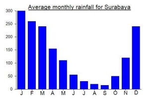
Local Average Monthly Rainfall (mm):
Location
Click on the blue arrow ![]() (top right) to see your current location on the map
(top right) to see your current location on the map
Origins and Meaning
According to Pak Ismail Lufti, Professor of Archaeology at Universitas Negeri Malang, based on Tantu Panggelaran, an ancient Javanese book, the original name for Anjasmoro was Ardikemukus, from ‘ardi‘ meaning earth, land, or mountain and ‘kemukus‘ meaning cone.
https://travel.kompas.com/read/2022/02/19/180600327/gunung-anjasmoro-di-jawa-timur-bukan-untuk-pendakian-ini-alasannya?page=all
A shocking but not surprising state of affairs.
I just recently thought of a(nother) explanation of the name Boklorobubuh. It has been suggested to refer to a woman, Mbok Roro Bubuh. But there are also two mountains in Malaysia called Gunung Bubu (named after the shape of a ‘bubu’ – a fish trap that is often made of bamboo and often rather pointy). So perhaps Bokolorobubuh is indeed from Mbok Roro Bubuh but may simply refer to a personification of the beauty of the mountain rather than to an actual human woman. An honorific title expressing gratitude at the sheer pleasure derived from looking at the shape of the mountain (especially when seen from the north, and Trowulan, the centre of the Majapahit empire).
So… Kukusan and Boklorobubuh. Perhaps not that different. A pointy rice steamer or a pointy fish trap. It’s always about food in Southeast Asia, isn’t it?
Yet another hike recently in the Anjasmoro range – perhaps my final in Java, at least for a while, as everything else on my ‘to do’ list is on other islands.
I got the brand new train service Brawijaya from Gambir, getting off at Kertosono – admittedly Jombang or Mojokerto would have been better but the Brawijaya turns down to Kediri at Kertosono and getting this new train was more important to me than being in exactly the right place!
The trek planned was a 3 dayer to Boklorobubuh (Kukusan), but given it was the rainy season I didn’t expect we would reach the top. Not to mention that the terrain there is so impossibly steep that even in perfect conditions, the sane may very wisely choose not to continue.
The Sungai Boro is a fantastic spot – wild as it gets in East Java. But getting down to it was a challenge and for the way in we were not following a path at all! Very few hikers come here – just locals looking for ‘rebung’ (anak bambu). There was a huge amount of rainfall by early evening and I really worried that the already challenging landslide area could get even more challenging in wet conditions.
The second morning we were up on the western ridge, looking to Boklorobubuh just after sunrise. Brilliant spot looking towards one of Java’s most iconic peaks. But I was happy enough not going any further, given the steepness of the terrain, especially during the rainy season, and indeed it was raining by 11am as we followed the fringes of the Sungai Boro once more.
I have a feeling the Majapahit folk may have chosen Trowulan as their capital because of the view to Boklorobubuh / Kukusan. No way to prove this of course – just a feeling. But how could they not have admired such a unique-looking mountain peak? It must have been a very familiar view to them.
Our second night was spent next to the river. I had Radiohead’s wonderful drone track ‘Treefingers’ running through my head. The final day we were out by mid-morning, after a wrong turning near the village. As luck would have it, the hotel I booked in Jombang didn’t have a room ready when I arrived, so after 3 days of no proper shower I had to wait yet another couple of hours longer!
And the trip that began with a new train service also ended with a sort-of new train service, the relaunched Bangunkarta which now runs between Jombang and Pasar Senen. Prior to departing at 5am, there was a launch event, complete with prayer, coffee, and amazingly some gifts for me, perhaps as I was the first person to purchase a ticket on the train! Thanks Kereta Api for the mask, umbrella, t-shirt and so on! A nice way to end my final trek in Java for the time being. Next up… something in Lampung!
Finally got round to hiking up Watu Jengger, something I had put off thinking it was too easy and short. In actual fact it was a very worthwhile half-day trip out. We combined it with Trowulan Majapahit Museum – great exhibits and great place, and from Kolam Segaran the range is clearly visible in good weather – maybe even the unique appearance of the range was part of the decision to have the centre of the empire here! Certainly I think a good argument could be made for Anjasmoro being the Majapahit Mountain.
For Watu Jengger, I got a Gojek from Mojokerto but he perhaps sensibly didn’t want to take his nice automatic motorbike up the last 2km to Nawangan so I got off and walked from the junction. As has been the case on almost every single of my treks of 2021 so far, I saw a kingfisher near the start of the trail.
Watu Jengger is a hike that can be done alone, especially if you have a GPS or similar, and if you do it on a weekend when you will meet other hikers. It is only a short hike but the views from Pos 2 onwards are brilliant. During the rainy season, the river down below to the west is very impressive. Boklrobubuh/Kukusan was in cloud on the way up, but halfway back down I could see it had cleared and managed a few photos from afar. There were about 20 others up there – local kids camping, mostly. It took only 1hr 15min to the summit sign and less than 1 hour back down to Nawangan where I got an ojek down towards Mojokerto. Very friendly – the ojek man’s wife gave me an orange juice while i waited for him to get changed.
Rain arrived soon after, no surprise. And after the Majapahit Museum we took ojeks back to Mojokerto but on the main road a dodgy-looking character was behaving strangely on his bike, veering close to my wife’s ojek as if he might be thinking of trying to snatch her bag. Considering the economic impact of the pandemic, you have to be a little more aware than usual right now. We caught up and shouted and the startled would-be thief shot off on his bike at high speed, clearly almost caught red-handed. I was just glad nothing bad happened – always be aware of your surroundings.
Obviously we already knew about the floods in Jakarta – the worst in many years, but at Mojokerto station it was announced that all Jakarta-bound trains were cancelled due to a flooded line at Lemah Abang near Cikarang. This is still the case and may stretch on until midweek. Anyway, I got my cash back and booked us on another train to Bandung (luckily there were still a few seats available).
As the rain had cleared up by late afternoon, Anjasmoro was clearly visible from Mojokerto train station at dusk. Very pleasant. And undoubtedly I will be back at least once more time to explore further into this range that never gets boring.
Once again had hoped to visit the Gumeng area and check out Gunung Bakal or Gunung Mrasih on the north-east edge of the range, but it seems locals there are still not keen on outsiders, especially foreigners, visiting. Another great consequence of governments worldwide terrifying their residents with a disproportionate response to the pandemic.
However, the Pacet area, and one spot in particular on the Pacet-Cangar road has stunning views towards Boklorobubuh first thing in the morning if you are lucky with the weather. Known as Wisata Bukit Gajah Mungkur and located at a very sharp bend in the road, this is the best place for anyone interested in photographing Boklorobubuh without doing any actual hiking! Best between 5 and 7am!
We were heading to Pujon for Gunung Kawi….
One of the best and most memorable hiking weekends of the year for sure – finally managed to reach the true summit of the Anjasmoro range. The original plan was to have a quick explore of the Gumeng area in the north-eastern part of the range, including taking farm ojeks up for a panoramic view, but it turned out Gumeng was closed to outsiders, so we decided to put that off until – hopefully – November.
This turned out to be quite fortunate in retrospect, as the main hike of the weekend took longer than expected. The weather was perfect –barely a cloud in the sky the entire weekend, and Mojokerto a ridiculous 37 degrees on Sunday afternoon. Not a drop of rain.
We met in Pacet early on the Saturday and sped round to Pujon via the Cangar road, which is quite lovely and very steep! Back in friendly Borah, the same place we had tried and failed previously from, and we set off on the plantation trails, with the guide already having reached Gunung Petungamolok 2 weeks previously, and seen from there it was simply a matter of following the top of the ridge all the way to the highest peak.
Anyway, beyond the carrot fields, the ridge is a mix of reeds / tall grass and patchy forest offering occasional much-appreciated shade from the scorching sun. From 1700m or so there are fine views to Semeru, and once on the Petungamolok ridge, the panorama opens out to include Butak/Kawi, Kelud, Argowayang and Gentonggowok, Arjuno-Welirang, and if it is particularly clear all the way to Gunung Liman/Wilis and Lawu out to the far west.
Petungamolok gets its name from bamboo (‘petung’) and you may have spotted a photo place on the Cangar to Pacet road called Petung Sewu. However, there is no bamboo on the top of Petungamolok – perhaps the bamboo is lower down at the the foot of the peak.
The biggest issue with the ‘trail’ is that this part of the range is so rarely used that it is completely overgrown, and the bracken-coated areas take forever to get through and even with long sleeves and trousers you will end up with numerous scratches. By mid-afternoon I was getting concerned that despite being close, as the crow flies, to the top of the highest peak, it was taking us so long to make progress due to the vegetation that we might not have sufficient time. If this was a well-used trail free of dense vegetation, reaching the top could be easily accomplished as a day hike. And this may well occur as local hikers find out about it and visit. But for the moment, you need a full day to get as close as you can to the summit, camp, enjoy the stunning views at sunrise the next morning, and then back down in time for lunch and to tend to your many scratches!
Some folk wonder why it is so important to reach the highest point. Well, thankfully, the highest peak of Anjasmoro perfects illustrates why – because you have a rarely-seen brilliant panorama of most of the entire range that is simply not possible from elsewhere. As expected, the view north to Boklorobubuh in particular is spectacular and we were so lucky with the weather – completely clear. This is wild, wild terrain, despite being not so far from very densely-populated cities. The highest peak genuinely ‘deserves’ to be the highest peak and would also make a good camp area, with lovely pine trees offering shade.
It remains nameless, as the previously suggested Sumur Windu apparently only refers to the area at the foot of the highest peak rather than the peak itself. Certainly there are no wells here, and no water sources on the entire trek except in water pipes in the plantations near the start. Locals in Borah simply call it Anjasmoro, but be aware that there are different opinions on the names of different peaks, so it is hard to compile a definitive list of peaks and locations.
This trek could be combined with the Cangar route, but be warned there are narrow sections of ridge near Gunung Biru that are crumbly and not especially safe with a large backpack. Also, the section between the highest peak and Gunung Biru is likely to be pretty overgrown, but as always it really just depends if anyone has been through in recent weeks or not! That alone will save or add hours to the estimated trek time. For now, this is a connoisseur’s peak only, but one in which the connoisseur is grandly rewarded if the weather is good.
We will have to update the trail map next year sometime!
Was supposed to be having another attempt at reaching the 2372m highpoint of the range this weekend but it was cancelled thanks to what can legitimately be described as complete chaos on the part of Kereta Api Indonesia. I am still furious as I write this, having lost money and ruined my plans, but it is almost funny just how bad the management have to be for such a thing to occur. Those accustomed to Indonesia may not find it surprising but Kereta Api have been very reliable in my experience in recent years. Very sadly, it all changed this week. As follows.
I booked a Jakarta-Surabaya train for Friday evening, returning Sunday evening. I have been keeping my eye on the services that are running as it dictates what I can do over the weekend. Anyway, every time I checked availability of trains over the last few days, the results have changed wildly from one day to the next, with train services seemingly being made available and then hastily deleted again, tickets taken offline. Very confusing for passengers, and zero clarity from Kereta Api themselves. There’s a list of services for September online, but it is wrong, which hardly helps matters.
Things came to a head on Friday afternoon when I double-checked my return journey (sadly the kind of thing that is absolutely required in Indonesia, and illustrates why it is still very much a developing country) and was shocked to see that no train services were available for Surabaya-Jakarta on Sunday. They had all been taken offline – certainly not because of being fully-booked which is almost unheard of since March. Other passengers of other services were complaining on social media, KAI not responding, and I decided to give them a call. The operator was clearly looking at the same system as me, and confirmed no trains from Surabaya to Jakarta on Sunday. Nobody had informed me about this cancellation. ‘Mohon maaf’ came the meaningless reply.
So, anyway, with no other realistic options I had to cancel my hiking plans. Craftily, the KAI app would only give me 75% of the return journey ticket price back as a refund and the outward journey was not eligible being so close to departure time. I went to bed in a bad mood at yet another lost weekend and more money wasted on companies that fail even the basic tests of usability and are quite simply inept. I was Rp800,000 under, for absolutely nothing, not including phone charges for trying to get through to them to get some clear info. Whoever is putting the tickets online as either available or not available is clearly in need of some training or strong mental health medication, for how are customers going to have any confidence in a company that keeps changing its mind and not telling anyone?
If only that were the end of the story! I woke today, checked the schedule again, and, horror of horrors, the train services back from Surabaya were available again! So I should have gone anyway and all would have been fine. The cancellation was cancelled. But it was too late for me by this point. What a farce! Mr Didiek, head of KAI, clearly needs to implement some massive changes to his workforce and perhaps the IT department. I’ve complained, so will be interesting what the response is other than ‘mohon maaf’ and that annoying prayer sign that is routinely used to somehow make up for crappy behaviour.
And even more amusingly, this meltdown Friday happened to be Hari Pelanggan Nasional – National Customer Day! The Grade 4 students that I teach could do better than this.
Congrats to Mas Jabung and co for getting some views from the top of Argowayang last weekend. They only got 5 minutes at 5pm before torrential rain for hours and hours. Nice shots though – have a look in the gallery! It is an endlessly interesting range.
Yet another great Anjasmoro weekend – this time exploring the western side of the range. The evocatively-titled Argowayang side. As usual I took a night train to East Java and we set off up to Pujon from Mojokerto. This looks close on a map but actually takes over 2 hours, but 2 rather scenic hours, winding up the mountainside into fresher and cooler air, and with a view of Gunung Kelud on the right at one point.
I actually had no idea if the approach I had in mind would work, as there was no detailed information online and I was simply using Google data and the Bakosurtanal map to assume there was a ridge trail up beyond Ngebrong. Luckily there was, and it was much clearer that I could have anticipated. Along with Mas Jabung and friends, we reached the peak in 4 hours. Pretty wet by the time we got to the puncak, with thunder surrounding us, and only limited views due to the weather, but we had done it! I hope others will visit soon and I look forward to seeing photos of the view from the top.
There is no reason why this trail could not be turned into a proper hiking trail, but at present it is only used occasionally by local villagers rather than hikers.The mosque down in Ngebrong is truly beautiful – perhaps my favourite in all of Indonesia. I wonder when it was built.
Next we set off for Galengdowo – again, close on the map but nearly 90 minutes to reach skirting round the mountain range on motorbikes. Pak Endon was waiting and it was an early night and early start the following day at 3am up to Tapak Bunder.
We took the bike in to around 900m or so, so not much elevation gain needed to reach the top at 1,482m. However the first steep, muddy section is tough going until the ridge is reached. We were at the top for 6am, around 2 and a half hours at a leisurely pace, and the view to Boklorobubuh was superb. But it was lucky we started so early as the cloud rolled in just 30 minutes after we go to the top. Then it was straight back down and to Jombang station for the lunchtime train back to Jakarta.I see there is now a train named after the range… Kereta Api Anjasmoro from Jombang to Pasar Senen.
Thanks to Pak Endon, Mas Jabung and friends.
Bukit Semar certainly did not disappoint yesterday morning at sunrise. A great viewpoint, and especially with our short-cut up to Pos 3 along the private road it was very easy indeed.
Pak Paiman from Dilem basecamp picked me up at my hotel in Pacet at 2am and we were off. As we had limited time (I was booked on a train at 11am from Mojokerto which is the nearest train station) he decided that we could use the private road in from the north. There is a metal gate at security post but the guy was asleep and didn’t seem to be able to be roused, so we just went ahead anyway, the motorbike easily narrow enough to get round the gate. Farm workers use this road, but it seems to be a grey area for tourism.
Anyway, once up at the top of the road there is a house, and you can get behind this on the left side and onto the pleasant forest trail. Even a normal motorbike is fine for this – during the dry season anyway. We left the bike at around 689m, beyond Pos 3, which is where the regular trekking route comes up to meet the ridge. We took it very easily and it only took an hour or so to get to the top.
There must have been 30 or 40 locals camping up there. It was before 4am so we had nearly an hour to wait for light, but luckily we were given coffee by a guy who recognized me from the social media for the nearby Rejosari trail up to Puncak Semar (very different to Bukit Semar despite the very similar name).
Once the sun was up we took a wander a little further along the overgrown and crumbly ridge to a couple of spots a similar height to Bukit Semar (930m ish) for photos of Watu Candi on the next ridge to the west. This is a natural rock buttress formation. We could also see Gunung Buthak, the 800m+ peak near Blentreng which seems to be a rival viewpoint to Bukit Semar (but is a bit lower in elevation). As the sun hit Kukusan and Boklorobubuh I went into overload with my camera. This is the time to be up here – start hiking after sunrise and it could well already be hazy or cloudy by the time you are up here, especially if doing the proper trek rather than the short-cut in to Pos 3.
Just two weeks on from my trip to Puncak Semar and I hear (and see) that the ridge is on fire. How many of Java’s mountains have not been affected this year? Arjuno-Welirang was ablaze earlier this week, and now the northern hills of Anjasmoro near Rejosari. Very sad indeed. Thankfully, a little rain has arrived this evening.
The rainy season cannot come soon enough this year.
And, just a few days later, Puncak Cemorosewu is ablaze too.
https://m.jatimtimes.com/baca/203063/20191016/195100/pasca-kebakaran-hutan-jalur-pendakian-gunung-anjasmoro-jombang-ditutup/
Fantastic weekend hiking the Rejosari route on Anjasmoro – perhaps the route that best lets you understand the geography of the whole range because it is central and has views to most of the other principal peaks in the range.
Mojokerto and Jombang are not the easiest places to get to from Jakarta on a Friday night after work unless you either fly to Surabaya (expensive) or can manage to get out of work early and get on the Bima train at 1630 from Gambir. Second best option is the newly-available executive seats on the Brantas which leaves Pasar Senen station at 1700 and is almost half the price of the expensive Gajayana from Gambir which leaves a little later from Gambir. Alas, neither of these go via Jombang and Mojokerto but turn south after Kertosono towards Kediri and Blitar, so you need to sort out transport onwards from Kertosono at around 6am.
Pak Faisal is doing a lot to promote this area and he very kindly picked me up at Kertosono on his motorbike and we sped off via Jombang to the Rejosari trailhead. About 90 minutes in total. On the way near Jombang, fields were being burned by farmers, clearing the way for the next lot of planting, and creating waves of smoke drifting across the main road. With all the news from Kalimantan and Sumatra recently you would think there would be increased awareness about how harmful this practice is. I wondered if the haze would affect the hike and the views from the ridges – thankfully we had pretty excellent weather, particularly on the second day.
Local guy Suki was waiting for me at the basecamp warung next to the small river in one of the ‘North Gate of Anjasmoro’ t-shirts. We were off by 8am, following the track steeply up the hillside. Most folk who come on this trail are just visiting the relatively nearby Coban Bidadari (waterfall), so follow any signs for that. Once on the ridge, the trekking is very pleasant, but do watch out for snakes as we saw two on our ascent. This just shows how wild the Anjasmoro area is for Java, as I think I have only once before encountered two snakes on a hike in Java (Gunung Malabar south of Bandung in West Java).
It is quite normal to hear (and usually see) hornbills in this area too. Another rare sight in Java these days.
Despite my trepidation after the previous failure on the Blenteng route, I was pleasantly surprised that we managed to reach Puncak Semar in just 3 hours and 40 minutes, including a couple of very short rests. This would definitely have been longer if we had been carrying tents up, but thankfully a group was already up there waiting for us, comprised of Ojek Adventure and Anjasmoro Basecamp volunteers.
It was cloudy by the time we arrived, quite normal by late morning, and indeed the ridges of Anjasmoro are known for not being high enough to be above the cloud like the 3000m plus peaks, but rather often in the clouds and therefore without views. That’s why camping is the best idea if you want to see the incredible panorama beyond Puncak Semar.
From this spot, you can peer down into the wide, forested valley between here and Cemorosewu and Argowayang – the two main mountains that form the western buttress of the range. This valley is where those attempting to summit Boklorobubuh trek, via Kali Pait – the bitter stream. According to a co-hiker, the water in this stream really does taste bitter for some reason! At times I was sure I could hear the river from Puncak Semar.
After a quick snack for lunch, we decided to explore a bit further along the ridge. Puncak Bayangan was pretty straightforward aside from the exposed step that is quite simple if you have a wiry Indonesian guy to pull you up! Then it is a quite exhilirating 20 minutes up to the top. We had a few glimpses of the valley below and it was very atmospheric with cloud swirling over the narrow, grassy ridge. Beyond Puncak Bayangan (which one friend says is also called Sigiran) the terrain is a little more challenging, with a narrow, exposed ridge. Gunung Kukusan was perhaps under one hour away, but I was concerned about the safety of continuing along this part of the ridge and we would have no view today anyway. I salute anyone who has been up Kukusan via this ridge, but it is just a little beyond what I am (and probably most are) comfortable with.
Back at camp we had a brief 5 minute window of great weather at around sunset before we called it a night. One of my favourite sounds is the incredibly subtle and gentle breeze blowing through the pine trees near the top of several East Javan peaks, but overnight this sound was pretty powerful and loud – winds were blowing quite strongly though Puncak Semar seemed sheltered where we were and it was just the sound itself.
These winds turned out to be brilliant for the following day’s weather….. perfect blue skies with almost no cloud. Once again, some of us headed off to Puncak Bayangan for sunrise. Absolutely brilliant.
The fastest of our group were back down at Rejosari in just 2 hours and 30 minutes. Many thanks indeed to all who came on this trip and also to Pak Faisal for arranging it and his friend for letting my try the local Kabegjan coffee which I am looking forward to. I wholeheartedly recommend the Rejosari trail expecially for those who like a bit of solitude.
This was my 5th trek in the Anjasmoro range and probably my favourite. The range always leaves you wanting to return. Whereas most mountains in Java can be ‘understood’ in one hike, perhaps trekking up one route and down the other side, Anjasmoro is completely different – and it isn’t even a Ribu!
The views from the train into Surabaya Gubeng were also great – Anjasmoro, Penanggungan and Welirang all perfectly free of cloud.
I’ll be back in December for a quick exploration of the southwestern corner of the range.
Thank you Mr. Dan Quinn for the credit of Ojek Adventure and the volunteers of Sahabat Anjasmoro. We are happy to see more responsible hikers coming to Puncak Semar via Rejosari Basecamp.
Made an attempt on Anjasmoro’s highest peak from the villages above Pujon last weekend with a couple of guys from the northern side of the range near Mojokerto who were keen to try a hike from this side. Sadly Sriwijaya have recently cancelled their early morning flight to Malang, so I had to get the 15 and half hour Gajayana train from Gambir.
Meeting point was the mosque (Al Mustain) marked on Google Maps up beyond Wiyurejo, Pujon. We used bikes because there is a bridge under repair meaning a car cannot reach the end of the road (not to mention it is hard to find a parking area up there). Unfortunately, whoever has labelled Al Mustain mosque on google maps has got the location wrong. It is over 1km earlier than expected in Wiyurejo itself. We continued up to the location on the map and found a new mosque under construction next to the small warung in Borah village. Anyway, this was our starting point. Friendly locals, but clearly surprised to see foreigners and even local hikers rarely use this side of the range.
Our guides had a simple map drawn by a local, showing the way to get into the forest from Borah. There are tens of different paths in the plantations with a junction every few hundred metres, making it quite difficult to know which way to go. It was surprising to see how far up the land was being cultivated with potatoes, chili, cabbage, carrot and so on. Lots of farm workers coming back down as we were heading up, and they all encouraged us to stay left (west) which was the opposite of what my feelings were as the highest peak is on the right (east) of the river we were following. They were also calling the mountain here ‘Argowayang’ which really confuses things are you wonder if you are talking about the same peak (Argowayang would be better attempted several km further west) so I started talking about Gunung Biru to try to clear things up as we wanted to be heading in the direction of Gunung Biru.
We should almost certainly have taken the right at the beginning rather than heading up on the left, as when we descended we came back down this way after following a water pipe.
Anyway, we crossed the river at 1,485m and then followed a very narrow trail through scrub that was totally overgrown. After fighting with undergrowth for an hour we emerged at a well-cut trail sloping round the mountainside following a white waterpipe. We followed this for a while but it was not leading higher up than around 1,615m and when it started leading downhill we decided to try to follow a very vague path on the right, in the direction of the peak (still over 2.5km away – a long distance when there is no trail). After 30 mins of tough going, we found ourselves on a ridge (1,700m) and amazingly it had a reasonable path that had obviously been used at some point. Having been worried we would not make it after so much wasted time (already nearly 4 hours from the village due to trail confusion and dense vegetation) it now looked like we were on a ridge trail that might even lead us all the way up to the top.
Sadly, this was not to be as we soon met a large cluster of rocks. Our guides got up this in 15 seconds, but we needed their rope to help pull ourselves up. Beyond these rocks there was no longer any trail – rather strange for there to be a trail up to some rocks and then nothing beyond. But we continued upwards, making slow progress. In less than 5 minutes we met some more rocks, actually a more considerable cliff. Once again, the guides could get up this, but even with ropes there appeared no way for us to manage it, as there were no big trees to hang a rope off and the drops on both side were considerable. We looked for way round the rocks but couldn’t find them.
As it was now 430pm, we had been hiking for nearly 5 hours and had less than an hour of daylight left and had seen no flat spaces for camping since the plantation trails and water pipe trail. We were at 1,800m and still 2,15km from the peak – so even if we got up the cliff there would be almost no chance we would reach the true summit in the time we had (as always with me having to get back to Jakarta the following afternoon) since there appeared to be no trail beyond the cliff anyway. And we didn’t want to be stuck in the dark above the first rock that needed real care, so we decided to descend to the water pipe trail curving round the side of the mountain.
Once down, the choice was camp here, stay in the village or head home, and given it was only early evening, we decided to follow the water pipe back down the hillside. This was a much easier route that the made-up one we used on our ascent and we were back in plantation trails in no time. It took us less than 2 hours from the cliffs at 1,800m back down to Borah at 1,260m. Had we come up this way in the first place we might have had more options. As it was, me and Jon decided to head back to Malang rather than camp out for no reason as we wouldn’t have time for a second shot the next day. I did spot two minor trail junctions off the water pipe trail, but it is unclear if either of them lead up to the higher slopes of the ridge of simply petered out as so often happens when these paths are not routinely used.
So the question remains how best one can get onto the ridge from this side of the range without meeting the rather dangerous cliffs. There may well be a spur leading up further east of the waterpipe trail. Once up at 1,900m the ridge looks a bit flatter on the maps and more suitable for camping in several places but it is likely to be pretty overgrown to say the least.
When we got back to the house we had left our bikes at, they invited us in for a coffee and chat. The older man suggested that the name of the peak was Sumur Windu, perhaps because there is a well of some sort at or near the summit. I couldn’t be sure we were talking about the same peak, but it seemed reasonably likely as he spoke about hiking over to Anjasmoro peak many years ago. He said if he left his house at 5am he would reach Anjasmoro peak (near Cangar, presumably) at 10am. I said 5 hours was incredibly fast and he said it would be 10am the following morning so not 5 hours but 29 hours! He also said he had taken a westerner up there several decades ago.
But it remains unclear if there are other decent routes into the forest other than the one we descended by (the water pipe one). I think the best chance of success from here is to get a local person who can help from Borah village, and try to stay right and find another way up to the ridge that avoids the minor cliffs on the slopes we ascended via. It could of course be that we turned up the hillside too soon and that if we had followed the pipe trail further into the mountains then we might have spotted another path up into the forest and the higher slopes of the range. Lots of maybes. The guides say they’ll try again sometime so it’ll be interesting to hear of any developments. For now it remains one of Java’s most impenetrable areas. Anyone thinking of trying this can use my GPS tracks to know where NOT to go!
Great article on the names, history and legends associated with Anjasmoro…… from a really good local website….
http://jombangcityguide.blogspot.com/2019/07/legenda-joko-mujung-dan-sang.html
Spent last weekend doing two hikes on the Anjasmoro range, both from the north. This was quite a mad weekend from Jakarta requiring two nights sleeping on long distance trains! Many thanks to the very helpful writer of Jombang City Guide website who put me in touch with some friends of hers who helped with logistics and guiding.
Arrived in Jombang before 5am on the Saturday and Pak Endon was waiting so we could go directly up to Carangwulung for a morning hike up to Puncak Cemoro Sewu. On the way there, as dawn was breaking, I could see the steep triangular-shaped peak of Boklorobubuh in the distance (the one that many people here seem to call Kukusan).
Cak Kancil was waiting at the registration booth with a friend of his – both very friendly folk. We set off up the hillside not long after 6am and were at the top in just over 3 hours. Whereas I had been expected a fairly average hike and not especially outstanding views, I was actually incredibly impressed and would say so far it’s my favourite of the 3 Anjasmoro hikes I have done. The peak may only be 1,866m or thereabouts, but an early morning hike up here in clear weather is just delightful. Lovely views, a great and enthusiastic guide (thanks for the jambu straight off the tree!) and a clear trail made it an experience I will treasure for a long time. Given the fairly easy nature of the hike, this ought to be much more popular – but best either camp or get there as early as possible for decent views.
We spent a bit too long enjoying the views at the top actually, as the clock was ticking and we had to get to Desa Jabung to meet Mas Jabung (!) and friends for a hike up in the direction of Gunung Semar and Kukusan from Blentreng. Yes a second hike the same day, but we would be camping up on the ridge.
This was to be the more demanding of the two treks by a long way, as it is not often hiked and the terrain is tougher. I had basically wanted to get as close as possible to Boklorobubuh from the northern end as I possibly could do in the time available. Due to the terrain on this side, most groups take at least two full days, and usually 3 or 4.
The choice was whether to start in Rejosari or try something more ‘experimental’ such as the Blentreng route, as obviously I wouldn’t have enough time to actually reach the top of Boklorobubuh from Nawangan as this is a 3 or 4 day affair. So the aim would be to reach Gunung Semar, which is around about where the few photos were taken of a local hiker standing with Boklorobubuh as the background. That would be good enough, I thought.
After much chatting back and forth it was decided to try the Blentreng route as the Rejosari trail sounded longer and more time consuming. I also sent Rp500,000 ahead to pay for a local person to ‘buka jalur’ (open the path) so that we would be up there as fast as possible. This isn’t something I have done before as it required a large amount of faith, and sadly after this experience I doubt I will ever do it again, at least not in Indonesia! Faith is not always a positive.
We took the bikes deep into the valley beyond Blentreng, up what is really just a bouldery path. It may have saved us a bit of time (an hour?) but not a lot. It was very surprising to come upon the Mbah Setro grave site and a handful of local people there in the middle of bamboo forest – despite being not too far from Surabaya as the crow flies this is remote country.
The track up on to the ridge is clearly well used and well established by local people hunting. There is a well-trodden path, but it is not always easy to see, with shoulder-length vegetation such as grass obscuring the way. If someone had cleared the trail here a few days previously then it really hadn’t provided us with any benefit as it was taking a long time to cover very short distances simply because of the terrain. You can barely see your feet. Similar to how Gunung Liman was when I visited it many many years ago. It’s amazing how the terrain can slow you down from 5km an hour to just 1km an hour! And I was a bit concerned that my money had just been a waste as I can’t honestly say we got much benefit from whatever work, if any, that local person did.
The views from the ridge, however, were great. A little cloudy in the late afternoon, but Penanggungan visible over the many lower ridges further east. I spotted a large bird higher up the ridge we were on (the ridge west of the Blentreng valley) and a few blurry photos confirmed it was a hornbill. Not something I see often in Java sadly so really nice to see one here.
The guides set up camp at around 1,210m, in one of the few vaguely flat spots available, and it seemed that if we set off before light the next morning then we ought to be able to get to Gunung Semar (1,708m) and back in time for me to descend and get to Mojokerto train station for the long ride back to Jakarta. Even with terrain that keeps you moving ever so slowly. At night I heard a hornbill flapping its wings as it flew over our camp.
Pak Endon perhaps wisely decided to stay at the camp the next morning, presumably due to being knackered after doing two hikes the day before! The rest of us carried on up the ridge with torches. Just 15 minutes beyond camp we reached the small cliff the guides had mentioned before. Theres no way round it – you have to find a way up if you want to continue up the ridge. The locals were fine and up in no time. But I couldn’t do it.
It’s a rising narrow ledge, with grass growing on it, a considerable steep drop on the right side and the rock on the left side offering precious little to grab on to. Maybe I was being too cautious, but being heavier and wider than the locals I knew this was going to be riskier for me and that I had to be at work in Jakarta the following morning at 7am rather than in a Surabaya hospital bed or worse. You can’t even clearly see what is solid and what is just earth or vegetation but a fall would definitely cause serious injury. And then you have to get back down the same way again later!
I did get some lovely photos of Penanggungan and Welirang at sunrise. It didn’t make up for coming to a halt at just 530am though, especially after so much planning. A rope would have solved this problem. If only we had one…. Either fixed in place or in one of our bags. As it was I couldn’t make it. Very frustrating and disappointing to have come all this way and be beaten by an exposed ledge just a few inches too narrow. But not worth dying for.
And so we were back down in Blentreng by mid-morning and I spent lunchtime in Mojokerto waiting for my train, which thankfully was perfectly on time upon arrival 12 hours later at Gambir.
I’m not sure whether I would try again using this route unless it became more established. Perhaps Rejosari is a safer bet, but then again maybe not. With these more obscure peaks you have to visit first, spend your money, hope for the best and then find out!
Next Anjasmoro hike will be an attempt to reach the highest peak from the Pujon area in September. One night camping at the top with views of Boklorobubuh (hopefully).
Well, after a fair bit of messaging back and forth to locals regarding various peaks in the range and looking at various maps, it seems I will have to make at least 2 more weekend trips to Anjasmoro in 2019. One to do Gunung Gede / Cemorosewu (dayhike) and then a Kukusan / Boklorobubuh investigation the following day, and then another separate weekend trying to reach the true 2372m seemingly un-named summit of the entire range near Pujon…..
Thanks to Cherry Zoya of the excellent Jombang City Guide website for putting me in touch with some knowledgeable locals….
Anjasmoro was the last mountain in Java for me to explore (other than Gunung Baluran, which the National Park forbid people from hiking) and after the recent trip last weekend I feel I need at least two more trips to its numerous peaks and ridges to get a proper understanding of it.
7 of us (including 2 local guides) set off from Cangar on Saturday morning after having got any last minute necessities from the Indomaret at Sumber Brantas (1,620m). The first section is pretty tough – very steep – but you soon reach the ridge, which was misty for us. From here, the trek is basically following ridges, some of which are narrow (easy for navigation but dangerous!) and some of which are wider (safer but harder to navigate). The first top with a sign on it is often mistaken for the top of Anjasmoro, but it is not the top of even the peak known as Anjasmoro, let alone the mountain range itself. But at least there’s a sign – the rest of the range feels very far from civilization, and hiking here alone might be a little spooky in the mist, apart from at this end where you can hear dangdut booming in the valley below!
We were all at the top of Anjasmoro peak (just the peak, not the highest point of the range) in just over 2 hours. In addition to an Indonesian flag, there was a message from a University hiking group from Jakarta who visited here in September. Not sure if they ventured beyond this point – most definitely do not.
We did though, and with the expert help of our guide Ladi, descended tough, steep, and sometimes spiky terrain before reaching the ridge junction after a further hour. Not easy at all – a few bits of ribbon on trees here and there but clearly very few folk currently hike here. The closest thing it reminded me of was Gunung Liman – another wild, unfrequented, overgrown East Java ridge.
The plan was to camp at Gunung Biru and make an attempt to reach the far western distant peak which is the highest at 2,372m but has no known name at present. Well, after another hour we reached the beginning of Gunung Biru – a lovely narrow flat ridge Ladi had visited before and suggested as a camp spot. Great suggestion – in clearer weather this would have been a superb vantage point for numerous mountains. But we had late November cloud and went to bed early.
The next morning, nobody else except Ladi and myself wanted to try for the true peak. Sensible perhaps, as the terrain beyond the camp spot was challenging indeed. Had there been a trail, we might have made it to the true summit in 90 minutes. As it was, it took us one hour to reach the highest peak of Gunung Biru, the second highest peak in the entire range but still well over 1km away from the true summit, which could be seen from the top. Nice views.
It then emerged that Ladi had done all these tops as a day-hike traverse about 4 years ago. It didn’t look like anyone had been here in recent months looking at the height of the bracken and total lack of discernible path. We weren’t going to have enough time to get over to the true peak and then back over and out to Cangar again, especially as I had to catch a train to Sidoarjo and then a flight back to Jakarta the next morning.
But if Ladi had descended to Pujon after his hike across all of these peaks, then surely it would be possible to come back next year and head up to the true peak from the Pujon side and back down the same way. That indeed is our plan. Once you are beyond the little camp spot at the start of Gunung Biru, you have a long way back to go to Cangar, with lots of ups and downs, so better to do a full traverse starting at 6am with a daypack or else do two completely separate hikes.
So then, 2 more weekend Anjasmoro hikes for 2019…. True peak from Pujon, and the Wonosalam route in the north-west of the range. Looking forward to them both….
We finished our trip in the only way possible in Malang…. Food and beverages at the excellent The Library which I wholeheartedly recommend. If only they had a branch in South Jakarta…