
Facts
- Elevation: 1,724 m (5,656 ft)
- Prominence: 938 m
- Peak category:
 Spesial
 - Province:
 Jawa Timur (East Java)
 - Coordinates: -7.9348, 112.3139
- Rating:

 (12 votes) Add your rating
 Loading...
 - Other names: ꦏꦼꦭꦸꦢ꧀ Also sometimes spelt ‘Kelut’.
- Eruptions: 1548, 1586, 1641, 1716, 1752, 1771, 1776, 1785, 1811, 1825-26, 1835, 1848, 1864, 1901, 1919-20, 1951, 1966-67, 1990, 2007-08, 2014
Photos


Bagging It!
This mountain is one of the most active and dangerous volcanoes in Indonesia. A large eruption in 1919 killed approximately 5,000 people and a more recent eruption in 2007-8 resulted in the crater’s pleasant blue lake being replaced with a vast lava dome. In February 2014, a huge eruption occurred two days after local people reported animals fleeing from the surrounding forests. International airports in Central and East Java were closed as ash rained down over a wide area. 200,000 people were told to evacuate. No surprise then that the Kelud area is often closed and constantly monitored by volcanologists. By 2015 or so, the lake had returned, but who knows how long it will be before the next lava dome emerges to displace it once more?
During quiet times, it is a popular place for local people at weekends since there is a good quality road leading all the way to the crater where until 2014 there were lots of small stalls, and some hot springs in the river below the crater. The road is open again (in 2018) but it remains unclear if cars can reach the same parking spot as in previous years and it does not look like many warungs have re-opened yet, their owners perhaps rightly being concerned about another future eruption.
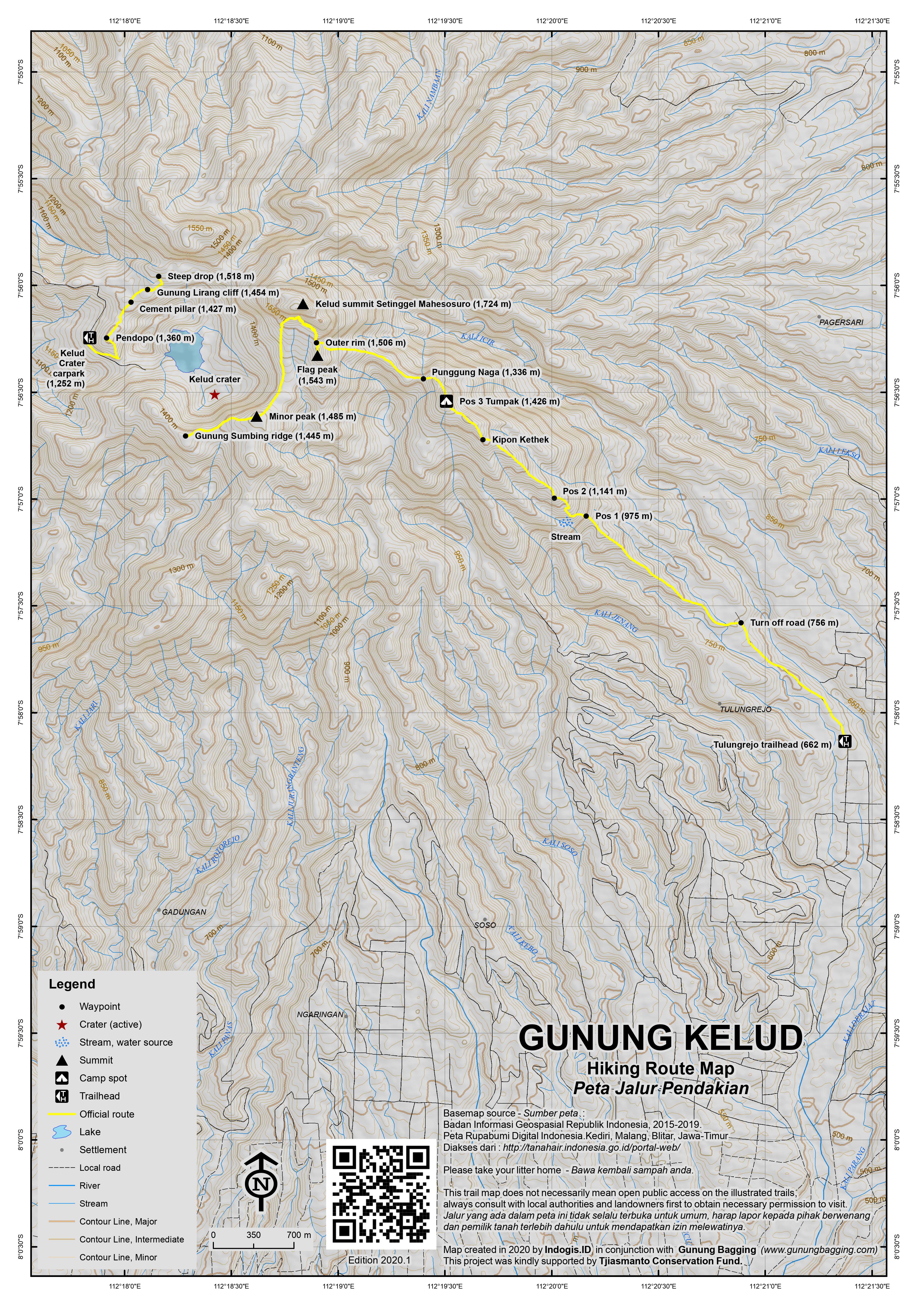
Most visitors come from the west via Ngancar from the city of Kediri – where there is a good range of hotels – but Blitar also makes a good base though the roads are slighter lower in quality. It takes just over an hour to reach the crater (1,252m) by car or motorbike from Kediri or Blitar and there are numerous signs for the mountain on the routes. The entrance point is the village of Sugih Waras. About a mile beyond the village is the Volcanology Post. From here the road leads for another 10km to the crater area whose jagged outline is visible for many many miles. There are places along the way to stop for basic snacks and fuel. At the end of the road is a place to park motorbikes and a signpost for a right turn down to a hot water bathing area. Straight on leads through a dark but flat tunnel – known locally as ‘the channel tunnel’ – before emerging a few metres above the new lava dome (or, since 2014, lake). There is an incredibly impressive rockface on the right – Gunung Sumbing (1,506m) – which is a great place for rock-climbing but totally impossible for regular hikers to scale. Photos online suggest that at least one group of experienced climbers have made it to the top.
The steep and jagged crater rim is a fascinating area – the true Kelud peak is the huge vertical chunk of rock with a couple of pinnacles at the far side of the crater. Local hikers reached the top, known locally as Setinggel Mahesosuro, in both 2018 and 2019. According to these local hiking enthusiasts, it is a daunting task requiring rock climbing skills and ropes.
There are basically three main hiking routes on the mountain. From the crater carpark, beyond the tunnel, there are cement steps up to the left of the crater (in the direction of minor crater rim peak Gunung Lirang) towards a small pendopo (1,360m) (unsure if this still exists post-2014 eruption). This is about as far as most visitors to Kelud venture and ask them if they’ve been to the puncak – ‘peak’ and if they’ve been here they’ll probably say yes! From this small roofed structure, perched on the rim, a trail continues some way along the rim beyond a small cement pillar (1,427m) towards the true peak. After a few minor ups and downs, a small rock crag is reached (1,454m). To get beyond it, skirt round to the left of it and watch out for holes in the ground beneath any foliage!
From the top of this crag the views towards the true Kelud peak are astounding – it appears as an impenetrable castle of rock with impressive rocky turrets crowning it off. The trail continues to a slightly higher part of the rim (1,518m) after which is a vast drop between this part of the rim and the next peak. Even for skilled rock climbers this would be a tough proposition and for any ordinary hiker it’s totally impossible. This hikes does, however, offer some of the most excellent views of Kelud peak, Sumbing rock-face and the crater below. It’s a short morning stroll.
There is a second approach from this side, but it is difficult! There is a vague and rarely-used trail which skirts to the right below the Sumbing cliffs and then up onto a fairly flat ridge. Finding this trail is quite difficult and staff at the crater car park or office will definitely try to make you take an over-priced guide with you. It may be worth a try if you want to reach the summit area from this side.
The best approach, however, is from the east at Tulungrejo on the small road running north-south between Kelud and Butak mountain ranges. Although this route is longer, you have the advantage of being able to start at whatever time you like (instead of having to wait until the crater road gates are open) and you won’t have any hassle from staff hoping to make a quick buck from a ‘tourist’. If you set out early, this hike could be done comfortably as a day-hike. It takes just under an hour to reach Tulungrejo from Blitar or just 25 minutes from the railway station at Wlingi.
Once in the village, take a left past the mosque and then up to the right on a road which runs above an impressive wide river. This was an obscure hike back in 2011, but fast forward to 2018 and there is a dedicated parking area, ticket office and several warungs (662m). Local guides used to be essential in order to find the starting point but the route is now clearly marked and on most weekends there will be many local students hiking and camping too. Be warned that although it is technically possible to traverse the mountain and reach the warungs and crater car park on the Kediri side from this side it appears that very few people do this and it is customary to return the same way. Do take plenty of water and snacks with you.
From the ticket office and parking area, you can either simply follow the road on foot for 20 minutes or take an ojek Rp5,000 or Rp10,000 maximum (2018) to the proper trailhead on the left side of the road (756m). This small trail drops down a little before leading very clearly through pine forest on a pleasant ridge (709m). After40 minutes or so you will have reached a brand new pleasant shelter – Pos 1 (975m). The last reliable water source is near here (you should be able to hear a small river a little further on and to the left of the main trail). In previous years, this trail was not often used by hikers, but it has always been well-defined thanks to the local farmers and hunters who use it. The biggest danger on this route is leeches – sometimes there are lots and sometimes you may pass by totally unscathed, especially during dry weather! In wet weather, be sure to check your boots and socks every ten minutes or so. This area of the mountain is known as Hutan Glimbung.
In 2018, Pos 2 (1,141m) is a simple but pleasant shelter less than 30 minutes from Pos 1. From here, the trail continues to rise gently via an area known as Kipon Kethek which has a few views north towards Waduk Selorejo (Selorejo Reservoir) and after about 2 or 2.5 hours in total from the very start you should have reached the top of outlying peak Gunung Tumpak (1,426m).
In 2018 Tumpak is now the favoured campsite by the many local students who come here especially during weekends. It is not unusual for this section of trail to be covered with tents sheltering well over 100 hikers. If you are lucky with the weather, you will see the dramatic vertical cliffs of the peak of Kelud beyond. Note that Gunung Tumpak is no longer the most well-known name for this spot. It is, in 2018, known as Pos 3 or Puncak Bayangan or simply Basecamp.
From Gunung Tumpak, the trail descends steeply before following the crest of a very narrow ridge – take extra special care here – which is known as Punggung Naga (Dragon’s Back). The trail them leads upwards towards the col on the left of the vertical cliffs of Kelud, some of which until 2014 were covered with a deep red lichen but have since been completely burnt off. From Tumpak to the col takes about one hour and the col (1,506m) marks the edge or outer rim of the crater area and, post 2014, the end of vegetation. There used to be a boundary marker pillar here and the ground used to have sufficient vegetation to make camping here the best option (although the space is limited to about 5 tents). However, since 2014, the area is devoid of much vegetation, and the ground is gravelly meaning a decent mat beneath your sleeping bag is very useful indeed.
From this point, the panorama to the west suddenly appears before you and the cliffs of Gunung Sumbing are visible on the other side of the crater. From the col, it’s still more than another 200m of height gain to the true peak which lies just to the right and according to local people nobody has truly gotten to the very top – please contact us if you have! The lower cliffs used to be overgrown before the 2014 eruption but even now their steepness means that very few who visit this point will even contemplate trying to scale them. However, it certainly looks negotiable if there were ropes on the higher sections.
If, like most sane people, you don’t fancy trying to clamber your way up the summit cliffs, it is definitely worth wandering over to the inner rim and peering over at the lava dome. A reasonably well-defined little trail leads up towards the summit cliffs (which it stays close to) and drops down into a few crevices and over a few small roped sections of rock before bringing you out after just 15 minutes on the edge of the inner rim – the real crater rim of Kelud. From here you will be able to gaze over one of the world’s most dangerous craters and – during the daytime – watch visitors emerge from the tunnels from the car park on the other side of the volcano. It’s a great panorama.
You can contimue all the way along the crater rim via a minor top (1,485m) over to the ridge near Sumbing cliffs, but do take real care as the drops down to one side into the crater are near-vertical and the trail gets fainter and fainter which could present a problem in low cloud. It takes about one hour to walk from the Tulungrejo col to the Sumbing cliffs (and one hour back again). There appears to be a faint trail leading round the back of Sumbing cliffs (and presumably eventually down to the Kediri side or crater road) but it is not customary to do a traverse in 2018 and you really would need a guide if you wanted to try it.
Back near the Tulungrejo col / outer rim junction, an alternative viewpoint is the little top just metres away from the col. It only takes five minutes to reach the rocky little top (1,543m) which in 2018 had an Indonesian flag on it. You can admire the view to Gunung Butak and other mountains to the east from here. It’s a good sunset and sunrise spot. In 2013, you could see the top part of the lava dome from here but post-eruption you cannot quite see the lake.
After admiring the panorama, it takes 3 hours or less to descend to Tulungrejo from the edge of the crater area.
There is apparently an even newer trekking route to Kelud from the south at Karangrejo. It sounds as if this is rarely hiked at present and potentially more challenging than the Tulungrejo route. Perhaps one for the connoisseurs only. It appears to meet reach the crater rim somewhere between the Tulungrejo col and the Sumbing cliffs ridge, most probably at the minor 1,485m top. Do leave a comment below if you have tried this route.
Bagging information by Daniel Quinn (last updated November 2019).
Trail Map
For a high quality PDF version of this and other trail maps, please download from our Trail Maps page.
Practicalities
- Getting there: For domestic flights from or to East Java, such as the airports in Surabaya, Malang and Banyuwangi, we recommend Baolau. For Tulungrejo you would need private transport or ojeks from the main Blitar-Malang road up via Semen. In 2018, ojeks cost around Rp40-50,000 each from Tulungrejo to Wlingi (one way) so presumably the same in the opposite direction. Some executive class trains (.e.g the Gajayana which runs between Jakarta and Malang) stop at the pleasant little station at Wlingi, which is the ideal place to get off at if you are hiking from Tulungrejo. Ojeks to the crater car park can be arranged from Blitar or Kediri. Public transport would take longer.
- Guides and GPS Tracks: Want a PDF version for your phone? Looking for a guide? Need GPS tracks and waypoints? Gunung Kelud information pack can be downloaded here.
- Trip planning assistance: Would you like Gunung Bagging to personally help you in arranging your whole trip? Please contact us here.
- Permits: Rp15,000 per person at Tulungrejo, though foreigners may be asked for more. If you have a KITAS or KITAP you are encouraged to argue your case as you presumably already pay lots of local taxes. Ticket price at the entrance to the crate road from the Kediri side is unknown (2018) but gates are probably not opened until 7 or 8am.
- Water sources: There were plenty of warungs selling drinks at the crater car park prior to the 2014 eruption but it remains unclear if many of these have re-opened yet by 2018. On the Tulungrejo route there is a stream at 1,002 m just beyond Pos 1.
- Accommodation: Try the Booking.com map above or use this link to search for suitable hotels, homestays, resorts and apartments for your trip.
- We recommend Safety Wing as travel insurance for overseas travellers and tourists hiking up to elevations not exceeding 4500 metres.
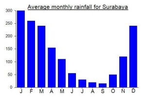
Local Average Monthly Rainfall (mm):
Location
Click on the blue arrow ![]() (top right) to see your current location on the map
(top right) to see your current location on the map
Origins and Meaning
(not clear, possibly) Old-Man Mountain. One of the meanings of kelud in Old Javanese is “old and decrepit” so it is possible that the name Gunung Kelud reflects a perception that the mountain is an ancient, ancestral entity. In modern Javanese kelud means “a feather duster” so it is possible (though I think unlikely) that Gunung Kelud is “that which sweeps through everything (when it erupts).” (George Quinn, 2011)
It sounds like the Tulungrejo trail is currently closed. Until when is unclear, as usual! Best avoid until it re-opens and please never hike without a local guide.
The below is from Michel who was up there recently:
“Here’s a few updates for you regarding the trail:
first off, the trail seems to be officially closed. I’m not sure if this is still 100% up to date but since there were no people around, except some that were managing their warungs, even after I came back down at 2pm I assume it is. Attached a photo of the trail head poster.
From start to Pos1 the trail is unchanged, open and quite wide up until just before Pos1 where it is quite overgrown. Pos1 still has its nice hut.
Right after Pos1 is gets interesting because the main path has been cut off – believe fallen tree. Thought that was it already but luckily there’s a small self-made path around it through the bushes that can be used to continue onto Pos2. Less wide but still mostly open. No need for a stick up until there but useful no doubt. Pos2 also has a small hut still.
Then onto Pos3, several overgrown places along the trail and some spots where path gets narrow due to earth slides but nothing major if you’ve got at least a bit of hiking experience. No more hut at Pos3 unfortunately though don’t think there ever was one.
From Pos3 down across the dragon’s back ridge: ropes along the downhill still exist – though not really needed going down, mostly used on the way back. The ridge itself is very overgrown. Watch your step or you might regret it at some spots. Just prior the last 500m uphill towards the crater rim, there’s a small clearing where a small trail meets the main one. Behind that starts the real fun! Extremely overgrown, of course still the unpleasant terraine under your feet and now added to the mix, venomous spiders which have set up camp and if not careful you’ll run into them with your face. Stick absolutely necessary from here onwards. This part stretches about 300m. The last 200m is open again, across rocky terraine and spider free.
Once at the top, the ropes along the lower part of Kelud are still intact and across it you get to the path with a view of kawah Kelud.
Permit station opens at 8am but there’s no gate barrier so you can take a motorbike or car and driver up even before it officially opens. I paid on the way out. Permit price was 40k rupiah – maybe tourist tax, not quite sure.
Warungs were open when I came down at 2pm, even with the – very big – site being like a ghost town. Very nice aunties, had a chat with them. Thought I was crazy going up solo haha. Took a picture with them and the lady handing out the permits too. 🙂
Had a grab car from Blitar take me up for around 170k and 250k down. Assume 1/3 less or more with the bike. If there’s people crazy enough doing this without a guide like me, it’s a must to plan your ride back before your driver leaves! I simply asked mine to come and pick me up again at a later time and that worked perfectly.”
I just hiked Puncak Sejati Gunung Kelud on Feb 10th 2026. It is said this the highest point in Mt. Kelud. Taking a guide is a must (I took Mas Dana as my guide) since the track is dangerous with ropes etc. The view is extraordinary and I did not expect that the tracks is quite hard. Stay in Blitar is a good choice before hiking.
I did this in 2010, stayed in Blitar and rented an Ojek from the street for the hour drive up there. I remember it being freezing on the motorcycle at the top but very quiet, I was one of only a few people there. No real hiking, we drove up, paid a negligible entry fee (like under 20k or something), had a hot drink at a stall, posed for photos with some local students and then went for a walk up on my own up the stairs just to the little pendopo and crater lake. I got pretty out of breath, was nice to see but I didn’t hike up further. Just cant imagine the crowds people are describing now.
Friend Oystein just sent me some great pictures from Kelud today. The lake has turned a bright blue again!
Just visited Kelud this morning. As can be expected on a public holiday, it was very crowded. Cars are now forced to stop at a parking area 2.5km before the crater rim, while motorcycles can park 1 km further. A well-organized local ojek monopoly operates a continuous and very noisy shuttle of tourists to the rim, well above the lake, and just next to Gunung Sumbing – not great for those walking that stretch. It is not possible to go any further from there.
https://www.youtube.com/watch?v=PpKFqfbAEp0
https://www.youtube.com/watch?v=LvmFrRBWjaQ
Here are some recent videos from trips to the true peak in 2018/2019. As a comment below one of them says, climbing equipment is required.
The name given to the true peak is Setinggel Mahesosuro.
Recently back from a third trip to Kelud via Tulungrejo. Full marks to Kereta Api management for efforts to keep their trains more-or-less on time. The Gajayana has long been one of my favourites as it passes by some excellent scenery (early am from Kertosono onwards towards Malang, and then late afternoon heading back in the same area of westernmost East Java). It means you can just about hike Kelud in a weekend from Jakarta if you are fine with getting on the train at Gambir at 1740, trying to sleep, getting off at Wlingi at 8am ish on the Saturday morning and then doing the reverse on Sunday at 1451 arriving back in Jakarta at 0427!
Anyway I made it into work on time.
Having hiked this route back in 2011 and 2013 the differences are striking. The first time it was difficult even finding a guide and there was no information online on this eastern approach. The trail was overgrown and slow going in places. There were perhaps another 5 or so hikers on the mountain that time. Now in 2018 there is a dedicated carpark, warungs and so on and upwards of 100 campers up there at the weekend. The trail is easy to follow and not overgrown at all. Much quicker as a result so you could do this as a dayhike.
The other major difference is of course due to the eruption in 2014. There used to be a fair bit of vegetation near the cement pillar at the col on the outer rim of the crater. Now, not only has the pillar disappeared (broken? Stolen? blown to pieces during the eruption? lightning strike?) but there is very little vegetation up there and to camp at the col on the edge of the crater area means to camp on gravel. We did it anyway, and were the only ones to do so (2 people there vs over 100 at Tumpak!) but at least we got some sleep!
The red lichen on the summit cliffs has been burnt off and everywhere has, predictably, an ashy, grey colour to it. You can feel it in your lungs a bit on the higher slopes…. Volcanic dust.
And…. The lake is back once more. Previously the lava dome had grown to consume the lake. Now that the dome has exploded the lake has once again come into existence. Perhaps this cycle will continue for many centuries yet.
Difficult to see just how easy it is to access the crater from the Kediri side. This used to be a huge attraction. We did see a group near the lake but couldn’t see any warungs open or any cars, so perhaps it was just a group of locals who managed to make it up the access road on their motorbikes. It is apparently officially now open, but it certainly doesn’t look like many folk are visiting again yet from the tourist road side, and the state of the tunnel and so on is difficult to ascertain from several km away.
The true summit looks as tough as ever, though less vegetation now for obvious reasons. One of the chaps at the ticket office in Tulungrejo mentioned that there might be some ropes put in to the true peak later this year, but whether his idea of true peak and mine are the same is another matter entirely.
We walked over to Sumbing cliffs in the early afternoon. Several local villagers walking across the crater with something on their backs… a plant or wood of some kind. They were all in a hurry so we didn’t find out what it was they were carrying or if they had come across from the Kediri side, which does now look possible (though one guy at Tulungrejo said that the folk at the Kediri entrance wouldn’t be happy about folk to a traverse – perhaps because they paid to get in at Tulungrejo? Not sure…..)
We were lucky with the weather to begin with but the cloud came down before sunset and we had low cloud and light rain all night. It was still cloudy at the top when I was on the train on the Sunday afternoon near Kediri looking back at the range. One guy at Tulungrejo said it is usually cloudy when there are a lot of hikers up there. Whether this was dark humour or some bizarre local mystical belief I am not sure – maybe both and maybe neither.
One of the most memorable things from this hike was seeing 3 young leopard cats (Prionailurus bengalensis) on the lower slopes of the mountain before Pos 1. All three of them were on the path and looked utterly startled to see a human – perhaps the first time. They dashed away immediately so I didn’t have chance to get a photo.
Both before and after the hike we ate at Mbak Mei’s restaurant on Jl Semeru, Wlingi. Recommended if you are in the area.
For local help, if you need any, here are the phone numbers of the guys who work at the Tulungrejo ticket office and carpark. It is Rp25,000 if you want to leave your car there overnight.
Agung (085763121943)
Wardi (085857568470)
Budi (081556667882)
Now well set up well defined jalur pendakian with new ropes for visitors via tulunrejo. 10k entrance and 5 k gojek help to get to signposted trailhead otherwise pleasant walk. Popular in april with recent high school graduates. A top hike. Superb forest. presence of bird hunters.
Some stunning images here on Oystein Lund Andersen’s site, most notably photos taken by a local man named Suwarno of the crater area post-eruption.
http://www.oysteinlundandersen.com/Volcanoes/Kelud/Kelud-Volcano-Indonesia-February-2014.html
Residents Around Mt. Kelud Anticipate Eruption as Animals Flee Forest
http://www.thejakartaglobe.com/news/residents-around-mt-kelud-anticipate-eruption-as-animals-flee-forest/
The animals were right! Kelud started erupting last night at around 22.50.
Some decent photos here…
http://www.wired.com/wiredscience/2014/02/significant-eruption-started-indonesias-kelut/
Spent Saturday night camping at the boundary marker on the outer rim and just below the summit cliffs of Kelud. We had some unusually poor weather but still got a few reasonable photos.
I actually got off the train from Jakarta at Wlingi – ideal for the Tulungrejo route. We left the cars at the last house before the entrance to the pine forest. A few things were different to my experiences in 2011….
Not many leeches this time, just one or two.
The ‘pos’ at Pos 2 was non-existent – these shelters come and go every couple of months.
The shelters on Tumpak were both almost entirely gone – just a few wooden posts lying in the long grass.
As we were carrying tents, the section from Tumpak to the col/ boundary marker was tough in both directions, especially on the way back in bright sunlight.
Myself and Roman had a go at climbing up the summit cliffs but the terrain was so awful (overgrown with bracken and very steep in places) that you would probably need a full day of hacking away at the undergrowth to have a chance of getting up there. Pretty dangerous too. However I did spot an empty milk carton near the place that we turned back (about a third of the way up) and remarked that even in the English Lake District there would be peaks not dis-similar with regular hiking routes up to the top (or near the top) of. But in Indonesia if nobody uses a freshly-cut trail every couple of weeks it just gets overgrown again.
From this side of Kelud, you can see the lights at night on the steps up to the pendopo from the tunnel near the Kelud carpark on the other side of the crater. This ‘civilisation’ is pretty close, but getting there looks very difficult indeed (you would have to traverse Sumbing cliffs somehow). Good job Jonathan checked with us if we could get over to the warungs or not BEFORE we started hiking as he had presumed we would be able to buy snacks etc. at the top. This is not possible on the Tulungrejo route.
Back down near Wlingi we had a pleasant lunch at the restaurant on the corner of the road junction up to Semen and Tulungrejo. Recommended.
Hi Daniel how are you my friend Ali who stopped at the store yesterday, the photos you great, if you plan to Kelud back, do not forget to contact me and Ali, I am waiting reportedly (from Windarto-Blitar)
Well, lots of people say that the true peak of Gunung Raung is the most difficult in Java, but I reckon Kelud must be up there too.
I made two hikes on this fascinating mountain this week.
The first was from the usual crater carpark. We set off early from Blitar (I cannot recommend enough the Sri Lestari hotel – great restaurant, gamelan, internet free of charge etc etc) to try to make the most of early morning clear views. Unfortunately, although there is no gate at the foot of the crater road, there is a metal gate 2.5km from the crater carpark so we had to wait until about 7.30am before it was opened – very annoying given that the best time for photos are well before 7am. There were some good views west to the vast Liman range but Kelud summit itself was shrouded in low clouds for much of the time. I decided on an approach via the pendopo (which can be reached via the cement steps up to the left after the dark tunnel). We got some great panoramas of the area – especially of the cliffs of Gunung Sumbing which are very popular with rock climbers in East Java.
After leaving the pendopo we set off on a less well trodden but clear trail along the crater rim beyond the small cliff-face and on as far as it is possible to go on this side, this peak is known as Gunung Lirang on Bakosurtanal maps. The vertical drop beyond meant that it would be impossible to continue to the true peak, but the skies had gotten more blue and we took some great photos of the top of Kelud itself before turning back.
Back down near the crater we enjoyed the hot springs in the river flowing west from the mountainside below Gunung Sumbing. I enquired with staff at the car park about a possible route traversing to the right of Sumbing cliff-face and it would appear it is possible but overgrown. Staff in the entrance office claimed it was possible but (as ever!) they were expecting the ‘bule’ to pay a small fortune for an obligatory guide! They also denied the existence of a trail from the east, something I later found out to be untrue!
And, so, two days later we made an attempt from Tulungrejo to the east of the mountain. This trail goes through regular forest rather than the grassy, rocky, treeless crater car park approaches, which were presumably burnt to pieces in recent eruptions, preventing any major trees to last long there. This Tulungrejo route offers a little seen side of the Kelud mountain range and although there is nothing spectacular about the first 3 hours, once you’re beyond Gunung Tumpak the scenery is fabulous. We had a look at the cliffs of Kelud from just beneath them at the boundary marker but nobody else was keen on attempting a scramble up them and the weather was somewhat cloudy and I had a train to catch from Blitar (14 hours on the Gajayana night-train back to Jakarta) so I decided to return with rock climbing companions for a proper attempt on the true summit another time. Do contact us if you fancy a weekend there in the dry season.
Whether anyone has reached the top is unknown – my local guides said no, but that climbers had certainly gotten up the side of the cliffs from the boundary marker. There are vertical pinncales at the very top which you would think would be of great interest to rock climbers, but it seems that almost everyone prefers the more accessible cliffs of Gunung Sumbing.
A fascinating area anyway, looking forward to another hike here before too long….