Facts
- Elevation: 157 m (515 ft)
- Prominence: 157 m
- Ribu category: Spesial
- Province: Lampung
- Google Earth: kml
- Rating:


 (18 votes) Add your rating
 Loading...
 - Other names: Anak Krakatoa
- Eruptions: Krakatau 1530, 1680-81, 1684, 1883. Anak Krakatau 1927-47, 1949-50, 1952-53, 1955, 1959-63, 1965, 1969, 1972-73, 1975, 1978-81, 1988, 1992-97, 1999-2001, 2007-12, 2014, 2018-23
Photos


Bagging It!
UPDATE JULY 2019: There is currently a 2 kilometre exclusion zone in place meaning you cannot land on Anak Krakatau without special permission. However, it is now possible to visit the area as long as you keep your distance. For those visiting over the course of two days rather than as a quick day trip, the recommended camping area is on the east coast of Rakata as the north beach previously used was wiped out in the December 2018 tsunami and the previous alternative of Verlaten island (Pulau Sertung) is too close and has less trees for shade than previously.
Known incorrectly as ‘Krakatoa’ to most of the Western world, this cluster of small islands is the site of one of the most well-known volcanic eruptions in history. Krakatau exploded in August 1883, creating serious devastation and loss of life across the region and having an impact on the global climate. The eruption was so huge that the island of Krakatau was almost completely destroyed – what we now see in its place are a few fragments of the original island and – in the centre – a new, growing volcano named Anak Krakatau (child of Krakatau) which emerged in 1927.
It grows by approximately 5 metres per year and in May 2011 was 324 metres high. It was therefore estimated to have been approximately 350m in November 2018 prior to the Sunda Strait tsunami disaster that followed in December. The volcano is very much active and likely to cause periodic devastation for many decades to come, so take great when visiting the island and heed warnings to stay away.
At present, there is a 2 kilometre exclusion zone around the island, meaning landing and/or hiking is not currently possible without special permission such as for research purposes due to ongoing frequent eruptions. It would not be a surprise if the Indonesian authorities reduced access permanently as a safety precaution. However, these stunning displays can usually be observed safely from the neighbouring islands of Rakata and Verlaten / Sertung.
The tsunami that occurred as a result of a catastrophic collapse of the cone and entire southwest face of the volcano (and related underwater landslides) into the 1883 caldera after large eruptions on the evening of Saturday December 22nd 2018 caught everyone totally by surprise, being an event incredibly difficult to predict or warn people about. At the time of writing, over 430 people have been confirmed to have lost their lives on both the Java and Sumatra mainlands.
One hopes that nobody was camping on Rakata at the time as it is estimated that the waves that hit the other islands in the group were between 20 and 30 metres high and arrived in less than a minute. A very sobering thought for those of us who were camping there on a Saturday night the previous month. Photos from James Reynolds in January 2019 showed a shocking change – Rakata utterly scoured to at least 25 metres high (double that in some spots) and all signs of the pleasant north-facing beach gone. All vegetation on the low-lying island of Krakatau Kecil (Pulau Panjang) appears to have been temporarily wiped out – a ‘dead forest’ remains for the time being but it will not be long before nature rejuvenates.
According to local new reports, 15 local fishermen were in the vicinity when the catastrophe occurred, and only 7 made it home. A survivor, Roni from Sumatra, recounted how the day had been particularly good for fish, catching much more than normal. Then the huge waves arrived of which two were especially large. Roni was thrown (from his boat) into the sea and miraculously made it along with another man to the island of Sertung where he went into the forest and tied himself to a tree using a rope. The next morning he found some others had survived. After 5 days on the island almost starving, living on coconuts, they decided to try to swim to Sebesi, the closest inhabited island. This took them 24 hours, holding onto tree debris, and of the 4 men only 3 made it alive, with one becoming separated.
A friend of Gunung Bagging, Oystein Lund Andersen (who should be credited for his translation and publication on Twitter of the fisherman’s account given above from local Indonesian television), was staying on the Anyer-Carita coastline and taking photographs of Anak Krakatau from the Java mainland. He had to run for higher ground when the first tsunami wave hit at around 9:30pm and he was later interviewed by various global news agencies for his knowledgeable eyewitness account of the biggest Krakatau-related event to have occurred since 1883. A detailed multi-media report can be found on his personal website.
Following the catastrophe, Anak Krakatau is producing Surtseyan eruptions which involve magma coming into contact with water and are named after Surtsey island off the south coast of Iceland. As far as we know, it was last doing this predominantly when it first emerged from the ocean in the late 1920s.
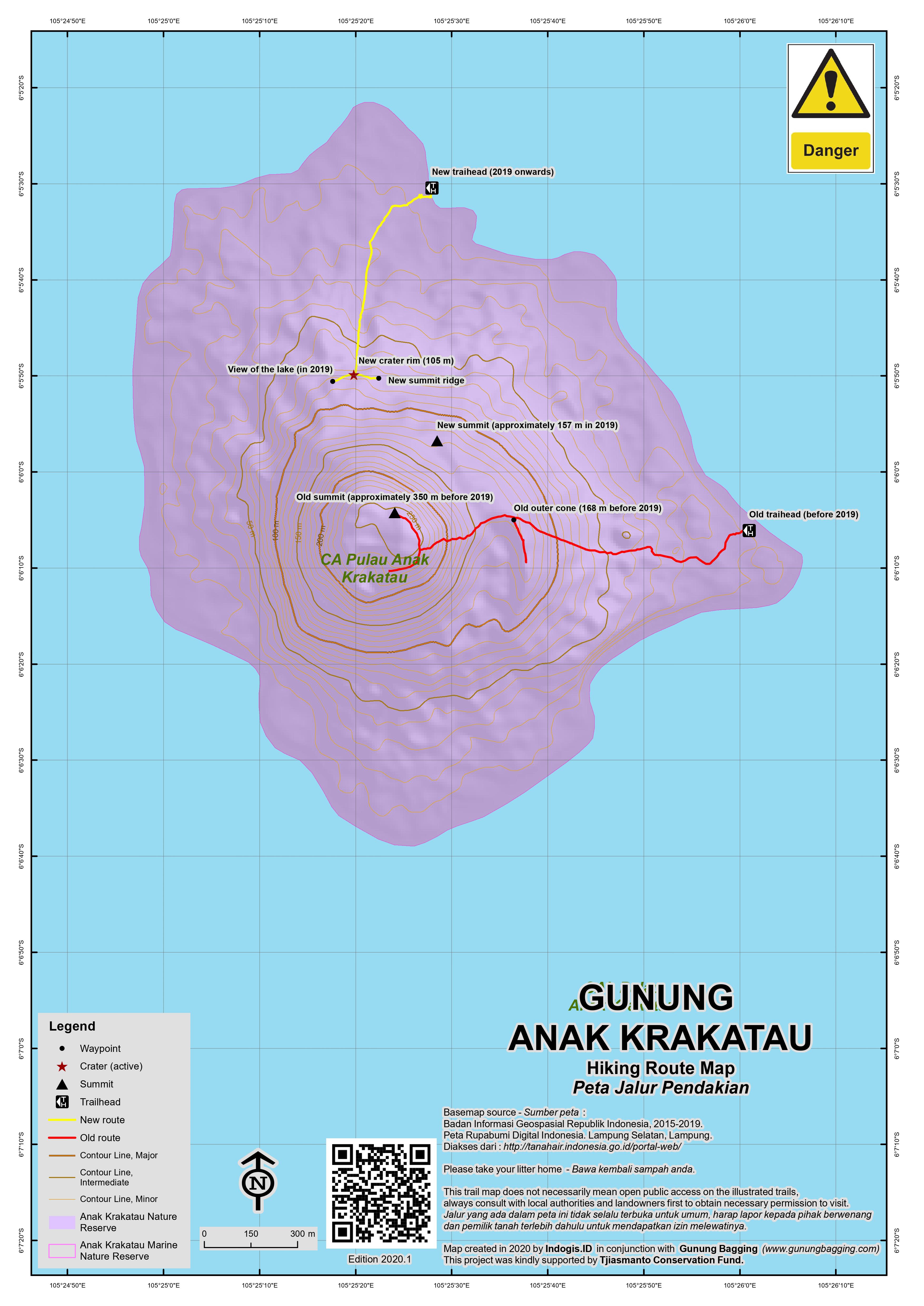
According to estimations by Indonesian authorities in late December 2018, the Anak was now just 110m high, which means it lost over 200 metres in height during the catastrophic collapse (228m to be exact, if their prior figure of 338m was correct). However, based on later readings it appears that the 110m figure may have referred just to the crater rim rather than the highest peak which was in early 2019 measured as being 157m above sea level. Furthermore, in September 2019, scientists revealed that the old summit area of the volcano did not actually collapse into the sea prior to the tsunami (which was caused by a collapse of an estimated 0.1 cubic km – rather smaller than initially thought) but was simply blasted apart during vent migration in subsequent days.
If the volcano follows its previous characteristic behaviour it will continue to grow once more but – assuming an average growth of 5 metres per year – just to reach 338m again will take it over 40 years. To reach Ribu height will require 178 years, but it may require more periods of growth followed by collapse, should the new cone grow steeply once more on the edge of the 1883 caldera. In June 2019, the figure of 157m for the summit height was deemed credible by other local sources.
When access is permitted, there are several organizations offering day-trip tours from the seaside resorts of Carita and Anyer on Java or Kalianda, Sumatra. Although this can be done as a long day-trip, it is much more enjoyable to spend a night camping on a neighbouring island (Rakata or Sertung) especially if the volcano is erupting as you will probably observe the orange glow of lava shooting out of the summit vent at night and hot rocks and pyroclastic flows hurtling down the side!
It is significantly cheaper to hire a boat from the Sumatra/Sebesi side but it takes a lot longer to get there from Jakarta and the vessels tend to be far more primitive. From Carita, it takes about 1 and a half hours by speedboat to reach the group of islands. The usual approach if actually setting foot on the island is to sail between the impressive cliff of Rakata island (on your left) and Anak Krakatau itself (on your right) and then dock on a small sandy beach on the north side of the island.
In June 2019, the island unsurprisingly remains almost entirely treeless, though two small tree saplings (unknown species) appeared to be already growing vigorously on the north coast. None of the information boards and welcome signs remain – Mother Nature has for better or worse reclaimed this zone for herself for the time being. Just a few metres beyond and all you will encounter is dark grey volcanic rock and sand with deep crevices.
Reaching the highest point is quite clearly dangerous even at the quietest of times because the volcano is notoriously unpredictable. It is very common for the volcano to eject large rocks which can easily reach the edge of the island. However, during quiet phases, you might be allowed to climb to near the top.
Prior to the 2018 collapse, it took just under 2 hours to reach the top from the bay at the start of the hike and it apparently now takes around 40 minutes, following a path between crevices from the north coast up to the crater rim (105m) where there is a row of stones for remembering the correct point back down or for navigating in unusually poor weather.
In good weather there are spectacular views over the frequently belching crater lake which is several hundred metres wide and beyond to Rakata. A left turn along the rim leads up to the absolute highest point. Beyond the highest point is another top which is where the Indonesian authorities’ equipment is, including a camera on a tall, difficult-to-access pole which was coated in ash in a late June eruption and at the time of writing still needs to be cleaned.
The following is our pre-2018 report that is obviously now out-of-date:
“Once beyond the trees, the path gets steeper as you climb the black volcanic sands. After 30 minutes you will have reached Anak Krakatau’s outer cone. This is a flat ridge offering fabulous views over to Rakata island and other, smaller islands in the Krakatau group. From here you can also gaze up at the steep, black volcanic cone and watch as sulphur gases rise from the earth. Most hikers are advised not to go beyond this point but during quiet periods it is sometimes possible – though dangerous – to ascend to the spectacular crater rim itself. It’s a tough and exhausting hour of clinging to black sand on the steep cone, zig-zagging across the volcano, trying to find places to dig your feet into in order to not fall all the way back down. There are often also a lot of sulphur gases around which may irritate your lungs. It’s not a good place to sit and ponder the meaning of life because after just a few seconds your feet will start to get very hot as they sink into the earth! If you’re worried, don’t risk it!
For the few that make it to the crater rim, the views are incredible – especially over to the steep cliffs of neighbouring Rakata island, which – at 813m – is the highest remnant of the original Krakatau island. Anak Krakatau crater itself truly looks like the devil’s cauldron! Bubbling mud, thick gases, hideous rockfaces and a narrow, slippery crater rim make this is terrifying yet fascinating place to explore. In May 2011, the highest point was marked with a small cairn, but given the volatile activity of this volcano by the time you read this the top probably looks completely different already.“
You can slide back down to safety very quickly (rather similar to the scree-running that is possible on the cone of Gunung Semeru) and be back on the boat in no time. There are nice places to eat lunch, camp, swim and snorkel on some of the smaller islands in the group – Pulau Sertung to the west offers good views of the volcano at sunrise but Rakata may be safer during times of increased activity. If you’re lucky during the trip, you’ll also encounter plenty of monitor lizards and flying fish.
Anyone visiting Bandar Lampung might wish to visit the simple Monumen Krakatau (Krakatoa Monument) at Taman Dipangga where there is a large metal buoy which was left pretty much where it landed around 1 kilometre inland after the tsunami in 1883.
For a fantastic account of the 1883 eruption, and more information on the Krakatau islands, read Krakatoa: The Day The World Exploded by Simon Winchester.
Bagging information by Daniel Quinn (updated September 2019)
Trail Map
For a high quality PDF version of this and other trail maps, please download from our Trail Maps page.
Local Accommodation
Featured Guides
If you are a reliable local guide and would like to be featured on this page to increase your bookings, or a tourist who would like to support the development of a local guide business, please email danpquinn@gmail.com with the following information: Mountain name, guide name, guide location, guide contact details, and at least one English language review from a previous hiker who was pleased with the guiding services. An example is given below for reference. We have a maximum quota of 3 featured guides for each mountain page on the site. The fee for this is £20 (British pounds sterling, typically via the Wise app or PayPal) for a period of 1 year and helps to pay towards the ongoing development of the Gunung Bagging project.
- Name and location: Pak Budi, Surabaya, East Java.
- Contact details: +62812xxxxxxxx, budi@gmail.com, https://www.instagram.com/budi_mountain_guide/
- Review from previous client: “Budi was a brilliant guide for our September 2023 trek up Gunung X and I would definitely recommend him to other tourists“, John, USA.
Practicalities
- Getting there: From Jakarta, take the toll road towards Merak. You have several options including these two: exit at Cilegon and follow the bumpy road down to Anyer and Carita, or exit at the Pandeglang turn-off and head to the coast at Labuan. Then follow the road north to Carita and Anyer. The former option is easier for navigating but the latter has better quality roads – check with Google Maps or similar for traffic info first. For Kalianda, take a DAMRI bus towards Bandar Lampung and get off at Kalianda town. Then head to Canti pier and take a boat over to Sebesi.
- Guides and GPS Tracks: Want a PDF version for your phone? Looking for a guide? Need GPS tracks and waypoints? Anak Krakatau information pack can be downloaded here.
- Trip planning assistance: Would you like Gunung Bagging to personally help you in arranging your whole trip? Please contact us here.
- Permits: Your boat captain will arrange it (probably in advance).
- Water sources: None except seawater – take sufficient supplies with you.
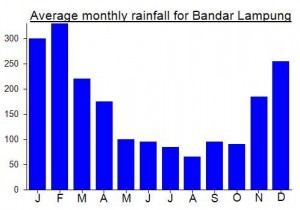
Local Average Monthly Rainfall (mm):
Location
Origins and Meaning
Uncertain. There are four main theories. The first suggests that the name is onomatopoeic, imitating the noise of birds inhabiting the island. The second – most likely – theory is that the name comes from Sanskrit ‘karka’ or ‘karkata’ or ‘karkataka’ meaning ‘lobster’ or ‘crab’. ‘Rakata’ also means ‘crab’ in old Javanese. The third theory is that the name comes from the Malay word ‘kelakatu’ which means ‘white-winged ant’. It is argued that before 1883 Krakatau slightly resembled an ant seen from above. The fourth – and least likely – theory is based on a linguistic error when a ship’s captain asked a local man for the name of the island. The local man replied ‘Aku nggak tahu’ which means ‘I don’t know’ in Indonesian/Betawinese. (Wikipedia, 2011).
Given the likelihood that Krakatau had been the site of a vast number of violent eruptions dating back many centuries, perhaps the onomatopoeic theory actually be strengthened by the idea that the name imitates the sound of volcanic eruptions.
‘Anak Krakatau’ meaning ‘child of Krakatau’ is the name given to the new volcano which emerged in 1927.
Links and References
Wikipedia English
Wikipedia Indonesia
Wikipedia. 2011. Krakatoa. Accessed from http://en.wikipedia.org/wiki/Krakatoa
Some serious activity yesterday or the day before at Anak Krakatau! https://en.antaranews.com/news/213553/mount-anak-krakatau-erupts-nine-times-in-one-day
Fantastic article on the BBC today about the eruption, collapse and tsunami in December 2018.
https://www.bbc.com/news/science-environment-50798253
“Shattered remnants from the volcano that generated a devastating tsunami in Indonesia a year ago have been pictured on the seafloor for the first time.
Scientists used sonar equipment to image the giant chunks of rock that slid into the ocean when one side of Anak Krakatau collapsed.
Some of these blocks are 70-90m high.”
Interesting piece on the BBC this week about the actual collapse that caused the tsunami and how it seems to have been smaller than originally thought, with further collapses (including of the old summit area) in subsequent days due to vent migration.
“These changes refer to the removal of the summit. The cone and crater are still visible and intact in the Sentinel image. They only disappear in subsequent days.
Dr Williams’ team now think the flank collapse may have reorganised the plumbing of the volcano, opening a new vent that brought magma directly into contact with seawater. This would have initiated violent phreatomagmatic activity which is evident in the spectacular photos taken from an aeroplane that flew around Anak Krakatau in late December.
“The behaviour seen in those pictures was very typical of these marine explosions and it’s this violence that removed the summit,” she explained.
“Over the following weeks, as the volcano started to build again, the water was eventually stopped from getting into the magmatic system and Anak Krakatau went ‘back to normal’. ”
https://www.bbc.com/news/science-environment-49568107
The first I heard about the Sunda Strait tsunami on Saturday December 22nd 2018 was a Tweet from Oystein Lund Andersen with a photo of cars in deep water and a mention of a ‘weird wave’. He had had to run for higher ground with his family. I was on the south coast just metres from the ocean at Pantai Sayang Heulang south of Garut, West Java, so I immediately searched for information on earthquakes as there was the potential that this could affect this area too. There was nothing. No earthquake reports. Very odd. I guessed it must be something to do with Krakatau.
Just hours before I had been complaining about being stuck in horrendous traffic near Cikarang on what turned out to be a 9-hour bus journey to Garut. I had to stand all the way! Oystein had replied that I should have come in the opposite direction to the Anyer/Carita coast as traffic in that direction was clear – no jams. I said that I had been to that area enough times and fancied trying a new place. Shortly after, Oystein posted some great images of Rakata and Krakatau taken from the coast where he was in Anyer and wrote ‘boy this is going to be a long night’. How right he turned out to be, sadly.
At first authorities suggested it was a ‘tidal wave’ caused by high tide and full moon, but reports slowly trickled out that people had lost their lives to this, including a local rock band called Seventeen whose stage had been swept away from under them as they played at Tanjung Lesung. This was captured on video now famous but also horrific. By this time the authorities had changed their story and apologized. This was a major incident – and a week later the death toll is over 400 and could rise still further.
Having been camping at Rakata just the month before on a Saturday night similar to this one, it was very sobering indeed to hear of what happened. Krakatau had collapsed catastrophically, and within one minute a wave of 15-30m height had smashed Rakata and neighbouring islands – nobody there would have survived, but thankfully there are no reports of anyone having been there that night. Within about 30 minutes, the tsunami hit the mainlands of Java and Sumatra. People were totally unaware as no alert had been given and it was dark so impossible to see from afar.
Out trusty guide for Krakatau, Samsul Hidayat in Carita, was thankfully unharmed, having slept through it all and only become aware the following morning when he was woken by neighbours. You can read his comments here https://www.aljazeera.com/news/asia-pacific/2018/12/indonesian-tsunami-impossible-predict-experts-181223103309361.html
A week later it was revealed using satellite imagery that Anak Krakatau was now only 110m high, meaning it lost well over 200m in height when it collapsed. Two-thirds of its volume. A couple of days earlier, someone had found a scientific paper detailing the risk of such a thing happening, as the cone was built in such a steep, volatile fashion that it was a definite possibility. Clearly this possibility became a reality, in quite horrendous style. The Anak is now doing Surtseyan eruptions, where magma mixes with water and a 5km exclusion zone is in place. Would be fascinating to watch as it has totally reconfigured itself, although I wouldn’t be surprised if the exclusion zone remains in place for a long time – quite sensible.
What will the future hold? A cycle of growth and collapse or will it somehow build a stronger structure next time that is less liable to collapse? Who knows….
This is the biggest Krakatau-related event since 1883, but this will be of little reassurance to those living near the volcano. It could and probably will happen again at some point a few decades from now.
You can read Oystein’s excellent eyewitness account on his website here: http://www.oysteinlundandersen.com/krakatau-volcano-witnessing-the-eruption-tsunami-22december2018/
Had an absolutely brilliant weekend watching the Anak Krakatau eruptions from our camp area on the beach on neighbouring Rakata. Headed down after work on Friday, arrived at Carita by about 9pm. Had originally thought about getting the commuterline (train) all the way to Rangkasbitung and then hiring a car/driver/taxi to get from there to Carita (2 hours) but we didn’t need to do this in the end.
Stayed at Sunset View as usual as it a reasonable price, is very close to the pier (Lippo Marina) and has a bizarre framed map of the islands with ‘potential for popping’ written across it. Had Samsul as guide as usual. If you have 6 or 7 in your party then you can charter him and his boat and crew (08129611218). Good food provided as always.
We had cloudy and rainy weather most of the weekend, but if anything this made conditions even more atmospheric, with the Anak erupting pretty much every 20 minutes or so. Very impressive to watch from the beach below the steep cliffs of Rakata, with old gnarled tree trunks and stumps in the foreground. There were a handful of other boats and campers for Saturday night, but more than enough room for all. Saw some monitor lizards either fighting, dancing or mating near camp!
After dark, we could see orange spurting out of the summit vent, and huge orange rocks hurtling down the slopes of the cone. This is difficult to get on normal cameras so consider bringing something special with you or at least getting your night settings ready before you have had half a dozen beers.
This was my 4th time to the islands and it never gets dull. Probably the best weekend trip you can do from Jakarta without getting on an aeroplane.
Hi Dan,
How much is the boat cost from Carita to Rakata Island?
Hi, I just went to Krakatau and could only climb to the viewpoint around 150masl. The park ranger didnt let anyone go beyond that point and the reason given was that the soil was too hot to walk on.
Visited Anak Krakatau again at the end of last month. Unusually fine weather for the time of year. The Anak was not belching, but there was a vast quantity of white gas being expelled making it impossible to climb any further than to the outer cone. Some great view of Sebesi and the mainland Lampung peaks in the distance. Quite a number of impact craters on the way up created by rocks hurled down the mountainside in recent weeks. Take extra care on this one at present and remember to cover your nose and mouth if you do bother to climb up to the outer cone.
Back in Carita I was sold some red bananas. Having never tried them I simply had to give them a go. Taste not too dissimilar to the regular yellow ones but slightly less sweet. Apparently locals don’t eat them, regarding them as being inferior. No wonder the old woman have me the entire bag full for Rp20,000.
Just back from a weekend to bag both Anak Krakatau and Rakata. We camped on the lovely Pulau Sertung on Saturday night, looking directly at Anak Krakatau and Rakata which from this perspective look approximately the same height! One member of our group was swimming in the sea at 6am when what he thought was a small piece of wood stuck its tongue out at him!!! These islands are simply full of monitor lizards (biawak). There were also signs that a turtle or two had been onto the beach to lay eggs not far from hwere we were camping.
We had been told that after a few weeks of relative quiet, the Anak had started getting a little active again although despite seeing a lot of white gas being ejected from the crater we didn’t hear any noise or see anything major going on.
So, we decided to give it a try. Once at the outer cone I would have been happy enough just to take pictures of Rakata island and leave the true summit for another, quieter day. However, others in the group pushed on so after lots of slipping around on what seems like near-vertical hot, black volcanic scree we all managed to make it to the spectacular crater rim. There was a lot of gas around so I we didn’t stay long at the summit, but long enough to get some great photos. My GPS gave a reading of 324m, which sounds about right given that the beast is growing by 5 metres a year.
When we reached the outer cone on the way down a National Park warden had his arms very much folded in a disapproving manner. Apparently we shouldn’t have climbed it. It is a risky business but so is crossing the road.
Afterwards we headed over to a beach on Pulau Krakatau Kecil for a quick swim before returning to the Java coast.
Went to an excellent Go Wild talk last night at Hotel Kristal, South Jakarta. The speaker, Mike Dobie, gave a brilliant talk on the history of volcanoes in Indonesia. One of the most interesting things he mentioned was the theory that there was an enormous eruption in the Krakatau area in approximately the year 535 which created the Sunda Strait (i.e ripped Sumatra and Java apart into two separate islands). There’s a book about it called Catastrophe by David Keys. The truth of it is obviously incredibly hard to verify but it’s probably worth a read.
Have a look at:
http://en.wikipedia.org/wiki/David_Keys_(author)
http://www.amazon.com/Catastrophe-Investigation-Origins-Modern-Civilization/dp/0345408764
http://en.wikipedia.org/wiki/Extreme_weather_events_of_535%E2%80%93536
Hello,
I have just came back from Krakatua this Sunday. Some Indonesian friends of mine arranged the trip via from a port in Lampung (Pelabuahan Canti). We rented a APV in Jakarta and took the ferry from Merak to Sumatra. We had arranged a boat from the islanders of Pulau Sebesi who live within 2 hours of the volcano. We left the port in Sumatra around 8 am adnd dropped our bags off in a little room which was arranged for us on Pulau Sebesi. We then jounied onward to Anak Krakatau which took another gut busting two hours, The seas were rough and I thought our boat was going to fly apart. We were treated to numerous large eruptions and did some island hopping.When our boat went back by Anak Krakatau were greeted with more eruptions. The local park service was apprehensive about letting us get on the island as I am sure you can underdstand. Krakatau is truly another world unto itself and should be treated with great respect.especially those rough seas. thanks Zac
Krakatau’s crater has ‘expanded’…..
http://www.thejakartaglobe.com/home/krakataus-crater-expands-eruption-frequency-increases/405688
Hey all,
Thanks for the info, very precious to arrange a good trip.
Terima kasih banyak
I’ve been out there half a dozen times with the guys from the Marina at the Mambruk Hotel in Anyer. They have a good fast boat, and the trip takes around 45 minutes. If you want to organize the trip in advance, just call the Mambruk, and ask them to transfer you to the Marina. Cost is around Rp 2 million for the whole day, and the boat seats six people.
The three top things to do when there would be (i) climb Anak Krakatau (unless it’s too dangerous to do so); (ii) do a circumnavigation of Anak Krakatau by boat; (iii) visit Pulau Sebuku on the way back to Anyer.
Hi Henny,
I visited Anak Krakatau in Jan 2009. I prearranged a pick up from Jakarta and an one-day boat trip to the volcano with Java Rhino ( http://www.krakatautour.com/index.htm ). The owner is Ian Sebastian, nice guy.
The pick up cost Rp.900,000 while the one-day tour package cost Rp.3,500,000. Guide, life jackets, snorkelling equipments, food and drinks are provided for the tour. If you wander around Carita beach for those touts, you can get an one-day tour for around Rp.2,000,000, however, there’s no guarantee of boat quality, and no extra services except for taking you to the volcano.
I stayed at Sunset View Hotel. A very basic hotel but convenient location. If you’re to stay there, make sure you drop by the fish market of Labuan town to buy some fresh seafood, and get the hotel receptionists make some BBQ out of it. VERY tasty!
Hope this helps.
Jia Hao
I went last year on what was an expensive trip compared to what you could get on the day in Carita. With 3 others and including transport to/from Jakarta it was less than a million each. A car should be no more than about 600,000 for the day.
As for getting a boat, if you’re Indonesian you’d get a much better price than us foreigners!
I’ve also seen local group tours that go to Krakatau and Sebesi island – and include 2 nights accommodation, transport, meals etc – for less than a million in total for the whole weekend. For example, this local organization http://daladventure.blogspot.com/ (but they don’t have a trip scheduled at present)
Hey there,
My friend and I plan to go to Krakatau on 3-5 November 2010. I was looking for a schedule trip but there was non available. So I decided to arrange the trip myself.
As you have been there, do you still have the contact person for the boat to reach the island? Can you tell me how much was it, daily or per trip? Please tell me the detail of your trip to Krakatau? Do you know any guide to assist us in climbing the mountain?
I would highly appreciate if you could write me in detail.
Thank you
Henny
I know it may seem strange, but if you do travel to Cerita you will have no problem finding a local boat that is keen to take you to Krakatau. It’s not so easy to arrange in advance, but usually your guesthouse or hotel can do that for you. Make sure you get a good boat because it is quite a long trip to the Krakatau islands. You will have no problem when you arrive as anak Krakatau is very small – you arrive on the small beach and hike up one of the ash slopes. Note that it is currently too dangerous to go to the summit! A nice diversion afterwards is to do a bit of snorkling around the edge of one the remnants of the old Krakatau. Your boat will surely know this.. Good luck – go for it – it’s a fantastic trip once you escape the industrial suburbs of Jakarta.
Great info but about what should the fee be for the boat trip?
Hi Henny
How did your trip to krakatau go in November last year?
regards
Tariq
Hi Henny
I don’t have a number for the contact person but I don’t think it should be too difficult to arrange in Carita (or Kalianda, Lampung). You should be able to find some phone numbers if you do a Google search.
Good luck with the weather…