
Facts
- Elevation: 1,285 m (4,216 ft)
- Prominence: 1,052 m
- Ribu category:
 Kurang Tinggi
 - Province:
 Kalimantan Selatan (South Kalimantan)
 - Coordinates: -3.6904, 115.0307
- Rating:

 (3 votes) Add your rating
 Loading...
 - World Ribus ID: 69194
Photos


Bagging It!
The southernmost Ribu on the island of Borneo, Gunung Kahung is the highest of a cluster of peaks at the southern end of the Meratus mountains. It lies on the south-eastern side of the large Waduk Riam Kanan (Riam Kanan Reservoir) beyond the friendly tourism village of Belangian. The whole area is very scenic and is slowly becoming more and more popular with hikers both from the nearby city of Banjarmasin and from further afield.
Despite its low height, Gunung Kahung used to be a really time-consuming mountain to reach the top of. Back in 2010, before there was a clear trail, a hiking group took 12 days to reach the top! However, since a ‘Merah Putih expedition’ for annual independence celebrations in August 2018 it can be completed in three days, including getting to and from the starting point, and even from and to Jakarta for the very fit and efficient.
The suggested itinerary is as follows:
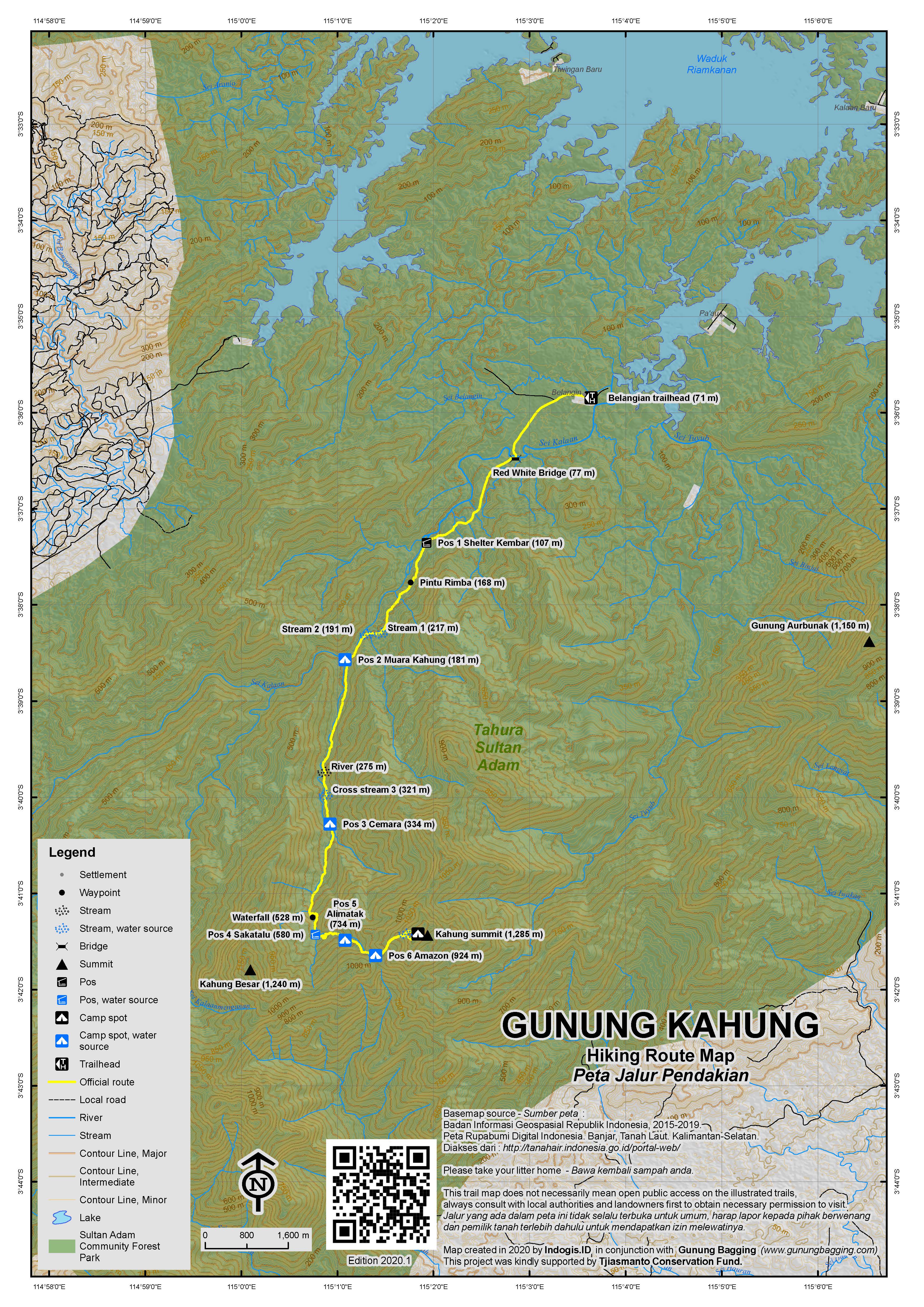
Day 1. To half-way up the mountain (Pos 3/4/5).
Banjarmasin Airport – 30 min – Banjarbaru – 40min – Tiwingan – 90min by boat – Belangian – 20min ojek/90min walk – Pos 1 – 1 hour – Pos 2 – 90min – Pos 3 – 2 hours – Pos 4 (total 7.5 hours or 8.5 hours without ojek plus 1.5-2 hours for breaks and admin = 10 hours total from Airport to suggested camp).
If you haven’t stayed the previous night in Banjarbaru (strongly recommended) or Banjarmasin, then make sure you take the first flight from Jakarta (or elsewhere) so that you are in the area as early as possible. From Banjarmasin Airport it is about 25 minutes by car or motorbike to the centre of Banjarbaru and a further 40 minutes from Banjarbaru to the small town of Tiwingan on the shores of Waduk Riam Kanan (65m).
There are numerous boats at the reservoir which can be chartered for a reasonable price although you may need to negotiate and be sure to arrange a pick-up time for your return journey after the hike as the mobile phone signal near the mountain is currently very patchy (aside from on the summit itself!) Typical boats here can easily accommodate 25 hikers and they take around 90 minutes to cross from Tiwingan to Belangian. In November 2018 the price for a return journey was Rp1,000,000 in total (Rp500,000 each way). Note that you are unlikely to be able to make the crossing in the dark as captains are very reluctant since a couple of recent accidents.
In good weather the journey across the reservoir is very scenic indeed. Only a couple of kilometres from Tiwingan is Pulau Pinus, a small island with pine tree woodland on it which is connected to the mainland by a bridge. Beyond this point, the wide open expanse of water offers great views of numerous small mountains in the area. The sloping triangular peak that is clearly seen to the southeast is Gunung Aurbunak (1,150m) which is apparently a decent hike in itself – requiring about 3 days in total from the starting point at the village of Pa’au which is seen on the way to Belangian.
To the south lie Gunung Kahung (1,285m) and Kahung Besar (‘big Kahung’, approximately 1,240m), more mysterious mountains consisting of numerous tops that are less easy to see from the reservoir. Kahung itself is the further east of the two main peaks and is known to some local people as Kahung Kecil, not in relation to its size (which is obviously slightly greater than the lower Kahung Besar) but because of the names of rivers and waterfalls on its slopes. A third peak further west of Kahung Besar has been given the beautiful name ‘Gunung Panggilangin’ (‘the mountain that calls the wind’) and is slightly lower still at 1,100m plus.
At the end of the dry season (October-November), the last section of the journey across the reservoir is a little tricky as the water level is very low, so be prepared for some minor delays if the vessel gets temporarily stuck in the rich, orange mud! It’s a lovely area for photographs, with eagles often seen perching on one of the many dead tree trunks and stumps near the water’s edge.
Finally you will arrive at the entrance signs for the small village of Belangian (71m) and Sultan Adam Forest Park. Follow the main track for 300 metres into the village and register at the warung on the left where there are a couple of signs including a map of the trail to the summit that was made by Mapala Piranha at the time of the August 2018 expedition. You can buy simple snacks here at the warung but ideally you should have brought all your important items from Banjarbaru.
From Belangian, the trail to Lembah Kahung (Kahung valley) follows a cement track (take a left at the first fork) for several kilometres before entering forest, so it makes sense to take ojeks to save over an hour of walking in direct sunlight at very low elevation. Expect to pay around Rp40,000 one-way for the 15-20 minute ride, which is especially pleasant at the large red and white bridge over the river. You will probably be taken about as far as Pos 1 (Shelter Kembar – ‘the twin shelters’, 107m) where there are two large wooden shelters at the side of the river.
In 2018, a track is being constructed beyond Pos 1 as far as the forest entrance (168m), so access is likely to become even easier. This area remains one of the few in this region where illegal logging has not yet occurred, so let’s hope that it becomes a regular hiking route and that the loggers are kept away. Do watch out for mosquitoes as there are quite a few in this valley so repellent is advisable. Finding water on the trail to Kahung is no problem at all – with reliable sources at or near all Pos plus 30 minutes below the summit. There are many, many stream crossings and you will probably get your feet wet at some stage.
Once in the forest, it takes around one hour of mostly flat walking near the side of the river with a few small stream crossings before you reach the lovely Pos 2 – Muara Kahung, which is where the Kahung river meets the larger Sungai Kala’an. Here there is another decent-sized shelter which would be ideal for a small group of 6 or less assuming no rain (in 2018 the roof is under slow repair). It may only be 181m above sea level, but at night this spot is pleasantly chilly and you may appreciate an extra layer or even a sleeping bag!
If you are to complete the Kahung trek in 3 days, ideally you want to be higher up the mountain than Pos 2 by the end of Day 1. From Pos 2 to to Pos 3 (‘Cemara’, 334m) takes 90 minutes to 2 hours and sadly the forest here is rather degraded, not by loggers but by a forest fire that happened in 2015. Pos 3 has another shelter and is next to the river, but the shelter is in need of more serious repair than the one at Pos 2.
For a trek that is only just becoming known more widely, you might think that it is quite remarkable that these shelters exist at all. It appears that they were constructed some years ago to encourage tourists to visit the waterfall which is a little further along the trail.
Beyond Pos 3, the trail gets steeper and in wet conditions can be very slippery. Luckily there are a few basic ropes to hold onto but with big bags it is quite challenging. After an hour or so is a small junction on the right to the pleasant waterfall (528m). This waterfall is definitely worth a quick 10 minute detour, but the path is pretty hazardous with considerable drops on the right side. Back on the main path and the trail itself becomes much steeper and tougher, and it is obvious that whereas the trail as far as the waterfall has been well trodden by hikers over the years, the section beyond is much wilder!
After the steep ascent from the waterfall area, the trail descends to a lovely meeting point of 3 separate rivers. It takes around 40 minutes to reach here. This is Pos 4 (‘Sakatalu’, 580m) but there is no obvious camping spot here at all. Another 20 minutes beyond the river crossing is slightly flatter terrain (620m). It is not ideal, but for those wishing to complete the hike in 3 days it may be the best choice to make a wild camp on relatively flat ground to the right of the path. Obviously you could stay back at Pos 3, but then your second day of hiking will be a very long, tough one. Or you could continue to Pos 5 or Pos 6 but Pos 5 is the worst spot for leeches and why carry camping equipment all the way to Pos 6 if you don’t really need to? It obviously depends on the weather and on the energy of your group too.
Day 2. Half-way up the mountain – summit – back down to Pos 3 or Pos 2.
Assuming you camped somewhere around Pos 4, it is recommended that you leave camp at about 4am on the second day with torches or headlamps so that you can be up at the peak not long after first light and have sufficient time to return all the way down to Pos 3 or Pos 2. For those who are fit and not carrying tents and camping equipment with them it takes about 3 or 3 and a half hours to reach the summit via Pos 5 (‘Alimatak’, 734m) and Pos 6 (‘Amazon’/’Amajon’, 924m) (both of which are better spots for camping than Pos 4 but have the disadvantage of having more leeches and being further up the trail!)
Beyond Pos 6, the vegetation starts to change into mossy forest, despite the low elevation, and above 1,110m you will find some lovely pitcher plants (Nepenthes boschiana, according to Alastair Robinson). It is also around 1,100m where you first get panoramic views over to Kahung Besar and back down to the valley. Progress is slow, as you have to clamber over gnarled dwarf tree trunks and watch out for holes beneath your feet. At 1,145m there is an obvious rest spot with views.
At a minor junction (1,150m) which is the start of a small summit loop trail, it is best to stay to the right for the best views (or head 50 metres to the left for the final source of water (1,170m) before the peak) and continue battling with the tough but beautiful terrain along the narrow summit ridge before you finally reach a very small clearing with numerous signs and posts, most of which were constructed recently in August 2018 when 300 or more local hikers made an attempt to reach the summit!
US Army Maps from 1954 give a height of 1280m for the top of Kahung and call the range itself Pegunungan Kusan. My GPS gave readings of around 1289-1293m but settled on around 1289m. We are therefore using 1,285m as it seems reasonably conservative based on the information available. Ignore the summit signs suggesting the peak is as high at 1,456m! This figure is taken from the Bakosurtanal map but is way, way off!
There is a little bit of space to camp here at the summit and enjoy the sunset and sunrise views should you so wish. The second-highest peak in the range (Kahung Besar) is clearly visible in good weather just 3km to the west and is occasionally climbed but requires around 4 days to complete as the trail is rarely-used and perhaps even overgrown if nobody has been there in recent months. It follows the Kahung trail as above as far as Pos 3 where you take a turning into denser forest. There are no water sources beyond the regular Kahung trail. There have been a few videos posted on Youtube from local hiking clubs – one with a GPS showing a height of over 1300m at the peak but based on our research this reading is likely to be an exaggeration or error.
Depending on how you late you started and where you started from, the objective should be to return to camp and then head down to Pos 3 or Pos 2. It took us under 6 hours in total to get down to Pos 2 from the summit but assume 6 hours for Pos 3 and 7 hours for Pos 2 to be on the safe side, meaning descending from the peak no later than 11am if you want to reach your destination before dark.
From the summit, you can continue on beyond the signs and rejoin the main trail at the junction after the final water source, assuming you did the summit loop in an anti-clockwise fashion (i.e stayed to the right at the water source junction just below the summit). Either way, there is only one trail back down once you rejoin it.
Day 3. Pos 3 or Pos 2 – Belangian – Tiwingan – Banjarmasin Airport.
If you need to make it back to Jakarta on the third day, then be sure to book the last flight (typically around 8pm) so that you have sufficient time to allow for any problems or delays. A reasonable plan would be to leave Pos 3 no later than 7am or Pos 2 no later than 8am to be on the safe side and have a boatman waiting for you at Belangian for an 11am departure back to Tiwingan and Banjarbaru.
If you have extra time on the way home, you might want to either walk or take an ojek (Rp50,000 one-way) from Tiwingan up to the top of Bukit Matang Kaladan. This 200m-high hill has some good views over the reservoir and towards Gunung Aurbunak but Kahung itself is obscured.
Bagging information by Dan Quinn (November 2018)
Trail Map
For a high quality PDF version of this and other trail maps, please download from our Trail Maps page.
Practicalities
- Getting there: Banjarmasin is the nearest airport – about one hour from the reservoir.
- Guides and GPS Tracks: Want a PDF version for your phone? Looking for a guide? Need GPS tracks and waypoints? Gunung Kahung information pack can be downloaded here.
- Trip planning assistance: Would you like Gunung Bagging to personally help you in arranging your whole trip? Please contact us here.
- Permits: At present (November 2018) the entry ticket to Kahung Valley costs just Rp2,000 per person. Register at the warung in Belangian and take a photocopy of your KTP or passport photo page just incase. A great local guide is Bang Hekmi: +6285248474193.
- Water sources: Numerous throughout the trek -at all Pos and also 30 min before the summit. Therefore only one large water bottle required per hiker. Anyone attempting the more obscure Kahung Besar (the second highest peak) will need to take plenty of water with them from Pos 3 on the normal trail as there are no more reliable water sources on the Kahung Besar route.
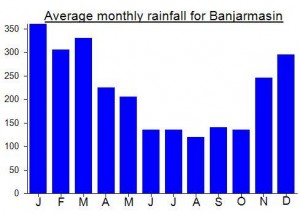
Local Average Monthly Rainfall (mm):
Location
Click on the blue arrow ![]() (top right) to see your current location on the map
(top right) to see your current location on the map
When I first researched Gunung Kahung, nearly ten years ago, I could only find one person who had hiked it, and his team had taken 12 days! Excessive noodle breaks or not, that is a lot of time for such a small mountain. This was long before there was a proper trail, and it is only this year that it has become accessible enough that you can climb it over a long weekend.
I met Bang Hekmi (+6285248474193) at Banjarmasin airport, and immediately knew he would be a good guide – perhaps one of the best I have encountered, and with a real enthusiasm and knowledge of the area (he’s from Belangian originally). With it being too late to get a boat over the reservoir I stayed a night in Banjarbaru…. At Kost D’Oen. Rp200,000 and very friendly indeed.
The next morning we set off for Tiwingan and almost immediately got on a boat over to Belangian. A gorgeous morning…. Very clear and ideal for photographs. Belangian itself has enormous potential… I can easily see it becoming more and more popular over the next few years but for now there are no losmen or hotels – it’s just a simple farming village for now. And there are no expensive rituals or anything like you find in other parts of Kalimantan. You arrive, have a coffee, register, and get hiking. How it should be!
It was very surprising to see a terrain and route map to Kahung summit which is outside the warung where you register and was apparently erected by Mapala Piranha in August 2018 when the massive expedition of 300 or more hikers headed off to the summit. Whilst I don’t enjoy hiking with so many folk, it certainly meant that the trail was still clear all the way to the top.
However, I was a little concerned as there are two peaks of a fairly similar height. Kahung and Kahung Besar. But based on SRTM and this terrain map it was clear that thankfully the expedition in August had been to the top of Kahung (the highest one) rather than Kahung Besar which is a few metres lower and much more overgrown and difficult to find water on. But the map and signs suggesting the peak is 1456m…. no chance…. 1285m is my estimate based on GPS and other factors.
With it being a long weekend, there was a student hiking group already ahead of us, having set out the evening before. 37 of them! Quite unexpected for such an obscure mountain, but it appears that in 2018 Kahung is starting to get popular. As long as the forestry department don’t try and close the trail I think this could become nearly as popular as Gunung Besar (Halau Halau) which is the highest in the province and sees numerous hiking groups every month.
We made it as far as Pos 4 and a bit and made a wild camp on a flat area a few metres from the trail. This being Indonesia, we were not left alone for long and some of the 37 decided to camp next to us, rather than struggling on in the dark to Pos Amazon. One poor girl had a seizure but thankfully was fine – perhaps brought on by excessive tiredness.
We decided to set off the next morning by 4am and this proved to be a good move as we had some excellent views at the top, over to Kahung Besar and on the other side to a lower peak on the ridge beyond Kahung called something like ‘Saraung ooh-ooh’ because birds that make an ‘ooh ooh’ call live on it! As we descended, using the alternate section of the summit loop trail to visit the little stream, the 37 made their ascent, but most of them got no views as it started raining by mid-morning.
We made it to our destination of Pos 2 by about 2pm. Obviously we could have made it all the way back to Belangian but why bother when there are no hotels yet anyway? In any case, I had some serious humidity-related chafing in my nether regions which meant I was very glad to have an extended break. Curiously for a place of such low elevation, Pos 2 got a little chilly later in the evening and I was glad of my sleeping bag. Some of the 37 stayed with us at Pos 2 and one guy was telling me about a rocky cliff peak in Central Kalimantan called Bukit Kubau which can be done as a day trip from the nearest village. Photos looked quite impressive.
The next morning, we got up leisurely and made our way back to Belangian. Only took 2 and a half hours and in an emergency you could probably get an ojek back from Pos 1. Pos 1 looks like a great spot to spend the night too, but apparently the water in the river is muddy and also there are workmen building the new track who are staying there at the time of writing. On the way into Belangin are banana, rubber and petai plantations. Bang Hekmi told me that there are sun bears, mouse deer, wild pigs, wild chickens and wild cats in the forests in and around Kahung. This is a great spot for birdlife too, but I was too slow to get many photos except of an eagle on the way back over the reservoir, perched on a tree stump.
‘Kahung’ the word apparently comes from ‘ga hung’ in the local language meaning something like ‘the inner forest’. Let’s hope it stays that way – a lovely trek, if I had an amendment to make to the top 10 list of Borneo hikes I would probably put this is in at the start as a bonus number 11.