
Facts
- Elevation: 1,628 m (5,341 ft)
- Prominence: 1,514 m
- Ribu category:
 Kurang Tinggi
 - Province:
 Nusa Tenggara Barat
 - Island: Sumbawa
- Coordinates: -8.3939, 118.5424
- Rating:


 (5 votes) Add your rating
 Loading...
 - Other names: Ndindi, Oromboha, Lambuwu
- World Ribus ID: 69081
Photos


Bagging It!
Doro Dindi (previously mistakenly-known as Doro Oromboha) is located to the west of the town of Bima, about 25 kilometres in a straight line (or just an hour on motorbike). The trailhead is at the hill village of Padende (795m) in the Donggo region. Unlike the roasting hot and often bone-dry treeless lowlands of Sumbawa, this highland area is forested and is apparently excellent for farming.
Quite surprisingly for the island of Sumbawa, there is a small Christian population in this area and the region is also known for its pre-Islamic animist belief system and traditions. Also of interest is an inscribed stone (‘batu tulis’) called Wadu Tunti Bumi Pajo just a kilometre or so down a bumpy track from Padende. This supposedly dates from the 14th century and features sanskrit text and images. Possibly related stones carvings known as Wadu Pa’a are to be found about 60 kilometres from Bima on the coastline.
Very few hikers climb into the forests of Doro Dindi, usually preferring to ascend the steep, bald pyramid hill called Doro Leme (1,140m according to one old military map) – which is clearly visible from the trailhead – and from the summit of which you can apparently clearly see Sangeang island. However, Doro Dindi can easily be hiked in a day, requiring only around 3 hours up and a similar amount of time for the descent.
Doro Dindi is at the present time actually only frequented by occasional local villagers collecting wood with which to build houses or to hunt. The trail is very clear to begin with and leads gently up through farmland, scrub and follows two water pipes before reaching a river (965m) in less than an hour. Just before arriving at the river you will be able to see the sharp peak of Doro Dindi ahead on the left. The trail disintegrates at the river into a couple of vague paths but if you cross over the river and head up the hillside to the left of the river you will soon gain a ridge (1,030m).
The trail at the middle section is rather vague in certain spots but then very clear on the narrower sections of ridge with mossy rocks. After a further hour you will reach another ridge (1,455m) where to continue going up you need to turn right. There are pandan plants and quite a few thorny vines to watch out for here. It is clear that wild pigs (‘babi hutan’) live in this part of the forest as you will see where they have been digging.
In clear views there are some decent views to be had, but often by lunchtime it is already hazy or even cloudy. In about another hour (or 3 in total) you should have reach the true peak, which in 2018 was unmarked except for evidence of a small fire presumably made by a local villager to keep warm. There are no signs and only limited views through the trees, which is a shame as from here it ought to be possible in excellent conditions to glimpse the mighty Tambora volcano about 70km to the north-west.
However, although it may not feel like it, Doro Dindi is a pretty significant peak. At around 1,618m (according to an old military map), Doro Dindi probably has over 1,500 metres of prominence and is therefore likely to be not just a Ribu but an Ultra (ultra-prominent peak). The Bakosurtanal map lists this peak as Doro Lambuwu with a height of 1,628m.
There is a lot of confusion as to the different names of the peaks in this range. Old military maps show Lambuwu and Denden (the latter perhaps from the village name ‘PaDENDE’) but according to locals that we interviewed on two separate occasions, the name of this highest peak is definitely Dindi (or possibly ‘Ndindi’). Those same local people use Oromboha (apparently meaning central or ‘middle peak’) to refer to the pyramid hill Doro Leme (it has several names, perhaps due to its memorable shape). ‘Dindi’ apparently means ‘closed’ in the local language and perhaps refers to the fact that it is a difficult mountain to see, being hidden or closed from view.
From aircraft into and out of Bima airport, Doro Dindi is clearly visible, along with Doro Leme. It is interesting to see that Dindi has two tops of a similar height less than one kilometre apart but this south-eastern one is definitely a little higher than the north-western one which, according to the Bakosurtanal map, is 1,601m in elevation.
The Smithsonian Global Volcanism Program refers to the range as Lambuwu or Lambuwa, which it describes as a Quaternary volcanic zone and is not thought to have erupted for at least tens of thousands of years. Certainly there is nothing to suggest to hikers of this peak that there is any ongoing volcanic activity.
You can be back down at the village of Padende in under three hours.
Bagging information provided by Daniel Quinn (July 2013, updated October 2018)
Trail Map
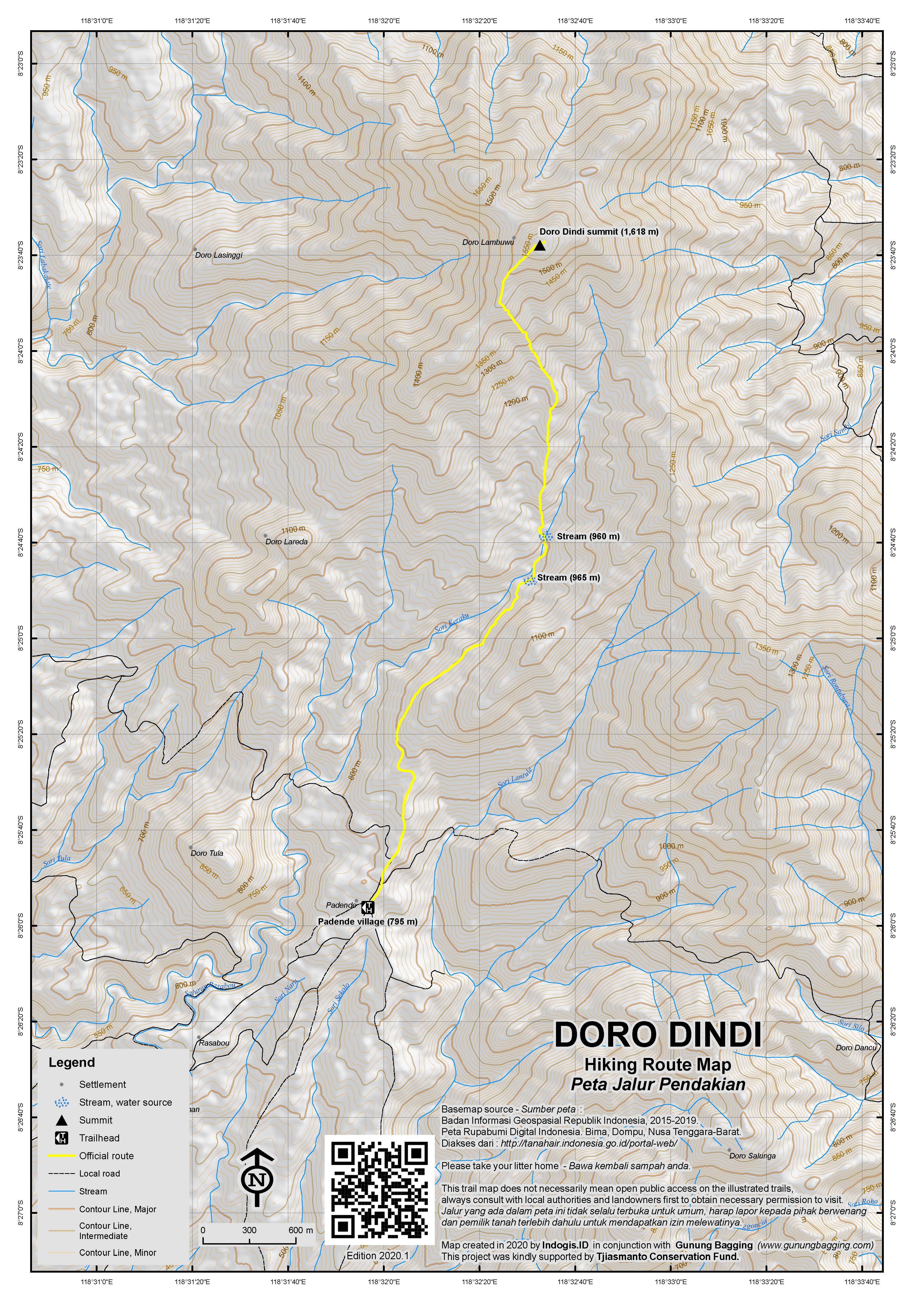
For a high quality PDF version of this and other trail maps, please download from our Trail Maps page.
Practicalities
- Getting there: Several flights per day to Bima from Denpasar. It takes just one hour to reach the trailhead from the airport. Turn right just before the sign for Kabupaten Dompu which towers over the road.
- Guides and GPS Tracks: Want a PDF version for your phone? Looking for a guide? Need GPS tracks and waypoints? Doro Dindi information pack can be downloaded here.
- Permits: Take a photocopy of your passport photo page to give to the village chief.
- Water sources: Plenty available at the river at approx 965m.
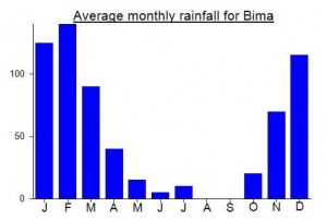
Local Average Monthly Rainfall (mm):
Location
Click on the blue arrow ![]() (top right) to see your current location on the map
(top right) to see your current location on the map
https://www.ii.uib.no/~petter/mountains/1500mtn/dorodindi.html
More support for Doro Dindi comfortably being an Ultra-prominent peak (P1500 plus).
It’s funny how you can have completely different perceptions of the same place on different occasions. My previous two trips to Sumbawa left me feeling that it wasn’t one of Indonesia’s friendliest islands. This third trip (and second to this particular mountain) was, I am pleased to say, quite the opposite.
I flew to Lombok on Friday night and after dealing with the typical feral atmosphere outside the airport stayed at one of the hotels close to the airport. Happy to see they had beer, so I ordered a bottle. Amusing how such a simple purchase could get so complicated, but they had no change available so I was advised to pay at 5am the next morning at I checked out for my early flight to Bima. Next morning, the other member of staff had no change either, so another guy had to drive to the local Indomaret to buy some cigarettes for him and provide me with change!
Garuda to Bima is currently 6am, which means pretty good views of Rinjani, the Olet Sangenges range in West Sumbawa, Tambora, and then finally Doro Dindi and Doro Leme as we descended into the tiny little airport of Bima bay. Got an ojek up to Padende for 150,000 which was a fair price I think. At Padende folk were really really friendly and one guy was using English and offering help. When I said my plan of hiking this gunung he dropped his things and we set off up the hill less than 3 minutes later. Amiruddin – a genuinely decent guy (08533 9846133).
I asked if any local students or nature lovers had been up here recently, but he said that nobody had been past the stream, except for a small number of local villagers. He himself had never been to the summit so was keen on this adventure. 2 more villagers joined, both intrigued!
Whereas last time I trekked with local students up to the right after the stream, we sensibly tried the vaguer trail leading up to the left on the other side of the stream. We saw a snake but didn’t get much of a look at it, but do watch out for them in this area. The locals must have thought I was mad as I regularly informed them how high up we were and how many km or metres we were in a straight line from the summit. Really nice rocks in places on this trek and the views might be reasonable in less cloudy weather than we had.
After a few cuts from thorns etc we finally made it to the top. Unmarked, but the remains of a small fire. Not the most impressive summit but great to have made it. My GPS gave a reading of around 1623-1628m, so the 1618m on the old military map is a fairly conservative figure and even with that Doro Dindi appears to have enough prominence to be an Ultra (it has long been listed as borderline or almost an Ultra). I feel confident enough to say it probably is an Ultra. It took us 3 hours up and 2.5 hours back down.
Once back down, we made a quick trip to the nearby inscribed stone. Worth a quick visit, although if the entrance is locked (probably will be) you will have to be content with photos through the metal railings. Then I got ojeks back to near the airport and checked into the Kalaki Beach Hotel, which could be great (as it is near the airport and has good sunset views of the bay and planes landing) but had no food or beverages available (and there are no shops for several km).
Got the early morning Wings flight back to Lombok, enjoying the views over a couple of weird volcanic landforms on the southern end of the Tambora peninsula (cinder cones?) and then had a 5 hour wait for connecting Lion flight to Jakarta. This was delayed by 2 hours (typical!) and during take-off I was rather worried at an unusual, juddering noise coming from the front of the plane. For a moment I didn’t think we would manage to takeoff but thankfully we did. Flew directly over the Gilis, and it is there that I saw constellations of glitter stretching across the ocean, for a good 20 minutes of the flight, or to near the south coast of the island of Madura. Obviously this glitter was nothing nice but sadly rubbish polluting the oceans and being lit up by sunlight shining at a particular angle. A weird vision.
When the news came in the following day of the Lion aircraft having crashed in the sea after takeoff from Jakarta I thought back to my own experience and double checked to see if it was the same plane. Thankfully not, but when these horrible accidents happen you realise that you are far from immune and that it could easily have been you or your aircraft.
I hope to be back in Sumbawa next year to try Doro Maria/Daria on the other side of Bima bay and maybe Olet Takan near Sumbawa Besar airport which is very close to being a Ribu (maybe 999m prom). Seems like West Sumbawa calls hills Olet and East Sumbawa calls them Doro.
This peak may also be known as “Doro Lambuwu”. Geonames has that name at this location, -8.3938, 118.5426 (http://www.geonames.org/1638582/doro-lambuwu.html) with elevation 1628, and has “Doro Oromboha” a couple km to the north at -8.36667, 118.53333. (http://www.geonames.org/1633542/doro-oromboha.html)
Well, this wasn’t one of the better weekends I’ve spent trying to hike in the mountains here in Indonesia. Indeed, it was so frustrating at times that I started to consider what i was doing in the country anyway. Maybe I should move elsewhere, Greenland perhaps.
I woke up at 2am on Saturday in order to catch a flight to Bali and from there to Bima in Sumbawa. I had already arranged for a guide to meet me at the airport at 09.45. They assured me they would be ready to meet me. At 09.45, the guide was nowhere to be seen and I was getting mildly harassed (in the usual way) by locals trying to make a quick buck from overcharging a foreigner for transport somewhere. I appreciate they need to make a living but it becomes tiresome when you have to say ‘no, don’t need transport’ every 30 seconds.
I was left fending these people off for about 40 minutes before the guide (and friend arrived). Amazing… I had flown all the way from Jakarta to climb Doro Oromboha yet these two couldn’t even arrive on time to meet me despite living just 20 minutes or so away. You could just say ‘it’s the Indonesian Way’ to never be on time but I think it shows a lack of manners. Is it really necessary to bombard a guide with messages saying ‘do not be late’? Or should I have simply told them I would be arriving three hours before the actual time I was due to arrive? So we got off to a bad start.
This was even more of a problem because we did not have a great deal of time to climb before dark. So I told then we would go straight to the mountain (as previously arranged). We got there after about an hour – quite a pleasant journey actually with some great scenery.
Upon arrival at the trailhead we had to speak to the local village chief. He was friendly, but as soon as we got inside he brought out the plastic chairs which, to anyone in a hurry, is a dreadful sign. So it was another 30 minutes of idle chat and I was desperate to get hiking finally instead of sitting in a darkened wooden house being asked the same boring questions about which country I was from. Fine if you have all day to discuss things, but my time is limited due to having to be back at work first thing on Monday morning in Jakarta.
A couple of the guides’ friends arrived, curious and keen to come along. I have no problem with this, as long as it doesn’t interfere with progress. Unfortunately it did – they were rather slow. After just 40 minutes of hiking we reached the river and they wanted to take a break. Ok. 20 minutes into the break they decided it was time to eat. So total break time 45 minutes. It was already nearly 2pm and I was eager to continue.
If the trail had been straightforward from this point we wouldn’t have had a problem getting back before dark (something I was keen on, having woken up at 2am). Alas, it got very confusing here and the terrain was quite easy to become lost in. That we had extra hikers coming and slowing us down made it even worse as we had to keep calling to each other to check where they were.
We kept on going for a further hour but got no closer to the top (you have to go right to the shoulder of the mountain before heading left) and it really wasn’t the sort of place to be messing around in after dark. So, by 3pm, I was utterly fed up, and decided we should head back. It was a totally unpleasant experience – I am paying to basically wait and wait for the so-called guide to arrive at the airport then for him to finish eating and for his mate to finish praying. Just awful manners. Who is guiding who? To pay for someone to slow you down to the point where you have to turn back because of all the delays is just a joke. I wish these people could even begin to consider what it might be like to not be one of them but the person who is paying them to take them up to the top. It seems they have very little ability to see things from someone else’s perspective.
I was fairly annoyed after having come such a long way from Jakarta for this to happen and so I cancelled the proposed climb to the nearby Doro Leme the following morning as I didn’t think they deserved a penny more. Luckily the hotel in Bima was pretty nice so I had a good long sleep and then woke up to question why the hell I was doing any of this anyway.
A lot of Indonesians seem to think that time doesn’t matter. You can show up an hour late, and dawdle, take a rest for an hour to eat some rice. I suppose they don’t have jobs to go to. Or if they do, perhaps they just show up 2 hours late. Frankly, these guides should have paid me to go with them rather than the other way around. It was a dreadful waste of money (expensive to fly Jakarta to Bima and back) and time and it could have been avoided if they had shown just a tiny amount of respect by showing up on time and going at my pace rather than their own. Atrocious.
Thanks for wasting my time chaps. We could have easily reached the top if you had not been so selfish. It is this sort of experience that makes me think maybe I should pass on the gunung bagging baton to someone else, because my patience has been tested so much lately by this type of person.
It would, of course, be great if we actually received some funding for this site – I think since 2009 we have received just one donation (and of course no interest from, say, the Indonesian tourist agencies, despite the enormous potential).
If time was not a problem and I could spend a longer time exploring these places then all the delays would not be such a problem. As it is, I sacrifice my weekends and a large portion of my salary to build a website which promotes Indonesia to the English-speaking world. When I go to such lengths and am treated so poorly by local people I begin to wonder why I bother. Perhaps they don’t deserve it. So, thanks a lot for a crap weekend.
And it wouldn’t be an issue if this was a one-off. But it isn’t… the best hikes I go on are those without guides, such as to Welirang last weekend. When you take guides, 50% of the time they slow you down and want to eat at every opportunity and refuse to follow your pace but rather expect you to go at theirs. Anyway, perhaps my next trip will be a bit better and I’ll get the enthusiasm back.
Dan,, I am really sorry for what you experienced..
I apology to you from the bottom of my heart.
Jangan kapok datang ke Indonesia..