Facts
- Elevation: 1,785 m (5,856 ft)
- Prominence: 995 m
- Ribu category: Spesial
- Province: Sulawesi Tengah (Central Sulawesi)
- Google Earth: kml
- Rating:

 (4 votes) Add your rating
 Loading...
 - Other names: Named ‘Bulu Sinio’ on the Bako map and known as ‘Puncak Semen’ to locals.
Photos


Bagging It!
Gunung Sidole is the highest point of a long mountain range which stretches northwards from the city of Palu. These hills are densely-forested ridges with a remote atmosphere, yet this is the narrowest part of the island of Sulawesi, with less than 30 kilometres from west coast to east coast. Views to both coasts can be enjoyed from the summit of Gunung Sidole, and the trail is becoming increasingly popular with student hikers such as those from the many hiking clubs at Palu’s Tadulako University – some of whom conducted expeditions to open the routes originally.
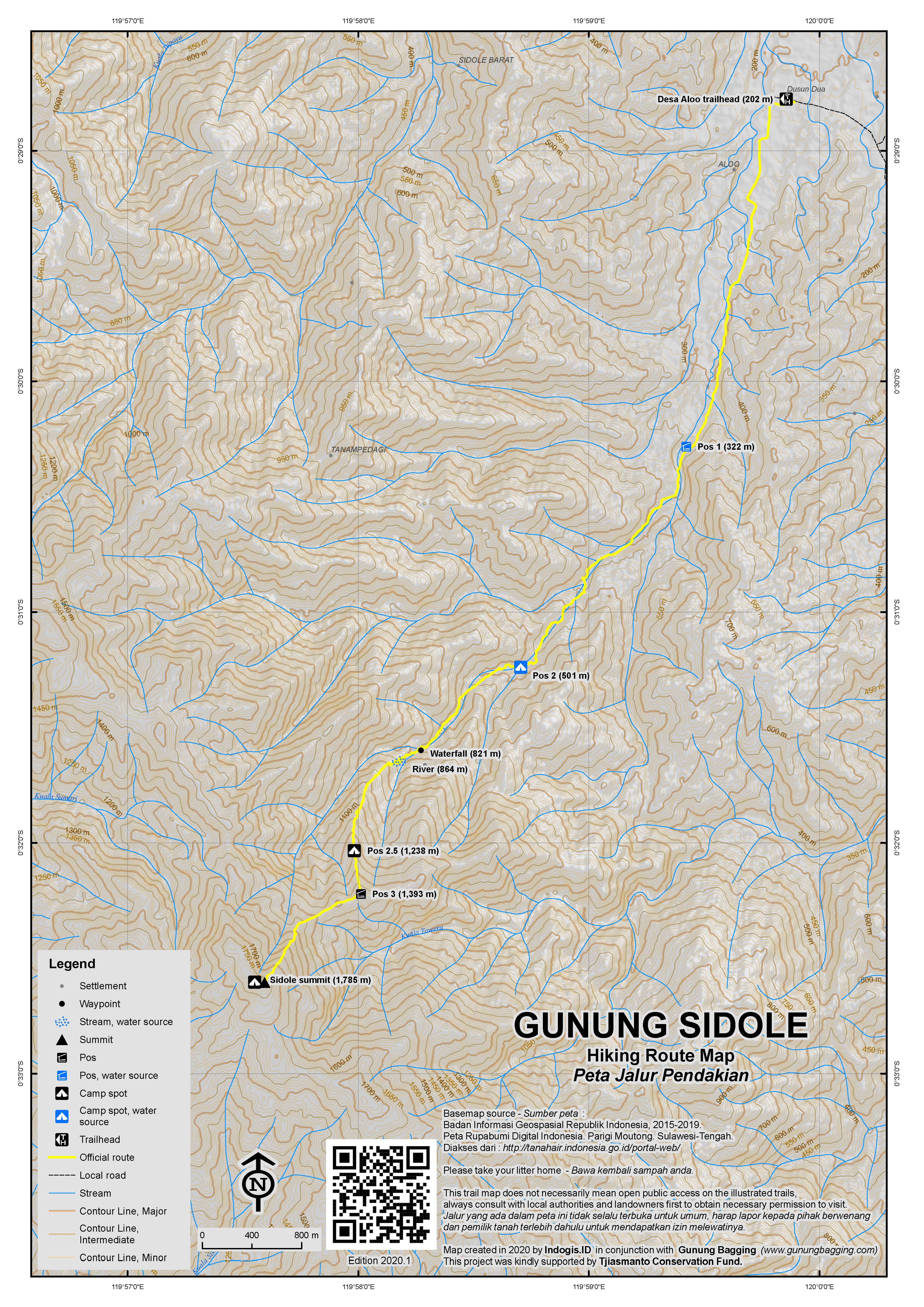
Gunung Sidole can be climbed from the west side just one hour from Palu city at Desa Taripa or Desa Sisera (south of Taripa). Both approaches have trailheads at only around 100m above sea level, and are long (12km in a straight line from the trailhead to the peak, but lots of ups and downs and typically requiring 3 days up and 2 days down) and on rarely-used trails which are easy to get lost on. Indeed, one group got lost in 2017 when approaching Sidole from the west side. To reach the Taripa trailhead, take a right on the main road at Toaya onto Jl Dindimaka. Follow this straight for 20 minutes over a wooden bridge and past Taripa and to the end of the road at a river and wooden shelter.
The steeper and shorter eastern route starts at Desa Alo’o, near Ampibabo, and though it takes about 2 and a half hours to reach by car from Palu it is the most commonly used route. Sidole cannot be seen from the western trailhead but can be seen from the eastern side (though it is often shrouded in cloud). From Alo’o (pronounced “allo-oh”) strong hikers could reach the top and return in two days but, given the distance to/from Palu and the lack of accommodation nearby, it is best to spread it over three days with one half-day either side and the middle day the really long one. It is possible to fly in to Palu from Jakarta very early on Day 1 and arrive back in Jakarta on the evening of Day 3 having completed the hike.
To reach the Alo’o trailhead (202m), head over to the Trans-Sulawesi highway on the east coast, north towards Ampibabo and turn left at the blue monument at Desa Toga (‘tugu toga’) via Desa Sidole towards Desa Alo’o. It is about half an hour inland from Desa Toga to Desa Alo’o, but the last couple of kilometres are steep and you may need local ojeks instead of a car to get past Puncak PID (‘program inovasi desa’ – innovative village program) which is a little decorative viewpoint to the east coast before the road enters Desa Alo’o.
Any villagers in Alo’o will point you in the direction of the house on the left where you should register in the registration book before hiking. Many locals know the peak as ‘Puncak Semen’ (cement peak) due to the pillar at the top. Foreigners should expect to be asked for numerous photographs here with villagers. A group of local hikers – KPA Laskar Puncak – may wish to accompany you, if not to the top then up the river as far as Pos 2 which is a good spot to spend the first night, if not both nights.
From Alo’o to Pos 1 (322m) takes about 1 hour. The trail leads through cocoa plantations by the side of the Alo’o River (Sungai Alo’o) but some hikers find it easier to simply walk up the river itself. Pos 1 is a few planks of wood by a large tree next to the river, and would be easy to miss by those using the plantation trail as opposed to wading up the river. There are no signs here but it makes a decent place to have a short break before proceeding to Pos 2 which requires another hour and numerous crossings of the river before the trail simply becomes the river itself! You will definitely get your feet wet, so either bring comfortable and sturdy sandals, or prepare to have wet hiking boots for the rest of the trip.
Between Pos 1 and Pos 2 as you head upstream there are some lovely narrow sections of river with minor cliffs on either side. Pos 2 (approximately 501m above sea level) is a flat spot next to the river with several signs on a large tree and a chilli plant. There is enough space for about 3 tents and, depending on which onward route you take, is allegedly the last place with a reliable water source before a spot 30 minutes beyond the summit. It is best to fill up here.
From Pos 2 to Pos 3 takes 4 or 5 hours, and there are two different routes to choose between. The original route takes 5 hours but is slightly clearer and less steep than the new direct, steep, spiny and vague short cut route which takes around 4 hours. This is the section where you will encouter leeches and it is advisable to wear a hat or similar to cover your ears as there are quite a few very small leeches that are difficult to notice. For the adventurous, the new short cut direct route to Pos 3 may be a good choice, but be warned! If you are considering camping higher up the mountain then the original, longer route to Pos 3 is probably a better idea as you may struggle to take large backpacks up the short cut route. On both, take real care as there are some very steep sections and often very little to hold onto other than huge spines. Gloves are recommended for additional protection.
Pos 3 (1,393m) is at the lower end of a ridge leading up to the summit, which is just over 1 kilometre away. There is some space for camping but the ground is lumpy due to tree roots. If taking the short cut route up here, there is another flattish spot about 20 minutes before reaching Pos 3. From Pos 3 to the summit takes about 90 minutes. The trail first descends a little bit, including over recent treefall, before ascending steeply up for the last hour or so. The forest is very pleasant, but as is typical there are few views to be had between the trees.
Finally the grassy summit is reached. This is by far the best spot for camping, with plenty of space and nice views to both east and west. Alas, getting big backpacks all the way up here and back down within 3 days would be quite tough, though doing a four-day traverse from east to west would make a great expedition.
The summit is crowned by the remains of a cement pillar which is presumably an old Dutch trig point and was likely hit by lightning at some point leading to its break-up. There are a few signs nailed to bushes and trees, plus a tomato plant and a citrus bush! Although the views east to the coast of the Gulf of Tomini are pleasant, the best by far are to the west. From the cement pillar you look down to Palu bay, with the Tanjung Karang peninsula beyond, Palu city at the head of the bay, and the mountains of Bulu Nti and Gawalise behind.
You may also notice some old bits of metal machinery at the top of the peak. This is part of the wreckage of a plane which crashed in 1974 down to the west of the summit. The crash site itself requires an hour to reach from the summit and you would need locals to help you locate it. Beyond the cement pillar is a trail to a water source, which takes 20 minutes or so to reach.
The mountain is named Bulu Sinio on the Bakosurtanal map (Tavali) and the US Army maps from 1954 but this seems to be either an error or an old name that has fallen into disuse given that no locals have heard of this name. On the US Army map, ‘Bulu Sidole’ is the name of a lesser peak a few kilometres further north beyond Gunung Balia (another lesser top). However, the Bako summit height of 1785m and US Army map height of 1786m are seemingly very accurate based on GPS readings, meaning that Sidole fails to qualify for Ribu status by just 4 or 5 metres of topographic prominence! Some provincial and national maps list Sidole as being 2,099m high but this is definitely incorrect.
Apparently the mountain is home to lots of tarsiers and a small number of anoa but we didn’t see or hear any on our trip. We did hear plenty of hornbills between Pos 2 and 3.
To descend from the summit to Pos 3 takes about 90 minutes and from Pos 3 to Pos 2 another 4 or 5 hours. It is then another 2 hours back to Desa Alo’o so basically the same amount of time down as on the way up. The recommended itinerary for those wishing to hike up from and back down to Desa Alo’o is to Camp at Pos 2 for 2 nights, with the middle day for reaching the summit and coming back down again to Pos 2 (10-12 hours total).
Bagging information by Dan Quinn (December 2017)
Trail Map
For a high quality PDF version of this and other trail maps, please download from our Trail Maps page.
Local Accommodation
Practicalities
- Getting there: The western trailheads are about one hour’s drive from the city of Palu where there is an airport with direct flights to Jakarta and other cities. The best trailhead is at Desa Alo’o to the east of the mountain and requires closer to 3 hours to reach from the city.
- Guides and GPS Tracks: Want a PDF version for your phone? Looking for a guide? Need GPS tracks and waypoints? Gunung Sidole information pack can be downloaded here.
- Permits: If hiking from the east at Desa Alo’o, pleas register in the village and perhaps take a spare photocopy of your passport or ID card to give them.
- Water sources: On the eastern route, river water is available to Pos 2 and beyond, plus a limited and perhaps unreliable supply 20 minutes beyond the summit.
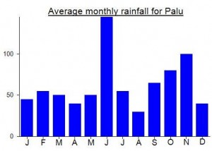
Local Average Monthly Rainfall (mm):
Well done! Glad that you again exploring indonesian archipelago, Dan!
By the way, I going to come to Indonesia soon, so my nearest plans is to scale all of prominent ribus in Sulawesi! Hopefully see you there soon!
I had originally hoped this would be my 69th Ribu but a few days before setting off for Palu I searched Instagram for Gunung SIdole images and found one with a sign with 1785mdpl on it. I wondered where this figure had been taken from. We had given it a tentative height of 1803 given that max SRTM is 1788 and summits in this part of the world are almost always at least 15 metres higher than the SRTM (some are closer to 40m higher). Anyway, at Lalimpala HQ we looked at a photocopy of the Bakosurtanal map which gave a summit height of 1785….. given that Bako maps are pretty good for Sulawesi I was a bit concerned that Sidole would not be 1790m or higher, and therefore not be a Ribu.
It did indeed turn out to be the case. With my GPS hovering arounf 1784-1788 I think the 1785m is about right. The GPS did hit 1790/1791 for a second or two but not for long enough to suggest that the mountain has an elevation of 1790 or over. Never mind – it’s a decent hike anyway!
Many thanks to Ronald/Onald whose blog I read about SIdole for putting us in touch with Ojan and Jonga who were very competent.
As expected, lots of animal life in the forest here… loads of bugs, snakes, bees, hornbills, several types of leeches, and possibly a scorpion at Pos 2. The spikiness of the foliage between Pos 2 and 3 was some of the most daunting I have ever seen, especially on the way back down… nothing to hold onto except vines as we made Tarzan-esque moves down steep muddy slopes to get back down to the river. Myself and Helene each got stung once by bees, but no ill effects.
The original plan was to camp at Pos 3 the first night and Pos 2 the second night, but given the lack of water at Pos 3, and that it would be a further 4 hours on our first day after very little sleep the night before, and that our guides would be happy to set off for the summit at 1am so that we could be up there shortly after dawn for hopefully the clearest views, and we decided to stay at Pos 2 both nights. This turned out to be a good move as Pos 3 was a bit more lumpy than Pos 2 and dragging our large backpacks with tents in them would have been a real drain on little sleep. We reached the top before 7am… perhaps 5 and a half hours after leaving Pos 2, and the summit was covered in cloud, strong winds blew the branches back and forth, and rain drizzled down. Very British weather. Luckily we stayed there for over 2 hours and the sky cleared and the sun came out. Grand views to make up for the GPS reading confirming that Sidole is probably not a Ribu. If you want to guarantee to reach the summit for first light and are setting off from Pos 2 them I recommend leaving no later than 12 midnight. It’s a long day. The second night I went to sleep at 6pm and didn’t wake until after 6am. My knees were badly grazed from clambering over rocks in the river with wet trousers on and a heavy backpack, but Day 3 was easy… just two hours back down to Alo’o.
In both directions, the villagers were very excitable and cameras were everywhere! A very pleasant local chap called Juliadi can be contacted on 087842832284 if you want to arrange a guide/porters in advance from Desa Alo’o. He said one of the group photos of us plus the villagers would be printed out and put up on a wall. Quite an honour! The guys from KPA Laskar Puncak were very tough – one of them had been up 14 times and was able to get a fire going in the rain using inner cuts of Pohon Damar (resin tree).
Note that not far from Toga (the junction on the Trans Sulawesi highway for Desa Alo’o) is a place called Desa Tolole which has air panas (hot water) on the edge of the beach. Might be worth checking out. Also consider stopping off at the top of the windy snaking road that heads over the hills from west to east coasts and is a considerable portion of the journey from Palu to Desa Alo’o. There are some nice viewpoints including Bukit Kesepihan. We were back in Palu by early afternoon on the third day, so I looked up the pizza place that I had eaten in the first time I came to Palu a few years ago. Tropiz Maestro Pizza. Slow service but superb pizzas and Bintang beer available! Recommended.
Batik Air back to Jakarta via Makassar was on time and the sun had just set as we swooped round the Tanjung Karang peninsula with a full moon above the aircraft and a silhuoutte of Gunung Gawalise with a red sky backdrop. Lovely. No rain enroute, perhaps after the two very recent tropical cyclones south of Java had cleared everything away with them.
Jakarta Reality returned with a bump at Terminal 1 Soekarno Hatta, as the luggage belt information screen had the usual incorrect information on it. Instead of updating it to show the correct information, they decided to send round one boy to tell customers individually that they were waiting at the wrong luggage belt! When will they learn that no information at all is better than incorrect information and that screens are not merely there to present the facade of a well-managed airport! Outside, the queue for taxis was immense. They have a system in place whereby instead of several people boarding taxis at the same time, you are supposed to do it one-by-one. This is, of course, totally inefficient and leads to congestion of both customers and taxi drivers. I just walked to the back of the queue and over to a Taxiku and got in it. After winding down the window to get the daft security boys to get out of the middle of the road and let full taxis leave the airport we finally crawled forwards. No problem with the journey into the city, except of course for the driver accelerating towards the back of a truck on the toll road and me having to yell out to alert him! Hilarious fun, if you don’t have to get up for work at 5am the next morning…..
Will be back to Palu later this month for Bulu Nti (another borderline Ribu with hopefully 1012m prominence) and the easier Nokilalaki. Can’t wait – a good spot to be in when the rains have arrived in Java.
SIdole has now been ‘demoted’ to a Spesial.
With the help of some very pleasant chaps from Lalimpala (Universitas Tadulako) went to have a look at the base of this mountain (and Bulu Nti) at the weekend in preparation (hopefully) for a significant expedition to Sulawesi next year. I was taken to the western trailhead (which is closer to Palu) but I reckon the shorter, steeper one from the east sounds better – or perhaps a traverse might be called for.
On Saturday night I stayed at the rather expensive Prince John Dive Resort for an excellent view across Palu Bay to Sidole (which appears much less of a peak as merely a high point in the middle of a mountaineous area). A couple of tame Cuscus came down when tempted by one of the staff’s food and there was bir bintang galore. Do watch out on the road out to Tanjung Karang, however, as we got a flat tyre in both directions!
Just received the email below from Lalimpala Mapala student hiking group in Palu, Central Sulawesi regarding this mountain and also Kandela (referred to below as Gn Katopasa).
google translate:
for Dnaile ….
sorry, late reply to your e-mail!
thank you if you are interested in mountain climbing to sidole.
organization coincidence I’ve been doing the opening track to the top of the mountain climbing sidole.
there are 2 lines that have been open:
1. east coast route, start sidole village. travel about 3 days, open julur in 1996 but the line was the last time in the past in 1999.
2. West coast path, starting from the village Taripa. travel about 3 days. open path in 2005 and until now often used.
daily average of 6-8 hours of travel, the spring rather melimpah.kemudian to peak a little closed but there are some areas around the summit which could see the sights Tomini Bay (east) and Gulf hammer / gawalise mountain (the west).
if you are interested in a more challenging angle view, I recommend a mountain located in the district of Tojo Una-Una sul-teng. Gn name. Katopasa altitude of about 2878 masl, the travel time of 5 days (every day 7-8 hours journey), scrambling on the ascent route on day 3. is the habitat Anoa (Central Sulawesi endemic animals) and the top slightly open with a view of the nature reserve Morowali (east), Tomini Bay (west). This route was opened since 1996 and until now a favorite of climbers Central Sulawesi because the track is varied and many see the flora and fauna on the way a little extreme with his scrambling route.
that while information can I share to you, may be useful.
This contact us:
Halis (085249107630)
green regards
original:
for Dnaile….
maaf, lambat membalas e-mailnya !!!
terima kasih kalau anda tertarik untuk mendaki ke gunung sidole.
kebetulan organisasi saya sudah melakukan pembukaan jalur pendakian ke puncak gunung sidole.
ada 2 jalur yang telah terbuka :
1. jalur pantai timur, start desa sidole. perjalanan sekitar 3 hari, buka julur tahun 1996 tetapi jalur ini terakhir kali di lewati pada tahun 1999.
2. Jalur pantai Barat, start dari desa Taripa. perjalanan sekitar 3 hari. buka jalur tahun 2005 dan sampai sekarang sering digunakan.
sehari rata-rata perjalanan 6-8 jam, mata air lumayan melimpah.kemudian untuk puncaknya sedikit tertutup akan tetapi ada sebagian area sekitar puncak yang bisa melihat pemandangan teluk tomini (arah timur) dan teluk palu/pegunungan gawalise (arah barat).
kalau anda tertarik untuk angle pemandangan yang lebih menantang, saya rekomendasikan satu gunung yang berada di wilayah kabupaten Tojo una-una sul-teng. namanya Gn. Katopasa ketinggian sekitar 2878 mdpl, waktu tempuh 5 hari (setiap hari 7-8 jam perjalanan), jalur scrambling pada pendakian di hari ke 3. merupakan habitat ANOA (hewan endemik sulteng) dan puncak agak terbuka dengan pemandangan cagar alam morowali (timur), teluk tomini (barat). jalur ini dibuka sejak tahun 1996 dan sampai sekarang menjadi favorit para pendaki sulteng karena jalurnya yang bervariasi dan masih banyak menjumpai flora fauna dalam perjalanan serta sedikit ekstrim dengan jalur scrambling-nya.
itu sementara informasi yang bisa saya share ke anda, semoga bermanfaat.
ini kontak kami :
halis (085249107630)
green regards
Mahasiswa Pecinta Alam “LALIMPALA” Universitas Tadulako Palu Sulawesi Tengah.