
Facts
- Elevation: 1,653 m (5,423 ft)
- Prominence: 1,020 m
- Ribu category:
 Kurang Tinggi
 - Province:
 Jawa Timur (East Java)
 - Coordinates: -7.6156, 112.6200
- Rating:


 (17 votes) Add your rating
 Loading...
 - Other names: Pawitra
- World Ribus ID: 69211
Photos


Bagging It!
Penanggungan is a small now-dormant volcano situated just to the north of the huge Arjuno-Welirang range. It used to be called Gunung Pawitra (now the name given to the summit area) because of the fog which often covers the peak so make sure you set out early to reach the top before the haze and cloud rolls in! Accessibility is not a problem as it is only a short distance from the main road connecting Surabaya with the pleasant city of Malang.
Penanggungan is a particularly revered mountain and has many ancient Hindu temple sites on its slopes – as many as eighty according to Dutch archaeological investigations conducted in the 1930s which were begun after a forest fire uncovered some of the ruins.
This whole area is a fascinating reminder of Java’s pre-Islam history and the Majapahit kingdom. It is quite tempting to try to visualize how this mountain would have be used centuries ago.
There are several approaches to the peak and they each have their advantages and disadvantages. Because of the abundance of accommodation in the mountain resorts of Trawas and Tretes, many people choose to start south or west of the peak and this is arguably where the best views of the mountain are to be found. A good budget place to stay is PPLH Environmental Education Centre, west of the mountain, where you can also find guides for the Jolotundo route.
As a rough figure, allow 4 hours to reach the top and 2 and a half to descend. Remember sun cream for this trip because Penanggungan is an unusually unforested peak so there is very little shade to be found and even local hikers describe it as hot!
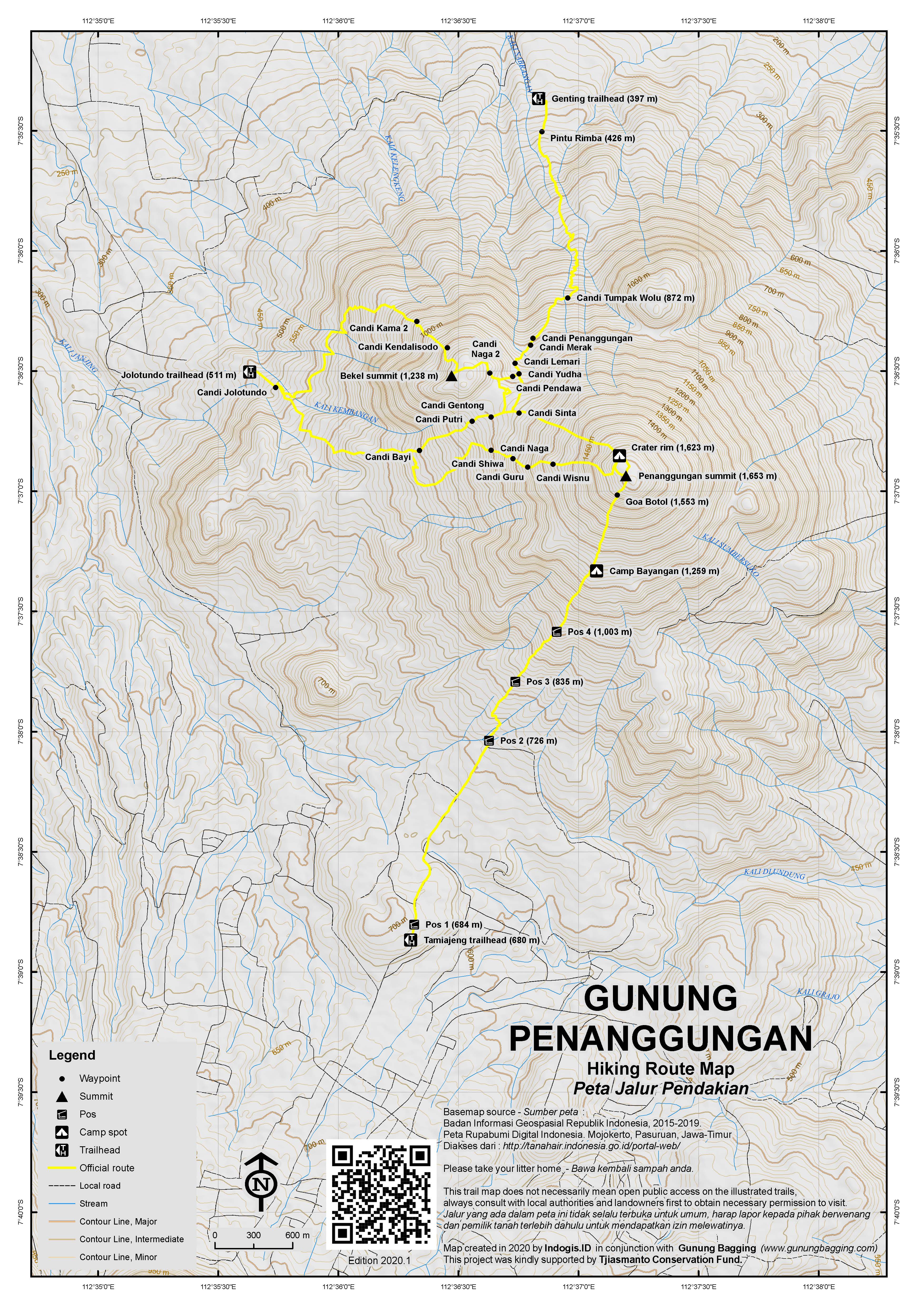
Below is a list of the main routes. It is obviously more interesting if you ascend by one route and descend in a different direction.
Starting from Candi Jolotundo (west of the peak)
One of the best-known starting points for the hike is in the west at Candi Jolotundo (511m), a temple built in approximately 977AD and one of the oldest and most sacred. The temple is a very popular place for Indonesians to visit and bathe and there is information and a small office booth where you will almost certainly be able to locate a guide for climbing. This is important because the trail is not always very clear and there are numerous farm tracks near the start which can add to the confusion. The Jolotundo route passes many sites of great interest.
The trail from Jolotundo leads up through plantations and beyond various farm huts. As the trail leads onwards up the hillside, the prominent subsidiary peak Bekel (1,238m) comes into view to the left of the path. There are many farm trails here so if in doubt ask one of the friendly farmers for help. The route is subtly marked with red arrows (and red crosses to indicate the wrong way) painted on rocks and trees. After you have ascended beyond the farmland, the trail gets steeper and less clear. However, there are several ancient temples on the higher slopes, at intervals of approximately 200 metres, which more than make up for the overgrown path. These Hindu temples are very interesting monuments and, considering the steep, overgrown and narrow trail, probably not often visited.
They feature central stairways and terraced walkways with a few stone carvings. Each temple has a small grassy lawn infront of it which is neat and in good condition – evidence that local people do care for these relics. Elevations and names are as follows: Bayi (909 m), Putri (1,083 m), Pura (1,110 m), Gentong (1,144 m) which is a mini temple next to a large stone resembling an empty jar, and Sinta (1,157 m).
If the weather is good, you should be able to see the remarkable, jagged outline of Gunung Anjasmoro‘s Boklorobubuh peak to the south-west. Beyond the temples is a small cave. From here, the top of Penanggungan is clearly visible and it should take you only about another 30 minutes.
The alternative option is to take a left near Candi Sinta along an overgrown and faint trail and head to the lesser peak of Gunung Bekel which has several more temples and sees far less visitors and is therefore much cleaner. Be warned that this can take a full day to explore.
Assuing you continue to the highest peak of Penanggungan, the grassy spot is a lovely spot to sit down for lunch. In fine conditions you should be able to see the northern coastline, Arjuno, Liman, and perhaps Semeru and Argopuro. The shallow grassy bowl-like depression just below the peak is all that remains of the crater. The summit area is an almost symmetrical shape, and pretty much aligned to the cardinal points – probably one of the reasons why ancient people regarded this mountain as being of such great importance.
Starting from Tamiajeng, Trawas (south-west of the peak)
This route is the ‘official’ route that is most heavily promoted and is now the most popular. It starts fairly high up at the small ticket office (680m) and Pos 1 warungs at around 684m above sea level. It is clearly signposted but due to its popularity there is more litter on this trail than some of the others. It is the shortest and steepest of the routes and comes out directly at the highest part of the summit rim. Allow about 3-4 hours up and 2.5-3 hours back down.
The trail passes by another warung (670m) with a very friendly owner and some good views of the peak from nearby before leading up via Pos 2 warungs (726m), Pos 3 (835m), Pos 4 (1,003m) and the remains of a temple (1,070m). Next is Bayangan (1,259m) which is a popular place to camp as the views are great because there is no more forest from here up to the summit.
There are not many temples to be seen on this route (seemingly just the ruined one at 1,070m) but it is a great option to combine either before or after one of the more interesting and less well-used routes.
Starting from Dusun Telogo, Desa Kunjorowesi (north-east of the peak)
The advantage of this route is that it is not very far from Sidoarjo and the main Malang-Surabaya road. The mahogany woodland is also beautiful. It starts at around 700m.
Starting from Dusun Betro, Desa Wonosunyo (east of the peak)
Similar to the Kunjorowesi route but starting due east.
Starting from Genting, Ngoro, near Candi Jedong (north of the peak)
Starting at an elevation of only around 397m, this is the longest and toughest of the hikes and that is perhaps one of the main reasons it is not very popular despite being on the industrial Surabaya side of the mountain. Allow 4-5 hours up or 3-4 hours down.
It is actually rather wild forest here despite the continual hum from the traffic and factories in the northern plains below. The trail is partially marked but it is recommended that you seek a guide at nearby Jedong temple because the higher parts are rather vague and often overgrown.
On the plus side, there are lots of temples on this side, notably including Candi Tumpak Wolu (872m) which is partially collapsed and engulfed by the surrounding forest landscape.
The next landmarks are all temples that are in better condition and clearly cared for, many with neat mini hedges surrounding them. Candi Penanggungan is at 995m, soon followed by Candi Merak (1,005m), Candi Lemari (1,045m), Candi Yudha (1,066m) and Candi Pendawa (1,080m).
It is around here that the trail can vanish into dense vegetation if nobody has used it recently but with a good guide or a bit of luck you should be able to join up with the Jolotundo trail at Candi Gentong (1,144m) or Candi Sinta (1,152m). In order to do this you need to veer to the left or simply follow the clearest trail over the col until you meet a junction. Otherwise you might end up at Candi Naga on the side of Gunung Bekel to the right (as noted above, a fascinating but wild area requiring several extra hours to explore). Once on the Jolotundo trail it is then just the final slog up to the summit.
Bagging information by Daniel Quinn (last updated November 2019).
Trail Map
For a high quality PDF version of this and other trail maps, please download from our Trail Maps page.
Practicalities
- Getting there: For domestic flights from or to East Java, such as the airports in Surabaya, Malang and Banyuwangi, we recommend Baolau. Lots of public transport available between Surabaya and Tretes. You may need an ojek to the starting point.
- Guides and GPS Tracks: Want a PDF version for your phone? Looking for a guide? Need GPS tracks and waypoints? Gunung Penanggungan information pack can be downloaded here.
- Trip planning assistance: Would you like Gunung Bagging to personally help you in arranging your whole trip? Please contact us here.
- Permits: Tickets available at the main entry points such as Tamiajeng. Rp 10,000 per hiker (2019).
- Water sources: Unknown – take sufficient supplies with you.
- Accommodation: Try the Booking.com map above or use this link to search for suitable hotels, homestays, resorts and apartments for your trip.
- We recommend Safety Wing as travel insurance for overseas travellers and tourists hiking up to elevations not exceeding 4500 metres.
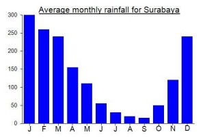
Local Average Monthly Rainfall (mm):
Location
Click on the blue arrow ![]() (top right) to see your current location on the map
(top right) to see your current location on the map
Origins and Meaning
(not clear). In Old Javanese tanggung means “to bear a burden, to take on a burden” so pananggungan might mean “the place where the world is supported” (compare Gunung Sanggabuana). The Penanggungan Plateau has been a sacred place from distant times (there are significant pre-Islamic ruins to be seen there today), so it is possible that the name of the place reflects its ancient function – a place where ascetics and kings “took on the burdens of the world” by connecting with the deities of the sites. (George Quinn, 2011)
Had an arvo hike up Pengganungan with my wife. We left from the gate at Tamiajeng near Trawas, around 2 in the arvo and we were at Pos 4 by 330. When we arrived at Pos 4 the rain began to fall so we called it a day and headed back down. From the bike parking to Pos 4 and back to the bike parking took 3 hours.
It was a very pleasant experience with the people working there. 10k for parking and then 10k per person for entry. The guy working in the booth just takes your name and phone number and then crosses you off when you return. Heaps of Indoensian teenagers hiking up to camp on the mountain. Will be back in the dry season to give it another try .
Penanggungan, the classic Majapahit mountain. But if you want to hike it during Ramadan you will struggle to find a local guide at the basecamps. I was hoping to do a trek from the east with a local friend, my third peak of three planned for the week. Amazingly he got the date wrong and never arrived to pick me up so of three peaks in East Java I managed to hike zero, none due to lack of fitness or desire to hike! Unbelievable. The first due to it being closed for all of Ramadan, the second due to it being closed to all foreigners due to covid, and the third due to my hiking partner getting confused! In normal times I would say a couple of bottles of Bintang might be necessary to help deal with such a dismal week but it’s illegal to sell alcohol in Surabaya during the holy month. Not a great experience but certainly rather fascinating! I’ll be back in a few years to see if things have declined even further! Perhaps it’ll be even more like Saudi Arabia!
Did a traverse of the mountain from north to south on Friday night / Saturday morning, using two routes I hadn’t tried before (last time was up from Jolotundo and down to the east) – one of the least popular namely Genting, Ngoro and then down to the most popular one at present namely Tamiajeng.
At Surabaya Airport, I had the usual scrum of taxi drivers following me round like pests. After outlandish prices were suggested without the pillocks even knowing the destination (but seeing a foreign-looking person who is apparently always fair game for being treated like shit and charged double or triple) one agreed to Rp200,000 to Ngoro. It then turned out he had no idea where it was and simply though he had found some white idiot willing to pay double for a ride into the city! The airport authorities here do not allow Grab and Gojek in, presumably because they get a cut from these taxi thugs, but the sooner the management remove these guys and encourage something akin to professionalism (no harassment would be a good start) then it is a crap place to wander around if you are a foreigner. But as usual, the authorities either do not care or do not possess the ability to improve things. But it must be high on the list of things desperately needing fixing if the country wants visitors to actually enjoy their time here and come back again.
So, I walked out of the airport, through the parking booth barriers and sorted out a Grab bike to Ngoro for a very, very reasonable price of Rp74,000 (I gave him 100 in the end). It took about one hour, as we zoomed past the Lapindo Mud Disaster Area / Selfie Spot, the area seemingly a ‘red light district’ after midnight, with beckoning ladies next to shabby huts or semi-disguised in the vegetation at the side of the road.
Ngoro itself is not exactly picturesque, especially after dark. Basically an industrial road junction next to some factories and an ojek hut. But once you’re up at the trailhead (about 20 minutes away by bike – probably too far to walk) things improve dramatically. Didn’t have time to check out Candi Jedong but sounds worth a visit. With my excellent guide Andy Pash (Pasuruan Snake Hunter!) and his friend, we set off hiking around 1am. No official basecamp here or ticketing, but a young man sitting around at the last house where you can leave a motorbike. Once in the forest it is really pleasant. A wide track, seemingly more used by farmers than hikers.
The ruined temple reached after just over an hour – apparently named Tumpak Wolu – is a very intoxicating spot, with the lights of civilization on the plains down below. According to my guide, the best stone in the temple, with a picture of a woman with a mirror (?) was missing since last time, so it sounds like somebody has stolen it. What a shame. This whole mountain needs protecting against thieves, but it is a very difficult task.
Beyond this the next temples have been refurbished much like the ones on the Jolotundo trail, and are impressive and a little eerie at 2.30am! Very Indiana Jones! We then struggled to find a clear route up to the summit and were forced to do a bit of vegetation bashing to get over to the Jolotundo trail and continue up to the top. Probably much easier in daylight. The Jolotundo trail had little battery-powered lights on branches every couple of hundred metres.
We made it up at just before 5am, perfect timing for sunrise. Almost everyone else on the top had come up from Tamiajeng. Grand views to Argopuro, Lemongan, Semeru, Arjuno-Welirang and Anjasmoro. Barely a cloud in the sky and blowing a fair breeze. Luckily there is a large crevice near the summit which is sheltered and ideal for a coffee. We headed down to Tamiajeng and were at Pos 1 basecamp in 2 hours 30 min, going fairly leisurely. Thus completing one version of the Pawitra traverse. It was already roasting hot at just 9am and starting to get a little hazy – sunrise is the time to take your photos.
I was staying at Bukit Surya, Pacet. Ojek there was Rp50,000 – fair price for a 20-30 min ride. Great views up at the hotels, strawberry farm and air panas area of Pacet (850m above sea level) and thankfully they let me check in before 10am for some much needed rest after no sleep the night before. Along with Penanggungan, the other popular hike here is Gunung Pundak (1,585m) which is only an hour or two from the start above Pacet on the lower slopes of Welirang. Apparently there are hundreds of campers here every weekend.
Many thanks to Andy Pash who knows a lot about the temples and Hindu-era Java. His number is +62895328871555.
just climbed penanggungan four days ago with my cousin and my friend we’re started from tamiajeng basecamp because it’s well known for the safest way to the top of the mountain and tamiajeng basecamp already develop for tourism, you can find a toilet, small restaurant “warung”, and homestay. honestly, this is not my first-time climb penanggungan mountain it’s already my third time. I little bit shock with the development of tamiajeng basecamp and the number of hikers that climb the penanggungan mountain. The track from the base camp to the “Puncak bayangan” campsite it quite changes than my previous hike about two years ago, the track it’s more challenging and steep because a lot of people hike this mountain makes the land little bit lower than two years ago or maybe because of rain? but overall the quite significant change it is the volume of the hikers, you can feel it when in Puncak bayangan you will find it’s harder to find a nice place to build your tent and it is a lot of noise from another hiker. my suggestion penanggungan still a beautiful mountain with an amazing view but you will be disturbed by noise and the volume of the hiker…
After a gap of nine years I fancy a return visit to this interesting mountain. Probably a day-hike in November, starting before first light from the north (via Candi Jedong and Dusun Genting) and then down to Tamiajeng, Trawas. This is because last time I did Jolotundo – peak – Telogo, Kunjorowesi. If anyone else is interested, drop me a line….
Hello
My name is Putra, I am an Penanggungan mountain guide.
If you want to climb Penanggungan mountain and need guide and porter, you can contact me by email or whatsapp
E-mail: alganuansa@gmail.com
Whatsapp: +62 85854517887
thank you
I think Gunung Penanggungan is a wonderful Mountain to climb on because of it’s pure nature and the wonderful Majaphit sites.
Because there is so much to see, I don’t want to hurry. Also my physical condition is not so good, but I normally have no problems walking 1000 – 1200 m of height on a day in the Alps, if I start early enough.
Therefore I’d prefer to go up to Gunung Bekel on one day, visit all the temples there and put up a tent and climb to Penanggungan peak next day and decend either the southern route to Trawas village or back towards Gunung Bekel and then northwards to Candi Jedong at Ngoro village.
Is it possible to sleep the night in a tent at Gunung Bekel? Sounds my plan realizable? Better take the north (west an then north) or the south route down?
Java Lava included Gunung Penanggungan as on ‘optional extra’ after Arjuna-Welirang, August 2015.
PPLH Environmental Education Centre (375 m) is an excellent place to stay.
Contact: Safi’ia Rachman, 085 257 935 420
Phone/fax: 0321 6818752 / 7221045 / 6818754
Email: pplhsby@indo.net.id
Surabaya office: 031 8297 304
Good food, beers and accommodation. About 1 hour walk to Jolotundo temple (560 m) – start of the Gunung Penanggungan climb.
Gunung Penanggungan has four lower peaks around its base, in an almost perfect square formation – Bekel (NE), Mungkur (SE), Kemuncup (SW) and Saraklapa (NW). Some 80 Hindu temples, dedicated to the Lord of the Mountains, were built on the mountain during the 13-15thC when the Majapahit Empire was at its height.
The trail up the mountain from the Jolotundo temple passes by five of these small temples: Bayi (909 m), Putri (1,083 m), Pura (1,110 m), Gentong (1,153 m), and Sinta (1,157 m). Except for Gentong, these temples are rather unimpressive being in poor state of repair. Besides, being on the main ‘tourist’ route from Jolotundo, they are surrounded with litter.
At the Sinta temple, the trail divides: straight ahead to the summit, and left to Gunung Bekel. A guide is needed for the Gunung Bekel route. The track is overgrown with high grass and involves several very steep ascends/descents.
The temples on Gunung Bekel are rarely visited. The difficulty in visiting them adds enormously to the experience as they are largely devoid of litter. Moreover, the gardens surrounding the temples are well maintained and undisturbed. The temples are generally in a good state of repair.
Temples visited along the Bekel trail are Yudha (1,086), Pedawa (1,078), Naga I (1,126), Puncak Bekel (1,245), Kendali Sada (1,127) and Kama II (993). Most temples are built into the hillside of tiers of stones. Kendali Sada is the exception – built into a cleft in a rock face with reliefs on stones leading to the inner sanctuary. Beautiful and fascinating!
The climb from Naga I to Puncak Bekel is extremely steep through long grass; likewise, the descent to Kendali Sada temple. Puncak Bekel offers spectacular views of the route up the summit of Penanggungan. The return to the Jolotundo temple is through bamboo forest and the interface between commercial agriculture and forestry land.
The Gunung Bekel walk takes a full day. Given the two steep pitches, it is for experienced, confident trekkers only. Highly recommended.
Great information, Nick. Thanks.
We did the traverse, Candi Jolotundo (about 550 m) – summit – Trawas (about 700 m). Details for reaching the Trawas trail head are: Pos Perizinan, Ubaya (short for ‘University of Surabaya’), Desa Tamiajeng, Trawas.
The Trawas trail to the summit would be extremely slippery during rain/wet season, and should be avoided at these times.
Penanggungan is a wonderful, spiritual mountain with its many temples/shrines. To add to Dan’s description above:
Following the reign of Hayam Wuruk (d 1389), the Majapahit dynasty experienced slow political decline due to internal conflict exasperated by the maritime campaigns of the famous Chinese admiral Cheng Ho (early 1400s). During this period, traditional Hindu cults declined in favour of the more archaic worship of the Lord of the Mountains. While the cult of Shiva was associated with kinship, fertility and creativity, the cult of the Lord of the Mountains was associated with liberation of the soul. Superstition and familial salvation cults gained in popularity and the building of small familial shrines was encouraged. The slopes of Gunung Penanggungan were covered with numerous ritual sites. The temples on Penanggungan became the centre of worship in East Java, as Besakih is the mother temple in Bali. (From Munoz, Early Kingdoms of the Indonesian Archipelago and the Malay Peninsula.)
Contributed by: Nick Hughes, September 2013
Climbed this on the weekend and was well rewarded with great views of kelut,semeru,arjuno,weilirang.
I hired a guide at the pplh environmental centre for Rp 300,000 and set off at 12.30am up the candi jolotundo route.As explained above there are some great little ruins of temples on the way up. Maybe I am just unfit but I found it tough going as the route is quite steep and quite overgrown (except for the temple areas). But after stumbling for 4 hours I reached the summit just in time for the sunrise. The last hour up was particularly tough because when you look up you see what you think is the top, but when you reach that point you get to see another top and so on. The clouds rolled in very quickly once the sun came up so I set off down a south route that goes to trawas.I did this route because my guide said the north route is to steep to do in the wet season. From the summit looking directly south towards weilirang you will see the track which is a old creek bed i guess. the first third of the route is very steep and rocky( I cant imagine how steep the north route is) so is quite slow going. then the next third you will be wishing there were rocks to hang on to because its steep and muddy.In the dry season this wont be a problem but in the wet season you will feel like you are skiing. The last third is just walking on farm tracks .This is where you would get lost if you didnt have a guide.The end point for this route is on the main road at a intersection where there is a sign to( pplh 9km) It took 3 hours down .
all in all a tough trek in wet weather but worth it for the views at the top.
thanks for the info dan i hope u put some sun screen on your head.keep it up.
Actually no I didn’t – as a result I am quite literally a redneck today. This is a great ‘little’ mountain – Tim Hannigan wrote a good article about his Penanggungan trek last year in the Jakarta Globe, see http://thejakartaglobe.com/culture/a-pilgrim-on-the-holy-slopes-of-gunung-penanggungan/333875
The Indiana Jones mention is appropriate!