
Facts
- Elevation: 2,563 m (8,409 ft)
- Prominence: 2,130 m
- Ribu category:
 Tinggi Sedang
 - Province:
 Jawa Timur (East Java)
 - Coordinates: -7.8204, 111.7569
- Rating:

 (7 votes) Add your rating
 Loading...
 - Other names: Ngliman, Wilis
- World Ribus ID: 69029
Photos


Bagging It!
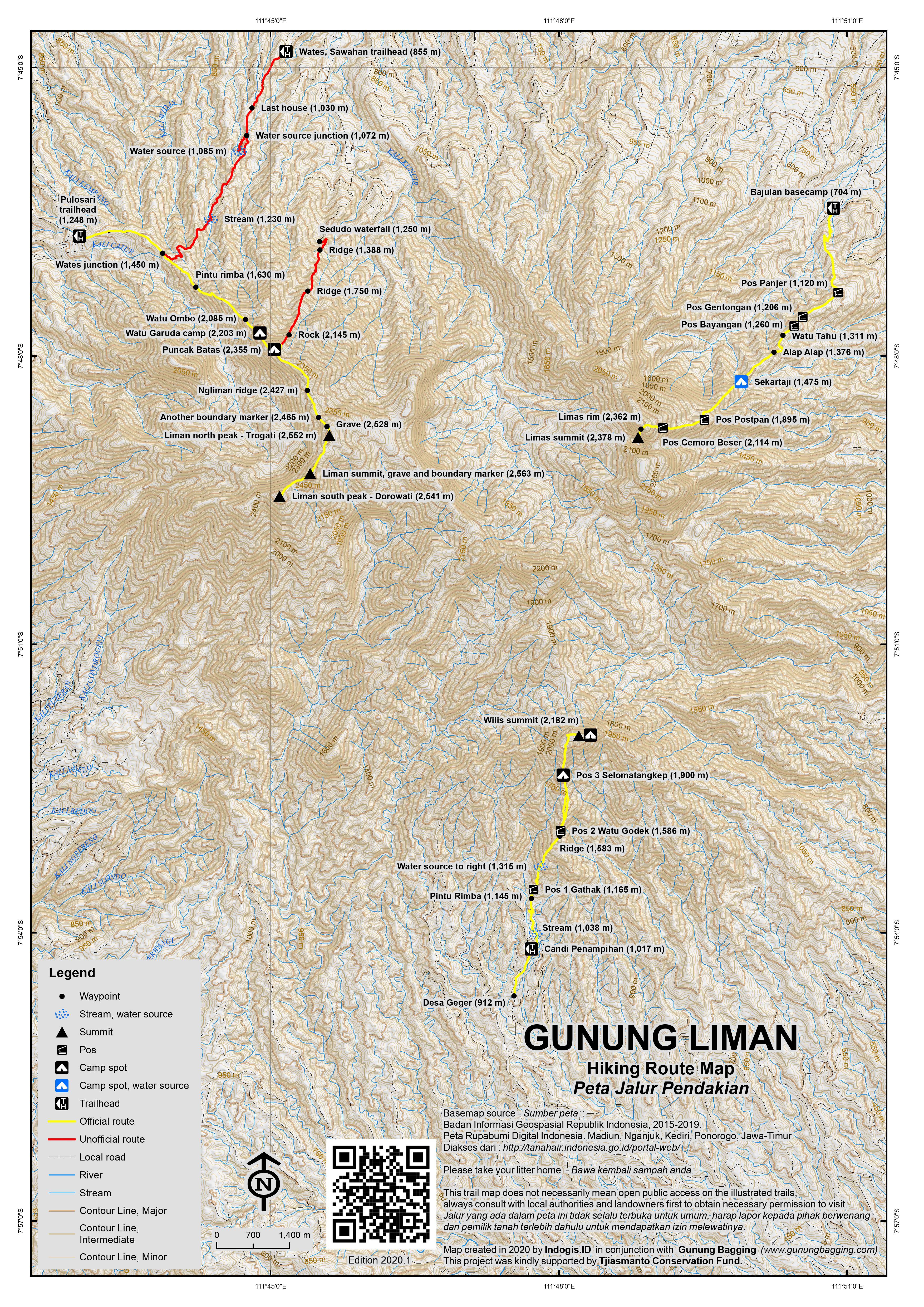
This peak is the highest point of a vast and complex mountain range most commonly-known as Wilis. There are three main peaks, each of which is the highest in one section of the range: Liman (2,563m – the mountain ridge to the west), Limas (2,376m or higher – the eastern mountains) and Wilis (2,182m – the southern mountains) but there are a large number of other peaks with considerable drops between them. Wilis is the most well-known name and Limas is the most often often climbed (from Roro Kuning via Nganjuk, or sometimes from the Kediri side at Besuki.)
Gunung Liman
Liman itself is rarely climbed and unfortunately access is a grey area, although the situation seems to be improving as more local hikers wish to visit. Technically, at least until recently it would appear that the most of the mountain range is closed for ordinary access (unless you are conducting scientific research, for example) and this has been the case since 2006, presumably when a change in the forestry law, or the implementation of a new one, closed access to wild places across Java if they were not on a recognised climbing lane.
For ascents from Kediri or Sedudo waterfall near Nganjuk, you may be able to obtain special permission from KPH in Kediri, but even if you get lucky they are likely to send their staff members on the expedition with you – and charge a considerable price for it. It’s a bizarre and incomprehensible situation given the popularity of hiking in the province and the fact that more hikers means more people visiting the area and hence more revenue for local people. So, you can either get on with it yourself, ignoring the strict rules (which are, or course, ignored by local farmers anyway) or attempt bureaucratic negotiations which are tiresome and often unpleasant. Finding local guides can also be difficult because so few people know the mountain range.
From Sedudo waterall, Nganjuk:
At first glance, the most accessible starting point would appear to be Sedudo. The waterfall is a popular place with local people and is indeed very impressive. It is about one hour by motor vehicle from the friendly and laidback town of Nganjuk via Sawahan. The entrance gates and ticket booth are at an elevation of 930m but the road itself leads all the way to the waterfall itself at 1,250m. From here, steps lead down to the waterfall and a trail leads across to the right along the side of the ridge to the right of the waterfall. This vague and overgrown path is very tiresome to follow in the heat and makes for incredibly slow progress but it does eventually lead up to the top of a ridge (1,388m) which has a reasonable path running along the top of it, used by local farmers. There are good views eastwards to Penanggungan and Arjuno-Welirang in the distance and a small hill in the north, lying north of Nganjuk, labelled Gunung Gede on Google Maps but seemingly known as Gunung Pandan to local people.
From the trail on the ridge, you would be forgiven for thinking that it would be an easy stroll southwards up onto the highest parts of the ridge. After a kilometre or so of steady climbing along a perceivable path, the trail almost entirely disintegrates, at an elevation of about 1,750m. This is perhaps because local farmers do not climb much higher than this and very few people climb this way.
The terrain is very troublesome – steep, sometimes bouldery long grass where you never know just how or where you next step is going to land. Overgrown is an understatement. It is assumed that the terrain is similar for much of the Liman ridge, sadly due to the fact that it is so rarely hiked at the present time and it would be a rather time-consuming expedition to reach the highest point of the range from this route.
From Pulosari, Kare, Madiun:
Better still is to start from the Madiun side at the tiny hamlet of Pulosari (1,248m) near the town of Kare. Local hikers should have no problem if they bring photocopies of their ID cards to the security post at Kempo (900m) but foreigners hardly ever climb this mountain range so eyebrows are likely to be raised and senior security officers and police asked if it is ok for you to proceed. Even with local hikers as guides and photocopies of your passport you should expect to have to wait a couple of hours for clearance.
Motorbikes or 4WD are essential to reach the trailheadf at Pulosari because the plantation track is in poor condition and often muddy during the rainy season. From Pulosari, the trail leads up along a overgrown ridge on which are a couple of cement markers (first is at 1,445m). The best advice that is simple to remember is to ‘stay to the right’ because there is a junction (1,450m) just an hour beyond Pulosari where the trail to Liman leaves the main trail (which continues, flat, into the forest). This is where another less-popular route up from Wates, Sawahan meets the ridge. There is another cement marker at 1,525m. The trees in this area were badly damaged by forest fires in September/October 2012 and so the trail is almost impossible to see at this point.
A little higher up, you reach a field of tall grass (1,600m) through which runs a very clear footpath. 20 minutes beyond this is a small shelter at the entrance to the forest (1,630m). After about 30 minutes ascending in the forest, the trail leads out onto the grassy, overgrown ridge of the mountain (1,730m). Gloves are advisable because this grass can be razor-sharp. Unfortunately the terrain remains like this for much of the rest of the climb, but the frustrating nature of the trail is somewhat balanced by the pleasant views which improve with every metre gained. A decent place to rest is Watu Ombo (2,085) – a jumble of rocks one of which is large and flat – perfect for sitting on. After a total of around 5 hours you will have reached an excellent flat area of short grass perfect for camping (2,203m) just beyond a couple of rocks incluing Watu Garuda – ‘Garuda Rock’. In good weather you can see Lawu to the west and the city of Madiun to the north.
From the camping area it is still about 2 and a half hours to the northern Liman peak (2,552m on Bako maps) and another 1 hour to the grave peak which according to GPS devices is the highest of them all (2,555m on Bako maps but more likely 2,563m as suggested by other sources). A final, southern peak around ten metres lower in elevation (2,541m on Bako) is a further 30-45 minutes so a very early start is essential if you want to check all the likely candidates for the true summit and be back down in Madiun by the end of your second day. The distance is not so great but the terrain remains tough to negotiate for much of the journey and a machete may be helpful.
Just southeast of the camping area is a minor top, Puncak Batas (2,355m), named so because it has a boundary marker at the summit. The trail then drops down a little bit before meeting the vague trail up from Sedudo at a wooden ‘x’ sign (2,345m). Beyond here, heading south, you are now on the Ngliman ridge. The next point of interest is another boundary marker (2,465m) before a small shelter and grave (2,528m), complete with incense sticks and signs that someone stays here from time to time just north of the northern top. From this area you can enjoy views through the trees to the lesser summit of Limas to the east in the direction of Kediri. The northern top (2,560m on GPS, 2,552m on Bako maps) is just ten minutes further and features a small, oval stone structure built into the ground which may or may not be another ancient grave.
From here it is another 1 kilometre southwest as the ridge curves round of hard slogging through seriously overgrown terrain to reach the true peak with a grave and boundary marker on it and finally the southern top which appears to be a bit lower based on both the Bako map and GPS readings.
Very, very few people ever continue beyond the northern top. The middle top (between north and south tops and seemingly the highest) features a small grave of unknown antiquity and another boundary marker. If you want to be sure you have bagged the highest point, best continue to the southern peak, as there is not much difference in elevation between the north top, the middle grave top and the southern top. The mountain ridge descends to a col where lots of wild pig (‘babi hutan’) droppings can be seen. Pick your way through the dense undergrowth and ascend up the steep, final section of the climb to the southernmost peak over 2,500m of this remote mountain area.
The southern top features a pine tree into which someone has inscribed ‘GI 2010’. Be careful here because there are lots of holes between rotten tree stumps. To have made it this far – onto one of the most remote and least-visited high points of Java – you deserve a serious pat on the back. Enjoy the views before slogging all the way back to camp and back down to Pulosari (reached in 7 hours total by fast hikers) or spend another night back at the Watu Garuda camp area.
Once out of the forest on the way down towards Pulosari, make sure you do not simply follow the good path through the long grass. You need to take a slight left and head down the scrubby, partially-burnt ridge on which are the couple of cement posts. Making this mistake could leave you in a very remote area far from Pulosari so take extra special care at this point.
In the future, an approach from Pundak Kulon to the south may be an attractive option, although this is a more remote area and no signs of a trail leading up from that side were spotted during a December 2012 trip to the highest tops.
Wates, Sawahan route
The other route mentioned above which is not popular yet and could be overgrown starts in the hamlet of Wates (855m) to the north of the range. You can actually get motorbikes as far as the last house (1,030m). From here, a local guide is necessary. Follow the vague trail south and fill up water bottles at the stream just to the west of the trail (1,085m). Another stream is passed (1,230m) before finally meeting the main trail in from Pulosari on the ridge at 1,450m.
Gunung Limas (c2,376m with a prominence of around 552m)
The most popular trek on the range is to the top of Gunung Limas, which is to the eastern side of the highest ridges of the range and is a thoroughly worthwhile trek with good views. Although Gunung Limas is sometimes climbed from near Kediri, the primary route starts at the village of Bajulan (704m) near Roro Kuning waterfall, which is less than one hour by motorbike or car from Nganjuk.
From the very friendly basecamp, the route leads along a plantation track through corn and cassava fields before entering forest scrub (895m). It then passes Pos Panjer (1,120m) which is a very tiny clearing in the scrub which you should have reached after an hour or so. Look out for interesting wildlife in this area as we saw a critically-endangered slow loris.
The next Pos is Pos Gentongan (1,206m) and then an un-named Pos sometimes called Pos Bayangan (1,260m). Watu Tahu (1,311m) soon follows and this is not a ‘stone of knowledge’ as you might hope but rather a rock shaped a bit like a cube of tahu (tofu)! After this you gain a ridge at another small pos that can fit a tent or two small ones (1,350m). From here, the vegetation becomes less as the low-growing grass dominates, meaning excellent views from this slightly undulating ridge. Remember suncream!
Pos Alap Alap (1,376m) is reached (after around a total of 2 hours from the start) and in less than 30 minutes you will be at the favoured camping spot called Pos Sekartaji (1,475m). This is an area of ridge with attractive boulders and two ancient stone structures, one of which now only features the very base). Down to the right near the bamboo is a water source which explains the popularity of the spot for camping.
Gunung Limas is still rather quiet compared to most mountains in Java but you will almost certainly meet local students on weekends. This means a trail which is clear enough to follow and with sufficient but non-intrusive signage and very little litter.
Those that you meet at Sekartaji will probably be surprised if you have made it up there in 2 and a half hours, but unless you are carrying camping equipment there is no reason why fit hikers cannot be there in under 3 hours. Allow a further 2.5 to 3 hours to reach the summit ridge and around 4-5 hours total for the descent.
Sekartaji is a pleasant spot for sunrise, with views to Arjuno-Welirang and Gunung Butak, but even higher up is even better, with a shapely triangular top on the neighbouring ridge to the north and a large rock on the neighbouring ridge to the south. Because of the lack of trees the views are wonderful, especially early in the morning. Gunung Pandan (897m) can be seen below to the north of Nganjuk.
Beyond Sekartaji, Pos Pospan (1,895m) is reached after an hour of steep hiking, and apparently marks the meeting point with the less well-used trail up from the Kediri side. Pos Cemoro Beser (2,114m) comes next and is clump of tall pine trees. Just after these is a tough section with a simple rope where you need to pull yourself up very steep terrain of ten metres or so. The ridge around here is narrow in places and the trail rather slippery too, so be very careful.
After Cemoro Beser be sure to look out for lutung which are known to live in this area. Finally, after a total of 5-6 hours (or 2.5-3 from Sekartaji) you will find yourself at what local hikers regard as the summit. There is a flag, some signs and a simple pillar of some sort. There is also partial remains of a ancient stone carving and in clear weather some great views over to the Liman ridge about 5 kilometres to the west.
True peakbaggers will probably see that there is higher ground along the ridge to the left and indeed the highest GPS reading we got (around 2,378m compared to 2,368m for the signs) was about 100 metres away (less than 5 minutes) where the views to Liman are even clearer. In between the two you might spot the remains of what might have once been a trig pillar and may have been the source for the 2,368m figure on the Bakosurtanal map of the area.
According to the Bakosurtanal map, the highest peak in this part of the range is actually about 1 kilometre south of the usual summit with signs, through thick undergrowth. It is apparently 2,402m in elevation but is not named on the map. If anyone has visited with a GPS then let us know as a confirmed height of around 2,402m would mean this ‘Limas Selatan’ peak has a prominence of around 578m and ought to be the real target for hikers here.
Gunung Wilis
Gunung Wilis (2,182m) may give its name to the range as a whole but is only the third highest peak of the range (and not even third if you count the various tops near Limas and Liman and both Gunung Lombok and Gunung Keber between them in the very inaccessible heart of the range).
However it is probably the third most prominent and certainly represents the main target for hikers exploring the remote southern side.
The nearest large town with a railway station is Tulungagung from where it is about an hour to the starting point in Geger, Desa Sendang. This village is around 900 metres above sea level and so it’s no surprise that cabbage is a common crop here. There are also small areas of tea plantation higher up.
The trail itself is slowly growing in popularity but is not yet as overloaded as most other peaks in Java and and has much to recommend it. The exact location of the trailhead is at Candi Penampihan (1,017m), a Hindu relic of the ancient Mataram era that is well looked-after by locals. Note that there is another temple called Candi Sekar on the Bakosurtanal map. This is several kilometres further east in Nglurup which is at a similar elevation and also has tea plantations.
The trail to the peak takes around 4 hours or less for most keen hikers, passing vegetable fields before Pintu Rimba (1,145m), Pos 1 Gathak (1,165m), water source junction (1,315m), and most notably Pos 2 Watu Godek (1,586m). Watu Godek is an impressive notched rock with some Hindu grafitti and also the point at which a minor trail leads down to the left to Lawean waterfall.
Next is Pos 3 Selomatangkep (1,900m) which is probably the best Pos to pitch a tent or two, although most continue to the grassy summit ridge. After Pos 3, the vegetation becomes less dense and then there is a section absolutely full of orchids. Shortly after you find yourself in waste-deep grasses and with a view of the other peaks in the range to the north. The trail curves round along the summit ridge to the right and the true Wilis peak, marked with some local hiking club signs and a collection of stones.
This is a great place to camp and there is enough room for tens of tents, though given it takes less than 3 hours back down the hike can easily be accomplished in a single day if you start early enough.
There are leeches on this side of the range so come prepared if hiking during the rainy season. About 1 kilometre due east of the summit is the second highest in this area – Gunung Slurup (2,048m) according to Bakosurtanal.
Additional short hike: Anyone staying in the Kediri area after hiking Liman or Limas might want to hike Gunung Budheg (483m) just a few kilometres south of the town of Tulungagung. Up a steep, well-used muddy trail it takes just one hour to reach the first summit (463m) which is just beyond a telecommunications tower. From the first top are great views to the Liman-Wilis range and to the higher peak which is only about 20 metres higher. Both tops are on near-vertical cliffs and are presumably an ancient volcanic plug of some sort.
It takes just ten minutes to hike between the two tops but watch out for aggressive monkeys. The summit is popular at weekends with local students camping and/or photographing the sunset or sunrise.
Bagging information by Daniel Quinn (January 2013), Budheg information added November 2017, Limas information added February 2018, Wilis information updated August 2020. The August 2020 expedition was kindly supported by Tjiasmanto Conservation Fund.
Trail Map
For a high quality PDF version of this and other trail maps, please download from our Trail Maps page.
Practicalities
- Getting there: For domestic flights from or to East Java, such as the airports in Surabaya, Malang and Banyuwangi, we recommend Baolau. One or two express trains between Jakarta and Malang/Surabaya/Jombang call at Nganjuk and Tulungagung and many call at Madiun. For Sedudo from Nganjuk there are angkots to Pasar Sawahan (Rp 7,000) from where you can get an ojek to Sedudo waterfall. For Pulosari you really need locals with motorbikes or a 4WD.
- Guides and GPS Tracks: Want a PDF version for your phone? Looking for a guide? Need GPS tracks and waypoints? Gunung Liman information pack can be downloaded here.
- Trip planning assistance: Would you like Gunung Bagging to personally help you in arranging your whole trip? Please contact us here.
- Permits: You may wish to speak to KPH (Kesatuan Pemangku Hutan) in Kediri but if you start from Pulosari near Kare you may find things easier to arrange with local security and police officials. Register with locals for the Limas and Wilis trails.
- Water sources: Available at Sedudo waterfall and in two places low down the trail on the Wates route but none available higher up or on the more popular Pulosari route. Take more than you need for what is a very wild hike. Available at Sekartaji (1,475m) on the trail to Limas peak. Available off the trail at 1,315m on the Wilis trail.
- Accommodation: Try the Booking.com map above or use this link to search for suitable hotels, homestays, resorts and apartments for your trip.
- We recommend Safety Wing as travel insurance for overseas travellers and tourists hiking up to elevations not exceeding 4500 metres.
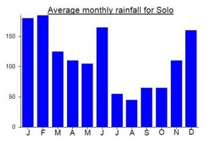
Local Average Monthly Rainfall (mm):
Location
Click on the blue arrow ![]() (top right) to see your current location on the map
(top right) to see your current location on the map
Origins and Meaning
Elephant Mountain. Liman is the high Javanese (krama) word for “elephant”. Elephants used to be fairly plentiful in Java but they have now died out completely on the island. Nevertheless there are several place names that recall the presence of elephants, including Gunung Liman which (presumably) is so called because it has the big, solid, greyish appearance of an elephant. Gunung Wilis = Dark Green Mountain. In Javanese wilis means “dark green”, especially dark burnished green like the shiny dark metallic green on the wings of a beetle. (George Quinn, 2011)
Another international group visited Liman today. The weight of evidence certainly seems to support the middle peak being the highest, as expected and as shown on the Bakosurtanal map. But only by a metre or two, as the northern peak (Trogati) is higher than shown on the Bakosurtanal map, almost as high as the middle peak. The south-western peak (Dorowati) seems to be third-highest.
do you have instagram ??
I had an absolutely beautiful hike up Liman recently. The ecology and geography is totally different to all the other hikes I’ve done in Java. The volcano went extinct hundreds (or more) of years ago, so it’s much more like rugged rolling landscape. There’s some coffee plantations and some thick forest, but mostly is this spaced out forest over long grass. And it’s deserted. We saw zero humans who were not in our group on the whole hike, and couldn’t even hear any mosques after Pintu Rimba. Natural Java is a totally awesome experience.
We went on the yellow trail to Liman marked above. Note that basically on this trail, ‘pos’ mean there might be some kind of sign but also might not, and there’s probably space for at least one tent. We camped for the night around the spot marked Ngliman Ridge, which is definitely a recommendable place. OK protection from the wind and a lovely flat-ish area to hang out, while still being quite high up and therefore close to the peak and having great views. You get a great view out over the cliffs that you end up walking along the top of as you’re hitting the three peaks the next day. And, magically, we even saw what might have been an actual meteor fall in the valley between the campsite and Puncak Dorowati (literally it was visually in front of the peak and I can think of no other explanation for what it would have been).
On timing, from basecamp to Pulosari trailhead on ojek took us 30 mins, then hiking from there to that campsite took us 5 hours including short breaks. The next morning, from the campsite to North Peak / Trogati only took 25 mins. Pak Hamzah no longer seems to live there, but there is a hut available for pilgrims to use and lots of evidence of what seems like a relatively steady flow of them (incense, cigarette, and coffee offerings, the whole area is quite tidy, etc). We then pushed on to South Peak / Dorowati, which is marked and has a sitting area and great views, even though the trail is overgrown. I would have totally missed the peak in the middle – not really any signage around it and didn’t feel taller than the other two (though could have been – I didn’t have my own means of measurement) – and the guides were adamant that Trogati is the highest one. But the walk amongst the three afforded great views of Lawu, Arjuno, Semeru, and many other parts of the Wilis area. We were back at Ngliman Ridge camp about 4 hours and 15 mins after we set off, including lots of time chilling, snacking, and photographing at the peaks.
On logistics, we heard lots of horror stories, but frankly it was pretty easy and friendly. It seems that access is still technically difficult, but there is a basecamp that you can just contact to arrange everything (IG: kare_ecoadventure), and they were so friendly. Pak Johan took us back to his house to meet his family afterwards. Simaksi was Rp 50K for foreigners (I think Rp 30K for Indonesians). The guide later told me that technically any visitor (both WNI and WNA) should register with polsek before entering the area, but if you go with the basecamp they look the other way. The base camp buildings have only been finished being built in the past year, and like half the town turned out to greet us when we arrived. I think they don’t get many hikers. Bang Yoga asked me how I knew about the trail and when I said Gunung Bagging, he proudly told me that he had been Dan Quinn’s guide, many years ago. When asked, the estimates for how many groups hike the mountain, the answers I got ranged from “up to 2 per week” to “usually at least 1 every two months”.
Intriguingly, they told me that there’s a peak they called Puncak Lombok, in the middle of the Wilis area, which is not the highest but is definitely the least-visited. Looking at the map, it seems to be the 4th area that’s over 2000m (after Liman, Limas, and Wilis). They offered to guide me there next time I have 4-5 days to spare, and I may take them up on it next year. My guide told me there are 86 named peaks in the Wilis area, and the area is huge, so I do feel like there would be tons to explore if I go back.
Rob W hiked Liman recently from the south on an overgrown trail. Day-hike. You can read his trip report on Peakbagger here: https://www.peakbagger.com/climber/ascent.aspx?aid=2061727
https://www.tribunnews.com/regional/2020/09/03/pendaki-berencana-kembali-kunjungi-pria-yang-tinggal-di-puncak-gunung-wilis-ingin-beri-bantuan
Interesting article. It seems the highest peak is now known as Trogati. But is this a new name with no historical link, or an ancient name that very few knew about until recently. Would be interesting to trace the development of the name.
Pak Hamzah has chosen a very peaceful spot in which to live for 2.5 years!
My plans to hike Gunung Tebak in Lampung once again fell through so I had to quickly choose something to do as a final summer break hike. The Liman / Wilis range has always been one of my favourites, as it is quite unlike the well-trodden higher peaks of Java that arguably see too many people on them nowadays. This mountain remains wild and is large enough for it to not be understood well as a whole by many people. Some folk on the Nganjuk side will know Limas, folk down near Tulungagung will know Wilis, but they often won’t have heard of the peaks on the other side of the range. The ancient sites scattered around the range adds to the timeless atmosphere and from the tops there always seems to be a distant ridge with cloud swirling around it beautifully. Other mountains have changed in recent years but this range is still wild.
I got the train to Tulungagung where my guide met me and within an hour we were up at Geger, still before first light. There was a large building housing an elaborately painted car with Javanese mythology on it – perhaps Nyai Roro Kidul’s car. I got changed into my hiking gear in there (in the building, not in the car!)
A bit higher up the road at a dead end is a little tea plantation and the impressive Candi Penampihan which is the trailhead. Nice to hear that gamelan performances still happen in these villages.
The first section of trail is just through plantations, so it’s open, but was a little cloudy for us. Once in the forest the views are limited until near the very top. We were up in just 3 hours 30 min and there were a few small groups already up there, for the Indonesian Independence Day celebrations. A very atmospheric summit as was expected, a bit more cloud than was hoped for, but still a transcendental trek as is the norm on this particular massif!
On our way down we met at least another 150 hikers. Sounds like a lot, and for Gunung Wilis it certainly is, perhaps the most it will have ever seen up until now. But it’s nothing compared to the 15,000 or so who hiked up Gunung Bawakaraeng in South Sulawesi for Independence Day. Anyway I was happy to have hiked it on the 16th rather than the 17th!
Just did Wilis as per your email excellent recommendations, thank you very much. We were completely alone during the entire hike (up and back down in about 7h). Everything is still exactly as you described. We were a little bit unlucky to be in the clouds at the top, so no views. But wonderfully peaceful hike and very little garbage. Those using shirts got a few leaches, but no big deal. Thank you!
Now that we all have so much time stuck indoors, I have been going over the data for all Java peaks in preparation for trail maps which are being made this year.
There is still a fair bit of confusion over which is the highest peak of Liman. There are three contenders…. the north peak, the middle grave and boundary marker peak, and the southern peak. Previously, I had thought it was either the north or the south peak, but looking at bonus GPS data and re-examining the Bako map, it now seems that the middle grave peak is likely to be the highest.
According to the Bako map: North peak – 2,552m, Grave and boundary peak – 2,555m, South peak – 2,541m.
According to GPS devices…. all quite similar but the middle one quite likely to be the true summit.
Back in 2012, we hiked across them all, thinking the southernmost might be the highest from looking at Google Earth, and also just as a precaution it made sense to encourage folk to trudge all the way there to be sure. It still probably is wise for those who want to be 100% sure, but my money is now on the middle grave peak!
Bako’s highest figure is 2,555m. But we have kept 2,563m because GPS readings were over 2,560m on several occasions so 2,563m sounds reasonable. But Bako are hopefully right on the relative height of the different 3 tops.
Ultimately, a new expensive survey would be required to be 100% sure, or else improved technology that will mean SRTM data is much more accurate (which could well be on its way in the next few years).
This just in from Norwegian Petter, who is finishing off ascents of all the Ultra-prominent peaks in Java:
“Liman was very nice, quite a different experience,
a very long and nice ridge walk.
I took many and quite careful GPS readings with my pretty
new Garmin. All three tops are close enough in elevation
that normal GPS cannot decide. Differential GPS is likely
needed. However, just looking at trends when moving between
the three summits, I am not convinced that the south peak
is higher. In fact, since the north peak currently clearly
is the official summit, I would tend to leave it that way, but
point out that there are two “challengers” and one must for the
time being climb all three to be certain. “
This Liman / Ngliman / Wilis / Limas mountain range really is one of the wildest and most magical in Java. Partly because it is not popular enough for there to be too many other hikers or too much litter, and partly because it is dotted with ancient sites and has some brilliant views from its many ridges.
I decided to give Limas a try as a dayhike (perfectly possible if you set out early, ideally pre-dawn for the best photos) yesterday as part of a mad trip from Jakarta as follows…. in order to get to Nganjuk with enough time to hike on the Saturday morning before sunrise, I flew Batik Air Halim to Semarang. Stormy weather with the plane seemingly surrounded by lightning shirtly after take-off but perfectly on time, so much so that I managed a couple of beers at the On On Pub near Semarang’s Poncol station.
From Tawang station, got the Bangunkarta train which is one of the few that uses the Semarang-Solo line (probably picturesque in daylight), arriving at Nganjuk at 0145. Bang Ekta and his friend Mas Heru were waiting. After a quick coffee near the station, we set off and were at the basecamp in around 40 minutes, on a road which passes by a prominent Sudirman statue. I always knew this was going to be a risk, weather-wise, in February but we got lucky with stars clearly visibly above us.
I found the trail delightful, with sufficient arrows to make getting lost quite difficult. We actually saw a very rare Javan slow loris near Pos Panjer – quite something. Once on the grassy ridge on the way to Sekartaji it was obvious the views would be brilliant once the sun had risen. Friends were waiting at Sekartaji with more coffee. We were there in just 2 hours and 20 minutes, much quicker than the trail maps at basecamp made by students from UGM Yogya and others might suggest. Would love to know more about any research done on the candis or other ancient monuments on this mountain, of which there are reportedly several.
The sun rose behind Gunung Butak in the east and we continued onwards up the now steeper grassy slopes. Another 2 hours and 30 minutes and I was at the top. Spotted a lutung on the right at an elevation of around 2,200m. The views over to Liman are quite magical early in the morning and it is great to see Liman from Limas after having seen Limas fro Liman back in 2012.
Back down would have taken just 4 hours for me, but the others were having issues with cramp, the weather closed in a bit and the mud path is rather slippery in places, especially higher up where it has just the wrong consistency for grip!
I waited down at basecamp – a very friendly place with cheap coffee and wifi available. The number for this basecamp is 0852 3283 0246. I recommend you give this trail a try if you haven’t done so before. Heru finally arrived and said Ekta needed help getting down, so serious was his cramp, so someone set off on a motorbike to the edge of the plantation to help him down. I had no idea how long this would take so was rather worried as I had a train back to Jakarta to catch and work the following morning! Was about to arrange an ojek independently when Ekta arrived. So made it back down to Nganjuk in plenty of tie and bought some Nasi Pecel for the train. A second night spent on the Bangunkarta…. and then into work straight away pretty much! Absolutely worth it for the views on this great trail – how nice to do a new trek on an island where you feel like you’ve almost done everything worth doing!
beautiful place, i hope someday can visit it
thank you for the information, the scenery is good, the hike is a fun ride and also very dangerous
what is owned by the three peaks?
where did you start the climb and how long did it take you, is it easy to find some guides???
Thanks in advance
Running out of significant new hiking options in Java, I decided to give the small (483m according to my GPS) but impressive-looking Gunung Budheg a try this weekend. A decent excuse to visit Tulungagung and the south coast nearby.
This meant getting my favourite train from Jakarta (the Gajayana which runs all the way to Malang via Jogja, Solo, Kediri and Blitar) on Friday after work, arriving in Tulungagung just before 7am and then returning on the Sunday at 1546 due to arrive back at Gambir at 0427 Monday morning (fingers crossed!)
Well, the views of the ocean were great from my ojek ride down to Pantai Popoh but the beach itself was a great disappointment…. more like a muddy construction site than a place to walk on the sand!
Gunung Budheg was much better. I had initially tried to find a guide at the Consina shop but they seemed to think I could get one at 4am at the entrance. Ojek from the train station to Budheg was rp50,000 but you could probably bargain down a little.
Entrance to Gn Budheg (very well-known and well-signposted) was just rp3,000 and the trail looked obvious enough for me to go without a guide. Plenty of locals up there already anyway.
The trail passes through pleasant terraces with a couple of swings and becaks for locals to sit around on. Then there’s a huge sign spelling out the name of the mountain. After that the trail gets very slippery and steep and most will be very glad of the rope tied to trees.
The views of swirling mist in the valleys and the gentle distant sounds of gamelan instruments prior to dawn made up for the low cloud covering Liman-Wilis.
Do take care as the drops from both tops are sheer. In the middle is a third viewpoint with a little statue of some sort. Seems to be a popular area to pitch a tent on Saturday night.
Back down took an hour and was perhaps harder than ascending. No ojeks easily found so I wandered back to the main road, got some Nasi Pecel and hopped into an angkot /minivan. Friendly locals.
Perhaps not worthy of its own page but definitely recommended as a short hike to a great early morning viewpoint.
Just went down from Liman from Sedudo trail with a successfully climbed southern peak. Its was a rather tough hike due to some bureaucratic obstacles, I asked around warungs and security where is a start of the trail, but its seemed nobody knews it or more likely they intentionaly did not want to reveal it due to security reason. So i decided to search the trail by chance by ascending a left ridge from the waterfall. Its was very exhausting task which involved a rock scrambling and wading the bushes, but fortunately the vegetation was not so thick so finally I managed to get to the top of the ridge. Was no any path visible there, but I just simply walk between the pine trees until encountered a vertical unclimbable rocks. Then its decided to descend to the nearby flowing river and to ascend to the another paralel ridgeto the right, which looked more obviesly leading to the peak. Its slope was incredibly steep and rocky, but after all I arrived to the top of that ridge and the trail was just there, reasonably clear. I was too tired, anyway still proceeded further up. The terrain was almost completely grassy and the trail often hidden under the grass, but it was in good condition anyway, despite that is quite rare used from this side. During a climb there was no a single flat place for the tend, so I had to get as high as a main Liman ridge where there must be a junction to Pulosari route, but I did not noticed it. On the northern top there is any sign of the Liman peak, only a indonesian flag put in the tree and a hole, presumably used to accumulate a water in the rainy season.
After northern and southern peak is a rather hard terrain through thick grasses and fallen trunks which took me about 1 and a half hour including the time to enjoy a views which was really stunning and more open than from the northern peak. From this side there was very few evidence of someone presence.
The return way took me just about 3 and half hours down to Sedudo
I guess this G Wilis range peak is one of the least hiked peak in Java. Perhaps only second to G Suket (2900m), the peak east of G Raung. Although quite high it is rarely hiked.
One more thing, what is so special about it? The difficulties, the view, the people, the forest, the waterfall, the leeches ……?
Actually we didn’t meet any leeches. I particularly enjoyed how wild the mountain was – quite an expedition to reach the highest top.
Congratulation Dan. I was born and grew up in Nganjuk and have been admiring G Wilis range since long time ago. But never got the convincing information so far how to get to the 2563m peak. Also not from a fellow hiker from Nganjuk. Still longing to reach the peak from Sedudo someday.
I have to admit I didn’t think this one would be successful. I’d had serious problems both with legal access and the terrain itself in the past and, having already climbed Ringgit and Argopuro, I thought maybe I should let this one go and come back another time. However, my feet were fine after one day of rest in Madiun and local hikers Madat Yosa and Chandra seemed very keen to help myself and Roman attempt to reach both of the highest tops from Pulosari. The rest day was spent devouring the local vegetarian-friendly dish of Nasi Pecel.
The lads picked us up with their motorbikes just after 5am and we were off up to Pulosari. It took about 90 minutes to reach the security checkpoint in the plantations at Kempo where the officers were rather bemused to find foreigners wishing to climb the mountain. To cut a long story short we had to wait for a police van to arrive from Kare to ask us what our plan was and then wait again for an officer to drive up all the way from Madiun. This amounted to about 3 hours and I was close to giving up due to the lack of remaining daylight hours needed to get up to camp or beyond. We were also doubtful that they would let us proceed but amazingly the officer from Madiun was very pleasant and let us on our way almost immediately (I would have to collect my KITAS the following day from the police office in Kare). He probably wondered why he had be called out all the way up here just to give the go ahead for some hikers to go hiking. Bizarre.
We left the motorbikes with the very pleasant villagers at Pulosari (another 25 minutes of so up the rough plantation tracks) and finally set off hiking at around 10.30am or so. Myself and Roman were well ahead of the pack who were perhaps confused as to how a beer-bellied Englishman and senior Swiss gent could ascend so fast through such difficult, unpleasant and tiresome undergrowth terrain!
We took a rest at Watu Ombo, about 30 minutes before reaching the Watu Garuda area where we decided to camp rather than lug all our tent gear higher up the trail and risk camping separately from the others. The sunset was very pleasant with decent views of Gunung Lawu peeking through the clouds and the lights of Madiun in the distance. At around 2,200m the temperature was fairly pleasant too.
The plan was to get up at 2.30am for a 3am departure in order to reach both summits and make it back down to Madiun the same evening. We finally set off at about 4am but two hikers decided to turn back on Puncak Batas and a further hiker left us at the southern peak. It was just the four of us who battled onwards along the densely-vegetated and overgrown ridges at a pace of about 1km per hour to make it to the marginally higher southern top for 8am. An exhausting but successful hike.
After the obligatory summit photos myself and Roman set off back down the trail with a plan to meet everyone back at camp which we would leave around 12 noon in order to try to make it back to Madiun before dark. As it turned out, the local hikers were totally knackered and wanted to spend a bit more time (i.e one more night) on the mountain before descending. So myself and Roman descended alone.
We got a bit lost once out of the forest section but with the invaluable help of my GPS we managed to get back on track at the vague section that could cause serious confusion to any hikers without enough waypoints.
Our feet were soaked and sore by the time we made it down to Pulosari but local farmer lads gave us a ride down into Kare where I collected my KITAS. The police agreed to drive us back to the hotel in Madiun (Rp 200,000) rather than us having to sit on more motorbikes with our backpacks. More Nasi Pecel was devoured and our feet left to recover. The following day I boarded the Bangunkarta night train back to Jakarta and spent a rather subdued New Year’s Eve asking the staff in the dining car why it was now no longer possible to drink, smoke and do dangdut karaoke onboard the kereta api.
Look forward to hearing of any other hikers who attempt this rather mysterious, special mountain.
Well, as far as I could tell, the ‘officials’ who came on this particular hike did have a disliking or a grudge towards foreigners and did view the ‘bule’ as nothing more than an ATM. Unpleasant in any country and in any situation of that sort for anyone. However, I would say it is still pretty rare in Indonesia and in most countries. I was unable to have much conversation with the ‘officials’ as they appeared dismissive and uninterested in communication except to dismiss the information on a perfectly-reliable Bakosurtanal map. There were there for one thing – uang. That is fair enough, no problem with that, but at least have a little respect for others on the hike regardless of the colour of their skin or the fatness of their wallets. The locals hikers were very pleasant but the trip itself was a poorly-organised shambles entirely because of the selfishness of the ‘officials’ and despite the best efforts of a couple of local hikers to make it a success.
Funny situation when it’s considered selfish to only pay for yourself but acceptable to get someone else to pay for everything for you and your mates. However, if the payer offers to do so then fine, as I would have done had the ‘officials’ been a little more pleasant.
Putting to one side the issue of who pays for what, there is a more important issue which is to do with basic, fundamental human decency that goes beyond any local custom and applies (or should apply) to all of humanity. Unfortunately, said ‘officials’ showed none of this whatsoever and proceeded to take advantage of the situation to the fullest extent possible, little care for anyone but themselves.
I’m not quite sure why you are so concerned, Jack. After all, you weren’t even there (as far as I know) so why the need to defend people you’ve never met and in circumstances you were not involved in? Whenever a criticism is aired in Indonesia, people jump to defend whatever it is that is being criticised. Trouble is, criticisms are sometimes appropriate and it is through them that progress can be made.
This hike was quite some time ago now and although it stays in my memory as one of the least enjoyable it doesn’t particularly bother me and even serves as a rather humorous anecdote (funny how that often happens over time to some of the trips that seemed really annoying at the time). I hope to head out that way again this year for an attempt from a different direction.
Well the impression that I got from your original comment is that as if everyone here detests and ready to take advantage of foreigners, especially white people. I’m from Kediri, and frankly I was offended with the comment.
But now that you made it clear that it was only the ‘officials’ that got you all upset, well, what can I say, sometimes you met bad people..
@DAN, if you ask someone or group of people to go along with you on a trip, it’s *the* custom that you take care of the bill. So it has lesser to do with the fact that you’re a foreigner. Besides, it’s not like prices are very expensive anyway. Noodle is peasant food. How much did you pay for the whole group, $5, $10? C’mon let’s not be too tight about it.
There’s nothing tight about paying well over a million rupiah to be ‘allowed’ to climb a mountain with a group of people some of whom clearly detest foreigners and whose only goal is extracting as much cash as they can without mugging you. If I hadn’t have needed to ask them to come along to make the ascent ‘quasi-legal’, believe me I wouldn’t have bothered with them at all.
Thankfully this is the exception rather than the norm and there are another couple of potential routes up Liman which are worth checking out.
As you said, the climb is quasi legal, and that’s what you paid the one million for, not for some kind of professional hiking escort service. But that’s not the point. I was just pointing out the custom on who are supposed to pay the bill.
Not sure if this is a local custom or Javanese custom, but when you’re traveling in a group, it is considered selfish or at least awkward to pay just for oneself and leave. On the other hand, it is too costly for one of them to pay for everyone. That’s why the wealthier is supposed to know this and take care of it before anyone else. Yeah, paying time is always an awkward situation here.
Sorry that you’ve had unpleasing experience here, but to say that people detest foreigners is very strong words and I quite resent that. As I said they only had instant noodle which is far away from proper food. The one that got away with one million is probably different people (most likely their boss).
Hi Handjono
Thanks for the information but I would expect a route 10km to the east to be a lot further from Liman – maybe they’re thinking of Limas???
I’m going to try from Kare (via Madiun) in April or May or June.
Do you know the Rorokuning approach/route? Rorokuning is a waterfall some 10 km east of Sedudo. Some hikers say this route leads to G Liman (2563m).
Some good news – there is a route up to the Liman ridge from Kare near Madiun. The bad news is it is quite a mission – 2 days up, one day back down, according to a local hiker. He has not climbed since 1999 so the terrain may be even tougher now. I hope to try again, from this approach, in July or August.
Just got back from an Xmas attempt on this utter swine of a mountain! As if the forestry bureacracy is not enough of a hindrance, the terrain makes for incredibly slow going, certainly from the Sedudo side. A very pleasant friend of a friend helped arrange a quasi-legal trip up this route (involving throwing lots of tree seeds onto the grassy ridges) but, other than a few nice views, it was a totally joyless trip.
I got the Bangunkarta night train from Jakarta to Jombang which stops at Nganjuk, to meet a really nice guy at the station who took us up to Sedudo.
In the end, there were no less than 6 people with me, some ‘offically’, some local hikers tagging along, but as per usual in this country, it’s the white person who always pays the bill, even if you’re already paying! It took us ages to get started from the waterfall warungs (after I was expected to pay for a breakfast of noodles and kopi jahe for everyone, on top of the agreed fee – some people really do think money grows on trees where ‘bule’ come from). The weather was very good for December but once on the ridges spent a lot of time waiting whilst others threw tree seeds around – a considerable delay to progress and somewhat offensive and lacking in manners given that I had paid 1 million rupiah for this hike with the expressed intention of reaching the highest point of the range – an important piece of information which hadn’t been passed on to the Kediri chaps, who questioned the accuracy of both Bakosurtanal maps and GPS information from Google Earth! Some of the names on the Bako maps could well be inaccurate but it’s amusing how the peak called ‘Liman’ or whatever your target is called happens to be the nearest and less high one! It’s times like these that guides seem to be more of a hindrance than a help. I would have been better off – and happier – on my own!
As I wrote above, once you’re on the path on the ridge to the right of the waterfall it is pretty pleasant but by 1,750m the terrain was some of the worst I have come across. After 6 hours (2 hours of waiting around, 4 hours of hiking) I looked at my GPS which told us we were just 1.3km from the starting point and still almost 4km from the highest peak (in a straight line). The clouds had also descended by this time. We were at just 1,900m and I decided we should just turn round and descend as the chances of getting to our destination was out of the question in the time we had remaining on this sort of terrain. It could be that the top ridge has a better quality of trail on it – I hope to try from the Madiun (Kare) side one day.
Perhaps I was being lazy to turn back, but the decision of a hotel bed in Nganjuk or a boring, tiresome and unecessary evening halfway to the highest peak with some people – who were quite clearly not interested in what the point of the trip was – seemed obvious! I just couldn’t be bothered by this point. We headed back down to the warungs near the waterfall (under 2 hours) and, after the Kediri lads made one last attempt to utilise whatever was left in the bule’s wallet, headed back into Nganjuk for a rest.
It a real shame that there is no more done to encourage access to places such as Liman – it is pretty obvious that if there was a well-used trail it would be a brlliant hike with phenomenal views of other peaks in East Java and would be of great benefit to all. You have to wonder just what purpose a forestry/National Park law serves if it means limiting access to the outdoors in this way. Liman is one to file alongside Ijen-Merapi and Baluran n East Java and Salak 2 and Halimun in West Java – all peaks officially closed to the general public for mystifying reasons.