
Facts
- Elevation: 3,088 m (10,131 ft)
- Prominence: 2,745 m
- Ribu category:
 Sangat Tinggi
 - Province:
 Jawa Timur (East Java)
 - Coordinates: -7.9644, 113.5664
- Rating:

 (27 votes) Add your rating
 Loading...
 - Other names: Argapura, Argopura, Argapuro
- World Ribus ID: 69016
Photos


Bagging It!
The Argopuro mountain complex offers one of the longest and most isolated treks in Java with incredible scenery to match. Above the agricultural land (corn, cassava, tobacco, coffee, cocoa), at about 1,200m, the track enters tall, often moss/lichen/epiphyte-covered, lower-montane forest. At higher altitudes (above about 1,800m), casuarina (Casuarina junghuhniana) dominates the upper-montane slopes; this specie is especially resistant to fires that are quite common. Extensive “button-grass” meadows occur in depressions. Edelweiss (Anaphalis javanica) occurs in the sub-alpine zone around 2,600m and above. Many local hikers spend 4-6 days making the traverse and the 3-day trip is about a short as you can realistically make it.
The ruins of an ancient Hindu temple on Rengganis peak, named after Princess Rengganis who supposedly built the temple possibly as early as the 12th century, make for a mystical experience. The highest peak is Argopuro (3,088m) adjacent to Rengganis (3,059m). The track passes by the beautiful, secluded Danau Taman Hidup (Living Garden Lake) (1,957m).
The Rengganis/Argopuro peaks can be approached from either the towns of Baderan to the north-east or Bermi to the west. The Baderan ascent is more gradual although longer. This description starts at Baderan and finishes at Bermi. Guides/porters can be arranged and permits obtained from the Forestry Office, Baderan (at the end of the asphalt road), for which copies of passport/ID are essential.
Day 1: The trek from the Baderan Forestry Office (780m) to an old Dutch airstrip (2,215m) is about 14 kms and takes about 8-9 hours. The track climbs steadily through agricultural land, Protected Forest and into the National Park. White, numbered, posts mark the track every one hundred metres, with zero being the edge of the Protected Forest. Villagers ride motorbikes up this track as far as the Protected Forest. Two unreliable water sources are at elevations of 1,830m and 2,165m (at post No. 19) before the trail leads up to a mini ‘puncak’ (near post No. 32 at 2,261m) before descending a hundred metres or so. The first large meadow reached (‘Alun-alun Kecil’ about post No. 40 – 2,150m) offers an excellent lunch stop. Not long after this meadow is another, larger meadow known as Alun-alun Besar (at post No. 63 – 2,320m). The trail then leads over a small bridge (post No. 73 – 2,271m) before leading for another 45 minutes and descending slightly to Cikasur (2,215m).
The Airstrip at Cikasur (post No. 92 – flowing water) lies on an extensive meadow where deer, pigs, peafowl, pheasants and jungle fowl are always heard and often seen. The Dutch administration apparently built this airstrip around 1919 for the visit of Dutch Royalty to promote conservation and management of the area; another report informs that it served to establish a ranch and meat factory. In 1943, the Dutch sabotaged the air strip to prevent its use by Japanese forces. There is a small shelter on the edge of the meadow and fresh water salad can be collected in the nearby stream (eaten raw or cooked).
Day 2: The trek from the Airstrip to Rengganis peak is about 13 kms and takes about 7-8 hours. The track continues up through casuarina forest interspersed with open meadows with some views eastwards to Gunung Raung, until descending into a valley with a small hut (Cisentor – flowing water, 2,445m) at post No. 142 (about 3 hours). The white markers abruptly end higher up in the forest at no. 150 for no apparent reason! The trail is a little vague at this point at it crosses a dry riverbed (‘sungai kering’, 2,625m) before leading up through Edelweiss. The area was badly affected by forest fires in September/October 2012 but it is hoped the area will have been rejuvenated before long. Water is available again in a small, hidden spring at Rawa Embik (rawa: marsh; embik: bleat of a goat, 2,755m) about 2 hours from Cisentor. From this point, no more sure water is available until Danau Taman Hidup or until reaching Bermi.
The saddle between the Rengganis and Argopuro peaks is reached after about another 2 hours. Here, the track divides into three directions. The “left-hand” track ascends to Rengganis with the ruins of the Hindu temple (good camping – about 20 minutes – no water) and views to the east of the Ijen mountain complex on the eastern tip of Java and Gunung Agung in Bali. The “right-hand” track ascends to Argopuro, the highest peak (just under 30 minutes each way) where there is a cairn/grave but, unfortunately, casuarina trees at the summit obscure the view. Danau Taman Hidup, the north coast of Java and Madura and the Ijen mountain complex can be seen through the trees. Bakosurtanal maps list the peak as just 3,072m in elevation but this seems an underestimate based on GPS readings.
Day 3: the descent (in total, about 2,100m) to Bermi (990m) can be made by two routes. A longer, but steadier, descent is made by returning to Cisentor and circumnavigating Gunung Rengganis to the south and west via Taman Kering (2,470m) (about 8-9 hours). The alternate, more direct but steeper and less often used, descent is via the “middle” track on the saddle between the Rengganis/Argopuro peaks (about 7-8 hours). The two routes meet at a small stream (water not guaranteed even during the rainy season) after about 3 hours via the shorter route. Our preference is the shorter route which, although quite steep in places, offers great views of the mountains and valleys to the south and west including Semeru. Danau Taman Hidup, complete with a dilapidated wooden pier, is reached after another 2 hours at around 1,957m. Bermi is a further 2-3 hours down the track, which is quite steep and badly-eroded in parts. The final track passes through agro-forestry plantations before reaching Bermi (also sometimes written ‘Bremi’). Irregular angkots run down to the main road at Pajarakan (Rp 15,000, just under one hour) from where you can catch a bus to your next destination.
Bagging information by Nick Hughes, updated by Dan Quinn (January 2013).
Trail Map

For a high quality PDF version of this and other trail maps, please download from our Trail Maps page.
Practicalities
- Getting there: For domestic flights from or to East Java, such as the airports in Surabaya, Malang and Banyuwangi, we recommend Baolau. The nearest airport is Surabaya from where it takes several hours to reach the trailhead by car. The smaller Banyuwangi airport is an alternative option and may save you an hour or so. Regular buses travel along the northern coast road. Alight at Besuki and take an ojek (Rp 40,000) up to Baderan.
- Guides and GPS Tracks: Want a PDF version for your phone? Looking for a guide? Need GPS tracks and waypoints? Gunung Argopuro information pack can be downloaded here.
- Trip planning assistance: Would you like Gunung Bagging to personally help you in arranging your whole trip? Please contact us here.
- Permits: Guides/porters can be arranged and permits obtained in both Bermi and Baderan. In 2019, locals pay Rp20,000 per day (Rp30,000 weekends and national holidays) and foreigners pay a very steep Rp250,000 per day (Rp375,000 weekends and national holidays).
- Water sources: In the Baderan-Bermi direction, reliable sources available at Water source 1, Water source 2, Cikasur, Cisentor, Rawa Embik and Taman Hidup. Note that Water source / Mata Air 1 & 2 are not always reliable during the dry season.
- Accommodation: Try the Booking.com map above or use this link to search for suitable hotels, homestays, resorts and apartments for your trip.
- We recommend Safety Wing as travel insurance for overseas travellers and tourists hiking up to elevations not exceeding 4500 metres.
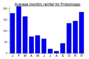
Local Average Monthly Rainfall (mm):
Location
Click on the blue arrow ![]() (top right) to see your current location on the map
(top right) to see your current location on the map
Origins and Meaning
From the Javanese words ‘arga’ meaning ‘hill/mountain’ and ‘pura’ meaning ‘shrine’. The ruins of a Hindu temple are at the top and the mountain is an important pilgrimage site.
Did the Argopuro traverse from Baderan to Bermi last Fri-Sun with a guide and porter through ClimbIndonesia (same company I did Raung with last year). Covered 42km over 3 days 2 nights, with 20 of it first day. Flew to Surabaya on Thursday and then driver took us to Baderan basecamp where we slept the night. On Friday morning took an ojek from Baderan base camp up to around 1800m. First day hiked from there to camp at Rawa Embrik. Stunning landscape the whole way, forested in some parts and then beautiful open meadows in other parts, and then lovely streams and views. Second day hiked from Rawa Embrik up to summit Rengganis and Argopuro, and then across the ridge to Hyang and down the shorter route to second night campsite at danau Taman Hidup. Beautiful lake, sunrise the next morning was stunning. 3rd day hiking was an easy and quick descent down to Bermi, only took a couple of hours despite ojeks having dug out the trail in many parts. Then the driver we’d arranged took me back to Surabaya for flight home to Jakarta.
This hike is all about the landscape over the whole hike, rather than just the summit of Argopuro, which compared to many other volcano summits is nothing special (no crater to look, just basically the top of a hill and minimal views. As others say, the area is surprisingly quiet for a Java mountain – I saw other people from time to time, but particularly over the first 2 days didn’t come across many. Taman Hidup campsite was busier, but there is plenty of room. The section from Baderan up to Argopuro is stunning, a really special place. We walked all the way to Bermi basecamp, but most others seemed to take ojeks from somewhere below the lake.
Many people do this traverse over 4 days 3 nights, or as I did over 3 days 2 nights. A fast hiker with good endurance could do it over 2 days 1 night, camping at Sabana Lonceng (2973m) on the saddle between Rengganis and Argopuro. But that would be 2 quite big days, with the 1st day involving around 24km and 1100m ascent, and the second day another 18km with 2000m descent. I normally hike fast and smash out most volcanos as day hikes, but this is a mountain area worth spending some time relaxing on. Saw a few trail runners too who were just doing a day run with minimal gear.
July 2023. Used Rob Woodall’s route from the west, but by hiring local ojek drivers to get to 1850 m near Taman Hidup. Only 3 hours from there to the summit, and 5 hours round trip.
Rob Woodall is doing a number of peaks in Indonesia at present and amazingly did Argopuro as a day-hike from the Bermi side. I remember when we did it it was 3 days (admittedly for the traverse) and most locals took 4 or 5.
You can read his trip report on Peakbagger here: https://www.peakbagger.com/climber/ascent.aspx?aid=2060693
Dear sir,you can try hiking to Kali pedati hidden waterfall.there ia very Special waterfall of Mt.Argopuro and still naturaly
More info or guiding please contact me Iwan erfanto 085232600118 or email iwanerfanto@gmail.com
Anyone interested going to Argopuro between 6-10 September? I’ve been to Argopuro in 2008 and would love to hike this mountain again this year. September would be a good time because while it’s still the dry season, the green peafowl’s mating season might have started.
My pace is moderate and if possible I will do the hike without a porter 🙂
Hey Mier,
If you are up to it I want to use the rob wood wall route next week
, Hit me up
I went to Argopuro a week ago. It seems to be now quite common to go by ojek from Badwran to mata air 1. And actually there is no reason not to use that service (120000 IDR). I started in the early afternoon so that I went only to Cikasur. Starting earlier it would be better to continue to Cisentor or even Rawa Embik. Cikasur is full of animal life (wild boars, peacocks, lutung groups nearby). That part is very cold with temperatures that can fall below zero during the night (it did when I was there). Cikasur is one of the most beautiful spots of the tour.
The second day I went to the two summits and I continued to the lake Taman hidup. I didnt see anybody from the starting point until the lake. The way down from the summits to the lake was longer than I expected (nearly three hours and a half). And there is no sign that indicates the trail.
The whole tour can be done in two days starting early in the morning from mata air 1 and going until Rawa Embik at least. But it is more recommendable to take three days.
As a mountain Argopuro is not really interesting; the hike is rather interesting as a kind of highland trekking. And it is really a quiet trek without many people (nobody at all in my case until reaching the lake) even if it is not remote at all.
Reliable water sources are Cikasur (slightly warm thermal water with high mineral content), Cisentor (high mineral content), Rawa Embik (by far the best water on the trail), and lake Taman hidup (turbid water with a high load of organic material).
Unfortunately, foreigners pay now 375000 IDR per day (12.5 times what Indonesians pay). This should not be supported. So, please, foreigners, avoid this mountain! Anyway as a mountain it is not really interesting. Better go to Semeru or Raung, which are much more attractive mountains.
Argopuro. How could I forget it?
Dense big old towering trees, steep trek to climb with both hands and feet, flat terrain on the savannah, wet forest covered in moss, big rotten logs lying across the trails that force you either to stoop or stretch your legs, blessing rain and wet shoes as a bonus. It is really an “all in one” mountain. Quite hardcore I’d say. Back from the mountain, I just slept and ate and drank for the next two days.
I did the Argopuro trek a couple of weeks ago.
I arrived to Pos Baduran from besuki by ojek (40.000Rp) and after register at the Pos, the ranger asked me if i wanted a lift for the first 3km (40.000Rp) and as it was already noon I accepted.
I arrived to Cikasur and spent the night there.
On day 2 I walked to Cisentor ealy in the morning. It is an easy and short walk. After I set up my tent still wet from the night, I took just a small backpack with water, snacks and camera and walked to the summit of Argopuro and Rengganis.
I was back at Cisentor quite early and i decided to pack and walk to Danau Taman Hidup. BE CAREFUL!!! as this part of the trek is not just descent, there are 2,5km quite steep and hard if not in a good physical condition. It took me 4 hours to complete this part of the trek. The path is overgrown and also uncomfortable to walk, don’t underestimate it.
On day 3 I just walked from Danau Hidup to Kurcil, this is quite an easy walk.
My track log is in wikiloc.com ready to download and load into your gps. I used some waypoints from gunungbagging.com.
Please keep the paths and camps clean, bring a 500ml empty bottle with you to use as a garbage bin. All your food wraps, even the part you tear off, cigarette butts, tissue after going to “toilet”, batteries, etc can fit in there… you would be surprised. And avoid cans and other food “containers” that you cannot put inside the bottle unless you take them back with you. Please avoid increasing the amount of litter in Indonesia’s beautiful Nature.
Selamat sore Pak Quinn .. hehee .. kita bertemu di cikasur . remember me ?
Dan must have started from Baderan and descended to Bremi. Reaching Baderan is better from Besuki. In Baderan the BKSDA Chief will arrange the porter for you. The BKSDA also has a modest guest house next to the office. Logistics can be collected from a warung nearby, owned by the retired BKSDA Chief.
Be careful with the jelatang (fire leaves) around Sicentor a little higher. The leaf stings you like a bee and the itch stayed for some hours.
If you are a durian lover, both Baderan and Bremi have very delicious durians. The season is March – April.
That would make the most sense, Marcus. The Mutiara Timur executive class train runs from Surabaya to Banyuwangi once every 12 hours and calls at Probolinggo. Best get a bus down to Besuki rather than ojek all the way.
Actually I worked my way there from further east, but I wouldn’t recommend it unless you have other places you want to visit over that way first….
Banyuglugur is between Paiton and Besuki…closer to Paiton.
Hi Dan,
Congratulations on another bagging! A couple of questions: how did you travel from Jakarta? Did you fly/take the train to Probolinggo first, and then ojek to Banyuglugur? Where is Banyuglugur?
M
Three of us decided to climb this mountain over the Christmas holidays. Pak Suryadi sent down ojeks to collect two of us at Banyuglugur (Rp 30,000 each, we gave them 50,000 each for what is quite a journey) at 5am on Day 1. Unfortunately the morning was nearly overshadowed by unpleasantness when we were asked to pay Rp600,000 ‘logistic’ fee on top of the already agreed Rp 100,000 per day per porter and enough for food and local transport back round on the final day. I said there was no way we would be paying it as no Indonesian would ever pay anything like that amount. You may wish to pay such a sum if you have a large group and require a guide in addition to your porters but don’t be bullied into what is by no means obligatory. So, finally, we ended up paying the Rp6,000 that everyone else pays in order to hike in this area.
The porters soon proved to be some of toughest, fittest chaps in Indonesia – marching ahead leaving us sweating miles behind. Indeed, these blokes could probably do the whole trek in a single day if they really wanted to. They were also ingenious, skilled at constructing shelters in a matter of minutes and starting a fire with soaking wet wood (the secret it to take a bit of rubber to help things along).
We heard lots of peacocks at Cikasur but didn’t see any. There was a lot of birdlife down at Cisentor – two I managed to photograph have been identified as Indigo Flycatcher and Plaintive Cuckoo.
Finally making it up to the higher slopes on the afternoon of the second day it was raining when we made the short detour to ‘bag’ the highest peak itself, an atmospheric little top of cairns lurking in forest.
The weather had been pretty wet as expected but early morning on the third day at the top of Rengganis was perfect for the excellent view of Gunung Raung in the distance to the east. We could even hear it rumble at around 6am (it has been very active as of late). Early morning is also the best time to explore the fascinating ruins of Rengganis temple. There is a distinct smell of sulphur in places which suggests there is still some limited volcanic activity in the area.
The trek down to Bremi was knee-destroying but well worth it for the views of Danau Taman Hidup and Semeru from the short cut which skirts round close to one of the deep summit craters.
Finally back down at the main road after 3 days on this magical mountain, it was on to Probolinggo before getting the train round to Madiun to make a second attempt on another wild peak – Liman.
Had planned to climb Argopuro at the end of October but apparently there are still forest fires affecting the mountains – or potentially affecting the mountains. Either way, many of the giants of East Java are out of bounds right now with the prolonged dry season causing all sorts of chaos. Arjuno-Welirang was particularly badly affected… http://www.thejakartaglobe.com/news/forest-fires-continue-to-ravage-east-and-central-java/547433
So, check before you head out this month, especially for peaks in the drier East Java.
Baderan to “Airstrip” (locals called it Sikasur (=the matrass), there are 2 water sources. Mata-Air-1 is 3 hours from Baderan and then another hour to Mata-Air-2. Mata-Air-1 is at the left side of the trek and Mata-Air-2 on the right. Both springs are a few minutes below.
Before Mata-Air-2 you can see on your right some kilometers away 3 tall waterfalls.
At Sikasur small river you can eat the selada air (nasturtium microphyllum). The vegetable is edible both raw and boiled. Extremely delicious to accompany your lunch or early dinner.
The small stream of Sicentor also has plenty of selada air. Two hours from Sicentor, towards Bremi, there is another small stream of Aengkenik (little water). Small camp site for 3 tents. Then 8 hours hike to Tamanhidup Lake.
Around Tamanhidup you are not allowed to scream unless you want to invite bad weather.
There are fishes in the Tamanhidup. So you could fish over there.
Exiting the woods, if you are lucky you would meet the villagers on their motorbikes. They collect grass for their cows. They can take you to Bremi, saving you 1 hour of walking in the confusing area of the plantation.
A good article on Argopuro in the Jakarta Post by Phil Rich, December 2010….
http://www.thejakartapost.com/news/2010/11/12/hiking-java%E2%80%99s-forgotten-mountain-argopuro.html
I went there yesterday. Took from Bremi than start trek to Taman Hidup (6pm-2am). Argopuro has longest trek in Java. I also recorded its track in my gps.