
Facts
- Elevation: 2,868 m (9,409 ft)
- Prominence: 1,673 m
- Ribu category:
 Tinggi Sedang
 - Province:
 Jawa Timur (East Java)
 - Coordinates: -7.9553, 112.4651
- Rating:

 (20 votes) Add your rating
 Loading...
 - Other names: Also spelt ‘Bhutak’
- World Ribus ID: 69061
Photos


Bagging It!
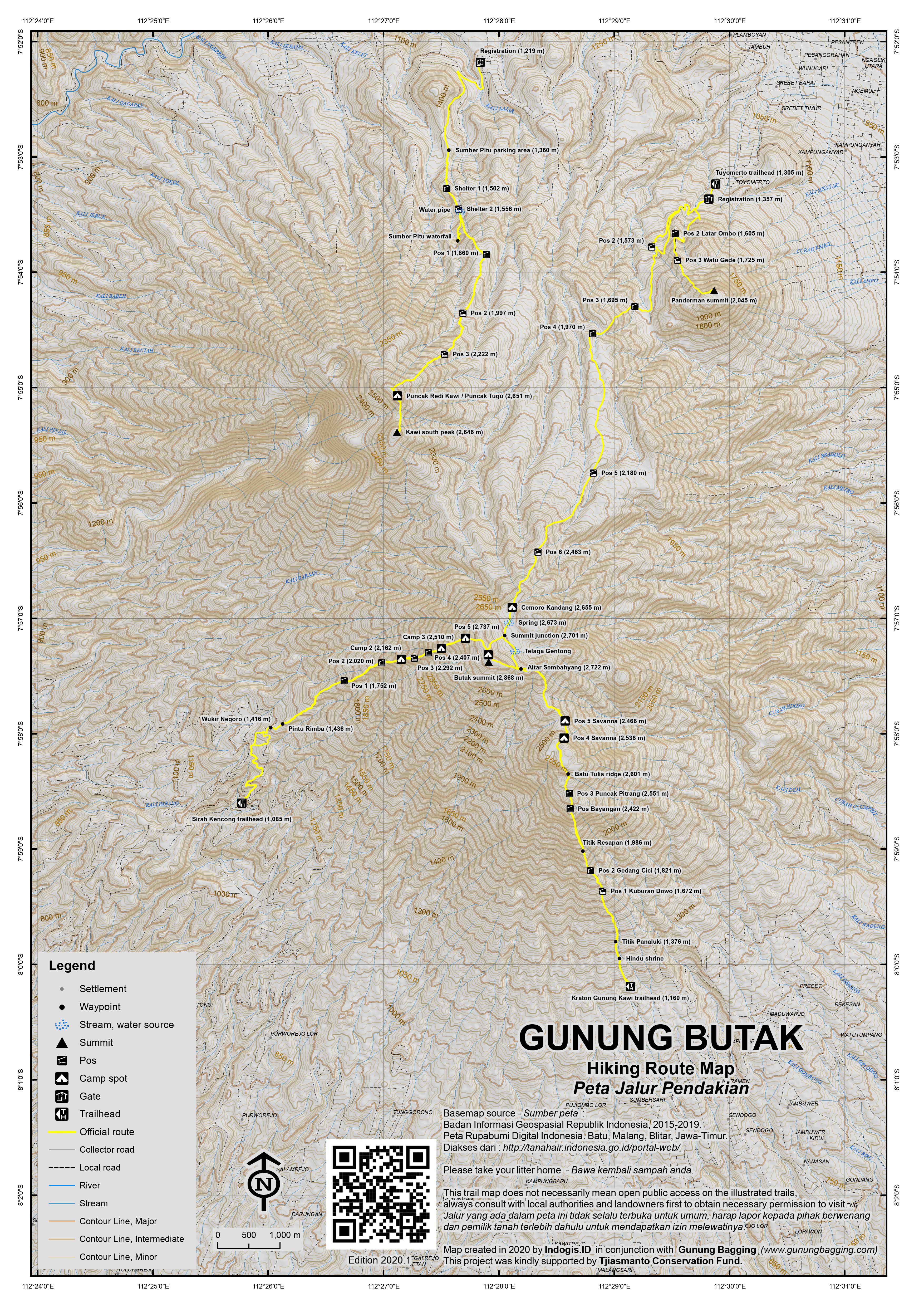
Gunung Butak is the highest mountain of a large range west of Malang, East Java. As it is under 3,000m in elevation, it is less popular than other, higher peaks in the region (many of which can be seen from the top). There is a delightful grassy meadow near the summit called Cemoro Kandang which is perfect for camping and the views at the top are spectacular.
Tuyomerto, Batu route
There are three main starting points for this Ribu and the most popular and easily reached is Tuyomerto village near Batu, Malang. Up until 2015 or so, the mountain was known only to hiking enthusiasts and a few local villagers – indeed, most locals had never heard of Butak and it was necessary to say ‘alun-alun’ or ‘savanna’ (alternative names for Cemoro Kandang) or ‘Gunung Kawi’ (a lower peak in the range but also the name of the range as a whole).
As of 2017 things have changed dramatically with a considerable increase in the number of people climbing this mountain and the smaller Gunung Panderman which is part of the same range but much lower at just 2,045m. The trail up Butak is no longer overgrown, and there are signs for both Panderman and Gunung Butak (spelt ‘Bhutak’ on the signs here for some unknown reason). From Batu, take an ojek to Kampung Tuyomerto (1,305m), which takes about 15 minutes, and follow the road as far up as you can go.
The old basecamp is gone but there is an attractive new wooden building (1,357m) above Tuyomerto village where hikers can purchase very affordable entrance tickets, find guides and porters, and leave their motorbikes overnight. There are even a couple of warungs to purchase snacks and drinks.
Pak Budi remains the best guide and can organise other villagers as porters. A guide can take you up and down in one long day (start early!) or a guide and porters will take you one-way and carry your gear to the camping area at Cemoro Kandang / Alun-alun / Savanna – you then carry your own gear down the next day. You can also hike at night in time for the sunrise and then straight back down – this means no need for camping gear but then again you won’t be able to savour the atmosphere properly unless you do camp up there.
From the new wooden building above Tuyomerto, it takes approximately 5 to 6 hours to reach the large grassy camping area known as Cemoro Kandang (or ‘alun-alun’ / ‘savanna’) (2,670 m) and the hike is almost 10 km following a fairly modest gradient. It takes about 3.5 to 4.5 hours to come down the same way. There are several places on the trail where it is possible to camp, but none are anywhere near as pleasant as Cemoro Kandang.
From the base camp, the climb through the cabbage fields and other agriculture to Pos 2 (1,573 m) takes about 45 minutes. From Pos 2 you continue up a valley in degraded/secondary forest before the steepest section of the hike up to Pos 4 (1,970 m), which takes about 1 hour. After this climb, the trail has a very nice gentle gradient via Pos 5 (2,180m), which mean you can hike at a good speed. Look out for edible physalis plants (‘ciplukan’ fruits) growing by the trail at an elevation of around 2,200, – 2,400m.
After another 3 hours you should reach Pos 6 (2,463m), faster if the trail is clear. The route to the alun-alun – known as Cemoro Kandang (2,670 m) – and camping area is much clearer from here, and should take no more than 2 hours. The views in good weather are lovely from here as you walk beneath tall trees and see Semeru and Arjuno-Welirang in the distance. As the trail skirts round the mountain, you will see a peak to the right (west north west) which is part of the same range as Butak but difficult to reach from here. It is called Gunung Kawi and has two peaks over 2,600m in elevation. In clear conditions, to the left of Kawi is Gunung Liman and Gunung Lawu in the far distance, and then the pyramid-like rocky summit of fiery Gunung Kelud in the foreground. Looking north, you may see the large forested range called Anjasmoro which lies west of Arjuno-Welirang and has an unusual-shaped peak.
Once you have arrived at Cemoro Kandang (2,670m), look for a suitable flat area to pitch your tent (preferably away from the main path to minimise noise from other hikers at night). In some areas the grass is very clumpy. There is an excellent source of drinking water from a spring with a pipe, and beyond the spring, further south, is a brilliant view to the summit of Java’s highest peak Semeru.
The highest point is a 30-minute climb up to the top of the ridge that surrounds the alun-alun and in good conditions you can see Arjuno, Semeru, Liman and Lawu in the far distance. This ridge is presumably the remains of an ancient volcanic crater wall, though these days there is no obvious volcanic activity here. In previous years it was not always easy to find the trail to the true summit, but as of 2017 there is a signpost for Gn Butak about 250m south of the spring (follow the path on the right) and at the point at which you have a very clear view of Semeru to the east. In good weather, you may even be able to see the large stone cairn and flagpole at the summit from Cemoro Kandang itself.
After admiring the panorama of the giants of East Java, it is 20-25 minutes back down to Cemoro Kandang from the summit, unless of course you wish to camp on the summit ridge which is certainly large enough for 10 or more tents. Although higher up, the night-time temperature at the summit may not actually drop as low as down in the valley, and if you want more solitude and the finest views at sunrise then camping here is a great idea, but note there is no water at the very top. The Bakosurtanal map suggests the peaks is only 2,862m high but GPS data seems to be in favour of 2,868m.
Kraton Gunung Kawi, Kepanjen route
Whilst most hikers return the same way to Tuyomerto (in under 4 hours for fast hikers), there are at least two other routes worth considering if time is not an issue. Firstly, a trail continues south from Cemoro Kandang to an ancient well and some interesting ancient grave sites and small caves. Note that if you have camped on the summit, you can simply follow the pleasant ridge down and meet the trail about 200 metres east of Altar Sembahyang (2,722m) which is a very impressive and ancient religious site on the ridge.
From the junction (2,717m), the trail drops down into a valley that used to be difficult to navigate but in 2020 seems more frequently-used and sadly suffered a forest fire in 2019. There are markers tied to trees every hundred metres or so so it is fairly easy to keep on the track. The col, or lowest point, is a beautiful grassy meadow (Pos 5 Savanna – 2,466m) which has great views and would make a brilliant camping spot.
After Pos 5, the trail leads up the face of another peak in the range. This is labelled on the Bakosurtanal map as Gunung Pitrang but is better-known as Batu Tulis. In actual fact, there are several minor peaks within this side-peak, so naming can be a little confusing! After a little ascent, a second meadow is reached, between two minor hills. This is Pos 4 Savanna (2,536m) and, despite having no water source, would also make a decent camp spot. The trail leads through the grassy area and then veers up to the left onto Pitrang / Batu Tulis, with a considerable drop on the right side of the trail.
This takes a little more time than expected, weaving left and right through undergrowth, but eventually you will reach a minor top with a small pile of stones and probably a sign for Puncak Batu Tulis. This spot on the main trail is simply the Batu Tulis ridge (2,601m on GPS), so if you want to visit the actual Batu Tulis peak itself (recommended) then you need to follow the obvious side-path leading east for ten minutes or so along the ridge to an ancient pile of stones rather similar to the huge cairn at the very summit of Butak.
Batu Tulis is clearly a site of considerable significance to local people with an interest in keeping the old traditions alive. Incense sticks are left here, along with various offerings that call to mind Java’s Hindu-Buddhist past which remains not far under the surface in many Javan mountain areas.
Puncak Batu Tulis is somewhere around 2,603 – 2610m according to GPS and appears to be the highest point in the Pitrang / Batu Tulis area. However, the Bakosurtanal map suggests only 2,593m with the overgrown and flatter summit you have just skirted round from Pos 4 a tiny bit higher at over 2,600m.
After enjoying this important spot, in order to continue your trek, whether ascending or descending, it is recommended to head back along the ridge to the main trail at the smaller pile of stones.
Continuing downwards towards Kraton Gunung Kawi, the trail heads roughly southeast to another minor top (Pos 3 – confusingly labelled Puncak Pitrang, 2,551m) where there is enough space for 3 or 4 small tents. After this point, the trail enters thicker forest.
There are a couple of Pos Bayangan signs (notably at 2,422m) and it is alleged that there is a water source to the east of the trail (left if you are descending) but you would need a very experienced guide to find it. Titik Resapan (1,986m), Pos 2 Gedang Cici (1,821m) and Pos 1 Kuburan Dowo (1,672m) follow in quick succession but none would make especially good camping spots.
As the name might suggest, there is a small and presumably ancient grave at Pos 1. Continuing on the descent, you will finally reach Titik Panaluki (1,376m) which is where plantation fields are reached. A little further down is a small Hindu shrine just to the side of the track.
Soon after this you will find yourself at the Kraton Gunung Kawi car park (roughly 1,160m elevation) which is a place where people go to pray for good luck and so on. There are several warungs where you can enjoy a snack and drink and also a public toilet block where you can wash and change. Note that there is no basecamp here and most folk are here to visit the temples.
Although this is a slightly shorter trail than Tuyomerto, it is much less frequently used, liable to be more overgrown, harder to find water, and it feels longer, and takes more time. However, it is the most interesting of the three main trails on what is a very interesting mountain indeed. Allow around 5-6 hours to get down to Kraton Gunung Kawi from Butak summit.
Ascending from this side would take more time, especially if carrying camping gear, so an early start is absolutely essential. Note that some say that you must first visit the local spiritual guardian of the mountain (‘juru kunci’) before hiking from here and that you should only hike up on even days of the calendar (Javanese calendar?) To what extent this is followed in reality is unclear but if you descend by this route then you shouldn’t need to worry about it.
Sirah Kencong, Blitar route
The mountain can also be climbed from the west in a very pleasant and friendly ecotourism village called Sirah Kencong (roughly 1,085m). It is in the middle of a tea plantation and there is at least one ancient Hindu temple here (Candi Sirah Kencong). This spot is best reached via Blitar (about 75 minutes by car) or Wlingi if coming by train.
This trail actually leads directly up to the summit ridge rather than via Cemoro Kandang. It is slowly growing in popularity but many come here to cycle or camp on the higher reaches of the tea plantations. The trail has several junctions near the start, and almost all of them need a right turn before you reach Wukir Negoro (1,416m), which is a large flat spot ideal for camping.
Just two minutes further on is Pintu Rimba (1,436m) which is another good camping spot offering great views over the valley to Gunung Kelud in the west. As might be expected from the name, this is where the trail enters forest.
Sadly, since 2019 forest fires here, there isn’t much forest left at present and it will take a few years to recover. For now, this trail is steep, dusty and hot. No spot between Pos 1 and Pos 5 is especially great or especially flat and there is no water source. The trail passes Pos 1 (1,752m) which is fairly pleasant, then Pos Bayangan (1,991m), Pos 2 (2,020m), Pos Bayangan 2 (2,176m), Pos 3 (2,292m), Pos 4 (2,407m), and Pos 5 (2,737m).
Pos 5 is lovely and has enough flat space for several tents. You may well see lutung in this area too. But why camp here when you are less than half an hour from the Butak summit ridge itself?
All in all it takes between 5 and 7 hours to reach the summit from Sirah Kencong and probably 4-6 on the descent. For the ascent, much depends on if you are carrying camping equipment and what the weather is like. It is hoped that the forest here will regenerate soon because with a bit less dust and a bit more shade it would be a lovely way to experience a different side of the range, best done in conjunction with another route in the form of a traverse.
Gunung Kawi (2,651m) from Pujon
Gunung Kawi itself is a much less well-frequented peak around 4 kilometres north/north-west of the top of Gunung Butak. It has a steep, presumably ancient crater wall to the west and two summits within 700 metres of each other.
Whereas in previous years the mountain was known only to a few local spiritual pilgrims wanting to pray at the summit, in 2020 the trail from near Pujon Kidul (1,219m) is open to hikers and there is a registration procedure and friendly local guides available. If you are looking for a quieter hike with superb views, then Gunung Kawi is very much recommended.
The actual starting point is at the parking area (1,360m) for Sumber Pitu waterfall, which is 2 or 3 kilometres along a bumpy tracks from Pujon Kidul. If you need to walk in, allow an extra hour, but most waterfall visitors take their bikes to the parking area. If camping on the mountain, best leave your motorbikes down in Pujon Kidul and take ojeks to the parking spot (allow 15-20 minutes).
If you meet other visitors in this area, chances are they will be visiting Sumber Pitu waterfall, which is less than one hour’s hike from the parking area and well worth a quick detour on the way down if you have an extra half an hour or so. From the parking area, follow the signs for Sumber Pitu / Sumber 7. The trail crosses a small stream (1,370m) before leading up beyond the edge of the plantation (1,500m) to a very pleasant shelter (1,502m) with a roof where you can sit and rest and enjoy the views back down towards Pujon and the Anjasmoro range beyond.
A second shelter (1,556m) is soon reached, and just beyond this is a crucial junction where the waterfall trail continues on the right, but the Gunung Kawi trail leads up the ridge on a clearly much less well-trodden path. This junction (1,570m) has a water pipe and is the last reliable source of good drinking water.
Further up, the trail enters forest, providing hikers with some very welcome shade and cooler air. This is short-lived however, and sun cream is advised. The trail passes the first of several danger signs (1,814m) before flattening out for a while and turning slightly to the left (east) and a very important junction (1,832m) with an old, disused trail.
On the ascent, make sure you turn right and make a mental note of this spot so that you do not simply follow the older trail straight down on your descent. Just above this important junction is Pos 1 (1,860m) which is another nice, shady spot. A second danger sign follows (1,930m) and then there are some good views over towards Panderman peak.
Like Pos 1, Pos 2 (1997m) is marked with a sign. From here, the trail becomes steeper as it leads via Pos 3 (2,222m) which in 2020 does not have a sign due to the devastating forest fires in 2019. The trail is perfectly obvious from this point, and the views get better and better and you get higher up and can look down to Pujon and Batu. There are also lots of edelweiss plants growing on the higher slopes.
The next obvious natural landmark is a pleasant rock (2,524m) on the ridge below the summit. You may be able to spot an Indonesian flag or two tied to the trees at the summit. The summit ridge is reached near a small marker stone (2,634m) and from here it is just two minutes to the northern top of Gunung Kawi. You should be at the top in a total of 4-5 hours depending on how many rests you have had.
As you will see, this northern top has two buildings on it. Firstly, a stone shelter with a roof which houses an ancient grave and has sufficient space for a small group to sleep in without the need to bring tents. There is also a water butt here for collecting rainwater, so you can usually use this once boiled for cooking. This stone building is several decades old.
A second, more recent building is the musholla, right next to the stone building, constructed in 2015. Behind them both is a small area which looks as though it was used for growing plants in the past. There is also plenty of space for camping.
This northern top is 2,651m (known as both Puncak Tugu Kawi and Puncak Redi Kawi) and the rather misleading Bakosurtanal figure of 2,622m is for a lower point a little further down on the ridge to the north. The southern top, seen clearly from the shelter, is 2,639m (possibly called Puncak Bantengan) according to the Bakosurtanal map but 2,646m on GPS, so only a few metres lower.
To reach the southern top from Puncak Tugu takes around 15-20 minutes one-way and is worthwhile in good weather. Follow the ridge down as it passes a stony area (2,598m) where there is a stone cairn of unknown antiquity. The col is at around 2,587m at which point the trail leads up the side of the southern top.
Once near the top, the path disappears and it is clear tthat very few people visit this spot. The views down to the valley between Kawi and Butak are impressive. It is another 15-20 minutes back to Puncak Tugu.
In clear weather the views are superb. Peaks visible include Anjasmoro, Arjuno-Welirang, Semeru, Butak and Kelud. Liman can sometimes be seen in the distance to the west.
It takes around 2-3 hours back down to the parking area. Allow an extra 30-45 minutes total if you want to quickly visit the waterfall.
Bagging information by Daniel Quinn and Andy Dean (updated November 2020).
Trail Map
For a high quality PDF version of this and other trail maps, please download from our Trail Maps page.
Practicalities
- Getting there: For domestic flights from or to East Java, such as the airports in Surabaya, Malang and Banyuwangi, we recommend Baolau. There are regular flights and train services from Jakarta to Malang. Batu is also around 4-5 drive from Surabaya, which has more frequent flights. There are lots of angkots to Batu from Malang – though you may need to change vehicle a couple of times. Taxis from Malang to/from Batu are also available and it costs around 100k Rupiah from Batu to Malang Airport, a journey that takes 1 hour. For Sirah Kencong, the nearest train stations are Wlingi and Blitar. For Kraton Gunung Kawi, the nearest train stations are Kepanjen and Malang.
- Guides and GPS Tracks: Want a PDF version for your phone? Looking for a guide? Need GPS tracks and waypoints? Gunung Butak information pack can be downloaded here.
- Trip planning assistance: Would you like Gunung Bagging to personally help you in arranging your whole trip? Please contact us here.
- Permits: Rp8,000 per person (2017) on the Tuyomerto route. Take a photocopy of your passport photo page just in case. Small registration fees payable at the other trailheads. For Gunung Kawi, tickets are Rp10,000 per hiker (in 2020) payable at Dusun Tulungrejo, Pujon Kidul.
- Water sources: An excellent spring is available at Cemoro Kandang camping area (2,670m) near the summit. On the Pujon trail to Gunung Kawi there is a water pipe at 1,570m where the trail leaves the Sumber Pitu trail. A water butt is at the northern Kawi summit but not always reliable and only strictly safe after boiling.
- Accommodation: Try the Booking.com map above or use this link to search for suitable hotels, homestays, resorts and apartments for your trip.
- We recommend Safety Wing as travel insurance for overseas travellers and tourists hiking up to elevations not exceeding 4500 metres.
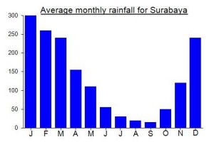
Local Average Monthly Rainfall (mm):
Location
Click on the blue arrow ![]() (top right) to see your current location on the map
(top right) to see your current location on the map
Origins and Meaning
There are two possible origins. The first possibility is that it comes from ‘botak’ meaning ‘bald’ in Indonesian. The mountain is rather grassy near the top which may lead it to be described as ‘bald’. The alternative origin is from the Javanese word ‘buta’ meaning ‘hidden’, unable to be seen.
Just did this hike as an overnight up-and-back via Tuyomerto. First up – wow. The mountain itself is just beautiful, and the views out to Semeru, Arjuno, and much more are stunning. I can see why several people on this page said it’s amongst their favorites. And, despite any negatives below, I still strongly recommend it.
In terms of practicalities, I started from Tuyomerto at midnight on Sunday night / Monday morning, and reached the summit at exactly 5am as the sun was rising. After enjoying the amazing summit views for a couple hours, the descent the same way only took 3 hours. I was with a knowledgeable local guide, sourced via the basecamp.
Simaksi is 15K for everyone, foreign and local.
The road to Tuyomerto is very steep, so at the edge of Batu there’s a parking lot where they force you to leave any automatic-transmission vehicles and then you get ojeks to the basecamp for 20K each way.
As noted elsewhere on the page, they now only count 4 pos on this trail, though there are several camping areas that are between pos. The trail is extremely easy to follow, with a few places where you choose steeper or more gradual routes.
Now, the trail ojeks. They’re on offer from basecamp to what is now pos 3, at 50K per pos (ie go to pos 2 and pay 100K, go all the way to pos 3 and it costs you 150K). They don’t run at night, which meant I had a peaceful ascent. Given that it was Monday morning coming down, there were very few people, but unfortunately 5 of them did choose the very loud ojeks. I’m told they started as a means of rescue but now are just a “convenience”, which many guides find frustrating.
There’s an unreasonable amount of trash on the trail. I’m not usually that sensitive to it (comes with the territory in Java), but this was *a lot*. Signs up everywhere about it, including threats to punish people leaving trash, but seemingly no enforcement. There are also monkeys, who dig around in the trash, and also come out on the trail and ask for food.
I’m told that basically every Saturday now the trail is shoulder to shoulder, with people choosing this mountain yes for the right reasons, but also because it’s cheaper and less strict than other options. Judging by the trash and the vast areas that seem to have recently been used by tents, I would *not* want to go there on a Saturday.
I asked around about how it became like this. Several locals I spoke with described what seems like teething pains to me. Eight years ago the mountain was almost unknown, then covid took a lot of the pressure off for a couple years, too. But now it sounds like the community is at odds with each other about how best to manage the trail, and while that discussion goes on, nobody can keep the worst bits in check. It does sound like there are a large number of locals who are pushing for conservation and sustainable hiking development, which is promising. But the conflicting interests are challenging. I hope progress/changes will be made soon.
In the meantime, I do recommend it and am still happy I went. But I am very happy I decided to avoid the Saturday night crew.
Chance upon your post as I am planning to go on 20 Dec 2024. May I check if the registration counter is open 24 hours?
Sad to hear a recent report from the Tuyomerto trail of ojeks available at 500k as far as Pos 3 and a new numbering system meaning the trail map is out of date. The latter is perhaps inevitable in Java. The former perhaps also inevitable but deeply sad. If you can’t walk it, find a new hobby. If you can’t get a normal job, please don’t churn up one of Java’s finest mountains with your bike, just for some cash.
In general in the Indonesian hiking world, there is a huge tension between the conservationists and the local residents and local hikers. In many countries, a sensible balance can be found – no motorbikes onto the mountains but access preserved for hikers. But in Indonesia you have the conservationists who seem to do their best to stop anyone from entering (and with the ojek example above, who could blame them?) and many locals happy to take money for services which will harm the terrain and many local hikers utterly clueless and arrogant about basic outdoors etiquette (playing loud music, chopping down wood to burn, paying villagers for ojeks that scare any wildlife away and irritate responsible visitors).
It is barely worth complaining as a foreigner…. sometimes you just put your head in your hands and think… let the Indonesians destroy their own natural places….. and when in Rome do as the Romans do… litter, make noise, don’t give a damn about anyone else or future generations who might want to enjoy these places.
Gunung Butak is a mountain very close to my heart and it is so sad to see the ‘progress’ made over the last 15 years from a barely-known and rarely-hiked range to what exists today.
First of all, a useful fact. It is now (in 2022) Rp15,000 per hiker at Tuyomerto trailhead near Batu, Malang for either Butak or the half-day hike Panderman.
And now for some pretty bizarre impressions, especially for someone who first visited in 2009 when you would be lucky to find a local person who had even heard of Gunung Butak. There was no basecamp, ticketing, forestry signs, and so on. You’d like to think it would be good when more local people get interested in enjoying the incredible sights and experiences in the mountains in this incredibly densely populated island.
And yet, there are so many drawbacks now that to anyone who hiked Butak before 2012 or so the current system is so regimented and at odds with enjoying the outdoors that it feels like an era has finished permanently and the future trends will be more regimentation, more rules, more discrimination, more capitalism invading the wilder areas.
I’d hoped Ramadan would mean a quiet hike up Panderman with a friend, but what it actually meant was a massive sign saying the whole mountain was closed (Panderman and Butak) for all of Ramadan. The logic behind this is not clear, especially for those who do not partake in fasting. But, as the sign was prominent, we thought it would be bad manners to ignore it, so we cancelled our hike.
Even more worrying was another sign close by, one of the rules being the following: Dilarang keras melakukan kegiatan pelatihan extrimisme dan terorisme di dalam hutan. In English: “It is strictly forbidden to carry out extremism and terrorism training activities in the forest.”
Fair enough, but just the very idea that there might be people who were so deranged that they might arrive at the basecamp, try to buy a ticket, then be told by the officer that no terrorist training is allowed here! What would they reply? Perhaps that they would have to simply look elsewhere for their training.
The rule was accompanied by an image of three men holding what appeared to be rocket launchers.
Butak was one of my favourite hikes back in 2009/10. I cannot help but find the ‘progress’ of shutting the area off for an entire month to people and having warning signs that only serve to increase worry about what sort of warped individuals you might meet on the trail as being nothing progressive at all. Degradation is a better word.
This was my first of 3 planned hikes in East Java, so I imagined things would get better! Amazingly, they didn’t! See my forthcoming comments on Arjuno and Penanggungan!
Absolutely brilliant weekend on the mystical Gunung Kawi. This remains unknown to most hikers, to the extent that there were no other groups up there with us. How many peaks in Java over 2,500m can you say that about these days on a Saturday night? Except Arjuno-Welirang, that is, which was closed due to bad weather the weekend before. Typically weird knee-jerk reaction…. We saw no rain on the entire hike! Pretty lucky for November.
It helps that there is a stone shelter at the top – no tent needed, and guaranteed proper shelter. Do note that the corrugated iron roof can be a little noisy in the wind, though and some Indonesians might be put off by sleeping near an ancient grave! Would love to know more about this building and when it was built. It is certainly decades-old, but how many decades, exactly?
The lovely cemara trees on the ridges of most East Java mountains once again sounded beautiful as the light wind blew through them, creating that ’ocean whisper from outer space’ sound. We could also hear dangdut pumping out of various places down in Batu in the valley below!
A couple of us decided to explore the southern peak too, as it is a similar height to Puncak Tugu. GPS read 2,646m vs 2,651m so only a difference of around 5 metres. Looking down to the valley connecting Kawi to Butak and this is a wild, wild area, probably with no trail. What an adventure linking the two would be. A friend who likes running on mountains did actually do a mad traverse, but not over to Butak but down the ridge vaguely towards Blitar. Just following animal trails… not easy and potentially dangerous to find your way back to civilization!
Sunrise was superb and an eagle flew just a few metres over my head. A great spot. Very much recommended and very friendly guides.
Had a wonderful trek this past weekend on Butak/Kawi, up from Sirah Kencong and down to Kraton Gunung Kawi.
This has long been one of my favourite mountains, but I had never tried the less popular routes, mainly due to being concerned about getting to/from the trailheads in time to get home the same day, so after sorting that concern out I thought a combination of the two would make for a good traverse, completely avoiding Cemoro Kandang(which is lovely and the best and only decent water source but just too popular on Saturday nights now). From Blitar station, we were up at Sirah Kencong in about 75 minutes by car. Wlingi is the closest station but it may not be as easy to get a Grab or taxi from there. Not sure. Sirah Kencong is very pleasant and pretty popular at weekends with locals wandering or biking along the tea plantation tracks.
I had very little sleep on the train from Jakarta, and despite a good start, the relentless trail up the side of Butak left me exhausted at times. If the forest hadn’t been so badly affected last year i imagine it would have been much easier, and cooler in the shade, but I found it tough going, with bright sun on my back most of the way and a dusty trail that kept getting into my lungs!
All of this was more than made up for the fabulous weather once we reached the top after about 6 hours including breaks. Most hikers were down in the savanna, and this suited me absolutely fine, what with the awful noise a considerable percentage like to make on Java’s mountaintops every Saturday night. We camped right next to the summit cairn – just us and about 4 other tents. Relative peace and quiet. And it didn’t get as cold as expected later on.
The sunrise was superb, and I had a quick wander along the Butak summit ridge northwards for a view of the double-peak of Gunung Kawi to the north-west. Then we packed up and set off down towards the south to explore the solitude of the Kraton Gunung Kawi route. In previous years it was said you needed two nights to do a full traverse. Then a few folk even managed day hikes! And indeed it was slightly easier and much more interesting than expected, with various little summits and two savanna areas. Just no water. But it would be a great spot to camp. The col/valley near Pos 5 has clearly suffered a bit from forest fires but nothing like as bad as the Sirah Kencong trail.
Note that Batu Tulis peak and ancient cairn is easily missed, lying along a side ridge off the main trial which in 2020 has a sign for P(uncak) Batu Tulis but no info on where it actually is! Batu Tulis peak itself is apparently the spot where locals believe that if you pray then your wish will come true. It is probably as old as the similar cairn on Butak summit.
Further down after Pos 3 the trail becomes fairly standard steep forest trekking again until you get to the edge of the forest and see what looks like a Balinese temple on the left. And then it’s just a few minutes to the car park for the temple and prayer complex, which seems pretty popular, popular enough for there to be several warungs. I imagine you could ask around and get an ojek to the main road, but we arranged transport via a friend in advance, as i had a train to catch back to Jakarta from Kepanjen. I was a bit worried about the lockdown starting at midnight and arriving back at 4am, but as it turned out, surprise surprise, the actual details of the lockdown were still being discussed and it seems like trains are already complying with whatever the new rules are going to be anyway. Just don’t re-introduce the SIKM again and force me to board/alight in Bekasi!
A brilliant weekend. For strong hikers who have never been to Butak before, I would say up from Tuyomerto and down to Kraton Gunung Kawi gives you the best understanding of the mountain. Sirah Kecong forest needs a little time to recover but will hopefully be a pleasant trek in future years. The tea plantation alone makes it worth a try.
I did Mt. Butak as a long day hike, started from south (Kraton Gunung Kawi temple) and ended north in Tuyomerto/Batu. The ascent from the Temple is challenging, first because it is steep and second because the way is overgrown in many parts, but thanks to some marks and with a GPS-file still relatively easy to find. Wear long clothes and gloves, so that you can use your hands too.
The ascent consists of two parts – first you will just walk up for 4.3km and almost make 1400 meters in altitude difference. The way starts on the left of the temple and is about for the first 2km easy to see and moderately steep before it gets slightly overgrown in some parts and steeper. At around 2’550 meters you reach a first peak with an Indonesian flag and space for camping and from there you have a view towards Butak peak (2’868m) and the second part of the ascent, which is another 3.7km, but only a little altitude difference. You will first go down shortly on a clear path before you ascend again for a moment in very overgrown territory to reach Batu Tulis (actually its true peak is a bit more to the right not on the way). From there it continues roughly flat through a sea of flowers and plants before you descend into a small Savanna valley. You have to turn right and walk through this beautiful valley and then turn left again towards Butak peak. In this part, you can enjoy beautiful views towards a minor peak, Arjuno, Malang and Semeru. You will slightly descend before reaching another Savanna. From there, the way goes straight up and you will finally reach the ridge and have views into the big Savanna of Butak. You do not have to go down to the Savanna, but you can follow the path on the ridge, passing by a small temple and a cave, and arrive straight on the summit. It took me just over 5h to the peak and I am rather strong in walking up, but had to make many small breaks to drink and breathe…
The descent from the peak to the Savanna is short but steep. The Savanna is an ideal camping ground and there is a drinking water spring. From there to Tuyomerto, it is around 10km, but ideal to go down (and up with camping gear) on a very clear path that is never really steep and mostly quite flat. Around 3h should be sufficient. With a trail motorbike, you can even drive up a big part of this path. Myself, having unluckily injured my knee just before the peak, I was very fortunate that 2 local guys gave me a ride down to Tuyomerto for around the last 6km.
See also: https://www.wikiloc.com/hiking-trails/kraton-gunung-kawi-mount-butak-tuyomerto-51636736
Interesting comments from Petter from Norway who had to use the southern route from the temples as the main route from Tuyomerto is closed due to forest fire in the Panderman area at the moment….
” I am informed that the entire area has been closed off (and that people
enforce it) due to a large forest fire last week mainly on Gunung
Panderman.
Plans had to quickly change and I looked for alternatives including tracks..
Ended up doing the route from the south, start at a nice looking Temple,
Did not seem that anybody had gone there for some time.
The trail was badly overgrown, mostly the higher part.
Certainly worse than Liman south summit.
I was a bit tired when getting back down to my taxi, he had
patiently waited for 8 hours (I had told him 7, but underestimated
the BIG bush-walking part..) Overall, this was a pretty tough day-hike.
Ther is also about 150 meter extra elevation each way as one crosses
another summit along the way..”
Did this one again last weekend – still one of my favourites in Java. It was surprising to see how much more popular Butak now is after a gap of 8 years – nobody had heard of the name back in 2009! I got the Gajayana night train from Jakarta to Malang and with my co-hikers sped off to Tuyomerto to meet the reliable Pak Budi and Wassis our strong porter. Quite why all the signs spell Butak with an ‘h’ is not known.,,,.. would be interesting to check the Bako map of the range to see what their spelling is.
Great to see more hikers enjoying this place but it does inevitably means there’s a bit more litter on the trail now (and a bit more noise from campers in the middle of the night).
We were very lucky with the weather…… no rain at all, a brilliant sunset seen from the summit, distant mountains peeking above a sea of clouds below.
I did meet one group who had climbed from Kraton Gunung Kawi. It had taken them a full day. The sky at night was beautifully clear.
Flights back to Jakarta from Malang on a Sunday afternoon tend to be very pricey, so I got a train to Sidoarjo, Gojek to Surabaya airport, and flew back from there instead.
Gunung Butak Traverse
I have climbed Butak twice from Batu and found the descent by the same route rather uninspiring. A more interesting, but strenuous, option is to traverse the mountain from Batu, via Cemoro Kandang and Gunung Kawi, to the Chinese temples at Desa Pesarehan (Kawi temples) on the southern side of the mountain. I have not done the traverse; the information below is from a guide at the Kawi temples in December 2015.
For the traverse, I would recommend climbing from Batu, camping at Cemoro Kandang below the summit, and descending to the Kawi temples the next day – rather than the reverse. This is for two reasons: (a) the Cemoro Kandang – Kawi leg is longer than the Batu – Cemoro Kandang leg, and (b) the vertical height on the Cemoro Kandang – Kawi leg is greater. The Batu trail head is at about 1,300 m cf the Kawi temples at about 800 m. In fact, the Kawi guide informed that if one were to ascend from the Kawi temples side, an additional camp on the mountain would be necessary (in open fields, known as Savana 1).
The Butak summit is known locally, from the Kawi side, as Gunung Sembilan (nine). The only reliable source of water between Batu and Kawi temples is at Cemoro Kandang.
The Batu guides/porters, with whom I have climbed, do not know the Cemoro Kandang – Kawi temples trail. It may be necessary therefore to arrange for a guide from Kawi to meet you at Cemoro Kandang for the descent to Kawi. Encourage the Batu guides to join for this descent to learn the route.
Of course, logistics for a traverse of the mountain would be more complicated, including repatriating the Batu guide/porters. The road trip from the Kawi temples to Malang takes about one hour and from Malang to Batu another hour or so. There is simple accommodation and some larger hotels at the Kawi temples.
Kawi temples guide/contact: Dino – 0877 8000 0183; dinodiorama9@gmail.com.
Batu (Desa Tuyomerto) guide/contact: Budi – 0815 5671 6354 (as of August 2015)
Just completed summit 5-July-2016. Great views and weather. Camp site almost deserted due to Lebaran. Guide Budi definitely recommended – we paid Rp500,000 for the 2 days
Hi, how can i contact.your guide?
Armed with gps me and my wife tried to hike this one. We left Tuyomerto about 2am. Soon after the start of the hike we saw two reasonably big creatures standing on our path. My wife’s first word was puma 🙂 These were two of those cat-like animas, about 80-100cm height. I doubt pumas live here, but I wonder if anybody knows what kind of animals we could have ran into ?
Needless to say, we turned back 🙂
http://www.arkive.org/javan-leopard/panthera-pardus-melas/
https://id.wikipedia.org/wiki/Ajak
https://en.wikipedia.org/wiki/Javan_leopard
what kind of animals you find from link above??
It wasnt Ajak. I would say it’s the 1st link. It seemed to us those animals were black like pumas, but it was night time with us using headlights. There’s a chance the collor of the fur was different.
There are 4 species of wild cat in Java: tiger (panthera tigris sondaica), leopard (panthera pardus melas), leopard cat (prionailurus bengalensis) and fishing cat (prionailurus viverrinus). (See http://www.wildcatconservation.org/wild-cats/asia/
)
Tigers survived in Meru Betiri National Park until the 1980s, but are probably extinct now. Fishing cats live in low-lying wetlands and coastal areas.
Leopard cats are quite common and have adapted to modified habitats like secondary forest, plantations and farmland. But they are quite small, less than 40 cm high.
So what you saw was probably a leopard, which is larger and sometimes has a black coat. Sightings have been reported from most National Parks in Java so it would not be surprising if they lived also in a large, wild area such as the Butak massif.
cukup menarik untuk mendaki gunung butak ini via dusun Tuyumerto-pesanggrahan batu, trek yang bervariatif dan jalur yang tertutup semak dan ilalang yg cukup lebat …
Mount Butak via Tuyomerto village batu, east java Indonesia
https://www.youtube.com/watch?v=qx6hARNeQrM
I was in Batu last week and decided to go to Gunung Butak.
After I downloaded the very useful gps track from this website, I decided to start walking from Songgoriti at 1am to reach the summit for sunrise. There was full moon and together with the headlamp made the visibility good for walking.
It took me more than expected to reach the summit because the last half of the climb before the alun-alun was quite overgrown and with many trees and branches to jump or go under, making difficult keep a good pace.
My plan after reaching the summit was to descent following the track to Sirah Kencong, but I met some Indonesian people who were camped at the summit and they told me to join them to walk to Kraton Gunung Kawi. As this route was not commented here, I decided to do it and log the track.
The route from Butak to Kraton Gunung Kawi (KGK) is in better condition than the one from Batu to Butak.
As you descent from the summit, the path heads south and after descending 100m you arrive to one area called Telaga Gentong, where there is a good water source, a small hut made of branches and tin and space to camp. There is also a Holy Place where people do some rituals.
From here you have 3 – 3,5km of flat/up/down terrain and the last 3,5km are pure descent, in some parts quite steep. The path is easy to follow, i took the risk of doing it on my own because the people I met were waking too slow to reack to KGK before dark.
The track log is ready to download and transfer to GPS device on wikiloc.com (user pedro2)
Please keep paths and capms clean, bring a 500ml empty bottle with you to use as a garbage bin. All your food wraps, even the part you tear off, cigarette butts, tissue after going to “toilet”, batteries, etc can fit in there… you would be surprised. And avoid cans and other food “containers” that you cannot put inside the bottle unless you take them back with you. Please avoid increasing the amount of litter in Indonesia’s beautiful Nature.
Gunung Butak: Few locals know of the mountain as Butak; instead, they know of Cemoro Kandang, the alun-alun (open tussocky fields) below the main peak. Mention’ Cemoro Kandang’ when making enquiries.
Butak is apparently Javanese for ‘botak’, bald, perhaps referring to the open tussocky fields. Cemoro is Javanese pronunciation of ‘Cemara’ (Indonesian), the tall trees with drooping, needle-like leaves that grow above about 2000 m. The origins of ‘Kandang’, meaning ‘stable, enclosure, pen’, is obscure.
The highest peak is known locally as Gunung Gede (Javanese) or Gunung Besar (Indonesian), and lies immediately to the west of the water point on Cemoro Kandang. It can be identified easily as the section of the range without any trees – those to the left and right are covered with trees. The peak is marked by a two-metre high stone cairn.
Guides at Desa Tuyomerto: There are two Budis – Budiraharjo (father) and Budiardi (son – 0877-5997-6182). I climbed with Budiardi – highly recommended.
Overgrown Tracks: Indeed, much of the forest is depleted and suffers from periodic fires. Accordingly, primary regrowth covers much of the mountain and obscures the track. Budiardi is doing his best to keep the track open for climbers.
In addition, knee-high undergrowth covers much of the track. You should wear knee-high gaiters and/or long trousers to avoid having your shins ripped red and raw.
Summary: Despite an uninspiring climb, the views of East Java mountains from the summit are awesome. To the west – Kelud, Liman and Lawu; to the east – Arjuna/Welirang, the Semeru-Bromo complex and, peaking up behind this complex, Ruang and Argopuro. Butak certainly offers the best views of all the mountains of East Java. Highly recommended.
Contributed by Nick Hughes, September 2013
My girlfriend and I made it to the top about a week ago, it was a wonderful trip! We walked on our own and used Dan’s gps track, thanks a lot!
The track was very overgrown, and we made a couple of wrong turns.
There has also been a wildfire so a lot of trees had fallen over the track. This made it challenging at times and time consuming.
However, when we saw the sunrise over Semeru and Bromo it was all worth it. The views over Kelup and Arjuno are just breathtaking as well.
Photos for those who might be interested:
http://www.skogtur.blogspot.com
Didrik
Wow, beautiful pictures! Look like you had a wonderful trip!
If you only had time to trek one mountain, which one would you do: Gunung Butak, or Gunung Rinjani? We are planning a trip to Indonesia for next year 2015, but we will probably only have time to do one since we’ll also be visiting family & relatives.
Thanks,
Lufi
Hi Lufi,
Just saw your comment.
If I just had time for one of those two I would choose Rinjani. The lake segara anak is just too beautiful to skip.
However, Gunung Butak is without a doubt the more quite mountain in terms of visitors (at least the time we went there).
So if your are after a more “wilderness experience” this might be the one to chose.
I got some photos from our trip to Rinjani here:
http://skogtur.blogspot.no/2012/04/gunung-rinjani.html
Whichever you choose enjoy the mountains!! 🙂
thanks Dan . i made it. guided by your Gps Track 😀 . i climbed this mountain alone . thanks God u give your nice track . 😀
I finally made it to the top of Butak (September 2012), guided by Pak Budi (hp:085749225243) of Tuyomerto, who is very capable and helpful.
I did this as a day hike, starting at 05.00, reaching the summit by 11.00. and returning to Tuyomerto at 16.30. This is close to the limit for a hike entirely in daylight; for a day hike on this route you’ll need a dawn start, confidence in your speed and a flashlight in case you’re not back for sunset! During my September visit, the lower stretches of the trail were quite overgrown. There is lots of potential for erosion through landslides on the steep ascent section between 1700m and 1900m and there were many fallen trees to scramble over at about 2300m altitude. Potential hold-ups abound.
The hike was as described by Dan, except that the alun alun campground is at 2670m (not 2460m), there are no “Pos” signs at any of the campsites and the musholla photographed in 2009 has completely vanished. I heard there was a dispute between Tuyomerto villagers hoping to pipe spring water from the alun alun and the “owner” of the well, who is from a different village; perhaps that has affected the maintenance of the trail.
A path comes in from the east at a small campsite at 2500m (what Dan calls Pos 6?) and the trail above that is in good condition. It would be interesting to check out that eastern route, or the alternative from Sirah Kencong on the Blitar side as the paths on the upper slopes of the mountain are much more user-friendly than the approach from Tuyomerto suggests.
The alun alun remains an excellent campsite, having a stone well with a water pipe, a stream and even a plastic shower curtain! Pak Budi refers to the alun alun as Cemoro Kandang; in fact, “Cemoro Kandang” seems to be a better-known term around Tuyomerto than “Gunung Butak”.
It is easy to understand Andy’s difficulties finding the summit trail. It’s actually a steep, but straightforward 40 minutes along a well-trodden and well-defined path- the hard part is getting on it! After entering the alun alun from the Tuyomerto side, the main trail crosses the clumpy grass area and then descends into a slight depression, passing half a dozen flattened out tent pitches before reaching the well in the center of the crater. The most prominent trail continues from the right side of the well, crosses the grassy area for a few hundred meters and then enters the forest before descending toward the southeast, as described by Andy. Before that, however, you must turn off to the right on one of a series of less obvious trails heading off toward the forest, about 100m away. The trail we took was the fourth of these, about 300m after the well, just beyond a slight crest. This trail is flat and slightly overgrown for the first 20 meters after entering the forest, but then starts to climb and becomes clear and well-defined.
We had excellent views of both distant mountains and nearby plains. The complex topography of Gunung Kelud was especially appealing, seeming almost within touching distance.
Logistics note: If you fly into Juanda Airport in Surabaya, Liza Travel (telephone: +62341333037) runs a share taxi service to Malang/ Batu. Although there was only one other passenger, I paid just Rp80,000 to be dropped at my hotel in Batu. Of course flying in and out of Malang would be better, but flights there stop by mid-afternoon.
Sounds like Butak is becoming something of an elusive beast! If you have photos and/or fancy writing a full account for Panderman then we could add a new page for it. A chap living in Malang mentioned that it might deserve its own page.
Congratulations, John, on what appears to have been an excellent week of gunungs in Jawa Timur.
An unforeseen hitch thwarted my attempt to climb Gunung Butak.
Visiting Tuyomerto village the evening before the planned hike, I recruited a guide who seemed confident of the route.
Next morning we set out briskly from Tuyomerto and quickly gained altitude. After leaving the plantation area, we entered a forest trail, passing well-used campsites and trees nailed with signs opining that the beauty of nature is proof of God’s greatness. But with our altitude reaching 1800m and the summit looming large ahead, an uneasy suspicion began to form in my mind about the rapidity of the ascent.
Indeed, it soon transpired that we were in fact climbing completely the wrong mountain!
The summit we attained was actually Gunung Panderman (2043m), the pyramid shaped peak that lies at the northeast edge of the Butak-Kawi massif and towers above Batu city.
This hike- about 4 hours round trip- is actually very enjoyable in itself and must be popular, judging by the well-worn trail and TNI commemorative plaque and pillar in a clearing at the summit. There are spectacular views toward the north- Arjuno, the Anjasmoro range and the farmed valleys in front of them and a clear sighting of both Butak and Kawi from a campsite at about 1900m. Still, a disappointing alternative to the Butak summit I had expected!
With hindsight, my ojek driver had implanted a firm idea in the guide’s mind that the “puncak” I wanted to reach was Panderman, and he remained “buta” to my insistence that the puncak I wanted was Butak, since he was not familiar with that name.
On the bright side, I now have a pretext to return to Batu to set things right…
We just had a rather wet and misty trip to Butak, and failed to reach the summit. No view and no summit bagged is not a good way to start the hiking season.
The hike was a little more challenging than expected, partly because of the wet weather, but also because the trail was very overgrown in places. We were lucky to secure the services of 4 excellent porters in Tuyomerto, who hiked at a good pace with our bags while also wielding their machetes to clear the overgrown trail. Their 200k rupiah for a one way service was well earned. Ask for pak budi in Tuyomerta village.
Our porters left us at a windswept, misty, and wet alun-alun and returned to Tuyomerto. Cold and wet, we decided to take a break in our tents and eventually decided to leave the summit bagging to the morning when we hoped the weather would have cleared up. Unfortunately, we woke up to rain and mist and at 5:00 am we headed off towards the summit (location stored in a GPS) along the path through the alun-alun. However, as the trail entered the forest below the summit, it was also quite overgrown and hard to follow. The trail seemed to be heading off in the wrong direction, downhill to the southeast. We turned back and bashed around in the forest and understory for a while trying to take the direct route to the summit. With time pressing on and a 2:30 pm flight from Malang, we returned to break camp, soaking wet with the bitter taste of our multiple defeats – no view, no summit, and no time for a good breakfast.
We stayed in the Sumber Hotel in Batu, which is highly recommend. Simple, clean accommodation and the staff were very friendly and helpful – they organised an early wrapped (di bungkus) breakfast and our ojeks to Tuyomerto. We also booked the same ojeks to bring us back to the hotel on Sunday, and the hotel arranged our taxis to malang and allowed us to used the mandi get cleaned and changed into dry clothes.
Judging by Dan’s photos, the views from Butak are spectacular and in sunshine the meadow campsite would be a lovely (if lumpy) campsite. We may well return an try this as a day hike when we climb Semeru later this year.