
Facts
- Elevation: 1,881 m (6,171 ft)
- Prominence: 958 m
- Peak category:
 Spesial
 - Province:
 Lampung
 - Coordinates: -4.9108, 103.9630
- Rating:

 (3 votes) Add your rating
 Loading...
Photos


Bagging It!
Gunung Seminung is one of the most strikingly beautiful mountains in southern Sumatra and is well-known by those who visit Danau Ranau, the lake beneath the mountain and second largest body of water in Sumatra (after Danau Toba in the north). It might be thought of as the twin of Lake Toba’s Pusuk Buhit, as both are the guardian mountains lying beside their respective lakes.
The mountain is the remains of an ancient volcano which erupted, supposedly turning a wide river flowing at the foot of the volcano into the large lake we see today. There is still limited volcanic activity on Seminung and most people who come to Danau Ranau visit the hot springs at the base of the mountain.
A local guide who has climbed the mountain recently is almost essential because there are several tracks on the lower section of the hillside and few signs at junctions. Despite being famous in the local area it is not climbed as often as you might imagine and so expect occasional overgrown sections of trail on the higher slopes. As usual in Sumatra, it is best to hike with a minimum of two other people just in case you should be unlucky (or lucky!) enough to meet one of the very few remaining tigers in Lampung.
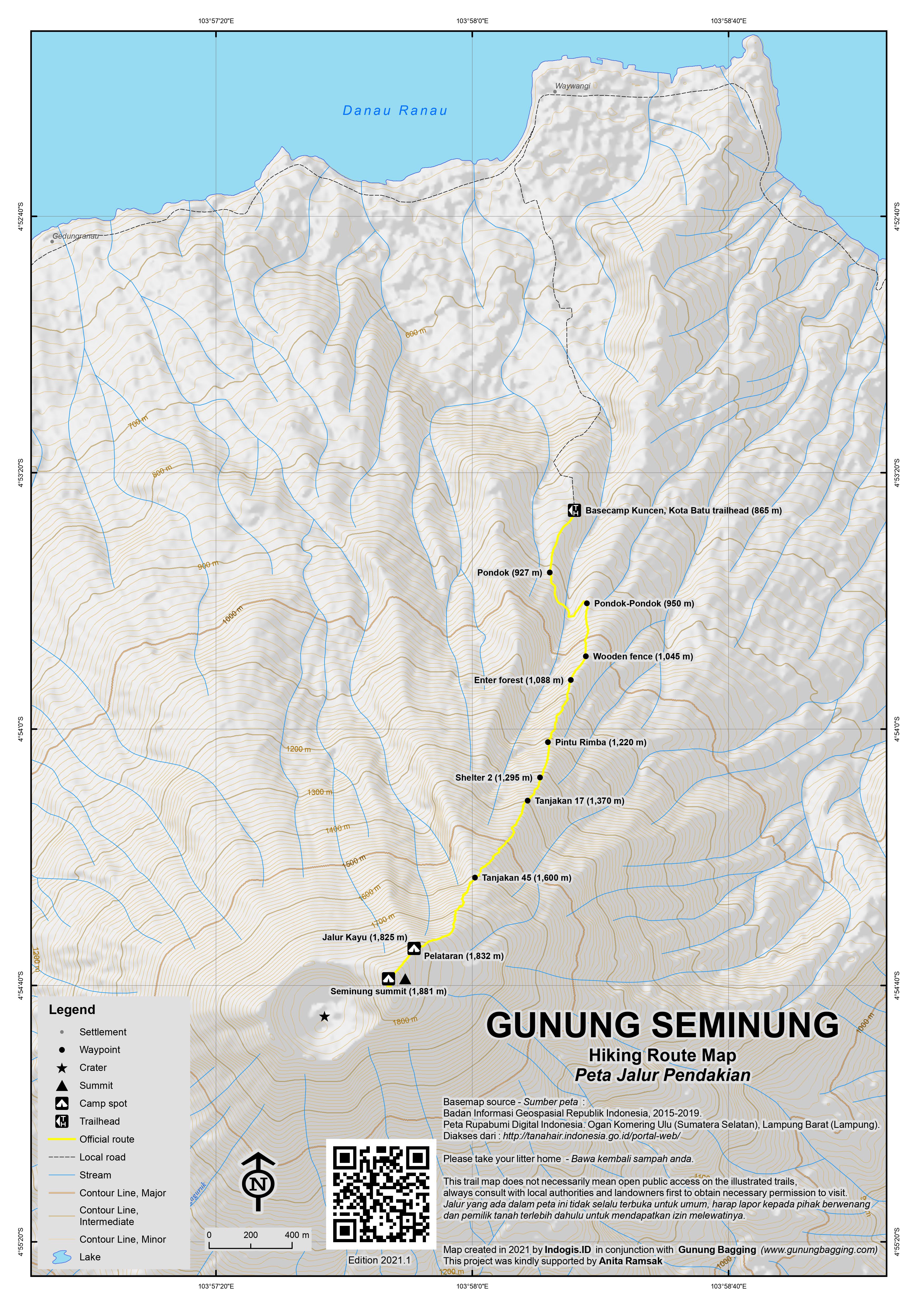
Before hiking, remember to visit the small town of Kota Batu and ask to be directed to the house of the person who you must ask permission to climb the mountain. Foreigners are sometimes asked to have their photograph informally taken prior to starting the hike. You then need a second, equally important, permission granted to hike from Pak Kuncen, the mountain’s guardian or caretaker, who lives with his wife at what in 2020 is known as Basecamp Kuncen (865m).
This spot is the official trailhead and there are several ways to get there. You can hire a small boat from either Kota Batu or Wisma Pusri to cross the lake to the hot springs (Air Panas, 530m) at the foot of the mountain or simply take an ojek from Kota Batu. Arranging a boat is very easy. From Wisma Pusri the crossing takes just under 30 leisurely minutes and is a wonderful way to see the Ranau area. It also gives you the option of having a soak in the hot springs after your hike before getting the boat back across the lake.
By motorbike (ojek), there is a new network of roads at the base of the mountain near Kota Batu that vary greatly in width, so using a car is out of the question. You can weave your way through the plantations to Air Panas this way, and even reach the basecamp itself where there is space for motorbike parking.
Some locals may suggest you follow a higher trail above the basecamp and leave your bike near some small wooden buildings (950m), but this is a bad idea because you will need to descend to the basecamp to register before the hike, and again after your hike, meaning extra effort and time required without any good reason.
After you have spoken with Pak Kuncen at the basecamp, and registered your hiking group, you can finally get started. The trail leads up through the plantation, comprised mostly of coffee, avocado, and a little pepper, past a simple wooden hut (927m) before a collection of 3 or 4 wooden buildings (950m) where there is a water pool and space for changing clothes afterwards. This is also where some locals leave their motorbikes if they have used a different plantation trail in from Kota Batu.
Beyond the cluster of simple wooden buildings is a crucial junction (960m) where you turn right off the plantation trail. This should have a sign for the ‘puncak’. From here, navigating is fairly easy, as the trail leads up to a wooden fence (1,045m) at the edge of the plantation where there are some views. Beyond this the trail enters forest (1,088m), then reaches a small clearing (1,115m) with good views of the lake below.
Despite having already entered forest, the official ‘Pintu Rimba’ is at 1,220m and is marked with a wooden sign that in 2020 is beginning to crumble. Shelter 2 (1,295m) soon follows but has little to recommend it unless you started very late and want to camp.
The trail now begins to get steeper at a spot known locally as Tanjakan 17 (1,370m) after which giant bamboo lines the way. This is a great spot to listen out for siamang, of which there are plenty in this forest. The steepest part of the trail is Tanjakan 45 (1,600m) and one point in particular requires the use of all four limbs and extra care.
Beyond here, the trail is delightful as the vegetation changes and you feel that you are nearing the top. Look out for pitcher plants from here all the way to the summit. The next landmark is a large toppled tree trunk which is used as a path (Jalur Kayu 1,825m). Immediately after this is the first of many small camp clearings (Pelataran, 1,832m) and you can see the summit ahead of you.
The view opens out at this point, and in clear weather you can see the lake below and Gunung Pesagi, Lampung’s highest mountain, to your left. In less than ten minutes you will be at the summit, an area with several more camp spots and even better views, including down to the little island named Pulau Marisa/Meriza and over to the shapely Gunung Pugung to the west of Danau Ranau. Gunung Pugung is a little higher than Gunung Seminung and remains highly mysterious, with no reports of any hiking groups having reached the top.
To the west of the highest point of Gunung Seminung is the densely-forested and wild crater which is seemingly dormant. There is no path around the crater’s edge, but the finest views are from the summit anyway, especially from a large rock which is on the very edge. There is also a little edelweiss near the top. The lower south-western peak on the other side of the crater 500 metres away from the true summit is 1,804m according to the Bakosurtanal map.
In total, fit hikers should have reached the summit in under 3 hours, and can be back down at the basecamp in less than 2 hours, although camping here and witnessing sunset and sunrise would likely yield the best photo opportunities. Views of the lake and nearby mountains are stunning.
Bagging information by Dan Quinn (October 2012, updated July 2020). The July 2020 expedition was kindly supported by Tjiasmanto Conservation Fund.
Trail Map
For a high quality PDF version of this and other trail maps, please download from our Trail Maps page.
Practicalities
- Getting there: There are regular buses from Bandar Lampung (Rajabasa terminal) to Liwa (where you can change) and one bus per day direct to Ranau. There are even buses all the way from Jakarta – Ranau Indah and Tispa both leaving Bekasi at 12 noon, calling at Kalideres, Cikokol, Kalianda and many other spots before finally arriving in Ranau usually around 5am. There are also plenty of buses from Palembang via Batu Raja. If driving, if can take from between 6 to 8 hours to reach Danau Ranau from both Palembang and Bandar Lampung. Boats across the lake from Wisma Pusri to ‘Air Panas’ cost about Rp 135,000 return (back in 2012 – probably double that in 2020) but are more expensive if you plan to cross at night for a dawn ascent.
- Guides and GPS Tracks: Want a PDF version for your phone? Looking for a guide? Need GPS tracks and waypoints? Gunung Seminung information pack can be downloaded here.
- Trip planning assistance: Would you like Gunung Bagging to personally help you in arranging your whole trip? Please contact us here.
- Permits: You are requested to report to villagers in Kota Batu to let them know of your plans to climb the mountain and then register at the Kuncen Basecamp and pay a small fee. You may also have to pay a small fee at the ‘Air Panas’ pier.
- Water sources: None available. Be sure to take plenty with you.
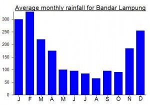
Local Average Monthly Rainfall (mm):
Location
Click on the blue arrow ![]() (top right) to see your current location on the map
(top right) to see your current location on the map
Just visit Seminung today. Very wide and clear trail start from main road to Pekon Lombok. Simple registration, 5000 rp cost. Simple mountain, because Basecamp around 1050 m elevation. We reach “puncak” less than 2 hours. But views is great!!!
Now that buses are running again to Sumatra I decided to head over to Lampung, a plan made quite last minute, like most plans this year what with the changing rules and regulations. The aim had been to hike both Seminung and Tangkit Tebak, but no guides could be found at short notice for Tebak due mainly to Idul Adha preparations. So it ended up just being Seminung.
I remember reading about the Ranau Indah bus in the Lonely Planet, and thinking how the rigid inflexibility of my regular Monday to Friday working week meant that I just missed out on being able to do this as a weekend trip.
There are two bus companies running this route now, with newcomer Tispa. They both leave Bekasi around 12 noon and head via Kalideres, Cikokol before Merak and the ferry. I got on at Kalideres after the Cikokol ticket agent failed to reply to my messages.
Current COVID fare is 350,000 which I think is fair enough, but locals are not too happy given it is normally around 230,000. The Ranau Indah executive bus is quite nice and even has USB charging sockets. Sadly, as is so often the case in Indonesia, most of the sockets do not work, so you end up having to share the few that do work with other passengers. Quite irritating.
Strangely there were no checks that I noticed as we headed over to Sumatra and despite having a Rapidtest document ready I didn’t actually need it. The boat itself was the usual scrappy affair, with the guy who did the safety briefings morphing into an oil salesman (not snake oil, but close!) in what in most countries would be regarded as a gross abuse of authority – listen to me for this genuinely important safety briefing and then whilst I have your attention buy this product from me that is completely unrelated. Shocking behaviour really.
The dangdut was bouncing around my head as we finally reached the southern shores of Danau Ranau at 0445am. I hopped off and called my contact there, whom I had told to be ready for an immediate hike so we could get some great early morning photos (usually the best time). Alas, he was still asleep, so it was usual round of coffee and admin, with a local police or military guy coming round to check me out before allowing us to hike.Starting early on this mountain seems almost impossible – if you want sunrise and sunset you need to camp up there.
Three young chaps came with me, and we finally got started after 2 hours or so of delays. But they decided to leave the bikes above the Kuncen Basecamp, and a visit to register there is essential, so the hike started with a descent of nearly 100m, more chit-chat, more admin, and then a hike back up to the motorbikes! All this with no sleep since Jakarta!
The hike itself was great – the trail actually had signs this time an the weather was perfect – back in 2012 we had neither of these and failed due to too many junctions with no signs and poor weather! Two of Pak Kuncen’s many dogs followed us all the way up the mountain – all the way to the top!
One group were coming down – it seems it is growing in popularity and given the views from the top rightfully so. We heard the beautiful call of the siamang very close to the trail at one point. Sadly at the top there was a fair bit of litter left behind. What a shame. Even if 100 million Indonesians know not to leave rubbish on the mountains, there are another 160 million who don’t! A very difficult situation that stems from poor education and incredibly short-term thinking.
After admiring the crater and talking about local mystical stuff we were back down in less than 2 hours. I made it quite clear I wasn’t especially keen on descending to the basecamp to sign out and ascending again back to the motorbikes afterwards, so thankfully just one guide went down for our group as a whole.
Back in the village, it was clear that transport back to Kota Bumi, Bandar Lampung and Jakarta generally leaves at 9am, so anything from lunchtime onwards is difficult to arrange except by hiring a whole car to yourself. However, the solution is simple… get an ojek 27km to Liwa, where there are more buses and more travels. I was soon on a travel to Bandar Lampung (Rp110,000) admiring the West Lampung scenery. Alas Gunung Tebak will have to wait until next time.
Once back in Bandar Lampung (930pm) I finally got some sleep. The next morning I visited the very worthwhile Situs Purbakala Pugung Raharjo, which features some standing stones and most impressively a stone and grass pyramid structure – all from the Hindu-Buddhist era. It took around 1hr15min to reach from the centre of Bandar Lampung. I then headed to the airport for my first COVID-era flight back to Jakarta. Just Rp220,000 with Sriwijaya. Cheaper than the taxi from the airport to where I live!
Hi Dan
In the report it mentions Gunung Pugung has never been climbed. I have a holiday bungalow in Krui overlooking Gunung Pugung and have a plan to climb it but the locals here say the same that it has never been climbed and there a Tigers up there
If you plan to climb it one day do let me know I would be keen to join and I can offer accommodation here in Krui
Cheers Lawrence
Hi Lawrence. Thanks for your message. Gunung Pugung now has its own page here…. https://www.gunungbagging.com/pugung/
Yes, I have not heard of anyone having climbed it in recent times, but as the topo map suggests there is a triangulation pillar at the top, it must have been climbed at least once to make the pillar for mapping purposes, but perhaps so long ago that nobody alive remembers!
Tigers could well be living in the forest there, as there are certainly tigers in that part of Lampung and if I were a tiger I would imagine Pugung would be a good spot to avoid disturbances and hunt for food!
Do keep me updated on if you hear anything. Doubt I will be in the area anytime soon but you never know…
There is talk of the local tiny Banding Agung airport being developed so that Wings etc can fly there from Palembang (and perhaps even direct from Jakarta?) They say 2018 so that probably means 2020 ish.
Fingers crossed for this as the lake is lovely but extremely time-consuming to get to at present. Local government officials have obviously been watching as the new Toba airport up in North Sumatra has been opened and already receives international flights.
Well what a weekend it was. The plan was a warm-up with Seminung before hitting my 50th Ribu on Gunung Pesagi. I got the DAMRI bus from Gambir station to Bandar Lampung on Thursday night. Huge amount of traffic at Merak – people returning home for the Idul Adha weekend. We arrived in Bandar Lampung at about 6.30am and Heri met me at around 7am with his trusty morobike. Off we headed towards Danau Ranau, via Kota Bumi and Liwa. By mid-morning most villagers were cutting up cattle for the celebration and whilst the roads were clear of traffic for the most part, there were tons of pedestrians wandering around, finely dressed.
We got a good glimpse of the mysterious Gunung Tebak and were in Liwa after about 5 and a half hours on the bike. Another hour and we were near Danau Ranau. Neither of us knew much about the area so we first headed down to Lumbok after asking a local chap who was sitting by the side of the road in a trance if the left turn did indeed take us to the lake. However I think he would have nodded at anything we said.
The road did indeed take us up the hillside and back down steeply to the lake itself but on arrival we were informed that the main places to stay were near Kota Batu (‘Stone City’) back the other way towards Muara Dua. After chatting with locals in Kota Batu about how long it might take to reach the summit of Seminung (ideas ranged wildly from 1 hour to 6 hours!) and asking official permission at a village house to climb the peak the following morning I was beginning to grow quite irritable, having had very little sleep. Luckily we found Wisma Pusri overlooking the lake and about 3 or 4km outside Kota Batu, presumably in the direction of Banding Agung.
The staff at Pusri agreed to find us a boatman who could take us over to the starting point at the hot springs ‘air panas’ leaving at 3am from the hotel pier. The plan was to reach the top just after dawn so as to enjoy the best of the views before the haze kicked in.
The following morning it was pouring with rain but we set off anyway. Heri had been unable to find a local who had climbed the peak and was willing to lead us up to the top but seemed unconcerned after we were told it was a straighforward track with no junctions or route-finding issues. We ended up waiting til after 5am to set off hiking because the rain was persistent and it was immediately difficult to work out the correct trail from the hot springs pier in the darkness.
Eventually we found what appeared to be the right trail, leading up from the hamlet to the left of the pier up through coffee plantations. Every ten minutes was another hut, many of them lived in but vacant perhaps due to Idul Adha festivities nearby.
It was a sweaty ascent and the ‘wise words’ that route finding would not be a problem soon turned out to be some of the most useless advice I have ever received. The lower slopes are covered with farm tracks criss-crossing each other. We were invited in to a wooden house (at about 950m) by a pleasant Sundanese chap who gave us a drink and told us we had gone the wrong way. He also started telling stories about some sort of spiritual link between the hills in Lampung and those in Banten.
He agreed to show us the route, and we both imagined he would take us to the top. He led us across a ‘jalan potong’ (short cut) which was barely a track at all and up to a small cluster of wooden houses.
Here, he made his excuses and told us he was off to the market and pointed us in the right direction. “If I’m not mistaken, it’s about half an hour from here to the top”, he said. Considering we still had almost 1,000 metres to climb this seemed highly implausible to say the least but I gave him Rp40,000 for his help and we parted ways.
After another 30 minutes of climbing we were, of course, nowhere near the top and had, in fact, come to a dead end by a small collection of logs. Nobody was in at any of the other houses but we descended a little way to see if there was an alternative route. We climbed up again, reached another junction and retreated once more.
The weather was poor and by this time we had spent over 3 hours ascending and descending, trying to find the correct trail. I was completely fed up and annoyed that we hadn’t been able to find a local guide and at Heri’s confidence that we wouldn’t need one. Given that we would be climbing Gunung Pesagi the same evening and that Seminung was supposed to be a straightforward warm-up for that I decided we should forget it and make our way back down to the pier and then the hotel.
The weather remained poor so in retrospect we wouldn’t have enjoyed the fabulous views that can be seen from the higher slopes of Seminung anyway.
A poor start to the trip’s hiking activites but one to definitely go back to (and with a local guide who has climbed it recently and genuinely knows what he is talking about!) Luckily Pesagi turned out to be much more successful (and finer weather)