
Facts
- Elevation: 2,050 m (6,726 ft)
- Prominence: 1,320 m
- Ribu category:
 Tinggi Sedang
 - Province:
 Jawa Tengah (Central Java)
 - Coordinates: -7.1872, 110.3445
- Rating:

 (17 votes) Add your rating
 Loading...
 - Other names: ꦒꦸꦤꦸꦁꦈꦔꦫꦤ꧀ Known as ‘Karungrungan’ many centuries ago, according to the Bujangga Manik.
- World Ribus ID: 69112
Photos


Bagging It!
Just an hour by car from the city of Semarang is Mount Ungaran. Many people visit the southern slopes of this mountain, not because of the mountain itself but because of the impressive ancient Gedong Songo temple monuments which are scattered across the hillside south of the peak. The name ‘gedong songo’ literally means nine buildings, and these Hindu relics date from approximately 900AD and were ‘discovered’ in the nineteenth century by Stamford Raffles and later restored.
This area is a popular weekend retreat for those living in Semarang and so there is an abundance of accommodation in the nearby town of Bandungan. Many local hikers camp on the mountain at weekends, but all the treks can easily be accomplished as day-hikes. The question is whether or not you want to enjoy the very early morning views between 5am and 6am (usually the best time for distant panoramas of other mountains in Central Java) as if you do then you will need to either camp or set off hiking with a torch at around 3am! If you are setting off later on after breakfast then you have a greater chance of a cloudy summit and also a higher risk of sunburn as the forest on the mountain is patchy and in some cases non-existent meaning very little shade.
The Gedong Songo monument complex is open daily from 6.15am until 17.15pm and there is a small charge for visitors. This spot can get very crowded indeed at weekends but is an essential place to visit when hiking Gunung Ungaran. However, do note that at least since 2015 the trail from the temples to the summit area is overgrown due to lack of use and access is technically prohibited via the temple complex. Details on the Gedong Songo route are lower down on this page, for if it ever re-opens, but it is best to use one or both of the two most popular official trails and then visit the temples separately afterwards.
Keen baggers will want to know that the eastern peak with lots of monuments that most local hikers regard as the true summit of Gunung Ungaran is actually only the second highest according to good quality topographic map sources and numerous GPS devices. Ungaran is a surprisingly complicated mountain area. The three highest peaks are separated by large, steep drops of dense jungle and are as follows, from north-east to south-west:
Puncak Ungaran (2,031m according to Bakosurtanal and 2,027m accoding to a colonial-era map from 1943) – the regularly-visited eastern peak with numerous ‘summit’ signs on it and the destination of over 99% of hikers on the mountain. The colonial-era map labels this peak with a triangulation sign and ‘S454’ and indeed you will find S454 engraved on the top face of a small pillar. This top is what most people regard as being the ‘puncak’ or peak of the mountain and very few have heard of – let alone stepped on – Puncak Botak.
Puncak Botak (2,049m according to Bakosurtanal and 2,050m according to a colonial-era map from 1943) – as ‘botak’ means bald it is no surprise that this is a treeless, grassy peak in the middle of the range. This is the true summit of the range yet is overgrown and only hiked a handful of times per year by adventurous locals. It is best accessed via Puncak Ungaran which is the eastern peak most hikers aim to visit and it takes around 30-45 minutes each way from Puncak Ungaran. It is only about 600 metres away from Puncak Ungaran (in a straight line) but you must pass by a small valley between the two before ascending up steep, sharp grass! The colonial-era map labels this top with a triangulation sign and ‘P453′ and there are some broken remains of a cement trig pillar up there. There are two knolls of a very similar elevation just 2 minutes’ walk apart. The first one (eastern) has a small cairn (collection of stones) and the second one has the already mentioned partially-hidden remains of a cement pillar. Keen baggers should visit both!
Puncak Gendol (1,999m according to Bakosurtanal and 2,002m according to a colonial-era map from 1943) – a very rarely-hiked peak with an ancient grave or cairn at the top of it. This is the peak closest to Gedong Songo temples but as the route from Gedong Songo is now closed it is increasingly difficult to access. It probably now requires hours and hours of hard work finding a way through the dense forest and trying not to get lost or stuck on a steep ledge and is therefore not recommended.
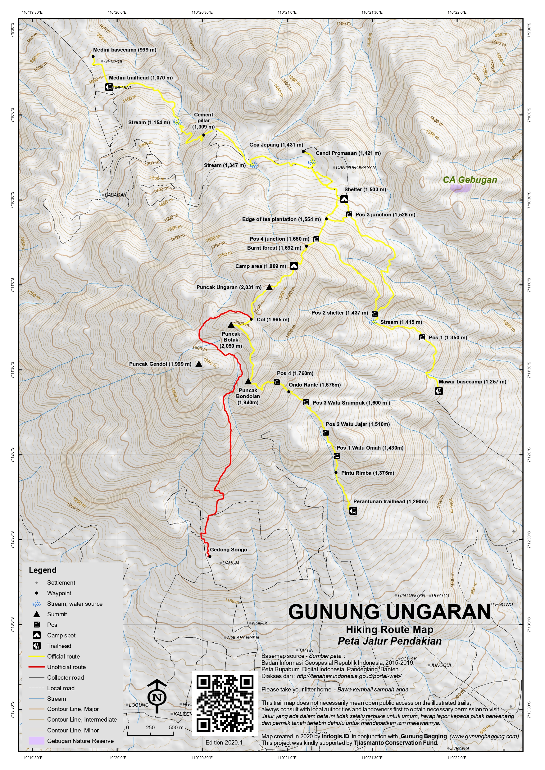
Hiking Routes (to the popular eastern peak):
Via Mawar Basecamp at Umbul Sidomukti (south-east of the peak) -approximately 5 hours return day-hike to the eastern top or 7 hours return to Puncak Botak
By far the most popular hiking route on the mountain, the Mawar trailhead starts at around 1,257m above sea level and has motorbike parking spaces, warungs, a hang-gliding spot and registration counter. The trail passes the hang-gliding (paralayang) area before reaching a shelter which is Pos 1 (1,350m). The path continues in forest, crossing a stream (1,415m) above which is a small waterfall before reaching another shelter, Pos 2 (1,437m).
Pos 2 is an important point on the trail because it is the junction between the old and new trails. If you are descending back to Mawar afterwards then it is best to go up one way and back down the other. A left turn here takes you up a newer trail which is a short-cut and leads directly to Pos 4. Continuing straight ahead, meanwhile, leads more gently via Pos 3 (the edge of the tea plantation) where you would then turn left and hike up to Pos 4. It is probably preferable to take the short-cut along the newer trail on your ascent and then go back via the tea plantation on your descent (or just return the same way).
Pos 4 (1,650m) has yet another shelter. Assuming you took the short-cut from Pos 2 then obviously here you need to turn left up towards the summit rather than left down to Pos 3 on the edge of the tea plantation. From here the trail gets much steeper and passes through an area which presumably suffered from forest fires in 2019 (1,692m above sea level). If you are lucky you will see lutung (Javan black monkey) here, especially early in the morning and if there are not many other hikers around.
Further up the steep mountainside are a couple of flatter spaces (1,889m and 1,925m) frequently used by local campers at weekends. Finally you will reach the eastern summit which is crowned by a large concrete platform with 3 monuments on it, plus a couple of other monuments nearby.
In clear weather, the views are simply stunning – particularly in the early morning you can see Sumbing, Sindoro, Merbabu and the smoking cone of Merapi lurking behind Merbabu. Just over half a kilometre to the south-west is Puncak Botak, a grassy ridge which is the true highest peak in the range.
To reach Botak from the eastern peak, follow the trail as it drops down into woodland. In 2020, there is a minor junction (2,012m) with a left turn labelled ‘Jalur Wisata’ and a right labelled ‘Gedong Songo’. We can only presume that Jalur Wisata is an infrequently and possibly overgrown trail that leads down to the area known as Wisata Alam Perantunan south of the mountain. Down this trail a short way is a sign with Lembah Jinten (‘cumin valley’).
But for the route for Puncak Botak, ignore the Jalur Wisata sign and follow the sign for Gedong Songo. Although it is not allowed for hikers to climb Ungaran from the Gedong Songo temple complex in 2020, this old trail handily leads to the col (1,965m) between the eastern monument peak and Puncak Botak although it is a little overgrown so watch your steps carefully.
From the col, you may need to bash your way up through thorny bushes a short way before reaching the grassier area, from where it is quite obvious as there is a clear trail and one or two purple ribbons along the route. Soon you will find yourself on the Botak ridge. Left leads down to better views of Rawa Pening lake (and may even continue all the way down to a similar starting point to the Jalur Wisata route on the southern side of the mountain). Right leads to the two highest knolls of the entire mountain range as described above. The views from the top of Puncak Botak are excellent and it really does deserve to be the true highest peak. The lower western peak of Gendol is clearly seen about a kilometre to the south-west, along with Dieng’s Gunung Prau and all of the higher volcanoes of this section of Central Java.
Getting back to the eastern peak with monuments the same way requires around 30 minutes.
To descend back to Mawar you can head back the same way via the short-cut between Pos 2 and 4, or if the weather is fine and you have plenty of time better still descend to the edge of the tea plantation (Pos 3, 1,526m). This is a little overgrown but you should be able to cut through to the plantation track without too much hassle. From there you can visit the nearby Goa Jepang (Japanese Cave, 1,431m) and Candi Promasan (a Hindu temple or bathing pool, 1,421m) both of which are on the edge of Promasan village.
From Pos 3 at the edge of the plantation, take a right back down to Mawar or retrace your steps to the Pos 4 trail junction higher up the mountain. There are lots of local villagers working in the plantation and at the village so be sure to ask if you are not clear on which way to go. For the former approach, following the wide stone track and looking for signs (or taking relevant GPS traks from this very website) and you should be OK, but far fewer hikers use this path than the short-cut, especially during the week!
A left at Pos 3 (on descent from the summit) takes you on a completely different route north-west through the extensive tea plantations via Promasan village and down to Medini and towards the north coast. This makes a great traverse of Gunung Ungaran in either direction but requires extra time and logistics (see below).
Via Promasan and Medini tea plantations (north-west of the peak) – approximately 6 hours return day-hike to the eastern top or 8 hours return to Puncak Botak
This trail via the Medini tea plantations (kebun teh Medini) is beginning to get more popular but unless you have your own motorbike it is a little more difficult to access (via Limbangan) and takes a bit longer than the Mawar route. The Medini basecamp is at an elevation of almost exactly 1,000m, but motorbikes and cars with high clearance could theoretically be taken along the rocky plantation tracks as far as the village of Promasan (1,430m) which is an isolated community in the middle of the tea fields but frequently busy at weekends.
In reality, most hikers leave their bikes near the basecamp or slightly further up (1,070m) near a camping area and building to rest in. The views to the north coast including the city of Semarang are impressive early in the morning before the haze arrives. If on foot, do not follow the wide tea plantation track, but rather take a left which is a short-cut to the highest slopes of the mountain. The path is pretty well marked with signs, but you need a left (1,140m) before crossing a stream (1,154m). A little higher up, you pass a cement pillar on the left (1,309m) before taking another left (1,328m) and again (1,360m).
All of a sudden you will find yourself at the tea plantation village of Promasan (1,430m). There is even a Candi Promasan (ancient Hindu temple) in the village. This area can get very busy at weekends with campers and if like many folk here you want to visit Gua Jepang then take a left for about 5 minutes. Beyond the village, through an entrance gate with YONIE RAIDER written above it (relating to local army battalion in Semarang called Banteng Raiders), and you will find yourself at a shelter (1,505m) before the very important junction at Pos 3 (1,526m). Straight on leads you gently down to Mawar. A right turn leads you steeply up to the eastern summit (Puncak Ungaran).
Via Gedong Songo temple complex (south of the peak – rarely used and no longer recommended) – currently closed (according to latest information in 2020)
The temple complex lies at 1,200m which means you get a good head start on your hike here, if only the route were not now closed. There is also a hot sulphur spring (Kawah Ijo) a little way up the hillside and plenty of warungs selling drinks and snacks. It takes about 4 hours to reach the eastern summit and just under 3 hours to descend. There are one or two places where you might be able to find a small amount of somewhat muddy water but it is better to take enough of your own supplies.
Follow the path past Gedong Songo 1 and – before you reach Gedong Songo 2 – take a right turn at the blue and orange tarpaulin-covered warungs near a sign for ‘adventure center’. (Whatever you do, do NOT head left towards the hot sulphur springs and steep rock face as this trail leads up towards Gendol, the western peak, which is totally covered in dense and spiky foliage.) The vague and slippery trail left leads up through farmland before climbing steeply and heading beneath a rocky outcrop on the left. The trail then leads into denser forest and between two of Ungaran’s three peaks.
The trail twists and turns before leading round to the right (east) and then round the base of Ungaran’s grassy middle peak, Botak. Although the trail is overgrown, at least back in 2010 there were many signs nailed to trees with ‘G. Songo’ and ‘puncak’ written on them so it was difficult to get lost when this trail was still officially open. After just over three hours of hiking along the twisting and turning paths, take a left turn which leads up to Ungaran eastern summit. If you keep heading straight on you might reach the foot of the middle grassy peak, Botak, which at 2,050m is actually the true summit of the range.
From the left turn, it takes about 45 minutes to get to the eastern summit and its many painted monuments. In good weather the panorama is fabulous with most of Central Java’s highest peaks visible. Beyond the eastern summit, you will notice a path leading up from the east – this official and popular route is used by hikers from both Mawar basecamp and Medini basecamp as detailed above.
To descend from the eastern summit to Gedong Songo, simply retrace your steps and follow the many signs for Gedong Songo. The slippery path is at times overgrown with foliage so be careful not to stray from the correct route. When you finally reach the warungs it is worth having a rest and then exploring the temple complex. The hot sulphur springs are just a ten-minute walk towards the rockface below the visible western peak Gendol.
Bagging information by Daniel Quinn, last updated March 2020. The March 2020 expedition was kindly supported by Tjiasmanto Conservation Fund.
Trail Map
For a high quality PDF version of this and other trail maps, please download from our Trail Maps page.
Practicalities
- Getting there: For domestic flights from or to Central Java, such as the airports in Semarang, Solo (Surakarta) and Yogyakarta/Jogjakarta we recommend Baolau. Basic public transport between Semarang and Bandungan is slow but readily available. Taxis will take you to Gedong Songo from Semarang but unless you book in advance it may be difficult finding one to take you back so Grab or GoCar are recommended instead. Local ojeks are available too.
- Guides and GPS Tracks: Want a PDF version for your phone? Looking for a guide? Need GPS tracks and waypoints? Gunung Ungaran information pack can be downloaded here.
- Trip planning assistance: Would you like Gunung Bagging to personally help you in arranging your whole trip? Please contact us here.
- Permits: Register at Mawar or Medini basecamp (around Rp8,000 per hiker in 2020).
- Water sources: It is best to take enough of your own but stream are passed on the Mawar trail (at 1,415m) and on the Medini route (at 1,150m, 1,350m) and you can probably find water at Promasan village in the middle of the tea plantation. Very limited and unreliable on the now closed route from Gedong Songo.
- Accommodation: Try the Booking.com map above or use this link to search for suitable hotels, homestays, resorts and apartments for your trip.
- We recommend Safety Wing as travel insurance for overseas travellers and tourists hiking up to elevations not exceeding 4500 metres.
Local Average Monthly Rainfall (mm):
Location
Click on the blue arrow ![]() (top right) to see your current location on the map
(top right) to see your current location on the map
Origins and Meaning
Ungaran is the name of a place meaning something like “new town”, “new settlement” or “a place where a new start is made”. It is likely, I think, that the town of Ungaran gave its name to the big hill or mountain looming over it. (George Quinn, 2011)
Links and References
Wikipedia English
Wikipedia Indonesia
I climbed Ungaran recently from Mawar. If going from Puncak Tugu Raiders (Puncak Ungaran) to Puncak Botak do not follow the old direct connection that is described here on this page. It is completely overgrown with thorny shrubs. Just follow the well-marked Jalur Wisata in direction base camp Perantunan until you see the junction to Puncak Botak. The trail is quite confortable.
Furthermore, there is also a Pos 5 on the Mawar trail.
Great hike up Ungaran yesterday. We did the Perantunan route, which was beautiful, fast, and easy to follow. Started from the basecamp at 7am, did a loop around all three peaks, soaked in great views of Merbabu, Sumbing, and Sindoro before the rainy-season clouds descended and we were back down at the base camp by 11am.
Simaksi is now 15K for day trippers and 20K if you camp. Cars can’t quite reach the basecamp, but you can either walk 1.3km up a steep paved road or ojeks cost 15K. Lots of warung at the basecamp if you’re hungry.
The only note I’d mention is that the trail was very very full of hikers! So we didn’t exactly get much solitude, but nonetheless the hike was lovely and is definitely to be recommended.
I had a great hike up Ungaran today. I took the Peranturan route which has been opened since 2019 according to the guys working at the ticket office at the base.
I was staying in Bandungan at the Hotel Griya Persada. The start of the trail is just a short 5 minute ride from the hotel which was great. I left the hotel at 320am and was at the gate at 325am. When I pulled in, there was a guy sleeping on the bench outside the ticket office but he didn’t even stir when I rode in. I would sort out the formalities later on when I got back.
I was on the trail at 330am. The path for the first part just follows a stone path before turning into a nice trail and then stairs. It was raining when I started and I didn’t have high hopes. The afternoon before I had hiked Andong and could not see a thing on the summit.
I reached Puncak Bondolan after a bit over an hour. The sounds from the mosques up there was quite the sound spectacle. I reckon there were 100 mosques all going off it was like a symphony. By this point the sky was starting to turn orange so I thought I’d better hurry up. The part after Puncak Bondolan gets interesting. There is a huge camp site here and there is are a maze of trails. I couldn’t find the trail in the dark but after a couple of minutes I was on the trail again. After this point there is high grass that is either side of the trail. It was wet and walking through it I was getting drenched. My shorts were soaked through.
I was on the summit of Botak at 510am around 1 hour and 40 minutes after leaving. I did see the other knoll just across the way and hiked down the ravine and back up again to that summit. From standing on the 2 summits it’s impossible to tell which one is higher. The western peak has a small boulder on the top so I took off with the drone and went as close to the top of the boulder as possible. I then flew it forwards towards the eastern peak about 50m away with all the signs on the top. It cleared the eastern peak by about a meter. I can say with 100% certainty that the western peak is the true summit. If that boulder wasn’t there though it would be impossible to pick between the 2.
I stayed on the summit for about an hour just taking it all in. The views up there are amazing and there was just one couple there who camped up near the summit.
The sun was well and truly up so I decided to go back down the mountain. I was going to make a loop but the grass was long and I didn’t want to be any more wet than I already was. It was cold on the top because I was so wet but I would soon be dying of heat as I ran down the trail. I was back in just over 30 minutes and had the formalities to clear up.
Entry was 20k and to park the bike was another 5k. They even have a souvenir shop there. Ungaran is a great mountain with lots to explore. I was planning to go to Dieng and climb Prau but my wife got sick so that’ll have to be for another trip.
According to Google Maps, there is a new route leading straight up to Puncak Botak (highest peak) from Perantunan (basecamp around 1,300m) to the south, not far from the Mawar trailhead which starts higher up but leads via the tourist peak (slightly lower).
According to Google Maps, the Pos are as follows: Pos 1 Watu Omah, Pos 2 Watu Jajar, Pos 3 Watu Srumpuk, Puncak Bondolan and then Puncak Botak.
Would make a very fine circuit from Mawar to Perantunan……
Hi Dan, just back from weekend away from Jakarta to Semarang to climb Gunung Ungaran and Puncak Botak.
Having contacted the Mawar basecamp on instagram and in contact via whatsapp they recommended to climb Ungaran and Botak starting at Mawar basecamp and descending via the ‘new’ trail Perantunan as you mentioned. According to my guide Pak Suprihiadi, the new route up the Southside which leads directly to Puncak Botak opened for public use in 2019.
I took Pak Suprihiadi’s advice and camped overnight at Mawar on Saturday 1st October (he kindly provided me a free tent for the night) at the basecamp amongst hundreds of other Saturday night campers, do not expect peace and quiet camping in Central Java on a Saturday night, if your looking for a tranquil camping experience opt for a week/school night.
Nonetheless, after some home cooked Nasi Goreng, Telor and Sosis prepared my Mas Indra and his wife from the tent pitched next door managed to get a few hours rest for the early Sunday morning start, one advantage of sleeping here: my tent was literally 10m from the start of the trailhead, so the convenience of rolling put of my tent at 330am and straight onto the trail at Mawar was worth the rowdy and noisy campsite.
Starting at 330am from around 1250m at Mawar basecamp the hike to Ungaran sumit from the east side of the gunung in darkness using a headlamp was fine, the path is clearly marked and despite light rain the previous evening just a little slippery, we arrived at Ungaran Suummit at 2031m at just after 6am, and it was great to see the sunrise from the summit with great views of Muria to the North, Merbabu, Andong and Merapi to the East and Sumbing, Sindoro and Prau – South-Easterly.
Determined to bag the highest point after a few pictures we descended down through an alipine forest a col at 1,965m and back up to Puncak Botak the highest point of the Gunung at 2,050. The 360 degree views from the flat puncak Botak are fantastic especially towards Sumbing, Sindoro and Prau. With a great view directly towards the Merbabu mountain range, Andong and the Rawa Pening a huge lake in the Ambarawa Basin, you can even see Merapi hiding behind Merbabu.
The early morning start, clearly justified, as the photo’s and views from the two summits combined with favorable weather turned out well. The hike due south via the new trail ‘Perantunan’ is well marked and the first section from Puncak Botak down descends via a dramatic mountain ridge, walking through knee high grass with Merbabu, Andonh and Rawa Pening standing tall in the horizon, a wonderful experience.
A fair amount of hikers were ascending via Perantunan on our way down so clearly the new trail is popular. We arrived at the basecamp just gone 930 am having left the Botak summit at 730am. There are lots of warungs, toilets and mandi’s to freshen up, get some food and kopi before heading back to Semarang. Really enjoyed a hot tea overlooking Rawa Pening, in the Ambarawa Basin.
A very enjoyable hike and highly recommended. For those looking for a guide based at Mawar basecamp contact their WA: 0813 288 73540
Happy Hiking 🙂
Simon Reynolds
Well, after the coronoavirus pandemic destroyed our Sulawesi plans for this period, I hastily brought forward my plans to revisit Gunung Ungaran for a proper survey of the true summit of the range that very few hikers visit – Puncak Botak.
We stayed in Ambarawa for a change, and got a Grabcar up to the Mawar trailhead at around 3am. Motorbikes are a better option as the road is narrow in places and steep but a car can make it all the way up using the more easterly road up the side of the mountain.
Rp8,000 per person tickets and we were off hiking by 3.45am. Very few other hikers as it was not a weekend. Managed to reach the eastern top in just over two hours, perfect timing for a panoramic sunrise. After a short break at the monuments, we continued on in the direction of Puncak Botak. At the Wisata / Gedong Songo trail junction, we tried Wisata first and it seemed to have been well-used recently. But after reaching Lembah Jinten, the trail continued to descend so we backtracked and followed the Gedong Songo overgrown path that took us where we wanted to go.
You need to drop down about 70 metres or so to the overgrown col at the base of Puncak Botak, before steeply ascending onto the true highest points of the Ungaran mountain range which are more than 15 metres higher than the eastern monument peak. What a lovely spot. I thought the knoll with the cairn on it was the highest point with a GPS reading of 2052m, but Rob’s GPS got its highest reading over at the second knoll where there is an old trig pillar base (part of which has fallen a few metres down the side near the path) so I have updated the Gunung Ungaran summit location co-ords as this second knoll, so that any hikers are likely to visit both just in case.
It was our plan to visit Promasan to check out the Hindu temple and the Japanese Cave so we went back down that way. We saw 4 or 5 lutung swinging through the branches near the burnt forest area (around 1,750m). It was pretty overgrown when we reached the edge of the tea plantation, with some recently fallen trees, so we had to bash our way through to the plantation track. The temple and cave were worth a visit, especially as the view of the mountain from the cave is exceptional. But be careful in the cave as there are some puddles where it is easy to get your feet wet!
Descending down to Mawar we made a bit of a mistake! We were trying to find the old path back down to meet with Pos 2, but the plantation track seemed to be leading down a bit too much in the wrong direction. We took a right near some hiking signs (many of which have no useful info on them or are so old as to be unreadable) but this was clearly a mistake as the trails either got narrower before disappearing or looked so unused that we were clearly just on a hunting trail. Rather than heading back to the plantation track, we decided to follow a very vague trail back up to meet the Mawar trail. We made it, so all was well.
When I got back home I checked another GPS route for the mountain and sure enough we turned off the plantation track too soon. If we had followed it further we almost certainly would have got back to Pos 2. But that is assuming there is a clear sign, which there quite often isn’t! So allow extra time for this descent, go with someone who has done it, or else simply ascend this route and back down the short cut.
At the basecamp we got ojeks for Rp50,000 each to the main Semarang-Salatiga road. Rob headed off to Salatiga in preparation for Merbabu the next morning and I went back to Semarang for a quick meal in Spiegel Cafe before getting the Argo Muria train back to Jakarta.
So I can finally justifiably claim to have properly bagged Ungaran. 1st time to Gendol and east peak in 2010. 2nd to east peak only in January of this year. And this 3rd visit to east peak and Puncak Botak the true highest peak in the middle of the range. I hope some of the others who thought the east peak was the highest will be encouraged to return for a quick explore of Puncak Botak as it really is a lovely spot. As always, early morning is best for views.
I decided to hike Ungaran again this month after not having hiked it for 10 years (!) and being curious about the other trails. Last time I went up from Gedong Songo and reached Puncak Gendol by mistake, thinking it was the true summit. I just about managed to get to what at the time I thought was the true summit – the eastern one with the many pillars / monuments on it. Well, it was a good thing I returned as I ended up making an interesting discovery after my hike, more of which below.
First of all the hike itself. Well, I was staying in nearby Bandungan so decided to visit Gedong Songo the day before the hike. It was Chinese New Year, but even so the traffic all the way from Bandungan to the temple complex was totally 100% jammed. Luckily i was on a motorbike otherwise it would have taken perhaps 90 minutes each way!
Sadly, Gedong Songo and the area which surrounds it has been over-commercialized yet without the infrastructure to deal with such huge numbers of people. There is a massive family attraction on one side of the road, with huge buses trying to pull in and out from a village road, and motorcyclists taking up more than half the side of the road instead of allowing traffic to flow in both directions. The usual brainlessness and selfishness that – multiplied by a hundred – turns a simple outing into a near traumatic ordeal! Gedong Songo was always popular, but now there are even more stores and lots of new ‘selfie spots’. It is far from a transcendental or deep experience, despite the stunning backdrop. Go on a weekday, and get as far up the hillside as you can and then, if you are lucky, you may find some solitude and atmosphere. Rp10,000 for locals and Rp75,000 for foreigners but you may get the local price like me if you show a KITAS or similar.
The forecast for the next day was terrible, but the rains came at night and the day turned out to be pretty good – certainly for January! Me and Ricky got ojeks from Bandungan all the way round to Medini basecamp (about 1 hour and some great views on the road to Limbangan of Sumbing and Sindoro) so we could do a traverse, dropping down to Mawar afterwards. It all went very well, with the tea plantation quite beautiful in the early morning sunlight and very clear views to Semarang city and the north coast.
There was some kind of tree planting event at Promasan and hundreds of tents. Quite surreal to find yourself in an isolated spot like that and turn the corner to find hundreds of people! By the time we got to the summit it was a little hazy as expected. Hundreds of hikers on the trail – so unlike back in 2010 when I didn’t meet anyone at the summit – perhaps so many because it was a national holiday, or perhaps because Ungaran is one of the few mountains that is not closed for the rainy season. We were up from Medini in 3 hours without any breaks. Surprised to see my GPS only giving a reading of around 2,033m – a good 15m or so below the published figure. Perhaps one of the overestimates, or perhaps my GPS was playing up for some reason, or so I thought at the time.
We made it down to Mawar in less than 2 hours as I had to get back to my hotel to check out and get back to Semarang for a train to Jakarta. No time for Candi Promasan or Goa Jepang but as it turns out I will be back later in the year….
Upon checking the Bakosurtanal map to give precise elevation figures for the three main peaks, I did a double-take when I read a higher figure for the middle peak (Puncak Botak) compared to the north-eastern peak that has the summit monuments and which everyone just assumes is the peak. A second map from 1943 confirmed Botak as the higher peak. I then rushed to see if it was possible to reach Botak from the monument peak (it is and a few hikers go there every couple of months or so). Next I looked through my old photos from when I went to Gendol peak and the eastern peak to see if there was anything from Botak to confirm I had bagged it too. Nothing. I presumably got to the monuments and thought ‘great, I’ve done it!’ like everyone else. I also checked photos of Botak from the monuments and it does look very close indeed. Too close to call, unless you have GPS readings and/or decent topo maps, both of which I do indeed now have (aside from GPS reading for Botak itself).
It may only be 15 metres but I need to head back just to confirm that the maps are correct – I think they almost certainly will be. Probably mid-November. Other folk who have done the ‘tourist peak’ but not the true peak are welcome to join me. Probably a hike from Mawar at night for sunrise at the tourist peak before an extension to Botak and back down to Mawar. I’ve claimed Ungaran as a bagged Ribu so now I need to truly bag it before the year is up! Really wasn’t expecting this but… looking forward to it already! This time a gap of ten months rather than ten years!
I’m stay in here , call me
Just did a great and straight forward hike up Ungaran from Base Camp Mawar. My original plan was to go via Gendong Songo but I was informed by my guide that the trail from Gendong Songo was either closed or going through maintenance.
From Mawar, I went at moderate pace and we were up on the summit in less than 2.5 hours. The first part is an easy and mostly flat walk through farmland and forest, before emerging into tea and coffee plantations. Finally you reach the base of the vertical face, where at a moderate hiking pace you can be on the summit in around 1.5 hours. Very leisurely if you are used to other mountain hiking in Java/Indonesia. Summit is large and flat and affords great views of other Central Java mountains including Sumbing, Sindoro and Merbabu.
Descend the same way but also do a short (30 min) detour via the tea plantations to Goa Jepang (Japanese caves) which are a worthy diversion for 10-15 minutes. After that go back up through the tea plantations and descend to Base Camp Mawar.
All in all you can go up and down Ungaran with a stop at Goa Jepang in about 5 hours. 2.5 hours up to the summit, then an hour going down to the Goa Jepang and exploring, then an hour and a half back to base camp. I started at 9am and was back by 230 or 3pm, a very easy and enjoyable day out.
Make sure to visit Gedong Songo by car after you finish at Base Camp Mawar. Very interesting temples.
One option that is apparently common is a traverse of Ungaran, presumably from Gedong Songo (assuming the trail is open) to Mawar. That would be a great option, though I’m not sure whether I would prefer starting at the temple complex or ending there.
Paul,
I plan to go this weekend with my boyfriend. Starting in Bandungan. Do you really recommend a guide? How much did you pay?
Thanks!
Sarah
Thank you Paul. I am going there the day after tomorrow. Your info is very helpful.
We climbed Gunung Ungaran from Gedung Songo on 19th July. (In Bandungan, Hotel Azaya is a pleasant place to stay.)
There is a string of warungs between Gedung I and Gedung II. The trail you want starts after the last warung; instead of following the cobbled track round to the left, keep going straight up between the forest to the left and vegetable fields to the right. Bear to the forest side and ascend steeply for 15 minutes or so before the slope eases somewhat and the trail bends gradually to the right. After about 2 hours heading northeast, you reach a flattish section at 1720m with a couple of campsites; take the right fork at the large campsite. From here, steep ascents alternate with long, flatter sections as the trail wends its way tortuously around behind Botak summit. Although some parts of the trail are overgrown, this is actually a pleasantly cool hike through the high forest, the only drawback being the difficulty of knowing how near or far away the summit actually is. After about 3h30 you should reach the junction where you can head to Botak summit to the right or Ungaran summit to the left; you cannot miss this junction as there are about 10 signs nailed to trees instead of the usual one or two. Ungaran summit is about 20 minutes further on.
Allow about 3 hours to descend and enjoy a long soak in the hot spring pool at Gedung Songo.
This hike is not particularly spectacular, but it would be nice to feel the trail was more used, given how close it is to Semarang.
I made a very big mistake on Ungaran. So beware! From Gedong Songo, the most visible peak is the western peak (Gendol) which lies above a steep rockface. I made the assumption that the peak was the summit, or at least near the summit. So I followed a trail past a little hut above the sulphur spring, past a monkey statue and a spring and round to the left (west) of the rockface. From here, a few vague paths lead up the side of the mountain. Note the word vague! I followed one which took me a couple of hundred metres up the side of the mountain before vanishing. I should, at this point, have descended and found the correct path from the warungs but instead I decided to jungle-bash my way up to the top of Gendol. This took two incredibly painful and exhausting hours. I have never seen so many spiky plants and my hands are the evidence of that! Finally, after two horrific hours for which I have only myself to blame, at the top of the rarely-visited western peak I found ancient cairns. I also looked eastwards to see a higher grassy peak (Botak) which lay beyond a huge steep drop and dense jungle. Somehow I found the energy to carry on and hacked my way down to the col. Fortunately I eventually found a good trail running between the peaks which was the one I should have been on in the first place. It led round the base of the grassy peak Botak and to a further third peak – the true Ungaran summit – lying further east. In total it took me 7 hours to get to the true top instead of 4! On the plus side, the extra time foolishly wasted in dense spiny foliage allowed me to enjoy the combination of dangdut karaoke from the many bars in Bandungan and the mega-amplified call to prayer from nearby mosques. Quite a mixture.
Never underestimate these smaller peaks, turn back if you lose the trail and always remember to take a guide! There are some remarkably steep areas on this mountain. Maybe it’s time for me to buy a GPS.
i wonder if you saw fortress at the top of gunung ungaran ? this fortress build Japaneses people back at around year 1943. this fortress was carved inside of ungaran mountain. maybe next time we can go together …