
Facts
- Elevation: 2,930 m (9,613 ft)
- Prominence: 1,356 m
- Ribu category:
 Tinggi Sedang
 - Province:
 Jawa Tengah (Central Java)
 - Coordinates: -7.5397, 110.4469
- Rating:

 (32 votes) Add your rating
 Loading...
 - Other names: ꦒꦸꦤꦸꦁꦩꦼꦫꦥꦶ
- Eruptions: 1548, 1554, 1560, 1584, 1587, 1658, 1663, 1672, 1678, 1745, 1752, 1755, 1768, 1791, 1797, 1807, 1810, 1812-23, 1828, 1832-38, 1840, 1846, 1849, 1861-73, 1878-79, 1883-89, 1891-94, 1897, 1902-13, 1915, 1918, 1920-22, 1924, 1930-35, 1939-40, 1942-45, 1948, 1953-58, 1961, 1967-1970, 1972-90, 1992-2002, 2006, 2010-2011, 2013, 2018-23
- World Ribus ID: 69106
Photos


Bagging It!
CLOSED SINCE 2018 DUE TO VOLCANIC ACTIVITY.
This Ribu is the most active volcano in Indonesia. Its name literally means mountain of fire and it is one of the world’s 16 Decade Volcanoes. It can therefore be very dangerous indeed. There was a major eruption in 2006 but nothing on the scale of what happened in October and November 2010 when a series of devastating eruptions killed over 300 people across a radius of almost 20km from the crater. Among the dead was Merapi’s gatekeeper, Mbah Maridjan, and the volcano was on a high level of alert for several months afterwards. Since mid-2011, Merapi has been relatively quiet again and it is possible to climb to the crater rim however since 2015 local authorities have been trying to dissuade people from hiking beyond Pasar Bubrah.
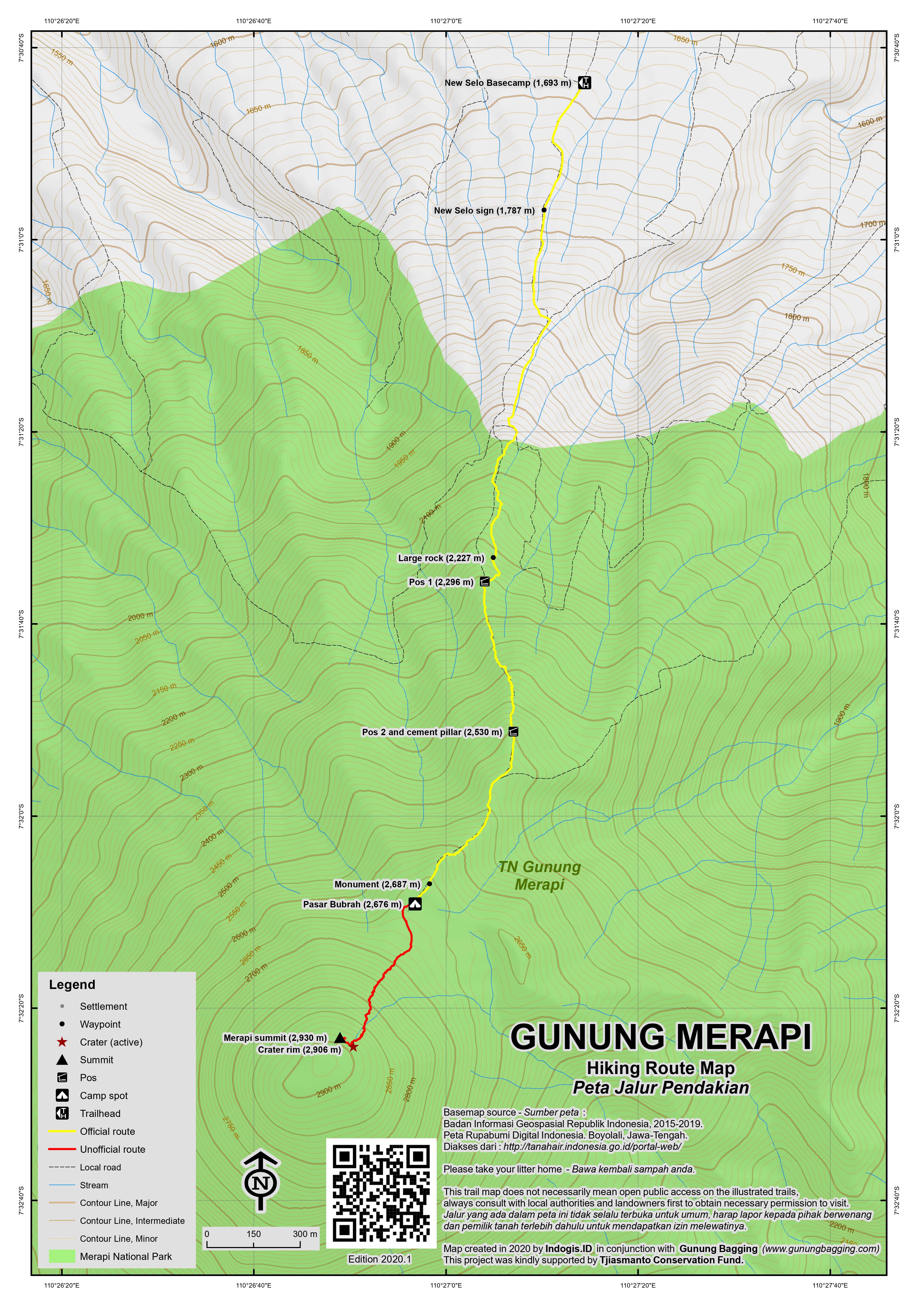
Many tour organizations offer treks up Merapi – for the best prices, check out the agents on Yogyakarta’s Jalan Sosrowidjian or proceed directly to New Selo. There are two routes to the summit area – from New Selo in the north and from Kaliurang in the south. Kaliurang is only a short drive from the city of Yogyakarta but people are banned from using this route due to it being too dangerous. Instead, the Merapi ‘basecamp’ is in New Selo. Most hikers start at midnight, or just after, in order to reach the summit area for first light. This is because Merapi generally emits more gases as the day goes on so early morning is the safest time to visit. Although there are one or two spots on the trail where it is possible to pitch a tent, there is a large, rocky campsite area, Pasar Bubrah (‘dismissed market’) at about 2,675m beneath the summit cone which has one or two monuments and some very large boulders with graffiti. This is an ideal place to have a couple of hours rest just before dawn although it is basically a huge boulder field with no grass whatsoever.
After arriving in Yogyakarta it is rather easy to find transport to the mountain village of Selo from where the actual climb to Gunung Merapi starts. A taxi can be chartered for about Rp 250,000. It is highly advisable to arrange for your taxi to pick you up the following day as it can be rather difficult to organize transportation in the mountain village of Selo. To cover the 80km from the Airport to Selo will take between two to three hours depending on the traffic.
When arriving at Selo (1,500m) drive directly to the turn off towards “NEW SELO” which is the starting point for the hike. The basecamp (1,693m) is before the end of the road on the left and if it’s late in the evening you will probably see other hikers preparing their backpacks about to set off . ‘Accommodation’ – if you need it – is simple but spacious and as in all rural areas in Indonesia very basic with few comforts. Here your own sleeping bag will guarantee a comfortable short early evening nap in the fresh cool mountain air. Guides can also be found here.
From the basecamp, follow the road up the hill for 20 minutes to the large NEW SELO sign (1,787m) next to a few warungs. This place is a very popular viewpoint for local tourists, because you can enjoy terrific views of Gunung Merbabu across the mountain pass as well as over Selo and the surrounding fertile farming area. For the first 30 minutes after the sign the track follows rather steeply through large plantations with a steep drop to your left. This small path can be very dusty during the dry season, but still offers plenty of grip on the way up.
By the time the last fields are left behind, you are close to 2,000 metres and gradually the forest trees get smaller and farther in between, and with it the surroundings offer terrific views back down the trail. As the woods get less dense the path starts to gradually get more and more rocky. Once you pass the national park sign it will take approximately 45 minutes of good hard uphill going to reach Pos 1 (2,296m) that is enclosed and protected by large boulders, and offers welcome protection from the often very strong winds.
If you are lucky to have a full moon and a clear sky then the crystal clear mountain night will unveil for you an unbelievably scenic spectacle with surreal shapes of more volcanoes both near and far, set in soft velvety clouds allowing the peaks to reach the star spotted skies. After a comfortable 30 to 40 minutes the top of the next ridge is reached and Pos 2 soon follows (2,530m).
From here the path is actually rather flat for a short 400 metres before ascending steeply to a large new memorial monument (2,687m, constructed in 2011). From here it is a five minute stroll to the middle of a huge boulder field known as Pasar Bubrah (2,676m) which is often full of tents at weekends. There are some large rocks which can be used for shelter against the wind but it is a rather exposed area and camping might be more comfortable – and warmer – lower down the trail. On the right you should be able to see the twin cones of Sumbing and Sindoro. On the left is a minor yet shapely peak which is the beginning of an alternative route back down the east side of the mountain which brings hikers out at Deles village. Most people start the final section of the climb up the volcanic cone itself at first light. It is important to remember that you should avoid being on the summit before sunrise, as on the top the shelter is non-existent and the freezing cold winds can cool your over heated body in minutes down to very dangerous levels.
Depending on recent activity you may not be allowed to progress to the volatile crater rim, especially as authorities are very concerned about the high risk, however it may theoretically be possible. From Pasar Bubrah the steep rocky cone of Merapi is clearly visible above you and it takes a difficult 45 minutes of slipping over scree – and avoiding large rocks sent down by the person in front of you! – to reach the actual crater rim. It’s a very tiring section of the trail and it’s not uncommon to see people giving up halfway. Inevitably, your shoes will also fill up with small stones and volcanic sand. As you get higher, the view becomes more and more splendid. To the left (east) you should be able to see the large mountain of Lawu towering above the clouds in the distance.
Eventually you will reach an area where you can feel that the ground gets a lot warmer and in a few areas you will pass several vents where piping hot volcanic steam is blowing out from the mountain. From this area it will take you only about 15 minutes to get to the eerie crater rim. The final 100 metres unveil an unbelievable mountain world of scree and huge shards of volcanic rock created in the enormous 2010 eruptions. The smell of sulphur can be overwhelming.
Prior to 2006, the highest point of Merapi was a huge shard of rock called Puncak Garuda. After the 2006 eruption, the highest point of the volcano was part of a new lava dome and impossible – or at least incredibly dangerous – to reach. However, the devastating eruptions in October and November 2010 led the a great change in the shape of the summit area. There is no longer a lava dome, but rather a huge new crater. Anyone who climbs again now will be amazed at the change since previous visits. In December 2012, the rim was at an elevation of 2,906m and offered tremendous views down into the 200 metre-deep and 500 metre-wide crater. Because of the amount of sulphur gas in the air which blows over the rim itself it is unlikely that you will be able to gaze southwards towards the city of Yogya itself. However, the vertical crater walls and brand new twisted crater rim are fascinating in their own right. Needless to say, extreme care needs to be taken on the rim because it is a very dangerous place quite regardless of the volcanic activity.
In October 2011, a circuit of the rim was utterly impossible but from the place at which the rim was reached hikers could walk perhaps ten or twenty metres, both left and right. If you took a left, you could climb up to a flat section of the rim which arguably offered the finest views on the rim. A few hikers ventured here in the early morning sunlight to take photos of one of the world’s most destructive volcanoes. For those intent on reaching the true summit, which was ‘baggable’ once again, it lay to the right and was a tricky and rather unsafe place to visit. For confident scramblers it was just five minutes of using all fours to clamber up to the tiny top. For anyone else, it was a considerable risk. During July 2012, further minor tremors and volcanic activity lead the crater rim to collapse in part, but the height of the current highest point of the volcano is the same as it was in 2012, since the collapsed areas were mostly lower parts of the rim. However, hikers are not encouraged/allowed beyond peering over the rim itself and it would be very risky indeed to attempt to reach the highest point.
According to GPS equipment in October 2011, the true summit was 2,930 metres high – that’s 38 metres lower than prior to the 2010 eruptions. More interestingly, the actual summit location had moved significantly – in October 2011 it was about 40 metres to the NNW when compared to how it was before. The views from the true summit were not much better than from the lower parts of the northern rim except that the twin giants of Sumbing and Sindoro can be seen. As could be expected, the scary 2011 summit had a very, very temporary feel to it – more like a horror film set about to be demolished than an enduring natural landmark! And indeed it was partially demolished in 2012 by the forces of the volcano.
After enjoying the surreal and utterly unusual landscape and beautiful views, it will take you a comfortable 3 and a half hours to get back to the large New Selo signs, which which time the warungs should be open for business and farmers should be out and about tending to their land.
Bagging information provided by Heinz von Holzen and Daniel Quinn (updated August 2017)
Merapi Museum and Merapi Lava Jeep Tours (Kaliurang)
For those who are interested in the volcano but don’t wish to climb it (or if it is closed due to activity) then it is worth spending some time in the Kaliurang area about one hour by car from the centre of Yogyakarta. At an elevation of around 800m, Kaliurang has a pleasant temperature and is a popular place to stay on weekends.
Museum Gunungapi Merapi (MGM) has an impressive selection of archive photographs and information displays in both Indonesian and English languages and about volcanoes right across Indonesia. It is well worth the Rp5,000 (local or KITAS) or Rp10,000 entry fee. The information boards suggest that the first recorded ascent of Merapi was by Van Boekhold on July 17th, 1789, climbing at night from the Selo side.
In Kaliurang, you will undoubtedly see numerous adverts for jeep tours around the villages to the east and north-east of Kaliurang that were destroyed (or mostly destroyed) in the 2010 eruptions. By 2018, this is a hugely popular trip for both locals and foreign tourists to the extent that there are several hundred jeeps available! Most jeeps fit 4 (plus driver) and you can choose between 3 or 4 different itineraries, mostly differing according to hold long you want to spend on the tour. Most tours cost around Rp400,000 in total (per jeep, 2018 price) and are both saddening and fascinating.
2-3 hours (from/to Kaliurang) is sufficient for most and includes a visit to Kaliadem Bunker (where several local people died during the 2010 eruptions and thus the bunker can no longer be used for its original purpose and is now a place for drinks and souvenirs), Batu Alien (a large volcanic boulder) and Petung Village (with cattle skeletons, photos, ruined motorcycles and other objects and a clock that stopped the moment the biggest 2010 eruption occurred on November 5th, 2010). Other stops are Kinahrejo (Mbah Maridjan’s house) and a replica of Stonehenge.
For those wishing to take photographs of Merapi from this side, the sunrise tour (starting at 0430 in Kaliurang, or 0330 back in Jogja) is by far the best option, though not all of the other sites open until mid-morning. The area around Kaliadem Bunker is probably the best spot for photos of Merapi from the south. In 2018, you can clearly see the lava dome in the crater which is steadily growing on a daily basis, and peer into one of several deep ravines created during the most devastating eruptions. No wonder that the authorities have banned people from living or rebuilding in the devastated villages as based on prior behaviour it is surely only a matter of time before another huge eruption occurs.
Trail Map
For a high quality PDF version of this and other trail maps, please download from our Trail Maps page.
Practicalities
- Getting there: For domestic flights from or to Central Java, such as the airports in Semarang, Solo (Surakarta) and Yogyakarta/Jogjakarta we recommend Baolau. Public transport from Yogya would take a long time. It is better to hire a taxi or go with a tour guide from Yogya.
- Guides and GPS Tracks: Want a PDF version for your phone? Looking for a guide? Need GPS tracks and waypoints? Gunung Merapi information pack can be downloaded here.
- Trip planning assistance: Would you like Gunung Bagging to personally help you in arranging your whole trip? Please contact us here.
- Permits: Register at New Selo basecamp for just Rp5,000 (Dec 2012) – take a photocopy of your passport photo page just incase.
- Water sources: Not available. Take enough supplies with you.
- Accommodation: Try the Booking.com map above or use this link to search for suitable hotels, homestays, resorts and apartments for your trip.
- We recommend Safety Wing as travel insurance for overseas travellers and tourists hiking up to elevations not exceeding 4500 metres.
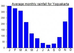
Local Average Monthly Rainfall (mm):
Location
Click on the blue arrow ![]() (top right) to see your current location on the map
(top right) to see your current location on the map
Origins and Meaning
Gunung Merapi = Firey Mountain. From the Old Javanese apuy or api or apwi (“fire”) with the prefix mer- meaning “possessing the quality expressed in the base word (like certain uses of the Indonesian-Malay prefix ber-)”. (George Quinn, 2011)
‘Fire mountain’ in Javanese/Indonesian, clearly due to its frequent and devastating eruptions. Although most nearby villages have their own myths about the creation of Mount Merapi, they have numerous commonalities. It is believed that when the gods had just created the Earth, Java was unbalanced because of the placement of Mount Jamurdipo on the west end of the island. In order to assure balance, the gods (generally represented by Batara Guru) ordered the mountain to be moved to the centre of Java. However, two armourers, Empu Rama and Empu Permadi, were already forging a sacred keris at the site where Mount Jamurdipo was to be moved. The gods warned them that they would be moving a mountain there, and that they should leave; Empu Rama and Empu Permadi ignored that warning. In anger, the gods buried Empu Rama and Empu Permadi under Mount Jamurdipo; their spirits later became the rulers of all mystical beings in the area. In memory of them, Mount Jamurdipo was later renamed Mount Merapi, which means “fire of Rama and Permadi” (Wikipedia, 2011).
Links and References
Wikipedia English
Wikipedia Indonesia
Wikipedia. 2011. Mount Merapi. Accessed from http://en.wikipedia.org/wiki/Mount_Merapi
https://joglosemarnews.com/2023/09/denise-wna-cantik-asal-spanyol-menyesal-nekat-mendaki-gunung-merapi-mengaku-kaget-karena-kondisinya-sangat-sepi/
Typical Indonesian journalist commenting on the attractiveness of the hiker!
Indonesia is still making slow progress to being an ‘information society’ where you can actually get accurate information easily, especially for tourists. It wasn’t a great idea to hike alone though.
Just got back from an attempt at the southern route on Merapi but turned around due to lack of motivation to continue.
My friends and I took the train from Cirebon and arrived at Yogjakarta station at 2.30pm. We pretty much got off the train and walked straight across the road to rent scooters at the very well places scooter shop. Indonesia is becoming a very convenient place to stay at.
We found a hotel called “hotel Shinta” up in the hills near the start of the Sapuangin trail on the SE side of the mountain. We spend the next 90 minutes navigating road closures as there were student marches going on in the city. We arrived at hotel Shinta only to be told that it was closed that night for a religious ceremony. We pleaded with the guy as there were no other accommodation places around. He still said no so we carried on. We went up the hill and found nothing so we just kept asking around if there was a losmen close by. We were told to see a lady at her house so off we went to find her.
She went off and came back saying follow me. We followed her up the road and she took us straight to hotel Shinta. We had our place for the night. After about 20 minutes speaking to her in our tarzan Indonesian she starts speaking the most perfect english an Indonesian person can speak and I was thinking what on earth is happening here. We paid the 100k per room and she proudly told us we were the first ever foreigners to stay at the hotel.
We got up at 2am and rode to the Sepuangin start point. There was not a soul to be seen so we parked the bikes and carried on. The first 30 minutes was really nice hiking before it enters the more overgrown section. We scrub bashed for the next 2 hours and at 430am, still 800m below the summit we came to the realisation that we wouldn’t get to the top before sunrise, lost all motivation in the thick, overgrown bush and decided to go back down.
All in all we made it to 2200m and had a pretty cool adventure along the way. The Sapuangin basecamp on google maps is under renovation and it seems to me that this hiking trail hasn’t been used for a very long time. There are some really amazing views to Merapi as the trail follows the ridge the entire way. There was no one around to even ask question so I’m not sure if this route will be used in the future or left to be taken back by the forest.
Hey guys! Any updates on what’s happening in the merapi/merbabu area with closures?? It is difficult to find info but it seems both are closed… Please let me know if anyone has solid info! Thanks!
hi colin, did you get any up to date info. Planning on hiking up merapi but want to make sure it is open before we plan this for our trip in September….. nzcanoer@yahoo.co.nz
There’s no way you could be sure for September until much nearer the time. Why not pencil in Gunung Merbabu as an excellent Plan B?
Hi,
Currently mt Merapi is on level 2 state, that’s mean hiking or climbing the mountain is prohibited. I saw on the news that there is some small eruption happened not long ago. You better go to Mt Merbabu which is open all the time of the year. Selo and suwanting route is popular and get crowded with hiker during the weekend. if you prefer a less crowded route you can take thekelan route from kopeng. cheers
Great weekend in the Kaliurang area. Despite having hiked up Merapi at least 3 times I had not up until this past weekend explored the area on the southern slopes. Managed to get a 2 hour sunrise jeep tour for 350,000 which I think is good value, but in Jogja on one of the backpacker streets you could probably find people to share with, so perhaps only 100,000 each. They give you a helmet but you need to make sure you hold on, especially during the rainy season when the muddy tracks change shape every couple of days and the ride will be very rough in places.
The lava dome is growing, and it will almost certainly be just another few years maximum before another big one. Very pleasant driver, who offered me some local booze that is kept in the boot of a 1960s car! This being Sunday breakfast time and it had all be consumed the night before!
Amazing how difficult map-making must be in this area. Things change every couple of years, new building are made to sell souvenirs to tourists. It’s almost like a film set.
GUNUNG MERAPI IS CLOSED!
Gunung Merapi erupted on May 11, 2018; funnily enough causing my planned May 12 hike there to be cancelled! That said, I heard from the local authorities in August 2018 that that the volcano was again open for hiking, though at people’s “own risk.” Yesterday, September 9, I had to cancelled my planned hike on Gunung Sundoro, as the mountain was closed due to a forest fire. So off I went to Gunung Merapi. There are clear closure signs at the bottom of the mountain, but I continued up. At the “Pasar Bubrah,” the area used for camping at 2,700 m there are many signs that the mountain above is closed and that one should not enter the “ballistic zone.” I suspect that there have been changes in the level of volcanic activity recently, and would certainly strongly recommend against going any further if you should visit the mountain.
The end of August, the guide told me that Merapi was closed since May 2018 due to an increase in vulcanic activity, he suggested climbing merbabu (a mountain near Merapi) and it was an amazing mountain. my guide was Sura Mendhol, he live in between Merapi and merbabu, nice guy, spoke English very well, and certified … I was very recommend Him for climbing Merapi or Merbabu.
Its his contact number (deleted)
you can contact him through whatsapp,
Or chat him on email : (deleted)
Thanks for the information!
Merapi was a great hike.
You can read up more on my detailed experience on : http://www.yonderingsoles.com/2013/12/15/merapi/
I go to Java next November,20
Is it possible to do summit in November?
I read that access to Merapi is closed in rainy season
thanks
I advice you not to go through Merapi in the rain season. I have tried to do that and it was a very difficult experience. The rain, wind, fog and slippery slopes made it unpleasant. And because of the fog, we had no view at all.
hi , my friend and i ( 2-3 pax) interested for the above climbing this year . when is the best time for the climb and how much is the price per pax . can we start the climb around 5am as we dun want to climb in the dark
Amazing view!!
I was there and it was great! We caught a window of perfect weather and it was an amazing experience. Hiking Mount Merapi for low cost traveller might be a problem, since it’s 150.000RP during weekdays and 225.000 during weekends. We paid local fee (12.000) since we have stay permit
In a few days I will attempt the climb, hopefully the weather will be suitable. I’ll see if anything is changed from your description. Thanks for such a detailed explaination.
Hi. Is there an entry ticket to pay before hiking up to Merapi?
I’ll be going up there again for the 2nd time but with more friends.
So everything went great. I was quite slow and was lagging behind my group. As this is my first night climb ever on a volcano, it took a while to orientate myself and the surroundings. I would say this is a difficult climb as it’s only my second volcano hike – the first being Gamalama in Ternate last year.
The guide and his son was great. Patient but steady. Cold winds along the way, especially when you stop for a rest. Terrain changes as you go up higher and higher – less dense forest and grew more rocky, followed by sand. Progress was slow for me but I made it to the top.
I’m not sure what time we got to Pasar Bubrah. Lots of hikers along the way and some camped. The ascend up to the summit was great but of course I was struggling. But the sunrise was great as I climbed up and enjoyed the view from the top. The wind was ok.
Overall the description on this website is spot on. Level of fitness – I think it’s a hard climb for novices but if you’ve been consistently hiking and climbing, it should be on the average or perhaps easy. I don’t know. I felt it was an intense experience due to the reputation of Merapi and being in a strange environment. And it’s all up and up all the way. Punishing!!!!
The beauty of it all is beyond words. Pictures can capture its moments but not the true feeling of euphoria, adrenaline, exhaustion and the determination to overcome. And of course in awe of an amazing yet deadly, active volcano.
Will be climbing Merapi this weekend.
In a few days should be in Indonesia and hope to trek to Mt Merapi by mid August-2014. Your blog was informative.
Update on prices and logistics:
July 2014,
In front of the turn to New Selo, there are 2 guides/guest houses: Ratri and Superman, right next to each other. Superman quoted me 300,000 IDR for sunrise guide at first, and 150,000 for a room. After much talking, he offered me 200,000 for both room and guide (i’d join with a group of 4). Honestly that was a great deal but I didn’t like the way things are run so I said no, and ended up climbing by myself early in the morning.
I met a French dad and his son at Ratri’s who paid 450,000 for room and guide. They offered to take me on their group but the guide said no, saying that there’s a maximum of 2 people/guide. (I don’t think this is true.)
If you want to spread the business out to others in town, I’d recommend a couple of places near the market Pasar Selo/ Pos Polisi (before the turn to New Selo if you’re coming from Prambanan/Solo side).
The warung Arga (right next to Pasar Selo) offers homestay. The lady owner doesn’t speak English, but if you say homestay, she’ll understand and take you to her house. It’s basic, but clean and warm, and less than half the price of Ratri/Superman.
On the other side of the road, there’s another warung. The owner, Yekti (his name is on the sign) is also a guide. He has a Merapi tour sign in Indonesian, but he can speak English. He gave me all the information I needed and lots of encouragement.
I’m seeing quite a few clicks from this site to my blog, so if you’re looking for description of my solo hike, here’s the post https://musingontheroad.wordpress.com/2014/08/08/ditch-the-guide-solo-hiking-the-mountain-of-fire-merapi/
FACTOID: Excavations of Candi Sambisari and Borobudur (construction completed 825 CE) near Yogyakarta inform that Gunung Merapi had at least five major eruptions over a very brief period between 884 and 898 CE. Historians surmise that these eruptions caused previously fertile lands to be abandoned and contributed to political instability within the Sanjaya Dynasty in the Kingdom of Mataram, Central Java, resulting in migration of the population towards East Java. The Sultanate of Mataram was only re-established under Senopati, as a Muslim principality, at Kota Gede near Yogyakarta in 1584, and continues to this day.
Hi,
I’ve just climbed Merapi this Sunday and feel great with the last condition of Merapi including enjoying the view from the true peak.
My recommendation when climb the mountain on week end don’t forget to wear a mask covering your nose, specially when it’s dry season because of the dust during the climbing and the descending.
Thank you Daniel Quinn for this informative website. I really learn a lot from it.
Cheers,
Agus F
Hi guys,
Climbed Merapi this morning, twice! – my first Gunung! So beautifil! Does anyone know what the fastest recorded time for one or two ascents is?
Thanks!
Hi Dan,
Merapi was the first gunung that I attempted. Arranged everything through Kartika Trekking in Jogja and paid 250,000 IDR. There were five of us foreigners. We arrived at the Superman Guest House at midnight but were told that we would start only at 1 am. There was very little communication so we had to sit in the living room like idiots. The guides finally introduced themselves and we were off at 1. I may have underestimated my abilities that day (after a sleepless night) so I was the lagging turtle of the group. I was probably 20 min behind the others so I had my own guide. I was about 40 minutes above pos 1 (just below pos 2) at sunrise. The views of Merbabu across the pass and the surrounding landscapes emerging from the cloud cover are definitely worth all that work. I would’ve continued slowly up to meet my group but they all came down after being told by the guide that it’s too windy at the summit. They apparently waited an hour by a huge boulder in Pasar Bubrah for the winds to die down but to no avail.
I would go back and finish the job but, knowing my abilities, I’d do a 2D1N trek, camping near Pasar Bubrah and summitting just after sunrise the next day.
For the information of future trekkers, you could just go directly to Selo village and hire a guide at the Superman Guest house (or the one next door) at the junction of the main road and the perpendicular road going up to New Selo.
If anyone has the number of the Superman Guest House, I would appreciate having it.
hi marcus. sorry to hear of your failed attempt at merapi but it sounds like you didnt miss out much since it was too windy.i also climbed merapi 2 months ago and it was borderline on too windy as well.i wouldnt like to be on that summit and be blown off so i think if the guides say its too windy then i would respect that decision.i stayed at the ratri homestay on the turnoff corner to new selo. i didnt see any other homestay named superman.i wonder it was the same one.anyway i agree that hanging around until 1.00am seems a bit presumptuous of the guides thinking that we are all as fit as them. i was also ready at 12.00 to go and they wouldnt let me start until 1.00am . i barely made sunrise and i would consider myself to be resonably fit and above average in speed.although you dont want to be sitting on the summit in the freezing cold waiting for sunrise i feel they should leave at 12.00 and then reassess on the way up how fast to go.if you are to quick then you can always wait behind one of the many large rocks at pasar bubrah.i would also push hard to get a ojek up to the new selo sign so that would save half and hour of a boring road walk.good luck on your next summit attempt.
merapi hiking to the crater is open.i climbed to the crater edge 2 days ago but not to the summit. theres a flag on the true summit and it looks oh so close but the guides wont let you go.i cant blame them.i think it would be a unreasonable risk to go up.normally id be dissapointed to not be able to put it on my bagged list but the scenery is just so amazing that you dont care.i was lucky enough to have a clear view into the crater and see glowing red lava .the track up is steep but not that long. but i wouldnt underestimate it.i would say on the night i went up there was about 8 of us and only 4 reached the top . 2 gave up just above the new selo sign because they were told by their hiking agency in yogya that its easy and only requires basic fitness level.
i stayed at ratri homestay which is at the turnoff up to new selo.they are the only place and they even say that which gives you the feeling that you have no choice and are at their mercy.im not sure what to make of the place. i met the owner soni and he has a 100 odd guides working under him. i paid Rp300,000 for my guide .he said i pay extra for english speaking.thats ok i have no problem with that. but he barely spoke a word the whole trip.
merapi is a must for any volcano enthusiast. although i still give the mount iya crater the nodd.
Thank you for the wonderful information!
I would like to hike on some of the volcanoes in Indonesia, which brought me to your website.
If I come in late Dec or Jan or Feb, which volcanoes would be hike-able?
I’m thinking of traveling in Java and Kalimantan.
Thanks!
Thanks Andy! Hi Chris, just got back from Yogya. Im supposed to climb Merapi during my stay. The tour agency, however, cancelled it because of ‘increased activity’ in the area. I asked several agencies, but they also cancelled. Though some agencies would still dare to bring tourists to the area, I decided not to climb since most said there’s a higher tendency of laandslides or erosion. Too bad for me. Hopefully Merapi behaves when you get there. Enjoy!
as i was planning my next adventure to climb all the central peaks i came across this info on the jakarta post. and also someone on lonleyplanet commented that its not allowed to hike to the summit but only to pasar burah because of the lava dome collapsing in mid july.
http://www.thejakartapost.com/news/2012/07/17/mount-merapi-spouts-ash.html
Hi all,
Just done 2M summits (Merbabu – Merapi) last week end.
Merapi: if u want to do it independent in 1 day is possible. i did 3.5 hours from New Selo to the summit, then 2.5 hours to go down (so i didn’t camp) and went up w/o guide is also possible but you have to be careful, extra careful on the sandy and slope trek (after pasar bubrah). If u need proper accommodation to have rest (like what i did after merbabu) there are 2 home stays at the main road, at the junction to the New Selo.
Merapi is quite short but tough!!!!
Hi, I’ll be in Yogya next week (August 1-5) and planning to climb Mt. Merapi. Would you remember any contact number or name perhaps of a reliable guide there?
Thanks.
Max
Have you seen our guides page? We have one guide for Merapi: https://www.gunungbagging.com/guides/
HI , i intend to go trekking in Mt Merapi then follow by Mt Semeru and Mt Bromo . Can you please advise me how to go Selo from Yog airport and also from Selo to Surabaya?
any good and reliable trekking guide or company can introduce to me ? Tks
Hi, will anyone let me know the price of trek? I am planning to trek Mount Marapi in December. Is it good time to give a try for it?
A bit confused also. which one will be better? MOunt MErapi or Mount Rinjani?
Hi Sandip
The local price for a Merapi guide is just about 150,000 (just ask at the basecamp or sort it out in Yogya) but if you arrange in advance online you will end up paying over 1 million (including transport etc..). December is not the best time for hiking in Indonesia. I would choose Merapi because you can be up and down in 8 or 9 hours whereas Rinjani is a 3 or 4 day trek.
Hi, the 150,000 guide is for how many persons?
Also, are the guides available at midnight if I choose to go to Selo at that time? Tq
Had a great trip up Merapi on Saturday night. Contrary to earlier reports, the mountain is still well over 2,900m (2,930 to be precise, as opposed to 2968m which was the official height prior to the 2010 eruptions) but the summit area is drastically altered. The summit can now be bagged but only by confident scramblers. Attempting it in poor weather would be asking for serious trouble. Luckily we had wonderful weather and there were so many locals climbing up (with it being Saturday night) that we didn’t need to bother with a guide.
Have a look at the new pictures and compare them to ones from before October 2010! Java certainly is a difficult land for cartographers – I wonder how long it will be before Google Earth revises its current (out of date) imagery and terrain data.
on 15th oct ago, i climbed this montain for the 4th times. The track along summit area is dramaticaly after last eruption changing make it more difficult to ascend although its just a short track. U’ll need your both hands & legs to keep your balance & not slip. really chalenging. the summit altitude now has decrease 200 M, become 2700 M (at 2009 ago the altitude is 2900). Just be careful if u want to climb there because the sand area is slipery & beware of rockslide.
Many thanks for this info Ricky. I will be climbing October 29/30 so I hope the weather is fine so I can take some photos of the new summit. Even if it’s 200 metres shorter now, it is still a Ribu!
you’re wellcome dan, and good luck there… dont forget to share your exprerience 🙂
wah sori mas, balesnya super telat nih. klo soal guide q ga taw mas soale q gak pernah make. coba cari infonya di base camp, ntar dibantu sama penjaga base campnya buat cari guide yang bagus.
i’ve climbed most active volcano in the world 3 times, very chalenging to hike there (esppecially after pasar bubrah). unfortunately garuda summit is collapse but we can saw lava dome there.
Mas , bisa info guide yg recommended utk naik Merapi? Saya rencana weekend ini kesana. Kalau punya no hp guide tsb tolong email saya dong..
(rhogdson@gmail.com)
Tksh.
(Suria)
Hi Zac. Merbabu will be absolutely fine. Infact I think Java Lava are doing a hike there next month.
so any word on whether climbing Merbabu is a safer option perhaps even from Selo? any feedback would be appreciated. 🙂 I plan on doing Mrbabu, Sumbing and Sundoro in about 3 weeks.
According to today’s Globe, people are already climbing Merapi again.
http://www.thejakartaglobe.com/home/tourists-risk-lives-climbing-deadly-volcano/426962
Boyolali, Central Java. Dozens of Indonesians and foreign tourists are putting their lives at risk by climbing the Merapi Volcano, a rescue worker warned on Sunday.
Samsuri, from the village of Lencoh, said on Sunday that signs warning of the dangers of climbing the dangerous volcano remained in place after the recent deadly eruptions but were ignored.
Muh Sony, a travel guide who escorts climbers, said dozens of tourists, including 25 foreigners on a science expedition, had climbed the volcano in the last two weeks alone.
He said local tour guides were always willing to escort the climbers, particularly foreign tourists, because of the money they received.
Surono, head of Indonesia’s Volcanology and Geological Disaster Mitigation Agency (PVMBG), said lahars from the volcano would remain a threat for the next four years.
Merapi, among the world’s most active volcanoes, began erupting on Oct. 26, 2010, and continued until mid-November.
Some 350 residents were killed by the pyroclastic flows that spewed down the slopes of the heavily populated mountain.
It sounds as if Merapi is beginning to quieten down a little bit, comparatively speaking, but the death toll from the devastating October/November eruptions has reached 250 now.
http://www.thejakartaglobe.com/home/indonesia-volcano-death-toll-passes-250/406548
It sounds like Merapi is about to blow. I hope to get some photos from the top of Sumbing next weekend…
http://www.thejakartaglobe.com/home/mount-merapis-swelling-signals-huge-eruption-scientists-warn/403039
All hiking routes closed at present due to increased volcanic activity. Could there be a big eruption due?
http://www.thejakartaglobe.com/home/eruption-threat-closes-mount-merapi-to-climbers/398206
An article on Mount Merapi’s ‘Gatekeeper’….
http://www.thejakartaglobe.com/home/mount-merapis-gatekeeper-wants-volcano-to-breathe-gently/393470
BIG NEWS! Garuda’s Wing (the highest slab of rock on the volcano before the 2006 eruption) has collapsed. Here’s a ‘google translation’ of the news story….
* Magelang, CyberNews. * The series of tectonic earthquake that occurred helped Sumatra
affects the activity of Mount Merapi. One of which was the peak of Mount
in Kabupateng, Boyolali Magelang, Klaten and Yogyakarta, namely, peak
garuda, collapsed.
“The collapse of the towering rock like an eagle on the summit of Mount Merapi
also a result of tectonic earthquake shocks that occurred recently in
various regions in Indonesia, “said Mount Merapi Repiyo Observer Staff
in Post Ngepos, District Srumbung, Magelang regency.
One of which SR 7.2 earthquake that occurred in Aceh some time ago,
according to indirectly affect the avalanche of material from the top.
After the earthquake earthquakes occur every day, both volcanic and
tectonics.
“Puncak Garuda fragile after the eruption began in 2006 and then, after that material
rock fall little by little, “he said.
Based on deformation monitoring, advanced Repiyo, the volcanic activity
not show significant improvement. Lava and smoke
solfatara which rises to a height of 400 meters, still in
fairness.
“Nevertheless volcanic lava dome material in 2001 and 2006 his condition was not
stable. But that was not dangerous because there has been no increase in activity, ”
he said.
Solfatara a high smoke soaring in the sky, he continued, not
affect the status of the mountain, because of thick smoke discharge is part
of the signs of the mountain was still active. However, he hopes
community activities around the slopes of Mount remain vigilant, because the
natural conditions can not be predicted accurately.
This is the first volcano I had ever climbed. You will smell of sulfur when climbing this mountain.
In this mountain you also can enjoy the sunrise and sunset.
when you wanna go to the top of this mountain, please be careful when relying on the rocks, stones sometimes are not strong enough when you step on it.
This moutain gives you more bang for your buck in half the time.A challenging trek, but also an otherwordly exotic doomsday heaven.A real treat for the eyes.The moutain is just as much about the experience as it is making the summit.Should only take one day from Basecamp at SELO.