
Facts
- Elevation: 1,825 m (5,988 ft)
- Prominence: 623 m
- Peak category:
 Spesial
 - Region:
 Peninsular Malaysia
 - Malaysian state: on the border of Selangor and Pahang
- Range: Banjaran Titiwangsa / Main Range
- Coordinates: 3.7375, 101.6512
- Rating:

 (2 votes) Add your rating
 Loading...
 - Other names: Sometimes spelt ‘Semangkuk’ or ‘Semangko’.
Photos


Bagging It!
Despite Semangkok’s relatively modest elevation, and the relatively high starting point (approximately 1,312m), this is one of Peninsular Malaysia’s most challenging trails. Meaning ‘a bowl’ in Malay, the name amusingly sounds like ‘valley of death’ in Chinese, and indeed does feel like descending into a bowl or valley from one side of a bowl and emerging, exhausted, at the other higher side of the bowl before heading all the way back again.
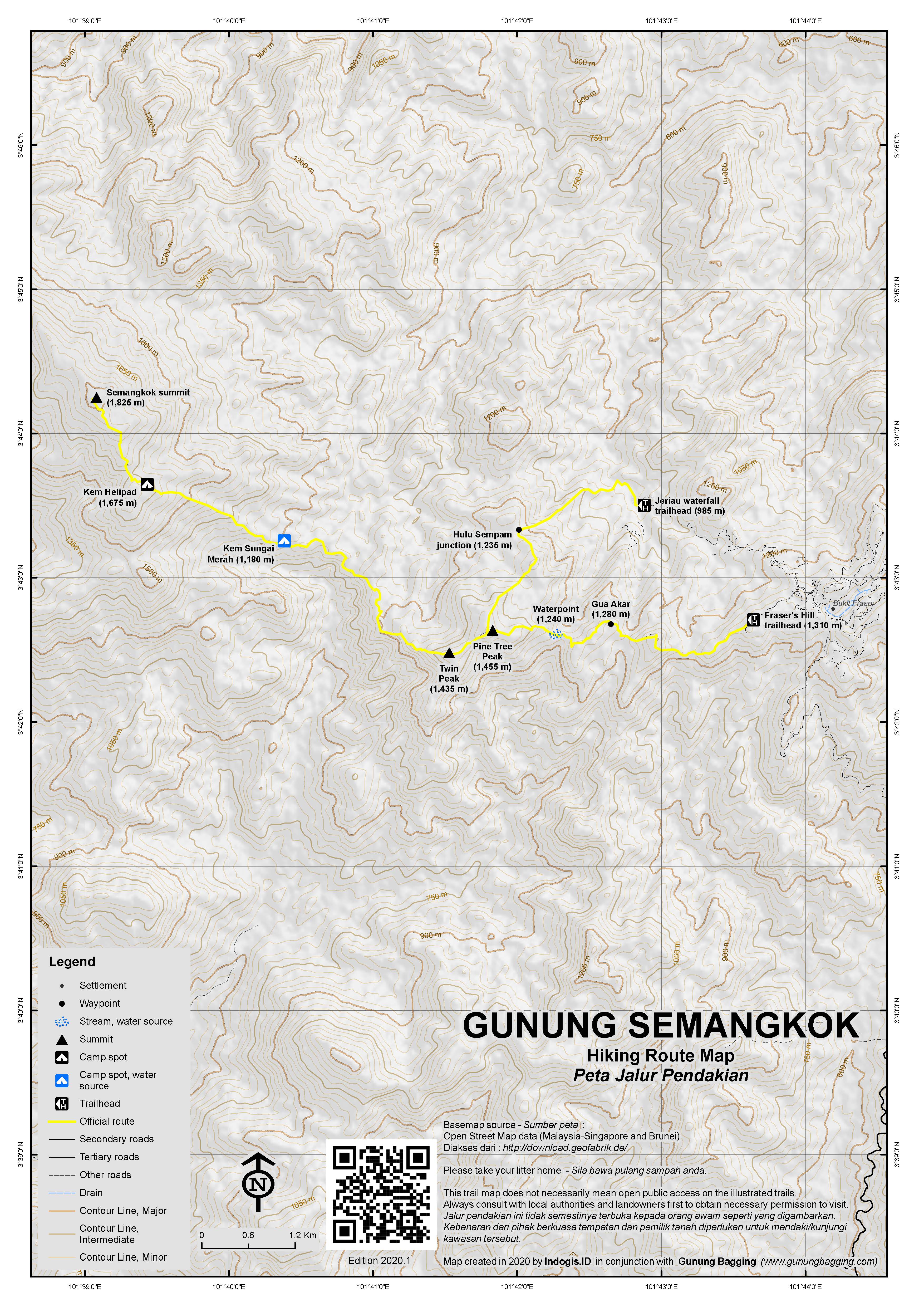
The trail is around 32km return and starts at Pine Tree Trail on the edge of the old British colonial era hill station of Fraser’s Hill (Bukit Fraser). This is a fascinating spot, especially for British tourists who will feel like they have walked onto a film set of a movie depicting English village life a century ago. It’s a popular area with birdwatchers and even if you don’t do the Semangkok hike this is a unique spot that rewards those patient enough to deal with the narrow, winding one-way road that leads up there from Simpang Gap (and down again via a different one-way route).
Fraser’s Hill was named after Scotsman Louis James Fraser who established a tin mining community in 1890 initially known as Pamah Lebar. The mining didn’t last long and Fraser returned to the UK in 1910 before dying whilst travelling in Europe in 1916. However, in 1919 work began to turn the area into a resort due to its cool climate and it opened to visitors three years later. In the early 21st century, the population of Bukit Fraser is around 1000, and is informally known as ‘Little England’. The place relies heavily on tourism and there are 3 or 4 hotels, several restaurants and a couple of apartment complexes.
There are several trails in and around Fraser’s Hill, of which Semangkok from Pine Tree Trail is undoubtedly the toughest. Unfortunately, in 2023 local forestry have been putting up ‘keep out’ signboards which leads to confusion for many tourists who have also seen the tourism signs in the area promoting the very same trails. It’s a similar story in Cameron Highlands, and the best advice is to make sure you have an official guide with you who knows the latest administrative procedures.
The summit does not offer any views so the best places for panoramic photos are actually at Pine Tree Peak and Twin Peak. Some folk try do indeed to do this as a ‘dayhike’ in 18-20 hours, but it is much more sensible to camp at Sungai Merah. A typical itinerary involves starting before dawn at around 2am or 3am, reaching Pine Tree Peak and Twin Peak for photos at first light, continuing all the way to the peak before descending again to Sungai Merah. On the second day, hike out from Sungai Merah returning the same way – or alternatively descending to Jeriau. Given it takes 8 to 10 hours one-way, the first day is very arduous and tiring. There is a lot of up and down so the return leg normally takes almost the same amount of time as the ‘ascent’. And for those not keen on bagging Semangkok peak, a more leisurely hike to Pine Tree Peak and Twin Peak is a great option for a less strenuous dayhike though you still need a guide.
Just before the end of road about 1 kilometre beyond the Fraser’s Hill food court area, the trail leads from the obvious Pine Tree Trail entrance via a memorable staircase (1,243m) that is utterly exhausting on the way back out, a tree that you can shelter beneath known as Gua Akar (1,269m), Pine Tree camp (1,220m), and then some very steep ropes and ladders (1,410m) up onto Pine Tree Peak (1,455m with a promience of approximately 356 metres). This is a good spot for sunrise but if you set off at 2am you may be a bit early for it. A better view in general is to be found at Twin Peak, about another 40 minutes onward and roughly 4 hours in total from the trailhead.
Shortly after Pine Tree Peak, you may notice on your right the Jeriau trail junction (1,406m) which leads down to Jeriau waterfall (985m) via Hulu Sempam junction (1,235m). The waterfall is currently closed but it is possible to descend to on the way out if you have someone willing to pick you up there or are keen on hiking back up to the centre of Bukit Fraser afterwards. Beyond this you will reach a pleasant opening which is Twin Peak (1,435m). This is the best place on the entire trail to admire the view, including of Semangkok itself. There is also a good phone signal here. One of the many Selangor-Pahang boundary markers on the trail is located here.
The trail then drops down into the bowl, several hundred metres down via Pacak Tepus (1,192m) and a wildlife camera (1,140m) to Kem Sungai Merah (Red River Camp) at around 1,180m. This is the place to leave your camping stuff set up and have a quick snack and wash before bagging the peak on Day 1.
The trail leads up again via a very mossy boundary marker (1,362m), Kem Helipad (approx 1,670m), another wildlife camera (1,700m), the flag peak and army pillar (1,824m) just a few metres before the true peak which is a tree with some summit signs on it in the middle of the mossy forest landscape. After admiring the summit vegetation, you need to descend the same way to Sungai Merah camping area, hopefully arriving before dark for a good, long rest before heaing back out on the challenging second day.
And for those keen on something extra challenging, this hike can actually be combined with Gunung Liang on a multi-day expedition known as Semaliang. This is a major expedition which is rarely undertaken and usually overgrown so finding a suitable and willing guide is not easy.
Once well-rested, if you are keen to do more in the region, see also Ulu or Hulu Semangkok, to the south of Bukit Fraser, which makes a great half-day hike. At 1,394 metres this peak has a prominence of approximately 535 metres , good views, and a yellow beirut at the top. It is commonly hiked via Gunung Gap (1,183m) so you get two peaks from the price of one. The trail leads from the Gap trailhead next to some old wooden parking sheds on the main road (863m) via Gunung Gap (1,183m), a point known as halfway (1,242m), Ulu Tranum view (1,329m), an undistinguished peak with very little prominence known as Ulu Tranum (1,332m), Ulu Semangkok viewpoint (1,392m) and then the summit (1,394m). Gunung Gap has a cement trig pillar and some views but the Ulu Semangkok summit views are even better. It’s a nice trail, straightforward and with a few bits of rope for the more challenging sections but mostly can be considered a trail that is suitable for beginners. There are Selangor-Pahang state boundary markers here too but not cement posts as on Semangkok.
Bagging information by Dan Quinn (August 2023)
Trail Map
For a high quality PDF version of this and other trail maps, please download from our Trail Maps page.
Practicalities
- Getting there: For Malaysian domestic flights and flights within Southeast Asia, for example to Kuala Lumpur, we recommend Baolau. The trail starts in Fraser’s Hill which is about 2 hours from KL. Public transport is almost impossible here so hiring a car is by far the best option.
- Guides and GPS Tracks: Want a PDF version for your phone? Looking for a guide? Need GPS tracks and waypoints? Gunung Semangkok information pack can be downloaded here.
- Trip planning assistance: Would you like Gunung Bagging to personally help you in arranging your whole trip? Please contact us here.
- Permits: You can register and pay for an e-Permit online from the Forestry Department of Malaysia website though you will need an official guide with you. RM10 for locals and RM30 for foreigners (in 2024).
- Water sources: Available at a difficult to spot location around 1,240m between Gua Akar and Pine Tree Peak and – much better – at the lovely river at Kem Sungai Merah (1,180m).
- We recommend Safety Wing as travel insurance for overseas travellers and tourists hiking up to elevations not exceeding 4500 metres.
Local Average Monthly Rainfall
Location
Click on the blue arrow ![]() (top right) to see your current location on the map
(top right) to see your current location on the map
It was nice to have some company for this hike, not least because it is an expensive one, with locally set fee per hiker and with a minimum group size of 7. Of course if you are a smaller group you can still do it but you need to pay as if there were 7 people. And it differs a little bit depending on whether you are local or foreign. You’ll need to check with your official guide on the latest cost but this is probably not one to do just as one person plus guide.
I arrived at Bukit Fraser (Fraser’s Hill) a bit early as I wanted to explore the area. It is like stepping onto a film set from 1930s Britain and has been well-preserved by the authorities. The temperatures up here are 1,250m or so is just delightful and it’s a very popular spot with birdwatchers too. There are many trails around Fraser’s Hill, but quite what is going on with permission to actually go for a walk on them is unclear, at least for Pine Tree Trail, the most challenging of the trails on offer, which currently has Pahang forestry signs erected just beyond the trailhead saying ‘do not enter’.
We got started at 2am, leaving our 2 cars parked opposite Pine Tree Trail entrance. There is enough parking on the verges here for 8 cars or so, but do be careful not to leave you car half on the road blocking other vehicles. There’s a ‘Malaig Bungalow’ nearby, a building named after one of western Scotland’s nicest place, presumably because one of its British residents was from that area or loved the area.
It took us 4 hours, going at a moderate pace, to reach Twin Peak. If you want to see the sunrise, Pine Tree Peak is apparently better, but for a general view over the mountains and to Semangkok itself then keep going as far as Twin Peak. We should have set off at 3am really, as we had to wait over an hour before the sun did actually emerge. Great view though, and lovely sounds of gibbons in the surrounding forest.
It then took us 2 hours down to the Sungai Merah caming spot which is lovely but but has a sandflies issue, rather like the midges you would encounter in Mallaig, Scotland, funnily enough. But we had a relaxing hour or so before keeping on going up to the peak, which took 2hr45min. Our guide spotted signs of a tapir. There’s obviously no view up at the peak but the mossy forest is certainly atmospheric.
We were back down in 2hr15min. A fair long day, but it is a good idea to get the peak bagged on day one rather than day two. Some hikers do this as a very long 18-20 hour dayhike, which does mean you don’t have to carry a tent, but all of the ups and downs are really challenging.
They are challenging enough if you split it into two days. We made it up in 2hr10min to Twin Peak but i was already frustrated, knowing of all the ups and downs still to come. There is a good phone signal here though, so I read the news!
We were hoping to head down to the Jeriau trailhead but our guide could not get us a pickup in Jeriau to take us back up to the centre of Fraser’s Hill, so I was not keen on that idea as it meant a long descent to Jeriau and then walking back up a road. So we split up, 2 of us back the same way to the cars and 2 of us down to Jeriau (they had done it before so knew the trail, the junction of which is not marked very clearly at all). It sounds like the waterfall was closed during Covid and the authorities are not that keen on re-opening it unless a private compnay wants to take it over, or so goes the rumour. A sad situation. So it means for now that you are not allowed to visit the waterfall or hike up from there, but it is still permissable to descend there on your way out.
The cement steps not far from the beginning or end of the Pine Tree Trail are emotionally draining to see on the way out. This really is a hike not to be underestimated. Strangely, when we reached the trailhead and cars, there was a 4WD from Pahang forestry and 2 guys standing around, looking suspiciously at me. I guess they were checking permits. They didn’t say anything to me but the atmosphere was a little odd and tense. A western couple, obviously tourists, walked past on the road, as tourists do in this area, and the forestry guys stared at them, as if they were not happy with their presence. It was utterly odd and a manifestation of the tension between the tourism authorities who want to encourage tourists to walk around here and enjoy themselves, and the forestry department who don’t seem that keen on tourists or hikers.
The next day i did Ulu Semangkok, similar name but totally different trail, and an easy one… just a morning hike really, starting from some sort of old wooden shed on the side of the road at ‘The Gap’. We were up in 2hr15min and down in 1hr30min. This used to be very popular but now that hikers are forced to get a permit and hire a guide it is not as popular as it once was. There are some good views up there and a nice yellow beirut at the top!
I then drove round the the bamboo-fringed road to Kuala Kubu Bahru (KKB) for a night in a local hotel before hiking Bukit Kutu. There was a big Hindu festivity going on just before entering KKB, and all traffic was being forced to effectively drive right through this event!
A Gunung Bagging trip to Gunung Semangkok is likely to happen 28-29th July 2023. If you are interested in joining please reply to this message ASAP or contact via the contact page. Thanks, Dan.
Hi, the permit application you attached is for research purpose. May I know can we also pay for that or? How can we get hiking permit to Semangkok?
Hello there. Check the links menu bar – Forestry Dept of Malaysia