
Facts
- Elevation: 1,933 m (6,341 ft)
- Prominence: 1,020 m
- Ribu category:
 Kurang Tinggi
 - Region:
 Peninsular Malaysia
 - Malaysian state: on the border of Perak and Pahang
- Range: Banjaran Titiwangsa / Main Range
- Coordinates: 3.8025, 101.5920
- Rating:


 (6 votes) Add your rating
 Loading...
 - World Ribus ID: 68713
Photos


Bagging It!
The closest Ribu to Kuala Lumpur, Gunung Liang is still reasonably quiet and peaceful, with most hikers preferring the more famous and taller peaks over 2,000 metres. This is a positive thing, because the forests are teeming with life and you are quite likely to see hornbills and hear siamangs for a good portion of the trek.
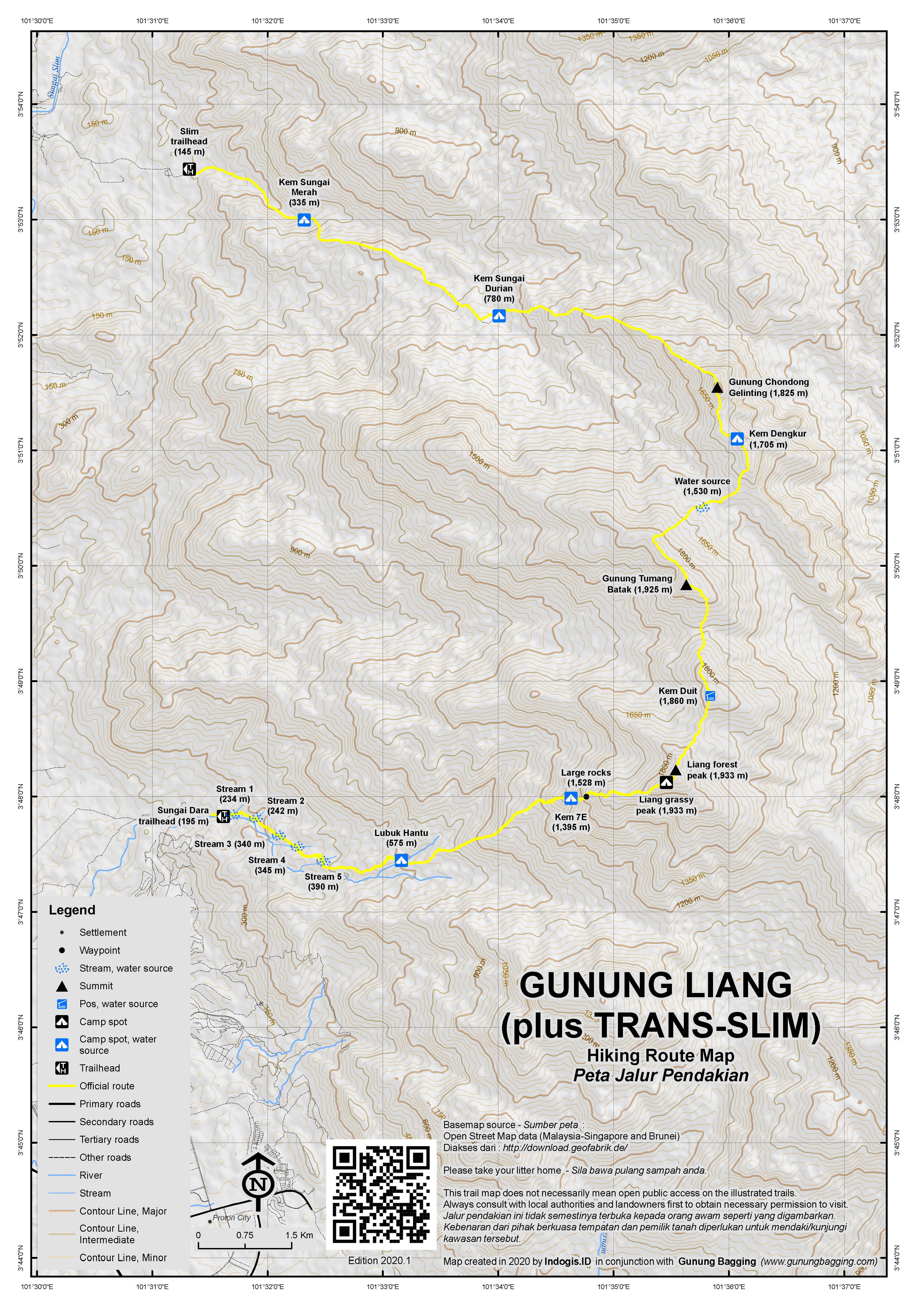
It takes most fit hikers about 5 hours to reach the peak, and a little less to descend. The trail length is around 9km one way. The starting elevation is very low, so you need to ascend around 1,730m and back down again, making this a very strenuous undertaking, especially if you plan to do it in one long day.
The trail starts at the end of the road (195m) leading up from the sign for LRA Sungai Dara. At the very end of the road there is a locked entrance to a dam on the river. There are very few residences here, so finding a guide at the last minute would probably be very difficult. Luckily, if you are with friends you shouldn’t have too much difficulty navigating the trail once you are on it.
Take a left just before this up onto a rock. From here the trail is pretty obvious as it cross over five streams (234m, 242m, 340m, 345m and 390m) in pleasant forest with meranti (Shorea) trees. The final two stream crossings are very pleasant indeed and quite large meaning you might get your feet wet after heavy rain when these streams turn into rivers! It should have taken you around 45 minutes to reach the fifth and final crossing.
From the fifth stream, the trekking is pretty pleasant and not especially steep for the next hour before you reach Lubuk Hantu (575m) which is the first of the main places to camp. You may meet a few leeches on the trail, but during drier weather you have a reasonable chance of avoiding contact with the small number you do encounter.
There is plentiful water here at Lubuk Hantu – indeed you need to cross the river so take care as in 2019 this involved clambering over the branches of a fallen tree through which it was difficult to see where to place your feet safely. Most hikers will have reached Lubuk Hantu in between 90 minutes and two hours in total.
The name allegedly comes from an incident several decades ago in the 1970s or so when some local people saw an apparition of a man dressed in a fine suit on one of the rocks next to the river!
After Lubuk Hantu, the proper ascent begins up to the next camp spot which is Kem 7-E / 7-Eleven (1,395m), apparently named after a plastic bag from the convenience store of the same name left at the same spot when the trail was first becoming popular. Previously it was known as Kem Permatang (‘ridge camp’). It will have taken most hikers 4.5 or 5 hours to reach this point.
7E is probably the most popular camping spot on this trail, as it is less than 2 hours from here to the top of Gunung Liang and this is also the last point for water (down 2 minutes to the left of the trail). However, do note that the ground is not especially even, with plenty of tree roots, so in terms of comfort Lubuk Hantu is probably better.
From 7E, the trail remains steep in places, but there are some very shapely boulders above 1,500m elevation which are simply asking to be photographed. At around 1,640m, you find yourself on what feels like a ridge and indeed the landscape changes with narrow bamboo and then mossy forest with an autumnal feel thanks to all the fallen leaves. A little further on at 1,790m, there is a fine view down to the right south-west towards Gunung Behrang (considerably lower than Liang at around 1,510m but being the closest hill in the range easier to distinguish from nearby Tanjung Malim).
After a bit of mild scrambling over steep tree roots you will suddenly find yourself at Gunung Liang’s grassy peak. If the weather is clear you should be able to see all the way down to Proton City, home of Malaysia’s national car, on the outskirts of Tanjung Malim and to other hills in the immense Titiwangsa range on the other side. Look out for a particularly beautiful species of Nepenthes (pitcher plant) here.
As you will see, the surveyor’s beirut (large metal object used in mapping many decades ago) has toppled over and in poor weather perhaps 3 hikers can shelter here from rain. Gunung Liang is quite unique in that it has two peaks of a very similar height both of which have a beirut. To visit the second, drop down a little way before re-ascending to the north-eastern top which doesn’t offer views but is exceedingly pleasant too, with the huge still-upright beirut framed by gorgeous forest ambience. It is only five minutes beyond the grassy peak.
There are several questions regarding both the correct names and correct heights for these two different peaks. The Malaysian hiking community mostly seems to regard the grassy peak as Liang East (Liang Timur) and the forest peak as Liang West (Liang Barat). However, if you look on a map or check your compass it will be perfectly clear that the western top is the grassy one as the Sungai Dara trail comes up from the west and it is the grassy peak that is first reached. That means that the easternmost peak is actually the forest peak.
One or two personal websites – whilst not specifically mentioning this confusion – have listed the grassy peak as Liang West and the forest peak as Liang Timur simply because of the geography. This makes sense and is quite contrary to most of the signs at the top, although a number of these seem to have been moved back and forth and some have fairly inaccurate altitude figures written on them anyway.
Looking at an old colonial-era map from many decades ago, Liang East is clearly the name given for the mountain peak, but it is not at a scale that you could use to deduce which of the two peaks it is referring to. It is not impossible that Liang East was the name given to distinguish the mountain not from the other top just 5 minutes away but another more distance Liang. Or perhaps from a certain angle one top ‘appears’ to be more eastern than the other when it actually isn’t. After all, in the UK there are several similar examples of ‘Big Something Peak’ or ‘Great Something’ actually being lesser to another mountain of a similar name without the Big or Great prefix. There are also examples of, for instance, north peaks being less north than a peak called the East Peak.
So, it could be from an old mapping or naming error, or it could simply be that local hikers have moved the signs around but in short what most hikers call Liang East peak is further west than the one they call the West peak. The real eastern peak is the forest one.
As for which of the two is the highest, they are so close it is impossible to be certain with a GPS. Various sources state that Liang East is the highest, but do they mean the peak with the most signs with East written on them or the actual easternmost of the two peaks?
For what it’s worth, I got the highest GPS reading (1,935m) at the forest peak but it fluctuated and was not stable. I would obviously recommend that hikers make sure they visit both peaks, especially as they are so close to each other and so different in atmosphere. I would also recommend that local hikers re-name the tops ‘grassy peak’ or ‘puncak rumput’ and ‘forest peak’ or ‘puncak hutan’ to try to put an end to this east and west confusion!
I’ve given the summit co-ordinates on the relevant files as being at the forest peak because most folk will hike up from Sungai Dara so it is better they continue to the forest peak beyond the grassy peak rather than turn back 5 minutes prematurely.
Some hikers do this trek as a long day-hike, starting no later than 7am and taking around 6-7 hours up and 4-5 back down plus breaks. It is a considerable elevation gain from around 200m all the way up to over 1,900m and back down again in the same day but it can quite easily be done by confident and experienced hikers.
The disadvantage to the day hike is that as per usual there tends to be a lot of cloud around in the middle of the way so views are not likely to be as good as if you are already up at the top by 9am. Ideally you want to be heading down by 2pm if you are planning to get out the same day before dark.
Some local hikers who spend a night or two in the forest continue beyond the forest peak via Kem Duit (1,860m) to Tumang Batak (1,925m), typically spending two nights at 7E. This is a considerable extension, taking around 5 hours return from Liang forest peak, and to a peak that is slightly lower than Liang and has only limited views.
You can also do a full traverse known as Trans Slim and come out somewhere near Slim River (145m). This long multi-day expedition trek leads on from Tumang Batak via Kem Dengkur (1,705m), Gunung Chondong Gelinting (1,825m), Kem Sungai Durian (780m) and Kem Sungai Merah (335m). Water is supposedly available at all of the Kem/camps but you will probably need an experienced guide to locate some of the actual water sources.
The other – even more extreme – option is trying the new trail cut between Liang and Gunung Semangkok. It takes around 3 days from Liang forest peak, taking a right and following the ridges.
Bagging information by Dan Quinn (July 2019)
Trail Map
For a high quality PDF version of this and other trail maps, please download from our Trail Maps page.
Practicalities
- Getting there: For Malaysian domestic flights and flights within Southeast Asia, for example to Kuala Lumpur, we recommend Baolau. The trailhead at the end of the road at Kampung Sungai Dara, Behrang Permanent Forest Reserve is only about 1.5 hours by car from Kuala Lumpur. Tanjung Malim is the closest train station if coming from the south. In 2019, there are plenty of trains and regarding last trains, there is a northbound train leaving KL around 2305 and one returning south arriving KL again around 2000. The road junction has a signpost for LRA SG DARA (LRA Sungai Dara). Public transport is not suitable and Grab does not yet exist in Tanjung Malim so a taxi with arranged pick-up is perhaps the best option if you don’t have a car.
- Guides and GPS Tracks: Want a PDF version for your phone? Looking for a guide? Need GPS tracks and waypoints? Gunung Liang information pack can be downloaded here.
- Trip planning assistance: Would you like Gunung Bagging to personally help you in arranging your whole trip? Please contact us here.
- Permits: You are supposed to arrange in advance with Pejabat Hutan Daerah Perak Selatan (Tapah) but if you have a local guide they should be able to take care of this. Estimated cost RM10 per local hiker and RM30 for foreigners. You are encouraged to report at Behrang police station the day before your hike to let them know your plan. You can register and pay for an e-Permit online from the Forestry Department of Malaysia website.
- Water sources: Available at Lubuk Hantu (575m) and 7E (1,395m).
- We recommend Safety Wing as travel insurance for overseas travellers and tourists hiking up to elevations not exceeding 4500 metres.
Local Average Monthly Rainfall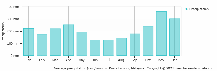
Location
Click on the blue arrow ![]() (top right) to see your current location on the map
(top right) to see your current location on the map
Do we need a guide to Gunung Liang? If yes, can you assist how to get a guide? Thanks!
After coming back from Gunung Batu Putih and doing a little online research, I came across The Jungle Is Neutral – an autobiography by F Spencer Chapman, a British lieutenant in Malaya during Word War Two. He spent several years evading the Japanese in the hills of Malaysia and includes the following mention of Gunung Liang, the col towards Semangkok, and navigation here in general:
“Next day was purgatory. We wasted half a box of matches before we could persuade the sodden bamboo to light; then it started to rain again and we gave up the attempt to dry our clothes. We now climbed out of the river valley and set a course due west, making for a col half-way between Gunong Liang (6,341 feet) and Gunong Semangko which, at 3,985 feet, is the lowest point in that section of the Main Range watershed.
I was now to learn that navigation in thick mountainous jungle is the most difficult in the world – and I had always rather fancied myself at map reading and finding my way in all types of country from Greenland to Australia. In the first place it is quite impossible to find out where you are on the map: the limit of your visibility is fifty to a hundred yards, and even if you are on some steep hill-side, where a small landslide has opened up a window through which you can catch a glimpse of another steep blue tree-clad hill-side, you are none the wiser, as one hill is exactly like another. There are no landmarks – and if there were, you could not see them. Another difficulty is that there is no way of judging distance: it took us more than a week to realize we were taking eight hours to travel one mile on the map instead of the three or four miles we we imagined, judging by the amount of energy we were expending. Perhaps the greatest impediment to navigation is that, having decided to move in a certain direction, you are quite unable to do so owing to the difficulties of the terrain; we were continually forced off our course by swamps, thickets, precipices, outcrops of rock, and rivers. its was impossible even to follow a ridge unless it was very steep and clearly marked. With such limited visibility it was seldom clear which was the main ridge and we soon found ourselves down in the valley bottom, having inadvertently followed a subsidiary spur. In the end I found it best to follow the line of least resistance as long as we worked steadily westward; but we very soon had absolutely no idea where we were on the map.”
Back in Jakarta from a very pleasant weekend near KL. Flew to KL straight after work on Friday. A fair amount of delays with taking off and then finding an empty gate, meaning I had to run to get the airport express train to Sentral in order to make it in time to board the 2305 to Ipoh calling at Tanjung or Tanjong (old spelling) Malim. These KTM intercity trains are great… like British trains but a fraction of the price and with decent snacks available.
We arrived at Tanjung Malim at 0035. Coming from Jakarta, and the endless 24 hour weird carnival of ojeks and street food, anywhere seems quiet, and a lot of these stations in Malaysia seem quite deserted late at night and if you don’t have a friend waiting it can be a bit worrying that you will find a taxi there, especially since there is a real issue with stray dogs roaming many towns. I was in luck at Tj Malim and was at my hotel by 1am.
Sadly, the hotel receptionist was putting up several barriers to my strong urge to get some rest after such a long journey. I had emailed to try to let them know I would be arriving late but had received no reply. But the issue was actually that he wouldn’t recognize a Traveloka booking, saying the did a whole list of others but not Traveloka. I had already paid, so thankfully with good wifi I could show him some evidence. Hotel Sahara anyway… cheap option, but a little bit odd and not that close to the station. I don’t know what it is with Indian Malaysians and customer service but when they run hotels I always end up hearing them say ‘don’t raise your voice’ when in actual fact my raised voice is very much justified! Last time it was a hotel that had closed without notice but that had taken the money, and this time a hotel that was trying not to honour bookings already made and paid for.
Luckily my guide was absolutely brilliant. An inspirational guy and ready to get going at 6am as planned. We were are the trailhead before 7am, having pulled over to stick some durians that had fallen down overnight onto the road in his car boot.
On the hike we saw leeches, a stick insect, a hornbill and had a chorus of siamangs all the way up to Camp 7E. In total it took us 6 hours up and 4.5 down plus about 1 hour exploring the two peaks. In total 11.5 hours then, just short enough to be back at the car before dark. It was cloudy and we had some light rain, but it was still a great outing. I took 3 litres of water plus a couple of small juice bottles. It was enough on a cloudy day.
They obviously don’t see that many foreigners in Tanjung Malim as I found people quite inquisitive in a very friendly way.