
Facts
- Elevation: 1,571 m (5,154 ft)
- Prominence: 1,334 m
- Ribu category:
 Kurang Tinggi
 - Region:
 Peninsular Malaysia
 - Malaysian state: Terengganu
- Range: Banjaran Pantai Timur
- Coordinates: 4.7305, 102.8514
- Rating:

 (2 votes) Add your rating
 Loading...
 - Other names: Previously listed temporarily as Chemerong Peak
- World Ribus ID: 68570
Bagging It!
Very little is known about this peak and the temporary name reflects that. The closest peak that is definitely hiked is Gunung Mandi Angin (1,460m) but this is several kilometres south of the true highpoint of the range which is the one we are interested in! There are two main peaks of a very similar height, one to the west and one to the east, with about 2 kilometres of distance between them. According to SRTM analysis, the eastern top is higher but in 2018 the Department of Survey and Mapping Malaysia confirmed that the western top is higher at 1,571m whereas the eastern top is 5 metres lower at 1,566m. This information is published on the new topographic map MY501 series and was surveyed in 2011. Neither peak has an official name on the map (or elsewhere) but some local hikers suggest that the western (highest) peak may be called Gunung Teranu Indah Abadi (‘teranu’ being a shortened version of Terengganu). A long multi-day circuit of both peaks plus Gunung Mandi Angin could be made from the east at Sungai Loh waterfall (Air Terjun Sg Loh) which is apparently accessible by 4WD. Another occasionally hiked peak in the region is Gunung Gelemat, around 1,519m.
Practicalities
-
- Getting there: For Malaysian domestic flights and flights within Southeast Asia, for example to Kuala Lumpur, we recommend Baolau.
- Permits: You can register and pay for an e-Permit online from the Forestry Department of Malaysia website.
- Water sources: Unknown
- We recommend Safety Wing as travel insurance for overseas travellers and tourists hiking up to elevations not exceeding 4500 metres.
Local Average Monthly Rainfall 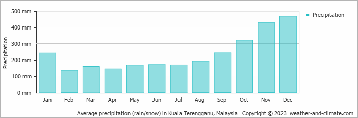
Location
Click on the blue arrow ![]() (top right) to see your current location on the map
(top right) to see your current location on the map