
Facts
- Elevation: 329 m (1,079 ft)
- Prominence: 329 m
- Peak category:
 Spesial
 - Province:
 Banten
 - Island: Panaitan
- Coordinates: -6.6027, 105.2426
- Rating:


 (3 votes) Add your rating
 Loading...
 - Other names: Also called Gunung Sri Mahapawitra in ancient times according to the Bujangga Manik Old Sundanese (Hindu) text.
Photos


Bagging It!
This peak is the highest point of the island of Panaitan off the remote south-western coast of Java in Ujung Kulon National Park. Gunung Raksa is not a Ribu, standing at a paltry 329m above sea level. It is included, however, because of the quality of the climb and jungle, archaeological interest, and the mountain’s unique location on Panaitan Island. On the summit there is an early statue of the Hindu god Ganesha and the lingam symbol of shiva. There is also an historic colonial survey marker. Panaitan Island has outstanding wildlife and jungle. Expect to see rusa deer, kancil (mouse deer), monkeys, python, and a wide variety of birdlife. Raksa is the highest point on Panaitan Island and is easily identified visually from the sea.
The starting point for the climb is Citambuyung, a small cove on the coastline southeast of the peak. There is a derelict shelter beside a small stream, which marks the beginning of the route. Route finding to the summit is aided somewhat by numbered red and white markers and by blazes carved into tree trunks. However, the mountain receives few ascents and the jungle grows back quickly over the trail – especially on the lower parts of the route, which follows the stream for approximately 1 kilometre. A golok (machete) is essential to cut rattan and other botanical obstacles. Parties should be confident in navigation and route-finding. If the path has been cleared recently, it should take around 2 hours to reach the summit. Encroachment by dense jungle slowed one recent party, who took over three hours to reach the top and ‘discover’ the statues.
This walk is in a pristine environment that rates as one of Java’s greatest ecological treasures. There is no litter on the trail – keep it that way!
For those wanting a good view of Gunung Raksa from elsewhere, the best spot might well be Karang Copong on Pulau Peucang. It takes about one hour to hike over from the pier on the other side of Pulau Peucang to what is a lovely promontory overlooking the ocean towards both Pulau Panaitan and the very tip of Java itself.
Bagging information provided by James Waite (updated by Dan Quinn, October 2017).
Nominated as a Spesial by James Waite.
Trail Map
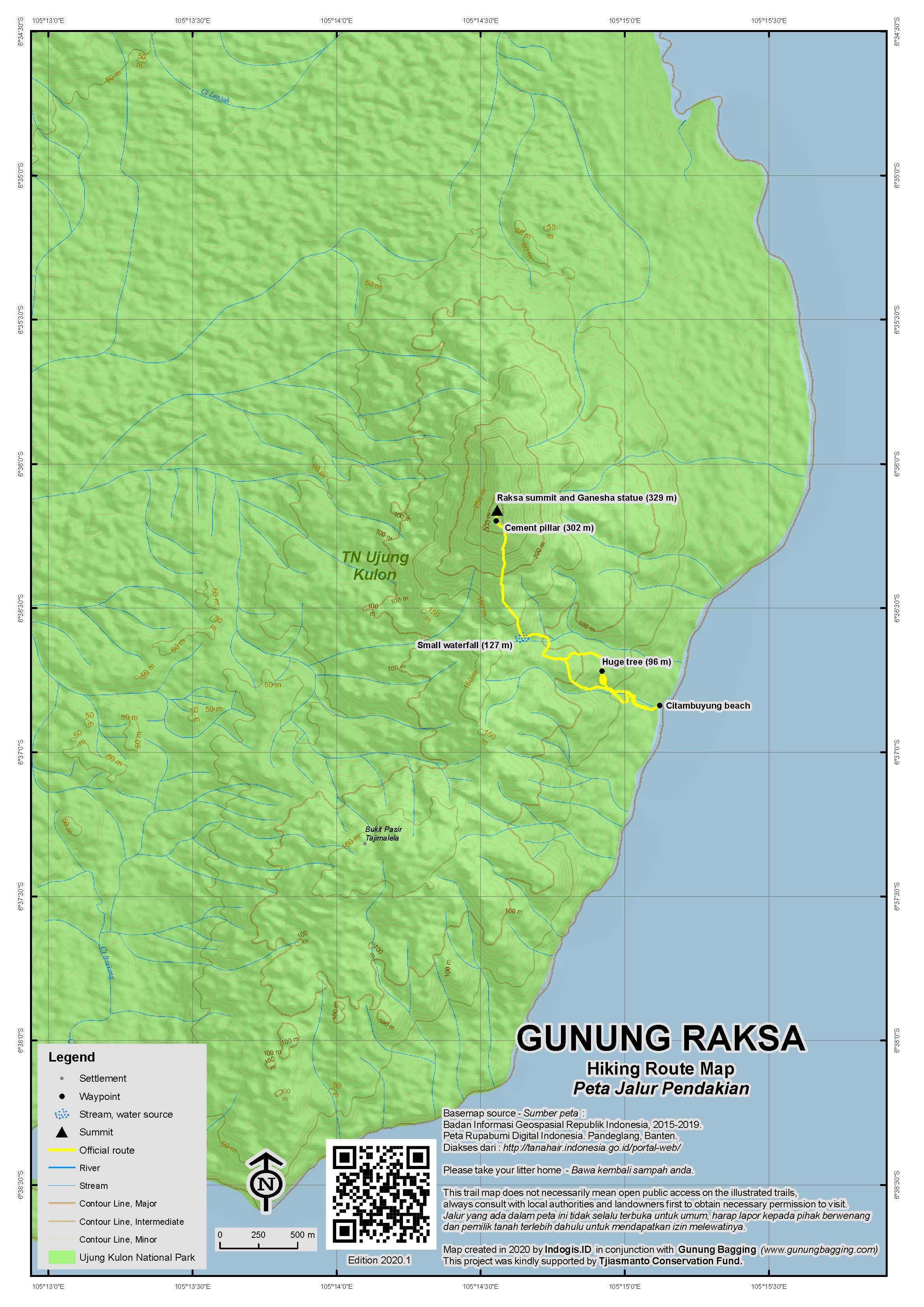
For a high quality PDF version of this and other trail maps, please download from our Trail Maps page.
Practicalities
- Getting there: For domestic flights from or to Banten, such as Jakarta’s Soekarno-Hatta International Airport, we recommend Baolau. To reach Panaitan Island, boats can be chartered out of Carita, Labuan, Tanjung Lesung or Sumur. A speedboat from Carita can reach Panaitan’s Legon Butun pier in under three hours. A traditional Indonesian fishing launch would take much longer.
- Guides and GPS Tracks: Want a PDF version for your phone? Looking for a guide? Need GPS tracks and waypoints? Gunung Raksa information pack can be downloaded here.
- Trip planning assistance: Would you like Gunung Bagging to personally help you in arranging your whole trip? Please contact us here.
- Permits: Your charter operator should arrange permits to enter the National Park and include it in the total price.
- Water sources: Take sufficient supplies with you – there are no shops on Panaitan. There are a few streams on the hike itself.
- Accommodation: Try the Booking.com map above or use this link to search for suitable hotels, homestays, resorts and apartments for your trip.
- We recommend Safety Wing as travel insurance for overseas travellers and tourists hiking up to elevations not exceeding 4500 metres.
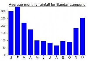
Local Average Monthly Rainfall (mm):
Location
Click on the blue arrow ![]() (top right) to see your current location on the map
(top right) to see your current location on the map
Origins and Meaning
Guardian Mountain. Raksa (also reksa) means “guardian” so Gunung Raksa may once have been seen as the sacred guardian of the surrounding area. (George Quinn, 2011)
The T.T. 223 (or T.T. 225?) is the Triangulatie Pilaar T. T. is an initial for Tertiar Triangulatie.
Many thanks to Paul S, author of ‘Searching for Ganesha’, for pointing out that the Ganesha statue at the top of Gn Raksa is not as old as was previously understood to be the case. He comments, “the Gunung Raksa statue seems to be a modified Majapahit form, very interesting”.
I hope it’s still there!
It sounds like Panaitan island was pretty badly hit during last year’s Anak Krakatau eruption, collapse and tsunami. Great BBC article link below…
https://www.bbc.com/news/science-environment-50798253
Went on a trip to Ujung Kulon at the weekend and although I didn’t visit Panaitan island itself, I got a few nice shots of Raksa from Pulau Peucang (as noted above). Karang Copong is an easy hour’s walk (less perhaps if you are not with a slow group) and the tree-fringed view over ocean reminded me a little of the view of Banda Api from Benteng Hollandia on Banda Besar, Maluku.
I’d still recommend staying at Panaitan itself either camping or on your boat (especially at weekends) as Peucang can get a bit crowded (and therefore noisy) and the facilities were so basic that I ended up sleeping on the boat instead anyway!
Apparently there are about 60 rhinos in the Park (on Java itself rather than Peucang or Panaitan) and some of them do go up onto the hill areas around Gunung Payung.
Top banter. My shorts are ruined.
Just back from a successful trip to climb Raksa – managed it in a regular weekend from Jakarta by driving down to Carita on Friday night, getting the speedboat over to Panaitan at 7am. After a pretty choppy start we finally reached Legon Butun by about 10.30am. The bay is beautiful and because the ranger’s offices are there it means that there is a generator providing light from 6pm until 10 or 11pm. Probably the best place to camp unless you have a large boat you can sleep on.
Because it was such nice weather, we decided to climb Raksa on the Saturday afternoon. The start of the hike at Citambuyung is approx. 20 minutes round the coast by speedboat. You may have to wade through shallow water to reach the land from the boat.
The trail is only clear if other people have climbed Raksa recently – the red and white markers show the way but it is very easy to lose them! The hike is not a straight-up hike – you have to ascend and descend slightly a few times before starting properly on the ascent. One of our group spotted what he thinks was a blue scorpion on the trail, so take care where you put your hands. There are also tons of spiny plants so gloves and long trousers are recommended.
The path is steep in places and this was tough on the descent when it was reduced to a slippery mudchute!
On the higher slopes, the path curves round the hill, and there are rocks either side of the trail which makes me think that in centuries past there may have been a purpose-built path for people visiting the statue.
Just before the true top you will find the presumably Dutch cement survey pillar (with “T.T 223” engraved on it). This is at about 300m above sea level and in less than 5 minutes you will have reached the Ganesha statue, sitting in a cement frame between two large boulders. Apparently there was another statue here until a few years ago when it was initially stolen and then rescued. According to our guide, it is now apparently kept in Bogor – in a museum presumably.
The boulder on the right of the statue is the true highest point of the mountain, so in order to bag it, Keith and myself just about managed to pull ourselves up the side of it, using the vines and the tree growing next to it for support.
There is not much of a view from the summit, but you get a sense of the considerable size and remoteness of Panaitan island itself. It took us just under 3 hours to reach the top and just over 2 hours to descend back to Citambuyung (mainly because of the slippery mud). A GPS device would definitely be useful here.
Back at Legon Butun we had a swim and watched the monitor lizards, monkeys and deer which wander around. We didn’t spot any crocodiles but there was a skull in the ranger’s office and they definitely live on the island – probably more likely to be spotted on the other side of the island.
On the return trip to Carita, it took just 2 and a half hours ad the weather was much better and the sea less choppy. Even so, the waves are pretty mad around Ujung Kulon so be prepared for a nauseating couple of hours!