
Facts
- Elevation: 1,346 m (4,416 ft)
- Prominence: 890 m
- Peak category:
 Spesial
 - Province:
 Banten
 - Coordinates: -6.3417, 105.9783
- Rating:


 (11 votes) Add your rating
 Loading...
Photos


Bagging It!
Until 2017, this peak was the most popular climb in Banten. It is less prominent and less high than nearby Gunung Karang but is more interesting. It is also a fairly easy hike – if you start early enough you can be back down in time for lunch and this is definitely a good idea as later in the day it would be unbearably hot. It is perfect as a last-minute day trip from Jakarta and takes just over two hours to get to in good traffic conditions.
However, there is one important issue to be aware of. Since 2017 or so, the original trail has been closed in Cilentung, and any hikers are encouraged not to use the trail. This is supposedly due to a landslide in the area making part of the trail impassable, but it seems likely there are other factors at play here, perhaps including the fact that there are possible dangers for local students camping at the crater and inhaling the gas. It certainly seems a strange decision to close the trail entirely, rather than simply modify rules and regulations, especially since some local people made money selling drinks and snacks on the trail in previous years and there is no legal reason why the trail should be closed.
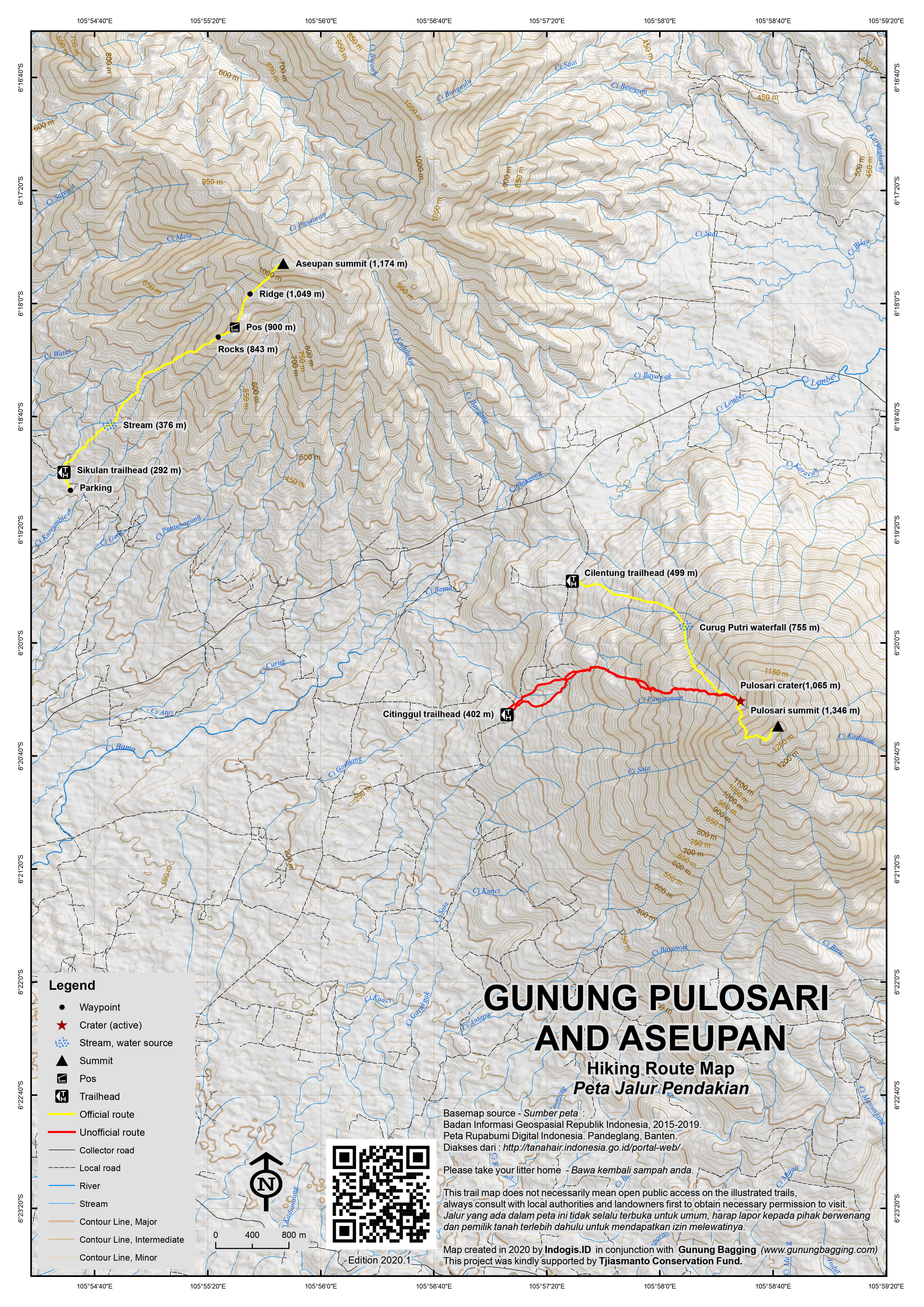
Thankfully, the crater and summit can still be accessed from a different direction, but this only applies to small groups with special permission and who take a local guide with them. Citinggul, a village to the west of the peak and along the same road beyond Cilentung, is the place to start. As the trail is not official it takes a little longer and there are various spots in which you could become lost without local knowledge. There are a couple of un-marked places on the road where you could begin your trek to the mountain, both a little over 400 metres in elevation.
Notable landmarks that you may pass or miss entirely on the way up include a water pool (465m), the edge of a field (625m), a hut (794m), a cement marker (856m), a fence into a small pepper plantation (943m and 963m as you enter and exit), and you are likely to meet the original Cilentung trail at around (1,021m) which in 2020 still had the remains of a collapsed and abandoned warung. From there, the pandan trees appear the most dominant plant species as you near the crater (1,065m) which yet again features sadly abandoned warungs.
For an account of the original trail, and of the way up to the summit from the crater, read our report from 2010 below. Note that although reaching the summit is still possible, the lack of visitors now means it is likely to be more overgrown and therefore require more time. To be on the safe side, allow 3 hours for Citinggul to the crater, 2 hours for a return trip from the crater to the summit, and 2 hours back down to Citinggul.
The trail starts north of the mountain in Cilentung, 20km beyond Pandeglang on the narrow road leading down to the west coast of Java at Labuan. On the main road, there is a large, modern sign (at 481m) for the Pulosari crater (kawah) and waterfall (curug) pointing the way down a very bumpy track. About one kilometer down this track is a warung (small shop) and the centre of the village of Cilentung. There are more signs for the crater and enough room for about 2 cars next to the warung (you may have to pay about Rp10,000 for parking).
You cannot miss the start of the trail (at 501m), which leads up beyond the village through plantation and there are many signs on the route itself. After less than an hour you should have reached the Curug Putri waterfall (at 750m) where you have to pay Rp4,500 per person at the hut. It is not the most impressive waterfall in Java by any means but certainly an interesting feature on the trail and a place to cool off. The path then leads steeply up to the right and after another 45 minutes you should be close to the impressive rocky crater area (at 1,065m). Beside the white rocks and often dense clouds of sulphur gases there is, once again, a small warung and this area is a very popular place for local students to camp at weekends.
Straight above the crater area is the summit itself, about 300m up at the top of the vegetated crater wall. You may be able to see the transmitter on top. The trail leads up to the right of the crater and there are some very steep drops to the west so take extra care here. Occasional stone markers and the inevitable litter mark the way. There are also monkeys in this area which you might see. After climbing steeply over tree roots the vegetation becomes less dense and you see over the valley to the lesser peak of Aseupan and Java’s west coastline. As you near the top, there is a great spot looking directly west to Labuan and the Sunda Straits from the south-western edge of the narrow summit plateau. In good visibility the Krakatau islands lie directly beyond the power station chimney at Labuan.
Another ten minutes on the trail and you should have reached the peak. The fairly low height of the vegetation means that there are good views in all directions. The summit is crowned with a transmitter and earthquake monitoring equipment. There are a few places where local students like to camp at weekends. At the north-eastern tip of the summit ridge, beyond the transmitter, is a good vantage point for Gunung Karang and an occasional source of water. After enjoying the great views head back down the same way. Fast walkers can be back in Cilentung in two hours. Not bad for a day hike out of Jakarta!
Gunung Aseupan (1,174m)
Gunung Aseupan is the third highest peak in this region and is also a worthwhile day out. It is a complex range with various peaks. The two highest peaks can be hiked from separate starting points. The ridge which is the eastern part of the range can be accessed from the south via Ulun Jaya at Pak Marsem’s warung (455m) or nearby Pandat. The highest point of this long ridge is around 1,098m (but 1,127m according to the Bakosurtanal map) but has no views. (Thanks to John Hargreaves for this information).
However, the true summit is further west and is accessed from the south-west at Desa Sikulan (280m). This peak is clearly seen as a shapely triangle from the villages and main road below and is 1,174m above sea level. The shape of the peak gives the mountain its name. The true summit can be reached via two different ridges, but the more direct one leads to an incredibly overgrown and dangerously steep section just below the summit. Best take the slightly more eastern one that is clear for the most part. A guide will probably be needed as there are numerous junctions on the lower slopes of the mountain. Ask in the village for Bang Handa.
Lower down, the mountain is covered in clove and durian trees and there are also some attractive rice paddies. Higher up, the trail leads along a narrow, slippery forest ridge. There are lots of thorny plants here and also a few leeches. Near the summit are some pitcher plants (the Javan Nepenthes gymnamphora, according to expert Alastair Robinson). The summit itself is a small grassy area with excellent views in clear conditions of lower peaks in the range plus the other Pandeglang mountains and the coastline near Labuan. There is also an ancient grave and a summit sign. Most fit hikers can reach the top in 4-5 hours and be back down in 3-4, meaning this is possible as a daytrip from Jakarta if you set off before light.
Whereas in previous years nearby Pulosari saw many, many visitors every weekend, Gunung Aseupan is still not famous and only sees a handful of hikers each year (in 2020) though this may change in the future.
Bagging information by Daniel Quinn (last updated in June 2020)
Trail Map
For a high quality PDF version of this and other trail maps, please download from our Trail Maps page.
Practicalities
- Getting there: For domestic flights from or to Banten, such as Jakarta’s Soekarno-Hatta International Airport, we recommend Baolau. From Jakarta, take the toll road towards Merak, exit at the Pandeglang turn-off and turn right several kilometres beyond the town. For public transport, there are plenty of buses calling at Serang from where you can take an angkot to Pandeglang and then an ojek or further angkot onward to the starting point.
- Guides and GPS Tracks: Want a PDF version for your phone? Looking for a guide? Need GPS tracks and waypoints? Gunung Pulosari information pack can be downloaded here.
- Trip planning assistance: Would you like Gunung Bagging to personally help you in arranging your whole trip? Please contact us here.
- Guides and GPS Tracks: Looking for a guide? Need GPS tracks and waypoints? Join Gunung Bagging Premium here.
- Permits: Ticket required and trail currently closed in 2019.
- Water sources: Originally available all the way to the crater on the Cilentung route but probably too much sulphur in it to be safe. For the Citinggul approach take enough sources with you.
- Accommodation: Try the Booking.com map above or use this link to search for suitable hotels, homestays, resorts and apartments for your trip.
- We recommend Safety Wing as travel insurance for overseas travellers and tourists hiking up to elevations not exceeding 4500 metres.
Local Average Monthly Rainfall (mm):
Location
Click on the blue arrow ![]() (top right) to see your current location on the map
(top right) to see your current location on the map
Origins and Meaning
(unclear) Pulo usually means “an island” but it also appears in several place names in Java (e.g. around Krawang) that are quite far from the sea. So it is possible that pulo also means something like “an outcrop”, “a prominence”, “something that rises from flat surroundings whether from the sea or from the land” or “an enclosed place”. It is also possible that pulo is a corruption of pala or pahala (pronounced /polo/ in Javanese) = “divinely bestowed reward for good deeds” or “the fruit of one’s deeds”, or simply “fruit”. Pulosari, then, might mean “the essence of divine reward” i.e. harking back to a time when people believed in karmic reward for good deeds, and mountains were venerated as the abode of deities and the source of good things. (George Quinn, 2011)
Had a great trip out yesterday to the Banten mountains. First hikes in over 3 months, which along with doing 2 in a day, may explain why I was quite a bit slower than usual.
The plan was both Pulosari and Karang, with Karang the main target due to it being higher and more prominent (and a Ribu). Pulosari is perhaps more photogenic though, so we opted for that one first.
As reports above will explain, access is now more difficult, Back in 2010, it was a popular tourist site, with locals selling snacks at warungs all the way up to the crater. After a landslide in December 2017 near the waterfall, all is changed and folk are forbidden from using the old trail and the warungs have been abandoned.
Anyway, with special permission, you can still get to the crater and peak but you need to choose a different access point, namely Citinggul. The trail up to the crater is not a trail, but just overgrown bush, so a local guide is obligatory. Because of this it took us a while longer to reach the crater than expected, so we didn’t continue to the summit as we still had Karang to do the same day and two of us had bagged the summit many years previously anyway!
Our guides from Citinggul were great, and carried ‘hunting horns’ to communicate with each other using specific sounds! Let’s hope this can become a proper trail in the future…..
Not recommended. The site is dirty, crowded, poorly maintained. It is not well organized. Many unofficial people is trying to ask for money if they knew somebody will make a trip to the summit.
This comment not fits to the location… there is no “site” and the track is (April 2019) abandoned.
Gunung Pulosari trail is closed! I went in September 2018 there from Jakarta.
– Don’t take the narrow direct road as there are heavy construction’s for years.
Go to Palemglang and take a new road from there.
– the trail is officially closed since the beginning of 2018. the reasons hadn’t been clear, locals talked about a serious damage of the trail, a landslide and falling rocks and 2 missing hikers.
– the Hut at the start of the trail was closed, there was a big banner that the trail is closed.
Well, we entered a few meters aside so we did not get the information and started hikung. the path is still visible but starts to get overgrown by bushes. There are NO signs left, everything aside 3 little concrete poles have been removed. 2 x it is quite tricky to find the right way up.
the Hut at the waterfall was clean but abandoned.
we met a friendly farmer who showed us the path and told us just 45 min more.
we walked up without any serious problems, it was a nice hike, but ONLY for experienced hikers who know how to walk and orientate themselves without signs.
we cam back after about 3 hours… and then saw the banner about being closed.
our driver told us there was a local officer who wanted to talk to us. But as we arrived back he was sleeping so we just paid 10.000 for parking and left.
Enjoyed a great day trip out today to Gunung Aseupan, a mountain I have had my eye on for quite a while. Information online is vague, but thanks to John Hargeaves we were able to find the starting point for the true summit. We set off from Jakarta at just after 4am and were searching for a local guide in Desa Sikulan before 7am.
After the usual comments that we would need a full day just to reach the top, we managed to find Bang Suhanda (081574742236), a very tough and experienced local young man who was very much up for the adventure. Amusingly, his mother asked if I had brought a gun, to which I said no and asked why. She replied that she wanted a pistol because there was a squirrel disturbing her coconut palms!!!
For some reaosn we set off through rice paddies and straight up the nearest ridge which was great about as high as 750m (where there is a tree stump with a human face drawn onto it), but then became very overgrown and thorny. Things got a little easier higher up and we were making good progress despite the many spiny plants, slippery mud and occasional leech. But suddenly we reached thick vegetation just 120m or so below the peak. Incredibly steep terrain and not much to hold on to except spines and rotten wood. Very difficult and dangerous. But we were so close so we bashed our way through it, managed to get up to the top alive, but a bit bruised and cut! At the summit, we found the clear path which leads up from slightly further east and this is obviously the path to use as the way we came up cannot be recommended even to your worst enemies!
It was a little hazy at the top, but still nice, with swallows swooping around the airy summit. The more eastern, second-highest peak in the range was clearly visible, but the coast and other ranges were lost in cloud and/or haze. There is enough space at the top for a small tent or two. The grave is presumably that of an important local figures from centuries ago. GPS reading was around 1177 to 1180 so 1174m sounds accurate enough as an official height. Bang Handa told us of a nocturnal rabbit-like creature of gold colour that lives on the mountain, but not being night-time we didn’t see it!
It took us 3hr 40min to the top via the crazy route, and about 3 hours back down the sane route so, as we had a car, we were back in Jakarta before dusk. The very kind family of Bang Suhanda raced after the car on a motorbike, chasing us for a good 15 minutes or more in order to give us some kelapa muda to take back to Jakarta with us. Really kind, and something we will remember for a long time. Thank you! Now I just need to find a machete (and maybe a pistol too)!
You can also climb Gunung Aseupan (altitude 1098m), the “third mountain” in this area, lying west from Gunung Karang and northwest from Gunung Pulosari.
We climbed Aseupan from a village called Ulun Jaya. Coming from Pandeglang, you continue a kilometer or so along the main road beyond the turn off (left) to Pulosari, until you can turn off right up to Ulun Jaya. Park beside Pak Marsem’s warung at the top of the village (altitude 455m). From the warung it takes five minutes to get onto a broad path heading up a ridge on the mountain’s northeast flank. You will reach a crossroads after about an hour. From the crossroads you take the worst-defined path heading straight on and bash through some undergrowth for 15 minutes or so until you join up with a well-trodden main ridge path that heads up through clove trees. The ridge narrows sharply and the clove trees are replaced by forest but the path remains clear and it is impossible to stray off the ridge. At the summit there’s a small clearing and a sign on a tree, but no view.
Rather than bushwhacking across through the thickets to get back to the secondary ridge, we descended directly along the same primary ridge path, which becomes a well-used plantation trail below 800m. It emerged in grassy meadows above the village of Pandat, which lies directly on the main road. We cut across fields from here to get back to Ulun Jaya, but if you could get clear directions from Pandat over the lower slopes, you would be able to follow a comfortable trail all the way up to the summit.
Well, it’s good information for me and my team cause this Sunday I’ll go there.
Go Green the Nature.
A very enjoyable and nicely spaced out hike, being about an hour to the waterfall, another hour to the crater and a further hour to the summit. It would be good for families because you can turn back at the waterfall or the crater and still consider it a success!
One navigation point we found tricky. The trail from the crater up to the summit exits from the northwest corner of the crater area (lower right as you come up). So the trail hardly passes through the crater area at all. You just arrive at the lower lip, go right for twenty meters and reenter the forest to resume ascending beyond the right edge of the crater rim.