
Facts
- Elevation: 1,894 m (6,214 ft)
- Prominence: 617 m
- Peak category:
 Spesial
 - Province:
 Jawa Tengah (Central Java)
 - Coordinates: -7.3610, 110.3999
- Rating:

 (5 votes) Add your rating
 Loading...
Photos


Bagging It!
This small mountain lies near Salatiga, to the north of the huge Merbabu mountain. It is very easy to ‘climb’ because there is a road to the communications towers at the summit. Apparently it is very popular with paragliders. Entry is via Dalangan village, which lies to the south of the mountain, and you can actually drive all the way to the very top. In clear weather the views of the higher mountains of Central Java are fabulous, although the summit itself is a jungle of radio masts and antennae!
From Dalangan village (approximately 1,290m), there is a rusty Telomoyo sign which points the way to metal gates at the base of the mountain. It costs a very reasonable Rp5,000 for entry (per vehicle – in 2010!) and the gates are open from 8am until 5pm daily. The road is very bumpy in places but a regular car should be able to manage it. The only problem would be if you meet another car coming in the opposite direction as there aren’t many places to pull over to one side! You could always get an ojek (motorcycle taxi) from the village – lots of teenagers ride up the mountain at weekends. Alternatively you could even walk up the road – although it is several kilometres long it is very pleasant and there is even a mini waterfall. It would take less than 2 hours on foot, perhaps 3 hours to climb and descend again.
The view from the road itself is spectacular – Merbabu, Gunung Andong (the small pyramid mountain across the valley), Sumbing and Sindoro. Indeed, the view is better from the road than from the actual summit itself which is covered in transmitters. At the top, you may need to ask one of the workers in the mast compound to open the gates so you can turn your vehicle around more easily. It takes about 30 minutes each way by motorbike or car from the entrance gates.
The smaller Gunung Andong (1,731m) is also a worthwhile outing, especially at dawn and dusk. From the impressive entrance built from empty water bottles at Dusun Sawit (1,320m) it only takes an hour for reasonably fit hikers to reach the summit ridge. Views of Merbabu, Merapi, Telomoyo, Ungaran, Sumbing and Sindoro are fantastic.
Once through the bottle entrance you soon reach a T-junction where you take a right. Very soon after, you take a left and from this point on the trail is very obvious and clear, though a little slippery and muddy in wet weather. Some minor bamboo shelters (Pos) are soon reached (Pos 1 Watu Pocong ‘ghost rock’ – 1,398m, Pos 2 Watu Gambir ‘resin rock’ – 1,466m, and Pos 3 Watu Wayang ‘puppet rock’ – 1,630m) as the trail steepens and you suddenly find yourself reaching the rather narrow and airy ridge with steep drops on either side.
Straight ahead is a building or mini-pavilion known as Puncak Makam (‘tomb peak’ – 1,705m) which houses the grave of Joko Pekik, a respected local man. The backdrop is Sumbing, Sindoro and the flattish ridge of Gunung Prau (Dieng). The main path continues up to the right and the true summit of Gunung Andong (Puncak Jiwa) which has a flagpole and signs. This is a brilliant viewpoint and, given that it only takes an hour to get to, most weekends the entire ridge is covered in tents to the extent that there is no more space for any more! There is also a warung selling snacks!
For a bit more peace and quiet, either hike here during the week or continue along the narrow ridge (Jembatan Setan – ‘Devil’s bridge’) in the general direction of Telomoyo. A slightly lower peak (Puncak Alap Alap – 1,715m) on the Andong ridge, this final top is another great vantage point for looking back to the highest Andong peak which from this angle looks very precipitous and like a steep pyramid, plus Merbabu and Merapi to the right (south) and Ungaran to the left. There is also another warung here!
Strong hikers can be back down at the village in 45 minutes or less, but this is definitely a place to linger if you’re lucky enough to not be surrounded by 200 tents!
Bagging information by Daniel Quinn (updated to include Andong information in January 2018).
Trail Map
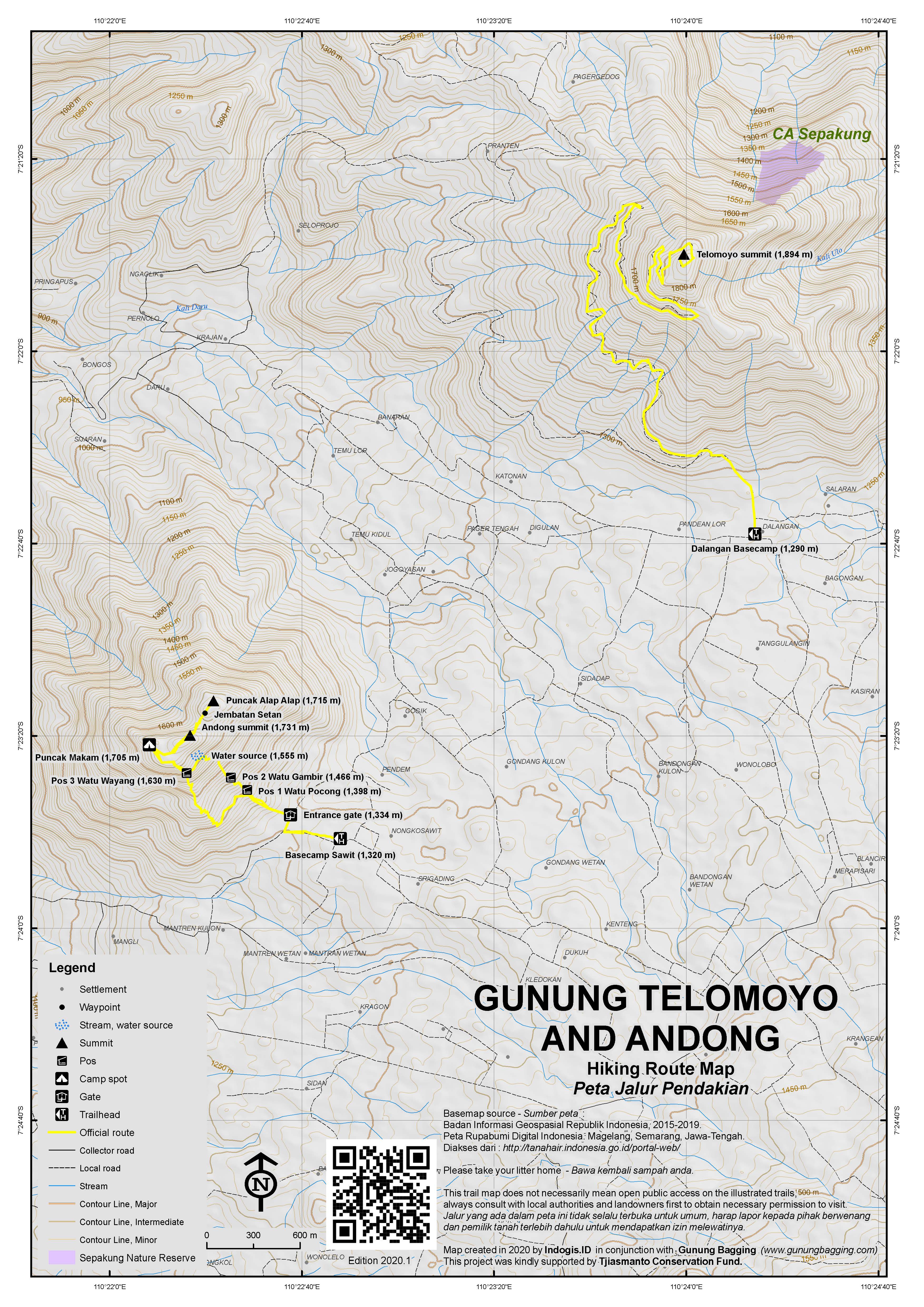
For a high quality PDF version of this and other trail maps, please download from our Trail Maps page.
Practicalities
- Getting there: For domestic flights from or to Central Java, such as the airports in Semarang, Solo (Surakarta) and Yogyakarta/Jogjakarta we recommend Baolau. The nearest airport is Semarang. There are lots of transport options – taxi, bus/angkot or ojek (motorcycle taxi). From the Salatiga – Magelang road near Kopeng take the small but signposted turning to Dalangan (2km) and take a left at the T-junction. Shortly after the T-junction take a right to the entrance gate.
- Guides and GPS Tracks: Want a PDF version for your phone? Looking for a guide? Need GPS tracks and waypoints? Gunung Telomoyo information pack can be downloaded here.
- Trip planning assistance: Would you like Gunung Bagging to personally help you in arranging your whole trip? Please contact us here.
- Permits: For Telomoyo, you have to buy an entrance ticket in Dalangan village, just Rp 5,000 (back in 2010), payable at the entrance gates. For Gunung Andong, the price is Rp8,000 per hiker (in 2018) from the entrance booth in Dusun Sawit which is just ten nimutes by motorbike from Kopeng.
- Water sources: If you are driving up you obviously won’t need any! If you fancy walking up the road instead, taken sufficient supplies with you. For Gunung Andong, there is a water pipe halfway up, but there are also a couple of warungs selling snacks and drinks on the summit ridge!
- Accommodation: Try the Booking.com map above or use this link to search for suitable hotels, homestays, resorts and apartments for your trip.
- We recommend Safety Wing as travel insurance for overseas travellers and tourists hiking up to elevations not exceeding 4500 metres.
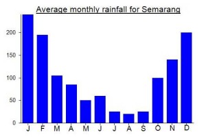
Local Average Monthly Rainfall (mm):
Location
Click on the blue arrow ![]() (top right) to see your current location on the map
(top right) to see your current location on the map
Origins and Meaning
(unclear). Telomoyo is probably from the Javanese tela (pronounced /TAY.lo/) meaning “clearly visible” and maya (pronounced /MO.yo/) meaning “lightly coloured and hazy”. (George Quinn, 2011)
I have not climbed Telomoyo yet, but I did go up Andong on a Sunday morning on the last day in June.
We stayed in Salatiga in the Laras Asri Resort, a highly recommendable hotel with a traditional Javanese ambience. From there, we set out by car at 03.00, following the WazeApp directions to ‘Gunung Andong via Pendem’. The route follows the main Kopeng road before shifting onto single track country lanes, bumping over potholes through ghostly farming villages lit by scattered LED lamps. Approaching our destination at 04.00, we seemed so far off the beaten track that we began to wonder whether the ‘basecamp’ would afford enough space to turn our car around.
In fact, the basecamp turned out to be something like a busy train station, with hundreds of motorbikes thronging the parking lot, dark figures milling around in warm hiking gear, a toilet and a large car park located separately another 100m up the hill. A man in a ticket booth sold us three tickets – Rp21,000 per person plus Rp20,000 for the car – and we set off up the concrete farm path leading to the forest entry, marked by giant letters spelling ‘G. Andong’.
This is indeed a good place for beginner hikers, as the trail is broad, not too steep and abundantly signed. After five minutes the path splits into a ‘jalur utara’ (north trail) leading to Puncak Alap Alap, and a ‘jalur selatan’ (south trail), leading to Puncak Makam. We went up via the north, walked along the summit ridge, and came down via the south.
Once above the forest, the views of Merapi, Merbabu and Telomoyo, with its brightly lit radio masts, are terrific. We reached Puncak Alap-alap at 05.30, shortly after dawn. Our GPS showed an altitude of 1734m for Puncak Alap-alap, which is at the north end of the ridge, and 1751m for Puncak Andong, differing significantly from the ‘official’ heights.
As reported in other posts here, the summit ridge was swarming with hundreds of tents, and perhaps thousands of hikers, making this the busiest summit area I can remember anywhere. Many people were cooking an early morning meal, although the warung is still there with its hot food and drinks. With little wind and a large crowd, the temperature was not cold at the top. The sunrise turned out disappointing as the sun struggled to pierce the morning mist on the horizon. Sumbing and Sindoro to the west were visible but not distinct enough for good photos.
After starting back down at 06.30, we reached the car park by 07.30, with plenty of time to drive down to Salatiga by 08.30 to enjoy the hotel breakfast.
Managed the Telomoyo-Andong double over the last 2 days. I flew from Australia to Bali and the plane was delayed so only managed to get 2 hours sleep before my flight to Kulon Progo. The new airport in Yogyakarta is around 1 hour and 15 minutes from the city whereas the old airport was right in town so the travel is now quite considerable. I arranged an Nmax from Mytripyogya and it was delivered to my hotel 10 minutes earlier than agreed, which is incredible in its own right. I rode out to Telomoyo, around 2 hours from Yogyakarta via the Ketep Pass. The views along this stretch are amazing and truly worth the time.
At the base of Telomoyo they charge 15,000 rupiah for entry. Three times what Dan has said that it cost in 2010. There was a sign saying the road is now open 24 hours which I didn’t confirm but this seems to be true. I think they do lock the top section though so if you wanted to go to the very top you’d have to go during the day.
There are so many masts up there it isn’t funny. The old decrepit ones still stand and it seems they just leave them when they add a new one. I was planning to climb Andong straight after but on the way down I picked up a nail in the back tyre and had to get that fixed and by that point it was too late.
The next day I was in Bandungan and made the 1 hour drive to Andong. I went via the Pendem trail. They charged 20k for entry and 5k to park the bike. I got a run down of the route from the man at the entry and he explained all the routes. There are signs all over the place so its impossible to get lost. I made the loop up the Pendem trail, down the Sawit and then there is a trail that links the 2 back together near the bottom.
I was at the summit ridge in 33 minutes and at the true summit after 40 minutes. It was complete and utter whiteout. Couldn’t see more than 50m in front so I stayed on the summit for 5 minutes chatting with some Indonesians from Yogyakarta. It was pointless to hang around as there was nothing to see so I ran back down and was at the base after 63 minutes.
As with all things gunung-related in Java in the past few years, things have exploded at Telomoyo and Andong, with lots of other villages wanting a slice of the action (entrance fees) by setting up different routes up them.
In addition to the original ad still most popular Sawit trailhead, Andong now has Pendem basecamp just 500m away from Sawit, and Gogik to the east of the mountain (presumably you could hike up from Sawit and drop down after Alap Alap via Pos 4 Watu Kotak down to Gogik, unless of course there are any inane rules prevent traverses as is the case on many bigger mountains). There’s also a nameless basecamp listed to the north of the mountain but no name or other info.
As for Telomoyo, two new routes up from the south start at Arsal and Watu Tuumpeng. They are very close to the main road entrance at Dalangan, but avoid using the road itself, which is surely a good thing at weekends. There’s also a trekking route up from the northwest at Pagergedog, but this looks mostly on roads too.
Telomoyo has been the centre of an earthquake swarm this week. Will be interesting to see what happens next, if anything…
Hiked up Gn Andong, near Telomoyo, yesterday morning. Fabulous views, apart from the 200 tents that you find up there at the weekend. An easy stroll really – 1 hour up and maximum 1 hour back down again, and just 15 minutes by ojek from Kopeng where there are numerous basic losmen (for Rp100,000 a night or even less) that seem mostly empty even during weekends.
Near the ticket booth is a fantastic entrance constructed from hundreds of empty aqua bottles – a truly commendable use of ‘litter’.
Anyway, if Telomoyo is too easy for you (you can drive up), then Andong is greatly recommended for beginner hikers. You don’t often get such an amazing panorama for so little effort. I set off hiking at around 3.30am and was up on the ridge by 4.30am ish, going slowly. A little cloudy (it is January after all) but still a great view in all directions. A bit too much noise from local campers (I had to ask one boy to turn his incredibly loud ghettoblaster down) but, alas, that is Java these days.
I actually got a Grab ojek all the way from Semarang Tawang station to Kopeng. Just Rp108,000 (and took nearly 2 hours due to a fair bit of traiffic near Semarang). Gave him Rp150,000 though, as he would obviously struggle to find more customers heading in the opposite direction.
Kopeng and the Ketep Pass over to Magelang is a fabulous spot with enormous potential. The temperature is perfect, the views stunning, and you can grow all sorts of nice vegetables up here that are impossible to cultivate at sea level. Beer is readily available and there’s even a 24-hour Alfamart. More serious hikers will know this area as the Cuntel route up Merbabu starts/ends here.