Facts
- Elevation: 705 m (2,313 ft)
- Prominence: 705 m
- Ribu category:Spesial
- Province: Bangka Belitung
- Google Earth: kml
- Rating:

 (2 votes) Add your rating
 Loading...
 - Other names: Bui sometimes spelt with a ‘k’ = Buik or ‘h’ = Buih
Photos


Bagging It!
Gunung Maras is the name given to the largest mountain range on the island of Bangka. Whilst not especially high by Indonesian standards, it consists of two fairly separate peaks with a not inconsiderable drop between them known as Tambun Tulang. The range is one of the best places on the island to spot wildlife and the higher slopes offer some decent panoramas of the land below and coastline in the distance.
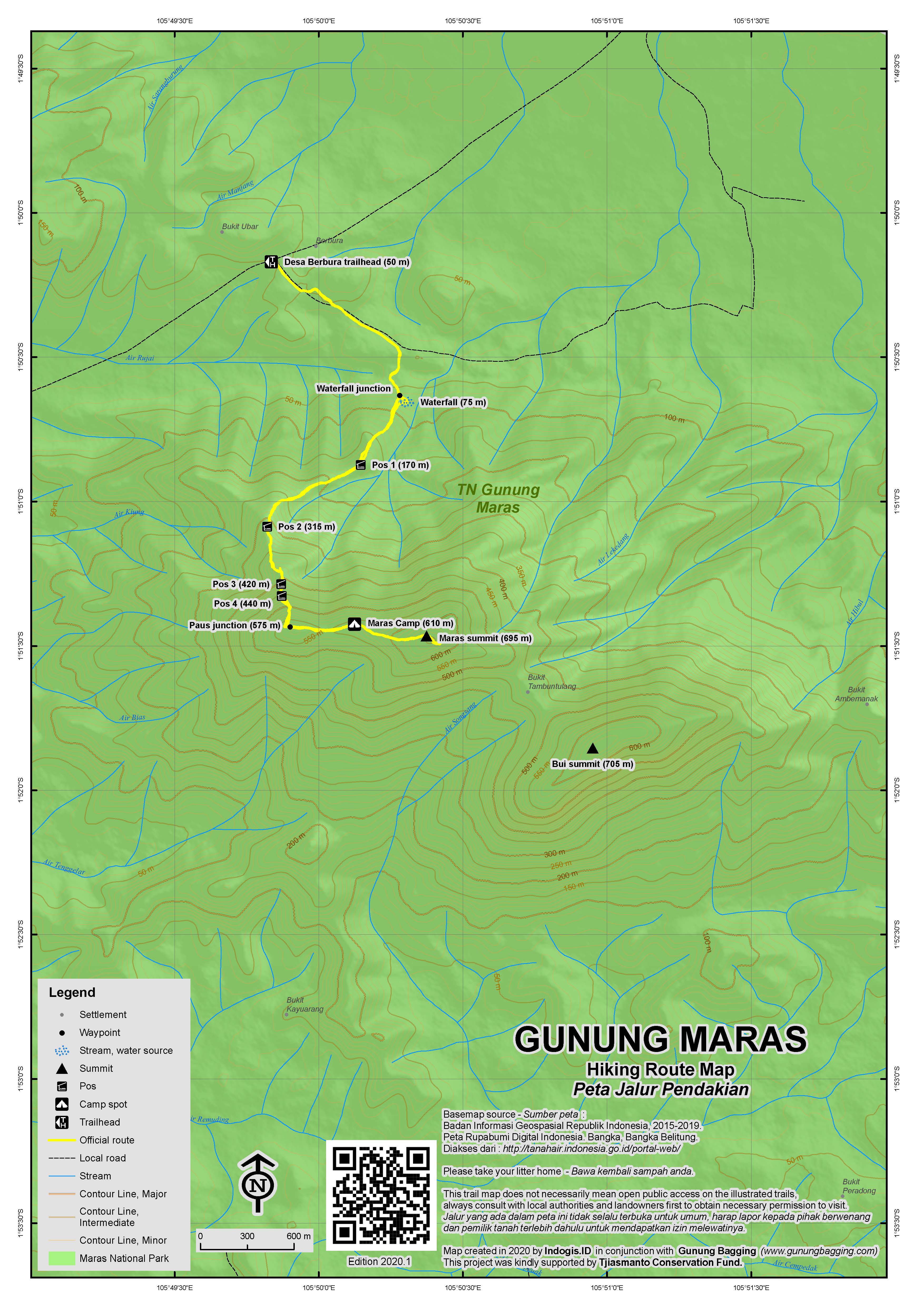
The northwestern of the two peaks is the most commonly-hiked, and there is even a sign for Gunung Maras at the village of Berbura which lies to the north of the range (about 1hr 30min from the main town of Pangkal Pinang by car or motorbike). This peak is generally known as Gunung Maras, although at 695m – or possibly less – it is actually the second-highest. The true summit is the southeastern one, which is rarely climbed and known as Bui (also spelt Buih and Buik).
The regular trail up the northwestern peak starts at Desa Berbura at an elevation of just 50m. It is important to start as early as possible and to take plenty of water with you. The earth here is sandy, and as the trail leads through rubber plantations you will find yourself walking on the sort of earth you might normally expect on a beach known as ‘pasir putih’ to Indonesians. You will see the mountain straight ahead with a number of minor tops.
After a short while you will have reached a small junction near a river (75m). Straight on is a litter-strewn bathing area (AKA Berbura waterfall) and right leads up the mountain itself. The trail passes Pos 1 (170m), Pos 2 (315m) after which you reach patchy woodland offering some decent views to the valley below and Teluk Kelabat beyond to the north and northwest. You may be able to pick out the small island possibly still known as Pulau Kajuanak.
After an hour you will be in an area which offers a great view of Gunung Maras above with two Pos very close to each other (Pos 3 at 420m and Pos 4 at 440m). Sadly, this great view was made possible by a forest fire in 2015. From an elevation of around 500m or so you may be able to spot pitcher plants – Nepenthes Reinwardtiana – growing near the path.
The trail changes direction from southwards tto eastwards at a point which may or may not be known as Simpang Paus / Paus junction (575m). The trail from this point steepens and begins to feel more mountain-like as you gain the ridge. There are also at least two rocks with very interesting patterns or writing on them which at first appear to be ancient Sanskrit carvings. According to experts Made (@harimbawa) and Arlo Griffiths, however, these are fairly recent inscriptions probably using Roman alphabet but stylized in a Sanskrit fashion to list a team of hikers (IW, Damai, Yanuar, Yayan, Dwi).
The first ‘summit’ you reach is a large wooded area (610m) where local students often camp at the weekends and enjoy the views. It should have taken you no more than 2 or 3 hours to reach this point. However, another 15-20 minutes will take you to a higher grassy peak. This grassy peak is around 695m in elevation and in clear weather the views are very nice but perhaps not as good as near the wooded camping area.
Alas, the highest point of the range, known as Bui, is 1.3km to the southeast and via a steep drop down to a col known as Tambun Tulang, a place that people have become lost in before and in which navigating might be very difficult in cloudy conditions. Bui appears to be 705m, according to archival US Army Mapping Service (AMS) maps from the 1940s. The same figure of 705m on modern provincial maps of Bangka Belitung is given as the highest point, which conflicts with the more commonly found figure of 699m for Maras itself. The accessible grassy peak known as Maras to most local hikers probably is around 695m or perhaps a little under, but at over 700m Bui is the true peak. The 1940s maps suggest that there is a trig point at the summit of Bui, so this deserves further investigation too.
To get back down to the trailhead from Maras peak is about 2 hours. For those wishing to try to reach Bui from this side, be warned that locals regard this peak as mystical and potentially dangerous and hikers have become lost in the col before. There is no clear trail down to Tambun Tulang except as far as a water source which often only offers a tiny amount of water. Without enough time and sufficient spare water it is not recommended to try Bui from this side. If you have plenty of water and a day to try to reach Bui and get back to camp (and also the permission from the villagers at Berbura) then you might be able to make it although the terrain is by no means easy.
A second route to the range starts in Dalil (only 45 minutes from Pangkal Pinang) and is entirely separate from the Berbura trail to Maras ridge. It is closer to Bui whereas Berbura is closer to Maras. The mountain is 9km from the main road at Dalil but motorbikes should be able to get you much closer. The Dalil side also has a waterfall and a minor rocky top known as Idat Peak or Puncak Idat. This ‘peak’ is only around 200m above sea level and does not have views as good as from the Maras ridge, but it may be a decent ‘basecamp’ for an attempt on Bui summit from this side, not requiring the big drop down via Tambun Tulang. However it still remains unclear if there is anything resembling even a faint trail to the top from this side and attempts to get in touch with locals who have been up here have not been very successful so far.
Bagging information by Dan Quinn (May 2017, updated July 2018)
Trail Map
For a high quality PDF version of this and other trail maps, please download from our Trail Maps page.
Local Accommodation
Practicalities
- Getting there: Numerous flights from Jakarta to Pangkal Pinang every day. It takes about 45 minutes to Dalil or 1hr 30min by car or motorbike to Berbura from Pangkal Pinang.
- Guides and GPS Tracks: Want a PDF version for your phone? Looking for a guide? Need GPS tracks and waypoints? Gunung Maras information pack can be downloaded here.
- Permits: Register at Berbura or Dalil.
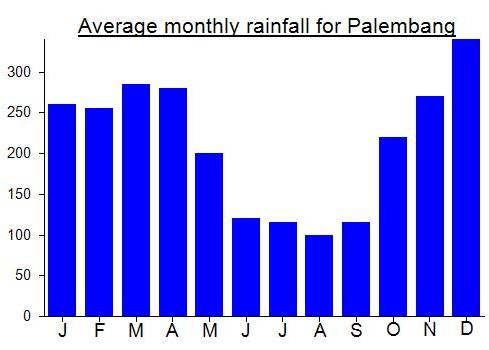
- Water sources: The waterfall areas at the foot of the mountain on both the Berbura and Dalil sides (100m above sea level only).
Local Average Monthly Rainfall (mm):
Latest update from a new local guide who often hikes the range – Air Layang is likely the best starting point for an attempt on Bui / Buik – the highest peak of the island and indeed the province.
Most hikes people undertake, wherever in the world, leave them feeling better afterwards, maybe even enlightened in some way. My second trip to Maras/Bui was not one of those! It was one of those trips, not uncommon in Indonesia, that feel like a migraine from start to finish. It really needn’t be this way, and maybe in another decade it won’t be, but for now all I can do is try to find it funny.
Quite how the first flight of the the day for an aircraft can be over an hour late on arrival after a 50 minute flight in perfect weather conditions is a mystery in most parts of the world. Alas, in Indonesia, from Jakarta’s Soekarno Hatta Airport, with Lion Air, it is completely normal. You would think these occurrences would encourage management and ground staff to work out how they can improve matters but it seems they simply can’t be bothered to improve things. We were standing around waiting for an airport bus to take us to the aircraft for about 20 minutes. The bus ride itself took another 20 minutes. And then we sat on the plane for another 20 minutes or more just waiting to join the queue of planes trying to leave the horrific haze of Jakarta’s skies and hopefully land somewhere where walking down the road would not be as bad as smoking a whole packet of cigarettes.
Arrived in Bangka over an hour late, as mentioned above. Met my guide and his friends and headed off to Berbura, 90 minutes by motorbike and via the interestingly named Puding Besar (‘big pudding’).
Having already hiked Gunung Maras and seen the considerable drop (200m or so) down to the col connecting Maras with the slightly higher Gunung Bui / Buik I had tried to find someone in advance at the alternative starting point of Dalil, much closer to the main town of Pangkal Pinang and the airport. I found a ‘Dalil Guide’ but not only did he find it hard to communicate in Bahasa Indonesia (rather than the local language which is incomprehensible to anyone outside this region), he also had very little knowledge of Gunung Bui, the highest peak of his island, and indeed the province of Bangka Belitung, which was just a few km behind his village and pretty much the only natural landmark in this part of the island. You would think this peak would be a source of local pride, and there would be sufficient initiative and curiosity to make a hike to the top of the island (and province) a worthy outing and something worth promoting as a great reason to visit Bangka.
This Dalil guide said he knew someone who might be able to try to take me up the mountain, but it was rarely visited. I asked if it would be possible to get an ojek (motorbike taxi) to pick me up at the airport and take me back again the following day, at a rate similar to a normal regular car taxi. No ojeks in Dalil, came the response, despite it being very good money and people in the area being pretty poor. Why anyone wouldn’t want the cash for a 40min ride is difficult to ascertain. Anyway…. I then asked if I could have the number of the person who might be able to help on a trip up to Gunung Bui and Mr Dalil guide responded that his friend did not have a phone. In Indonesia…. hard to believe. It was as if they didn’t want to even try hiking this mountain. So I gave up on this line of enquiry and asked the first chap who took me up Maras the first time if he was free to try to attempt Gunung Bui, preferably via Dalil. He said yes, but later said that there were problems with the Dalil route (dangerous etc.) so we should hike from Berbura again, but via Idat Peak, a point I had seen on Google Maps on the Dalil side of the mountain. I therefore assumed he knew of another trail from Berbura connecting with the Dalil trail near Idat Peak / Bukit Idat. I now know that no such trail exists!
Anyway, back at Berbura, we couldn’t start hiking for a further hour as negotiations began with the chap at the trailhead in charge of hiker registration. It seemed that hiking Bui from this side was not recommended, or certainly it took an hour to get permission to even try it. There were superstitious reasons too, connected with religion, and some story about it not being good to be at the top of Bui between 11am and 2pm. Whether this was the man’s way of telling us that we needed to hike early if we wanted to even consider reaching the peak, or a genuine mystical belief about the mountaintop (perhaps due to someone getting lost there between 11am and 2pm on one occasion and this becoming a local law or myth or story) is not clear.
What was clear by this point was that we were now going to be hiking up from sea level at the hottest part of the day, using up more water supplies and taking more time. This was why I had hoped to be hiking by 9am or so.
We finally got going and reached the waterfall area (pretty dry except for the main pool). Lots of new signs up from the forestry department – some quite amusing, some already falling to pieces after less than a year. It was at this point that my guide decided to tell me we would be camping at Maras peak and not Idat Peak as there is no trail to Idat from this side (as I thought originally). This was very annoying, as it meant we had a considerable climb to make before any efforts to descend to the col and back up the other side to Bui were made, so not likely the same day. He also said there were 70 hikers up at Gunung Maras, again not something you want to hear as a foreigner wanting to have some peace from the urban world of Jakarta. They also decided to eat here, despite us only having been hiking for 25 minutes.
We continued, with big backpacks and under the midday sun, over lots of logs that make the section after the waterfall to be quite tiresome at the moment. The 65 or 70 hikers could be heard ahead and I breathed a sigh of relief that they were on their way down and that I might be able to get some sleep later rather than hear continuous chattering all night and submit to 20 or 30 selfie requests. Actually, they were delightful… polite students on their way back down, perhaps because of the lack of water at the top of Maras.
We ourselves got to the first top (the camp spot at 600m) a lot later than expected due to the heat, weight and lack of shade until higher up. An early start would have saved more than an hour. At lunchtime on a sunny day, with a big backpack, this trek is painful and you will need a lot of water.
The ridge itself though was delightful…. breeze, good views, pitcher plants, and a second stone marking that to me looks to be from the Pre-Islam era and something I hope to have translated or explained by a researcher.
The lads decided it was time to eat again. They had carried a watermelon up the mountain – impressive. After food and drinks, one of them came with me up to the true Maras peak and down a little way into the deep, forested, trackless col of Tambun Tulang connecting Maras with Bui. You can see Bui, but it looks steep and surprisngly distant considering it is less than a mile away. We went down just a little way, to a water source that looked almost dry. After this point there were no further plastic tags on the trees and you could see how easy it would be to get lost here in bad weather, and how much water you would need to attempt Bui and get back again.
The plan was to get up at 3am and set off for Bui, turning back no later than 8am, to ensure I could catch my flight back to Jakarta the same day (no choice with that unfortunately). There was no proper sunset but the sky did turn red in places which was lovely and temperature was great (though the locals found it a little cold).
By midnight, wind, cloud and light rain had enveloped us, and whilst it may be normal to hike in these conditions in Scotland, in Indonesia most locals are terrified of this kind of thing and will not proceed. As expected, nobody got up on time and when I finally got out at 5am to see if there was any sign of a sunrise I was pretty disappointed. The weather improved by 7am but it would be difficult to make an attempt on Bui now given the time constraints and the fact the boys would not be budging until they had cooked a breakfast ( I am always good to go with just a light snack if need be).
So, we ended up heading back down early. At the waterfall, the boys had a good time, as if they were on holiday. I was paying for it of course and found it rather offensive having to pose for selfies when we hadn’t even properly attempted the main aim of the trip. Mister has to pose for selfies and is paying for this great privilege. What utter bollocks. Who is paying who?
So, we never made it. I still think Dalil is likely to be a better approach, although the mountain is further from the road at least you don’t need to hike up one mountain and then drop several hundred metres down again before going up again to Bui – this requires a lot of water, as it is not a high mountain. 200 metres down then up is ok above 2000m but when you are dealing with 400-600 metres above sea level this is sweaty work.
Just as was the case during the first time, my ‘guide’ asked me why I wanted to visit Bui, almost suspiciously, perhaps not able to comprehend why it would be the aim of any sane person unless they could financially profit from it. When we later got back to the airport I told him how I really felt and said that really the question ought to be why he (and others from Bangka) doesn’t want to visit Bui, given it is the highest peak in the province. Sad that there is such a lack of interest and curiosity in these things (the very environment in which they live) and anywhere that is not frequently visited gets labelled mystical, when it basically just means not many people go there and they don’t know much about it (a bit like how thunder and lightning was described until we had a decent scientific explanation of what is actually is). As soon as it becomes frequented it somehow becomes less mystical, less dangerous and less ‘out of bounds’. Whether or not this happens with Bui is really up to the local people. I hope that in ten years from now there will have been some effort made to make a small trail up to the very top of their island – something they could offer to visitors alongside the usual beaches.
Things improved at the airport as I treated myself to a small piece of the black rock known as Batu Satam (local Belitung rock formed during a meteor collision). But it will be quite a while before I can be bothered to give Bui another try!
After adding the highpoints of Bangka and Belitung islands to the list of Spesials, I decided to have a look into whether or not it would be possible to bag both in one weekend from Jakarta. Flights are very affordable, and if you can get away on late Friday afternoon it is potentially doable.
The usual issues of unreliable or vague information meant that this was a totally exploratory trip which could have gone either way. In the end, it turned out reasonably well, though I may have to head back to Bangka again at some point for a second hike.
Arriving at Pangkal Pinang airport felt similar to arriving to Bintan’s Tanjung Pinang airport – not because of the similar name but because of the smart new airport buildings which felt very similar and totally unlike my first experiences several years ago. An airport taxi into town is Rp60,000 for a short 15min ride – I imagine you could get an ojek much cheaper if you were willing to walk half a kilometre first.
Some hotels near the alun-alun were overpriced or full but the Jati Wisata was neither so I booked in there for the night and asked at reception if they knew anyone who had hiked up Gunung Maras and was up for it the following morning. I also left my number at the Eiger store and chatted to a few locals in the street and in the alun-alun. This being the night before the start of Ramadan, finding a guide or even someone who was not otherwise engaged the following morning was not an easy task.
By 10.30pm I had heard nothing positive back from anyone and was exhausted so fell asleep. Not long after, I got a message from a shisha seller from the alun-alun saying he had found me a guide who would be ready at 5am. Fantastic!
My guide plus his friend arrived bang on time and we hurtled off on motorbikes to the trailhead some 60km or so away. You don’t get much of a view of the mountain itself until you get quite close to it, as many of the main roads are surrounding by quite high vegetation and trees. The trail itself was great – apart from the amount of litter at the bathing pool / waterfall. I hadn’t eaten any breakfast and was feeling a little weaker than normal, but we made good progress and soon got onto what felt like a decent ridge, despite its modest height. In under 2 and a half hours we had reached the grassy peak where my GPS gave a highest reading of around 695m – pretty close to the 699m figure that I had seen published on various websites.
However, the GPS was indicating that a different peak, about 1.25km away to the southeast was the probable highest one (based on Google Earth data) and that this commonly climbed mountain we were on was not infact the highest, despite the Indonesian flag and the pleasant views to the north. There appeared to possibly be a very infrequently used and overgrown trail descending to the col (over 200 metres down and then back up again) but we didn’t have time to investigate as I had to be back at the airport for a 14.25 flight to Belitung!
My feeling is that the probable higher southeastern peak would be best approached from a different direction altogether, although if no such trail exists then one might need to descend and re-ascend via the col between the two.
Upon return to Jakarta I did a bit more research and everything does indeed point to the southeastern peak as being about 10 metres or so higher. Probable name for this highest and less well-known top is Bui. Whether or not local hikers go there is something to be investigated in due course…..
Maras would have been my 100th successfully bagged peak listed on Gunung Bagging (including both Ribus and Spesials) but it was not to be. But I would only have to wait until the next day to reach 100 on neighbouring Belitung and Gunung Tajam…….