
Facts
- Elevation: 510 m (1,673 ft)
- Prominence: 510 m
- Peak category:
 Spesial
 - Province:
 Bangka Belitung
 - Island: Belitung
- Coordinates: -2.7859, 107.8733
- Rating:


 (5 votes) Add your rating
 Loading...
 - Other names: Tajem
Photos


Bagging It!
Gunung Tajam is the highest mountain range on the pleasant island of Belitung. Just as on neighbouring Bangka island, there are two peaks of very similar height in the range. However, they can both easily be bagged in half a day from the capital of Tanjung Pandan and nearby beach resorts.
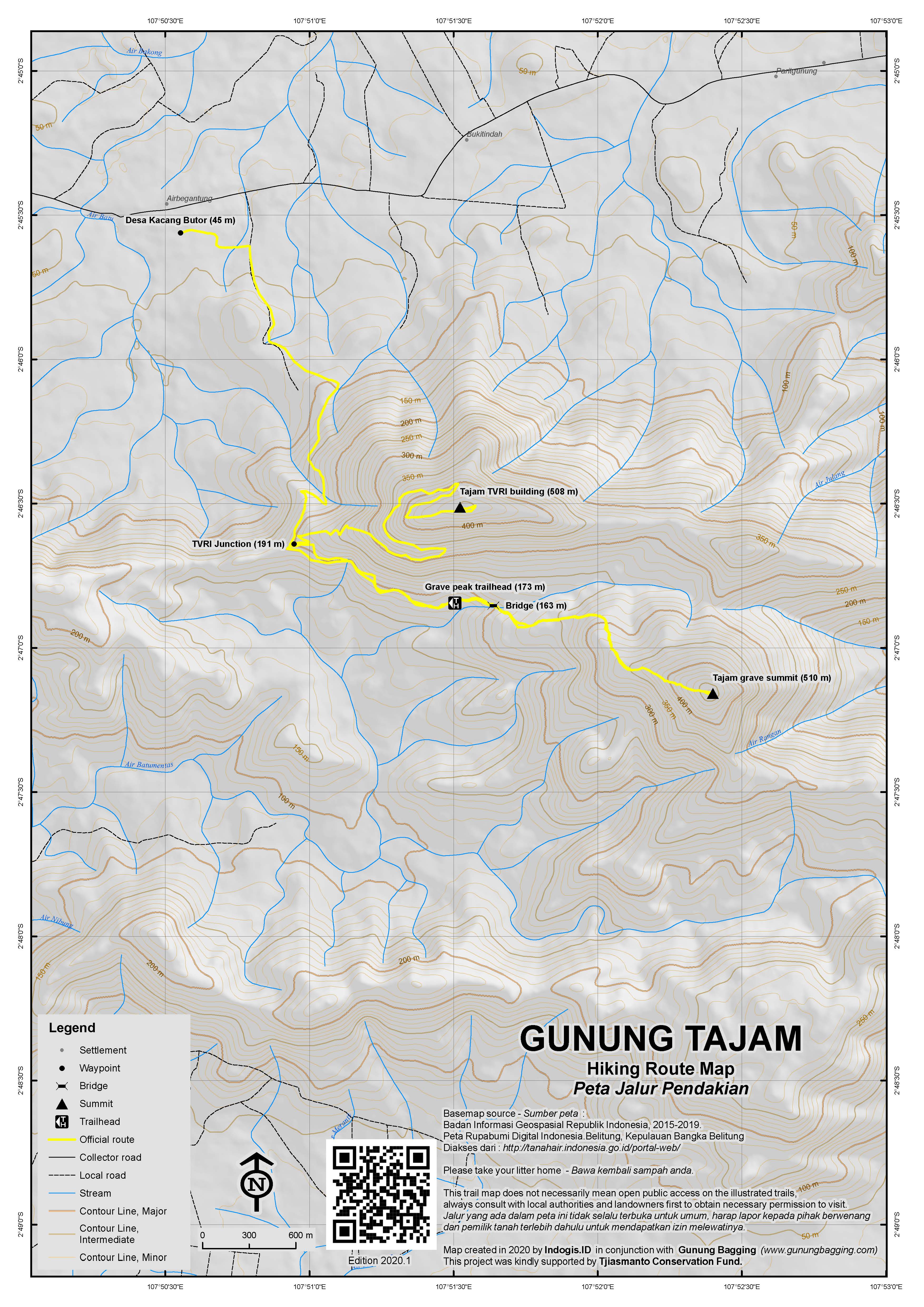
Access to the mountain range is from the main road at Kacang Butor about 15 or so km to the east of the airport junction. This takes less than an hour to reach from the main town. The minor road is well signposted with two mentions of the TVRI / Televisi tower on one of Gunung Tajam’s highest peaks. The two peaks are described locally as male and female (Tajam Laki – ‘sharp male’ and Tajam Bini – ‘sharp female’) but sources are not unanimous on which one is which. Follow this minor road as far as you can and park at the dead end near a river and bathing area (173m).
From here, a very clear trail leads up through pleasant forest to a peak with numerous ancient Muslim graves on it (from this point referred to as ‘Grave Peak’, ‘Grave summit’ or ‘Puncak Makam’), the most important of which appears to be that of Sheikh Abubakar Abdullah, who was responsible for spreading Islam on the island. You can be up at the top in between 1 hour and 90 minutes, although look out for the splendid views (and also some pitcher plants – Nepenthes Reinwardtiana) on the right side of the trail before reaching the peak itself.
At the top of the Grave summit (roughly 510m) is a shelter, a mosque, some signs plus several ancient graves apparently including that of a cat. There are no views here as the woodland is fairly dense. However it is probably the higher of the two peaks and therefore the highest on the entire island of Belitung.
You can be back down at the trailhead in 45 minutes or so, not including breaks for photos and snacks. Some may wish to bathe in the river before continuing.
To reach the other peak of a similar height (recommended both for the views and for the contrast), head back along the minor road until you quite soon reach a junction on the right with a tiny signpost for ‘TVRI 3.5km’. It is a 20 minute bumpy motorbike ride up the potholed track to the summit of this second peak (from this point referred to as ‘TVRI Tower Peak’ or ‘Puncak Menara’) or a walk of probably about 60-90 minutes. This track starts in rather poor condition and is steep in a few places but most keen motorcyclists can manage to reach the top without harming their bikes.
At the top you will be rewarded with excellent views in several directions, including to the coastline and mostly strikingly back to the Grave summit. There is a rope hanging over a wall at the last sharp bend before reaching the tower itself – this may lead to a faint trail direct to the Grave summit.
Behind the tower is an area with a small cement pillar on it. According to GPS data this appears to be the highest point of TVRI Tower Peak at roughly 508m. However, both peaks are listed as 510m on archival US Army Mapping Service (AMS) maps from the 1940s so keen baggers will be pleased to have visited both tops.
With a motorbike you can be back in town from the Tower Peak in less than 90 minutes or at the airport in about one hour.
Bagging information by Dan Quinn (May 2017)
Trail Map
For a high quality PDF version of this and other trail maps, please download from our Trail Maps page.
Practicalities
- Getting there: Numerous flights to Tanjung Pandan from Jakarta every day. Limited international flights expected before long.
- Guides and GPS Tracks: Want a PDF version for your phone? Looking for a guide? Need GPS tracks and waypoints? Gunung Tajam information pack can be downloaded here.
- Permits: Not required but take a copy of your photo passport just incase.
- Water sources: None beyond the bridge near the trailhead (roughly 163m). Take plenty even for what is a short hike.
- We recommend Safety Wing as travel insurance for overseas travellers and tourists hiking up to elevations not exceeding 4500 metres.
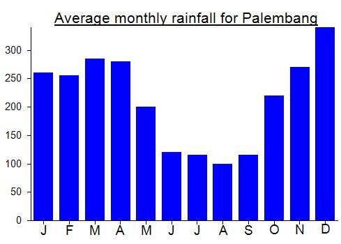
Local Average Monthly Rainfall (mm):
Location
Click on the blue arrow ![]() (top right) to see your current location on the map
(top right) to see your current location on the map
Origins and Meaning
Gunung Tajam = Sharp Mountain. Clearly describing the shape of the two highest peaks of the range.
Hi there Dan Quinn.
I am going to Belitung in a few weeks and planning to hike up Gunung Tajam. I would be so grateful for the phone number of the motorbike guy who took you there. Or the phone numbers of any drivers or guides you found helpful.
Many thanks!
SweePeck
California
I flew Wings Air for the short 30 min flight from Bangka to Belitung. Very pleasant indeed, but the Belitung airport is not yet as advanced as Bangka’s – only one tiny canteen offering a very limited range of snacks. They do have new signs up for international arrival/departure so presumably refurbishment and development is underway. It’s hard to see why this can’t be a success as the island has great beaches, very friendly people, a pretty good gunung, and is very close to Jakarta. An airport taxi into town (Tanjung Pandan) is Rp 90,000. It’s over 10km so not very expensive but as always you could find cheaper if prepared to leave the airport and search for an ojek or similar yourself.
I still hadn’t eaten and had no desire too – not because of Ramadan but because I was coming down with a pretty serious stomach problem! I checked into the Eka Inn in the centre of downtown, left my details and request for a guide with reception and told them I would get some rest. That rest lasted a good 15 feverish hours. It may have been casued by peanuts in Pangkal Pinang but can’t be 100% sure. Anyway, no news from reception at 8am the following morning and I was still feeling rough and weak, so it looked like Tajam might not happen at all.
I had a wander round the town asking ojek guys if they had climbed Gunung Tajam (also called it Bukit Tajam to which one guy replied that it was definitely a Gunung despite its low height). None had and were put off by the thought of having to drive 30km to the trailhead. Nice sleepy atmosphere in town – some interesting coffee shops and a pizza place and a large black boulder on a huge plinth at a prominent roundabout. This big rock is called ‘batu satam’ and is an very large example of a particular type of rock which is found on Belitung that was apparently formed during meteor collisions.
I had almost given up thinking about Gunung Tajam when a young chap pulled up on his motorbike to asked if I needed any help. Within 20 minutes we were on our way to the Gunung! The road in to the mountain from the main road is very pleasant indeed and very quiet. Plenty of opportunity for spotting wildlife. I saw a bright blue and green pigeon – probably an emerald dove or pink necked green piegeon. At the end of the road is a place to bathe but it wasn’t and there certainly wasn’t anywhere near as much rubbish as at a similar place on neighbouring Bangka island at the foot of Gunung Maras.
Being weak, I had to stop for a rest on the trail every15 minutes or so, but nevertheless we were up at the top of the ‘grave peak’ in no time. Some brilliant views from near the top, but the top itself is forested. The graves are several in number and appear to be a popular pilgrimage site for local muslims. But there was nobody up there when we arrived. My GPS gave a reading of 512m at its highest – a little more than the official 510m.
However, I had already seen several images online of hikers claiming to be at the top of Gunung Tajam with a panorama behind them of a potentially highest mountain. I presumed this potentially higher mountain was the one we were stood one (the grave peak), so asked my impromptu guide if we could head up to the other peak where the TVRI tower is. He was fine with this, especially as there is an asphalt track all the way up to the top so we could do it on his motorbike.
We were back at the grave peak trailhead in 45 minutes and at the signposted TVRI junction a few minutes later. I had to get off the back of the bike a few times but it took only 20min to cover the 3.5km along a bumpy and potholed road. At the top was the view I had seen before, and a few I hand’t. Beyond the large tower was cement pillar with P8 written on it where I got a GPS reading of about 508m. A little under the grave peak reading but very very similar. Either way, I had bagged both and this was my 100th bagged peak of those listed on Gunung Bagging (including both Ribus and Spesials). Not a bad place to reach a minor milestone. 100 Ribus might not be for another ten years or more!
Some guys were in the TVRI tower building and there seemed to be some active cultivation of edible plants up there – quite a lot of chillies near the doorway! From the sharp bend in the road we could see the grave peak where we had just been – a lovely view. It looked a tiny bit higher, but being forested it was difficult to tell. Just at this sharp bend is a rope leading down to a narrow path that looks a bit overgrown. It would appear to head in the direction of the grave peak so may be a way to combine both peaks on foot rather than using a motorbike (for those with extra time), but not 100% sure.
My guide dropped me back off at the airport and wouldn’t take the full fee I promised, accepting only money for fuel. Really decent folk in Belitung – no wonder Ahok comes from this friendly place.
Back in Jakarta, I had a look at various map sources. The best info I could find online was from American Army Maps from the 1940s which showed both peaks as being 510m. Not much use for determining which is the higher of the two! For now I think it is the grave peak due the both the GPS reading, the Google Earth satellite info and that unreliable factor of ‘how the grave peak looks from the tower peak’. If anyone finds out anything different do let us know! For now, if you want to be sure of having bagged Gunung Tajam, I advise you to visit both peaks!!!!