
Facts
- Elevation: 1,698 m (5,571 ft)
- Prominence: 791 m
- Peak category:
 Spesial
 - Province:
 Sumatera Utara (North Sumatra)
 - Coordinates: 2.6406, 98.8319
- Rating:


 (7 votes) Add your rating
 Loading...
Photos


Bagging It!
This peak is the highest point on the volcanic island of Samosir, which lies within the vast Toba caldera complex – a landscape formed 74,000 years ago by the largest volcanic explosion in the history of the world. It was so enormous that it is thought that the eruptions nearly wiped out all human life on the planet. Lake Toba is Earth’s largest volcanic lake, measuring a staggering 100 kilometres by 30 kilometres. From Tuk Tuk (895m above sea level), the flattish ridge of the island is clearly visible, and the highest point lies in forest just 4km (in a straight line) from Tuk Tuk.
According to Wikipedia, “Some parts of the caldera have shown uplift due to partial refilling of the magma chamber, for example, pushing Samosir Island and the Uluan Peninsula above the surface of the lake. The lake sediments on Samosir Island show that it has risen by at least 450m since the cataclysmic eruption”. In other words, the island is slowly ‘growing’ and future volcanic activity is more than likely.
Strangely, it is very uncommon for people to request a guide for a hike to the highest point of the island. There are several hikes from Ambarita and Tomok, but none of the usual routes actual goes close to the highest point of the island. Whereas much of Samosir island is deforested, a reasonable amount of forest remains on the flat summit ridge. This means that views are limited at the very top but there are some excellent views over the lake on the route up into the hills.
Farm tracks criss-cross the island but they are so bumpy that you would need either a sturdy farm vehicle such as a truck or – better still – a brave ojek driver! You can reach the top of the island in about one and a half hours from Tuk Tuk by ojek – the route leads on good quality roads through the messy market area of Tomok and then up into the hills, past a lovely viewpoint over the lake, a waterfall before reaching close to the top of the ridge. At the crest of the ridge you need to take a sharp right turn (1,560m) off the main road and along the bumpy stone farm track for about 7km. If in doubt, ask for Siulak Hosa. Once on this main stone track, head straight or stay right (do not take either of the two left turns near the beginning). Once in the forest there are only limited views but the forest is reasonably pleasant.
Later on, when you reach a flat crossroads (1,654m) with a sign for Ronggur Nhuta (left) or Siulak Hosa (right) be sure to turn right. When you reach another sign (1,641m) for 3 different destinations (straight on) or Siulak Hosa (right) be sure to go straight on instead of downhill to Siulak Hosa. By this time you are getting close to the summit but you will probably needs GPS co-ordinates to know where to stop on the track closest to the true highpoint of the island.
There are one or two large ponds near the summit which are very attractive in the early morning light. The farm tracks goes to within 150 metres of the true summit, which until recently was in dense forest surrounded by dense undergrowth. However in 2017 there had been some burning of the undergrowth making it a reasonably easy 10 minute hike up to the right side of the farm track through thick pathless forest to the highest point. GPS readings suggest it is just under 1,700m.
You can return the same way back to Tuk Tuk in about an hour.
Bagging information by Daniel Quinn (updated May 2017)
Trail Map
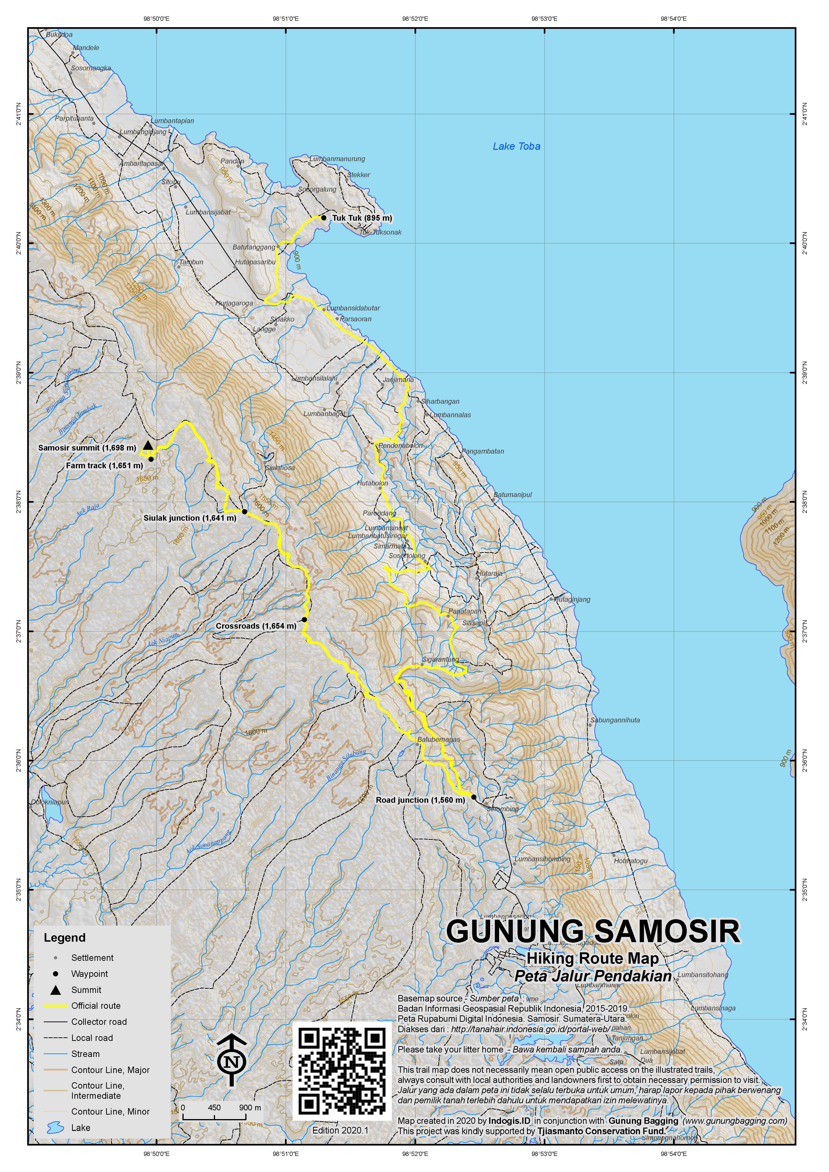
For a high quality PDF version of this and other trail maps, please download from our Trail Maps page.
Practicalities
- Getting there: The whole Toba area is one of Indonesia’s most visited places. Getting to/from Samosir from Sumatra’s capital, Medan, is straightforward but time-consuming. It is better to arrange transport in advance because the prices of taxis at Medan airport are ridiculous! It takes about 4 hours in a private car from Medan to Tiga Raja pier at Parapat (for the 30 minute ferry ride to Tuk Tuk). Shared taxis from Parapat to Medan cost just Rp75,000 per person and leave almost every hour during the day. It’s best to reserve in advance in either Parapat or Tuk Tuk. Another option since 2017 is to fly direct to Silangit from Jakarta. Silangit is less than 2 hours from Parapat and is very close to the southern end of the lake. Building work is still ongoing at the airport itself but it is going to be international eventually and transport options are likely to improve. At present (2017) you can hire a car and driver to Parapat for Rp400,000 (or if alone and very lucky just share a car with any others heading in the same direction for a fraction of the cost) or walk to the main road (1.5km away) and get in a cramped minivan to Parapat (Rp40,000 per person). The last boat over to Tuk Tuk leaves Parapat at around 6 or 7pm and the first one back is at 6.45am.
- Guides and GPS Tracks: Want a PDF version for your phone? Looking for a guide? Need GPS tracks and waypoints? Gunung Samosir information pack can be downloaded here.
- Permits: None required.
- Water sources: Not needed if you take an ojek all the way! Otherwise, take a couple of small bottles for the ridge walk.
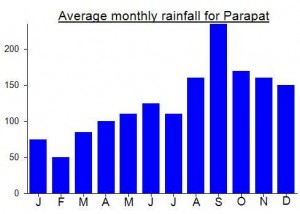
Local Average Monthly Rainfall (mm):
Location
Click on the blue arrow ![]() (top right) to see your current location on the map
(top right) to see your current location on the map
Update July 2025: just returned from a family trip to Lake Toba, when I checked into the hotel I enquired about getting to the top of the mountain and was told that it was not possible due to a landslide. On the last full afternoon of the trip I decided to hire a scooter and see how far up I could get using the excellent georeferenced pdf map available here.
I can confirm that there is a very large landslide that has taken out the whole bitumen road before the road junction shown on the map. However, the road is passable (for motorbike or becak, just) due to a makeshift wooden bridge that has been built. Pretty hairy if you are not used to Indonesian safety levels. I was able to follow the map up onto the ridge and into the trees. Past the crossroads the track gets very rocky and slow going (but still doable for the adventurous). I decided to turn around about halfway between the Crossroads and Siulak Junction as I was alone on a rented scooter and concerned that if I popped a tyre then no-one would know where I was for a long time. Would definitely recommend that anyone who is interested in reaching the summit decide to be persistent and ask around for an ojek willing to take you up there.
Already looking forward to a future trip to Lake Toba when I can give it another go.
Hi Dan, I’m in Medan & this looks like a good one. Do you have a gps track & coords of summit pls?
Kml file available in the box at the top of the page. GPS tracks on the GPS Tracks page under Resources.
Enjoy, let us know how you get on but also consider nearby Pusuk Buhit for great views and a proper but easy hike. CHEERS.
Just back from a successful ‘ascent’ of Samosir, taking all of 15 minutes from the farm track! After visiting the area at dawn 6 years ago and staring at the dense and thorny undergrowth I was happy this time to see that this undergrowth was no longer quite so dense (but still fairly thorny).
As last time, I arranged an ojek guy from Bagus Bay in Tuk Tuk but at a more sensible hour of 9am so a very reasonable Rp200,000 (for 3 hours total – you might need 4 just to be on the safe side). Nice chap too – Sabar 081262070374.
There are quite a few landslide areas on the road up past the waterfall and some parts of the farm track itself are either unstable or with thick mud pools. I definitely recommend taking an ojek or – even cheaper – hiring a motorbike for the day yourself (though you’ll have to clean it afterwards). Look out for eagles soaring above the road up near the waterfall.
It only takes 30min to reach the sharp right along the top of the ridge, but it is fairly easy to miss. It’s a simple stone track which is very uneven for all of the 7km or more.
The actual summit itself offers no views but I did see a monkey thrashing around in branches in the distance. The summit is unmarked at present but should be obvious if you have the location stored in your GPS.
Getting there and back…. I decided to fly to Silangit (currently twice a day to/from Jakarta with Sriwijaya) which is eventually going to be the Lake Toba International Airport. Not many people have heard of it yet and you might need to say Siborong-Borong (nearby town). It is still a small airport and the area is pretty rural with grubby uninspiring yet friendly warungs selling pop mie etc (none of them have menus) – quite a comedown after the culinary delights of Tuk Tuk. Though what Silangit will look like 5 years from now is an interesting question.
Getting to Toba from the airport is fine if you can speak Indonesian or if you have 3 friends with you to share the cost of a driver. For single travellers without local language skills it is still rather difficult as you either have to get to the junction 1.5km away and hopefully hop on a minivan towards Parapat or else cough up Rp400,000 for a private car/driver from the airport. On the way there I shared a car with another passenger (we paid 200 each – a fair bit more than the more popular but longer Medan-Parapat route).
The return journey…..After several calls to transport companies regarding a seat in a shared car for my return to Silangit airport from Parapat and them all saying I would need to pay Rp400,000 as they didn’t have any other passengers, I decided to try local buses. This means standing at the main road outside Alfamart opposite the police station in Parapat and waiting to see what comes along. I didn’t have to wait too long for a minivan heading to Tarutung which would be going along the main road 1.5km from the airport. Rp40,000 which is pretty good value. I ended up paying him Rp50,000 as he dropped me right at the airport rather than just at the junction.
You do wonder if most people will see the advantage in flying to Silangit at present when the flight prices are a few hundred thousand more than to Medan (more flights and more competition) and the transport options much more limited for single travellers compared to Medan. On your own and not using the minivan option and not getting lucky meeting other travellers willing to share the cost of a car to Parapat and you could be looking at an extra million rupiah return when flight prices are taken into consideration. And this just in order to save an extra 2 hours each way in a car. However, on balance I would say it is worth flying to Silangit, mainly because it will slowly improve as more flights use the airport and it makes a change if you’ve already been to Medan before.
Ultimately what the authorities should be doing is developing the Balige to Onan Runggu (Samosir) ferry which currently only runs once a day and is not well-publicised to tourists. This would mean just 30 minutes from Silangit to Balige (affordable either by taxi or ojek or minivan) and then onto the boat across Lake Toba. It would also mean avoiding the congested Parapat pier (‘Tiga Raja’) which is on the wrong side of a crowded market.
Toba itself was wonderful, as always. Perfect temperature (900m above sea level), plenty of beer available at low prices, friendly people, good local music and culture, great scenery and for a vegetarian like myself some simple yet absolutely brilliant food options that are sorely lacking in most other parts of Indonesia. Do try the avocado and banana juice at Bagus Bay – an inspired combination! The Parapat-Tuk Tuk ferry is currently a very reasonable Rp15,000 per person for the delightful 35min crossing.
This ‘hike’ is one of the stranger ones I’ve undertaken! From one of the bars in Tuk Tuk I arranged a guide/ojek for 400,000 for 4 hours (I thought enough time to get there and back plus an hour or so to explore the actual summit ridge). I didn’t have much time so we arranged to meet outside my hotel at 4am so we’d be at the top for dawn and I’d be back in time to get the ferry over to Parapat and bus back to Medan.
By 4.15am the guide still hadn’t shown up so I gave him a call. Still in bed! He arrived with a friend 20 minutes later and could barely stand up. He had been at a nightclub and was clearly drunk and under the influence of the local magic mushrooms or similar!!! Not the most reliable of people!
Anyway, his less drunk friend agreed to take me up to the top of the mountain (although they found it very odd and the first time they could remember that anyone had requested to go to the highest point of Samosir island).
I was armed with my GPS with the summit co-ordinates and in just under 90 minutes we were as close as I thought we could get to the summit – about 20 metres lower than the densely forested top which lay just over 100 metres away.
Looking on Google Earth, the trail actually loops round the true peak, so there is a very small chance that the true peak is accessible from the other side but I very much doubt it as there would be no logical reason for locals to make a trail through the jungle just to be at the true high point of the island. It’s a nice, peaceful summit ridge with some interesting wildlife and excellent views over the lake further down on the main road. Although it’s not the most amazing mountain I’ve ever visited it is a worthwhile objective for hikers holidaying in Tuk Tuk and the rate of logging sadly means that the summit will probably one day be accessible (the upside of this would be the tremendous views made available).
On the way back it’s worth stopping to have a look at the King’s Tomb between Tomok and the turning for the Tuk Tuk peninsula. The best views of the mountain itself are from the road round the Tuk Tuk peninsula or indeed from the boat crossing the lake from Parapat.
It’s interesting to note that Samosir is not a true island as on the west side near Pangururan the only thing which separates the ‘island’ from the ‘mainland’ is a narrow manmade canal.
Hello Dan 🙂 Thanks for your post. I found it both informative AND amusing. Now I have a question here. You said in your post: “On the way back it’s worth stopping to have a look at the King’s Tomb between Tomok and the turning for the Tuk Tuk peninsula.” Do you mind telling me more about this tomb via email? Thanks a bunch Dan.
-arya