
Facts
- Elevation: 1,570 m (5,151 ft)
- Prominence: 1,539 m
- Ribu category:
 Kurang Tinggi
 - Region:
 Kalimantan Barat (West Kalimantan) /
  Sarawak
 - Division: Bahagian Kuching
- Coordinates: 1.7208, 109.6686
- Rating:

 (2 votes) Add your rating
 Loading...
 - Other names: Mount Kanyi, Rumput, Pueh, Poi, Poe. Listed as Gunung Bentarang on the Bakosurtanal map.
- World Ribus ID: 69080
Photos


Bagging It!
This large mountain range is on the border of Malaysian Sarawak and Indonesian West Kalimantan and despite being little-known is one of Borneo’s most prominent mountains. It is an extensive, long ridge with various different peaks, the highest of which is Gunung or Bukit Kanyi which is most easily hiked from the Malaysian side.
The range recently became a National Park on the Malaysian side, known as Gunung Pueh National Park. This name comes from one of the numerous different peaks. According to a reliable twentieth century US military map, the main peaks, from north to south are as follows:
Gunung Pueh, 1,297m.
Gunung Bentarana, 1,310m.
Bukit Kanyi, 1,570m.
Gunung Rumput, 1,505m.
Gunung Tempurung (Tempoeroeng), 1,346m.
Gunung Kalijau or Kalimaoe, 1,216m.
The mountain range is better known for its waterfalls which see local visitors most weekends, but a trek to the top of Kanyi is actually possible as a day-hike, assuming you are both experienced and happy to set out at or before first light (before 7am).
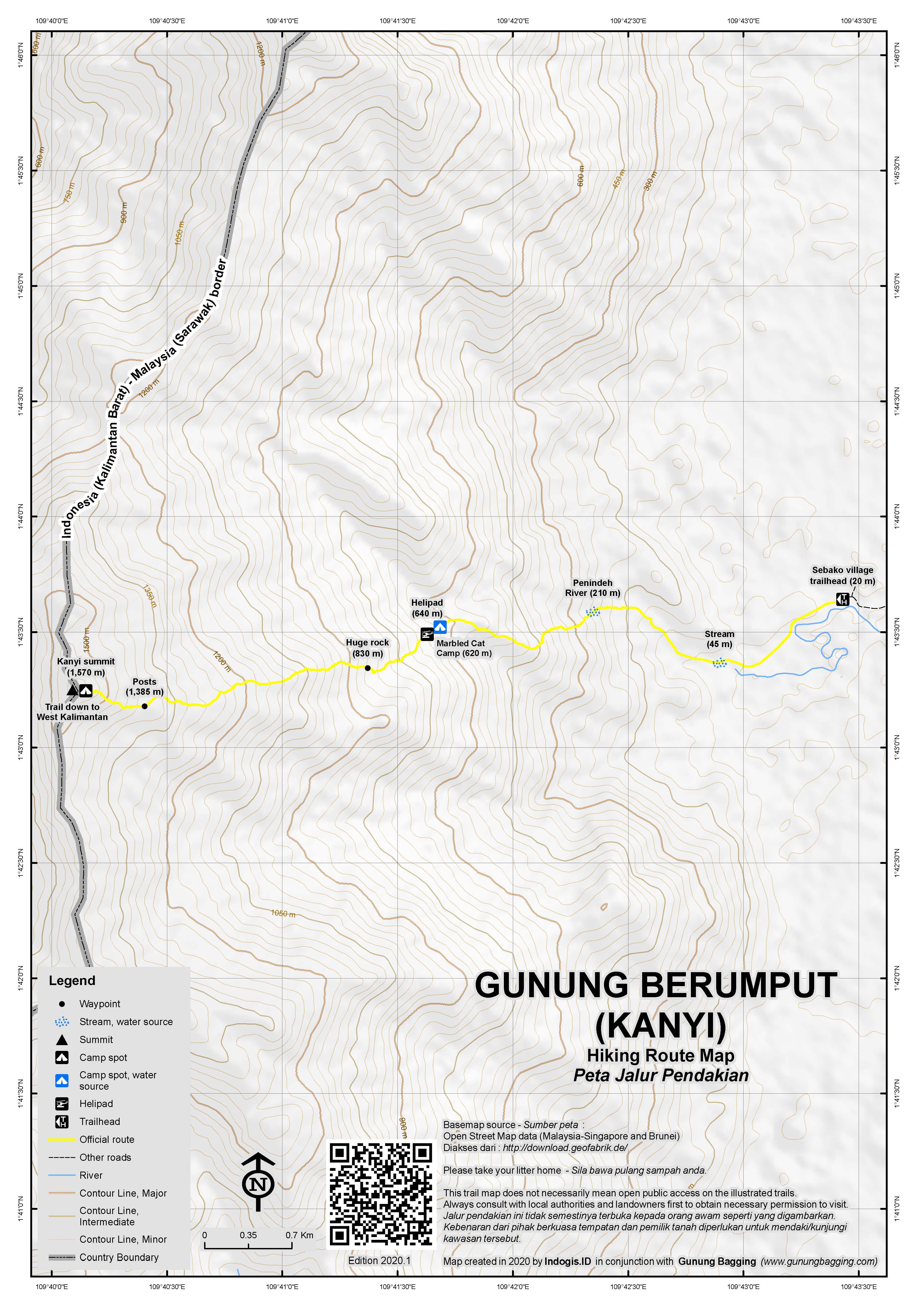
The trail begins in the large village of Kampung Sebako (just 20 metres above sea level). At the entrance to the mini hydro dam, take a small and often slippery trail leading to the right, following water pipes much of the way until you reach the Penindeh river crossing (210m). This crossing is a little tricky, with numerous slippery rocks to contend with so take your time over it and be careful.
After the river, the trail leads steeply up an this is perhaps the toughest section. Before long, the gradient eases and the trail feels remarkably pleasant. It remains like this for the majority of the way to the summit. Listen out for monkeys and hornbills.
The next major landmark is Marbled Cat Camp (620m), a cluster of wooden buildings assembled in 2018 as part of a major scientific research project here. It should have taken you around 2 hours to reach this point. There is a kitchen complete with table and chairs, toilets, plus photographs and maps on an information board. As you will see, like nearby Gunung Gading, this is a great spot to potentially see Rafflesia if you are there at the right time of year (the best time is usually November to February).
Beyond the camp is the helipad (640m) constructed simply out of timber and offering great views back over to nearby Gunung Gading. After the helipad, the trail once again enters forest. A huge, impressive boulder (830m) is reached in less than one hour from the research station and its overhang is so great that this was the preferred camping spot during multi-day hikes before the Marbled Cat Camp was built. This point is roughly halfway to the top, both in terms of elevation and time required.
The trail continues to lead rather gently up the mountainside and the next major landmarks are a couple of thin cement markers (1,385m). There are more of these at the summit itself, which you should have reached in 5-6 hours total from the bottom. It’s a clearing, with a tall and sturdy triangulation pillar like those often found in Kalimantan such as on Gunung Niut.
Just as on Gunung Penrissen to the south of Kuching, you are now standing on the border of Malaysian Sarawak and Indonesian West Kalimantan. On one side of the pillar is the inscription ‘SWK MAL’ and on the other ‘IND’. There is also a small marble plate with ‘P139’ written on it which is typical of Indonesian triangulation numbering. Later writing includes ‘C37’ and a few local slogans from previous hikers. The construction of this pillar may well have been a joint effort by Malaysian and Indonesian teams. This would have been many decades ago but strangely the Indonesian Bakosurtanal map labels this peak ‘Gunung Bentarang’.
Although the vegetation obscures the views, the summit is a nice place to rest for a while. There are quite a few pitcher plants here, especially if you head just a couple of minutes down the Indonesian trail which is rather overgrown in 2019 to a small forest clearing. Here you may see a bit of red graffiti on a tree by a Kostrad Unit (Indonesian Army) who visited here in 2012 and appear to be linked to the C37 on the pillar.
It is certainly clear that Kanyi is higher than all the other tops on this long ridge, and the high point currently marked Gunung Rumput on Google Maps and Google Earth is actually Kanyi. Given that there are so many different names, we have decided for now to refer to the mountain range as Berumput or Rumput and the actual highest peak as Kanyi. Gunung Pueh as a name for the range seems to be known on the Malaysian side but less so on the Indonesian side, perhaps because there is also a River Pueh and Pueh village on the Malaysian cost directly north of the range.
As for the trail from the Indonesian side, this starts at Batu Hitam but not much is known about it. According to Malaysian guides, Indonesian poachers are often seen venturing over the border but it remains a rather obscure mountain to most Indonesian hikers!
It should take fit hikers with day packs no more than 4 hours to descend back to Kampung Sebako.
For those who have a bit of extra time available, there is an excellent viewpoint for the entire range at Bukit Gondol, Pugu beach, near Lundu. A little 85 metre high hill but with fabulous views, especially in the late afternoon and for sunset. Pueh/Berumput/Kanyi is the backdrop, with a couple of minor peaks in the foreground, according to old topo maps Gunung Tamin Menari and Gunung Tamin Tungku, just to the east of Gunung Bentaran.
Bagging information by Dan Quinn (July 2019)
Trail Map
For a high quality PDF version of this and other trail maps, please download from our Trail Maps page.
Practicalities
- Getting there: The nearest city is Kuching, and Kampung Sebako is just under 2 hours by car from there. The Indonesian starting point at Batu Hitam requires a longer journey from major cities in Indonesia such as Pontianak or Singkawang.
- Guides and GPS Tracks: Want a PDF version for your phone? Looking for a guide? Need GPS tracks and waypoints? Gunung Berumput information pack can be downloaded here.
- Permits: Currently not formally required on the Malaysian side, but take a local guide with you from Kampung Sebako.
- Water sources: Available at the river crossing (210m) and a short distance from Marbled Cat Camp (620m) on the Malaysian trail from Sebako. None at the summit.
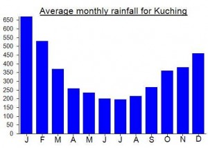
Local Average Monthly Rainfall (mm):
Location
Click on the blue arrow ![]() (top right) to see your current location on the map
(top right) to see your current location on the map
Origins and Meaning
‘Berumput’ means ‘grassy’ in Indonesian.
Pingback: ATLAS OBSCURA: Seven Points of Interest in Sarawak – UTPWrig
This range had been near the top of my list for many years, so very pleased to have finally visited the top at the weekend and surprised to have been able to do it as a day hike without too much worry. It was another mad weekend from Jakarta, with no direct flights to Kuching so having to go via KL in both directions.
As I had Saturday afternoon free I went out to Bako National Park for a warm-up. Very pleasant indeed – lovely trails, great views over to the Santubong peninsula. A little too busy perhaps – if I come back I’ll spend a night there mid-week during the rainy season.
The guides in Kampung Sebako at the foot of Kanyi are great – Tony and his brother Julius. I explained I needed an early start as I had to get back to Jakarta the same day (!) so co-hiker Ken picked me up before 4am in Kuching and we were ready to start hiking before 6am.
A fair bit of thunder around, and overcast skies. This was actually a blessing as it meant slightly lower temperatures, and aside from the views at Marbled Cat Camp there are not that many panoramas to miss anyway.
Wilson Chin and friends reached the summit of Kanyi in 2015, on a 3 day mission with really poor weather. Mykhailo Pavliuk ran to the top in early January 2019 in just 2 hours and 32 minutes! We were hoping to be somewhere in the middle and my prediction of 5 hours up and 4 back down was pretty accurate. We had light rain at times and one or two leeches but given the gentle gradient this is a really pleasant hike aside from the slippery rocks at the river crossing. Perhaps one of Borneo’s easiest Ultra-prominent peaks. Sad to have to leave for Jakarta again so soon.
well, this mountain is one of my target to explore.
Hope this year I can climb it from Indonesia
For Rumput/Berumput – or Pueh as it is known over in Malaysia – I had little information to go on but one contact at an adventure travel company in Kuching asked to meet so we could discuss a 3-day trek to the peak with one of his guides from the local area called Manshur. I was ready to ask him all the usual questions and took some extra money to prepare for paying a deposit. Well, I waited and waited for this contact to meet at the arranged place and he never arrived, even late, and never sent a message until the following day to try to negotiate a second meeting. With lack of reliability like that, how can one trust such an individual to organize a 3-day trek?
As with all multi-day treks in Sarawak, the cost is likely to be prohibitively high for ordinary travellers who are on their own or even in a small group. Your best bet is perhaps to try asking in Lundu.
You could try Manshur +60 138448726.
Otto Steinmayer who lives in nearby Lundu notes that in the 1860s the naturalist Odoardo Beccari climbed Pueh and spotted Rafflesia (very famous at Gunung Gading nearby).
Dan, thanks for the info.
My team and I plan to climb berumput on the end of Aug 2017, and hope that we are able to reach Manshur to get him to guide us to the summit.
Currently trying to find out whether this is best tackled from the Indonesian or Malaysian side. Not much information except
the following on Wikipedia…
“Mount Pueh was known to biologists for the collections made there by Eric Mjöberg (1882–1938), a Swedish naturalist, who was Curator of the Sarawak Museum between 1922–1924. Mjöberg’s herpetological collections from Gunung Pueh between October to December 1923, and other localities in Borneo, were reported by Smith (1925). Mjöberg, unfortunately, left little by way of written records, of his ascent of Pueh and the collections he made.
In 2002, an exploration was organised to find out about the area. During a scientific expedition to the summit of Mount Berumput on 6–14 May 2002, 26 species of birds, four species of bats and one species of rat were observed. The only montane endemic recorded in this expedition is the Grey Fruit bat, Aethalpos alecto. Based on their tracks and other signs, wild pigs (Sus barbatus) were common near the summit. Three Arcuate Horseshoe bats (Rhinolopus arcuatus), previously recorded only from Bungoh cave near Bau in Sarawak.”
Looks like the 800m+ peak of Gunung Santubong near Kuching is worth a climb too so I’ll probably attempt from the Malaysian side unless I hear otherwise….