
Facts
- Elevation: 1,682 m (5,518 ft)
- Prominence: 1,639 m
- Ribu category:
 Kurang Tinggi
 - Province:
 Kalimantan Barat (West Kalimantan)
 - Coordinates: 1.0025, 109.9333
- Rating:


 (8 votes) Add your rating
 Loading...
 - World Ribus ID: 69067
Photos


Bagging It!
UPDATE: As of 2017, hikers need to email the relevant authorities below to request permission to hike Gunung Niut.
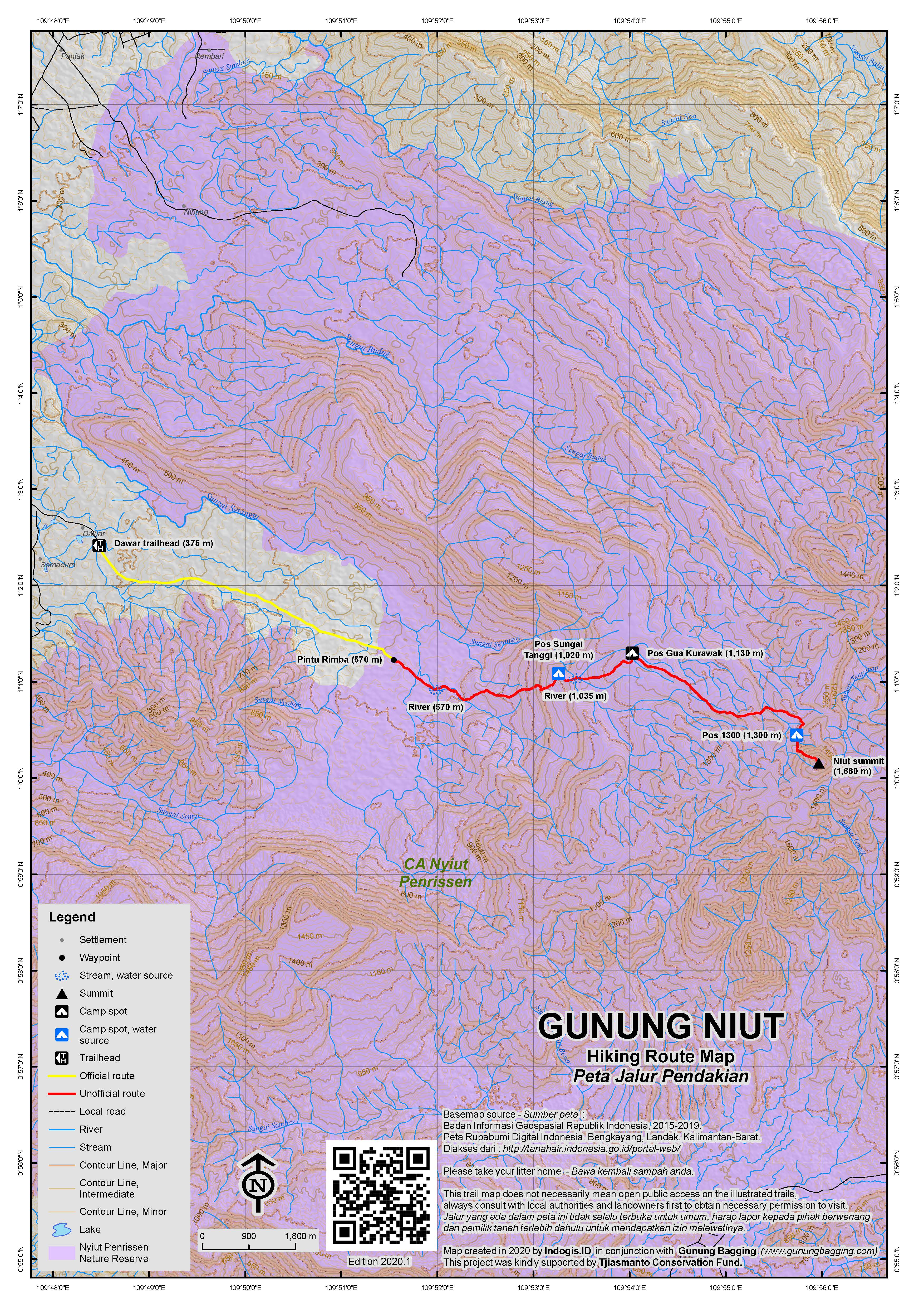
This peak gives its name to the Gunung Nyiut-Penrissen Nature Reserve which can be reached by public transport from Pontianak. Take a bus to Dawar via Sanggauledo. From Dawar it is about 10-12 hours of hiking to the summit so it’s best to camp at a spot at 1,300m (which is about 90 minutes before the summit) then get up early on the second day to reach the top for first light. The highest point is marked with a cement pillar (P123) and the best views are to be found about 20 metres below this point.
The Nature Reserve stretches to the Malaysian (Sarawak) border where Gunung Penrissen, the peak that gives the Nyiut-Penrissen Reserve the second half of its name, is located.
The trail from Dawar (375m), leads eastwards to the Pintu Rimba or forest entrance (570m) which is where the Nature Reserve begins and the point at which permission is required for access from the authorities in Pontianak or Singkawang. If permission is obtained, you can proceed via Pos Sungai Tanggi (1,020m), Pos Gua Kurawak (1,130m) and Pos 1300 (1,300m) to the summit itself.
About a decade ago, red grafitti on the summit pillar suggested the mountain was 1,687 metres high. Certainly the previously published summit height of 1,701m (which remains the official elevation) seems a little bit higher than GPS devices have recorded. One GPS reading from a local group gave a reading of 1,682m and this sounds pretty accurate based on other sources.
For a local guide, you could try Pak Ajam on +62 85245350960
Trail Map
For a high quality PDF version of this and other trail maps, please download from our Trail Maps page.
Practicalities
- Getting there: From Singkawang it is 1.5 hours to Bengkayang. From Bengkayang to Dawar is another 1.5 hours.
- Permits: As of 2017, you must request permission to climb from BKSDA Kalimantan Barat, preferably in advance. This can be done via email to ksda.kalbar@gmail dot com or you can visit the office in either Pontianak or Singkawang. Note that if you are not conducting scientific research they may or may not allow you to hike. You should also register in Dawar where you will probably have to take a local guide with you.
- Water sources: Plenty of water sources in the forest for most of the hike.
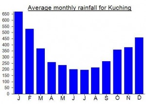
Local Average Monthly Rainfall (mm):
Location
Click on the blue arrow ![]() (top right) to see your current location on the map
(top right) to see your current location on the map
Had a message this week from a keen local hiker Benjamin who with his team successfully reached the top of Gunung Serahang (1,445m) which lies to the west of Gunung Niut. From what I can gather there are no views from the top as expected due to dense forest cover. Still, great to hear about a trip to an unfrequented place.
Sadly, Gunung Niut has recently joined the growing list of mountains that hikers are technically banned from setting foot on. I heard from local hikers that you must request permission, so I put together a document detailing my planned trip along with my background information and a risk assessment. After waiting for a response for nearly a week I was told permission had been rejected because I was not conducting scientific research. Funny how many local student hiking groups go up Niut every year and will almost certainly be there later this month on August 17th as is the tradition. A local contact told me this was the first time permission to hike had been rejected as far as they had heard, so either it was rejected because I am a foreigner or because they are now implementing these crazy new rules about nature reserves which ban hikers from entering. This is all based on a weird philosophy that sees humans as merely destructive and separate from all other species (which are of course free to enter as they see fit).
If Indonesia wishes to encourage more tourists to places other than Bali then they will have to do a lot better than this. Amazingly there is a middle way which allows responsible hikers to visit mountain summits in small numbers, and pay local people to guide or porter instead of chopping down the forest. This legislation is of serious concern for all lovers of the outdoors in Indonesia. The more places humans are banned from exploring (whether by corporations or government departments), the more impoverished and regimented our existences on this planet are. But try telling that to a bureaucrat.
perjalanan yang sangat mengesankan,kami ingin informasi mengenai bagaimana perasaannya setelah melakukan pendakian?
adakah hal-hal menarik yang di jumpai?
suatu saat,saya ingin melakukan perjalanan ke gunung niut.
terimakasih telah memuat perjalanan ke gunung niut dalam situs ini.
Some great, detailed information from Thomas Ulrich on his expedition to Niut – including a descent down the other side and over the border into Malaysia….
Gunung Niut assessment report
Field work: June 2-7
Report writing: June 29, 2012
Assessment team: Pak Ujok (Project driver GIZ RED Singbebas), TU, tourism consultant, Pak Frans, Dinas Pariwisata Bengkayang (only June 3-4)
Pak Ajam (local guide), Pak Lucas (porter only June 3-4)
Transport: We use the project car to get from Singkawang to Dawar, the starting point of the Gunung Niut climb. We travel back from Entikong by public bus
Preparation day, Saturday June 2, 2012
TU prepared a shopping list for food and some equipment (for Ujok and Pak Frans). I brought my own tent, stove, cooking gear, mat, and sleeping bag as well as the usual outdoor gear.
Ujok was in charge for the shopping and he managed to get all items in Singkawang. I prepared print outs of Google Earth and some other maps of the area.
Day 1, Sunday, June 3, 2012
We leave at 7AM and drive from Singkawang to Bengkayang (1.5hrs) to pick up Pak Frans from Dinas Pariwisata Bengkayang. We follow the main road north until Sanggauledo. There we turn right towards Dawar. From Bengkayang to Dawar it takes another 1.5 hrs. Dawar is the last village at an elevation of 375 m and 15 km to the west of Mount Niut. Before we arrive in Dawar a heavy downpour starts. We first visit the village head. He has a very good knowledge of the Mount Niut area and compared to our guide he is able to read maps and to predict walking times. After this briefing we proceed to the house of Pak Ajam, our guide. Pak Ajam has been informed about our coming (Mobile Phone +62 85245350960) and he was prepared. Everybody was skeptical when I mentioned that I would like to cross the complete mountain range until to the village of Entikong in the east (this is the only visa on arrival boarder crossing with Sarawak (Malaysia). So far no other climbers of mount Niut had such an intention. For the locals it was very difficult to estimate the time needed for this trip because they believe that visitors can not walk as fast and as long as the locals.
Since Pak Frans from the tourism office was worried to carry his own bag we decided to take a porter as well. An hour later everything was packed and we left Dawar at 3PM to climb up to the small hut (Pondok) at the border of the protected forest.
We arrive at 5PM at the hut of Pak Ajam (elevation 545 m) , still enough time to wash in the clear creek and to prepare the dinner. In dry weather conditions the place could be reached by motorbike taxi (Ojek). The clearing where Pak Ajam has buildt this hut is still new and was created by slash-and-burn practice. We collect some cassava leaves for the dinner and start the cooking fire.
Day 2, Monday, June 4, 2012
We get up at dawn and finally start to hike at 7AM. It is highly advisable to use plenty of strong mosquito repellent on all exposed skin, the legs, socks and shoes and to regularly apply new repellent at each rest in order to minimize the number of leeches bites. Despite this you can be sure that a number of these nasty bloodsuckers will get what they are starving for.
For the first hour the trail follows a river and there is little incline. Watch out for monkeys, we heard Gibbons in the early morning hours. The single trail from Dawar up to the campsite at the base of the peak is unexpectedly well defined and the guide rarely used his bush knife.
After two hours the climb becomes steeper for the first time. Pak Frans is already quite exhausted and soon after he suffers terrible cramps in both legs. We still manage to reach the riverside campsite at an altitude of 1020 m. There we cook noodles and massage the legs of Pak Frans. Since he is already very exhausted and this is only half way up to the mountain base camp I decide that it makes no sense for Pak Frans to continue. Pak Lukas, the porter will make sure that Pak Frans can safely descend to Dawar. We repack and leave at for the summit camp site at 1PM.
The remaining three of us can now climb in a faster pace. Along the way we find pitcher plants. About an hour after the riverside campsite a small trail braches to the left to a stone cliff with a rest place under an overhang at an altitude of 1130m. From here it takes us another 2 hours until we finally reach the campsite at the foot of the peak. We are quite tired until we arrive there and at 4:30PM and we immediately start to set up the camp. While our guide is building a makeshift shelter covered with a plastic sheet I’m pitching up my tent. It is advisable to bring along a gas-or fuel stove since it can be quite hard to light a fire in the very humid forest. The campsite is at an altitude of 1290 m, while the actual summit is at 1660 m. From the campsite to the summit the terrain is steep, like a real mountain. 40 m down from the campsite there is a small stream with clear water, ideal for washing and cooking. We have an early dinner and go to sleep short after.
Day 3, Tuesday, June 5, 2012
We get up at dawn and cook some noodles before we start for the summit. Since we will come back to campsite after the summit we only carry a bottle of water and some dry clothes.
The climb to the peak takes a little more than an hour, but the trail is steep and in some parts a little slippery. We reach the peak at 7:15 AM. The highest point doesn’t offer much of a view, the best location is about 20m below the peak where the view to the western direction is unobstructed and you can see vast forest area.
On the peak we also can get a reasonably strong mobile phone signal. At the campsite there is no signal at all.
We descend back to the campsite (40minutes) and cock some rice while we strike the tent and pack the bags.
With our plan to descend to the east side of mount Niut we still have many hours of hard jungle trekking in front of us. Pak Ajam, our guide doesn’t want to predict whether we can reach the first village or spend another night in the forest. My plan is to reach the village.
We leave the campsite around 9:45 AM. After descending for 20 minutes we leave the Dawar trail and turn east. This route is crossing the northern ridge of Mont Niut before descending to the East. The trail is only used by local hunters and is not easy to find. For this route there is a no go without an experienced local guide, even if you use the GPS track data it will be difficult to stay on the trail.
We have a lunch break at a river crossing under the overhang of a small cliff at around 12 PM. Ujok has not applied mosquito repellant on his shoes and socks and he is busy to remove a number of leeches. We continue for another 3 hours to have a break at river crossing.
Before we reach this point Ujok fell from a slippery boulder and heart his knee. Furthermore he is exhausted, and I had to make sure that eats more snack food than what he actually wanted. The trail is following the left hand side of a river valley and although the valley descends the trail is going up and down. Half an hour later Ujok is getting very week. Pak Ajam and I alternately carry his bag. At 4PM we reach a clearing with an old cocoa and no longer maintained cocoa tree plantation. From here it takes us another hour until we reach the village of Kampung Kuningan by 5:30PM. Here we can stay at the house of a relative of our guide. After dinner we go to see the village head and soon all the young men from the village are coming to meet us there. Beside some Missionary pilots (there is a small airstrip where cessnas from the Missionary Aviation Fellowship can land) the villagers in this very remote place (no road and no river access) don’t see many foreigners.
We are more than tired and go to sleep early. For the next day the plan is to walk until the village of Suruh Tembawang at the Sekayan river. From Suruh Tembawang to Entikong there are river boats that normally leave in the morning hours.
Day 4, Wednesday, June 6, 2012
We leave Kampung Kuningan at around 7AM. The local villagers mentioned that it will take 4-5 hours to Suruh Tembawang. This part of route leads trough farm-and bush land with some rests of rain forest. We reach the Sungkung airstrip at around 9:30 AM and soon after Sunkung village.
We continue until the village of Kampung Pool where we arrive at 11:30. From here the last 6km down to Suruh Tembawang motorbike taxis are available. We wait at the house of local teacher where we get coffee. Half an hour later 3 motorbikes are ready to take us to Suruh Tembawang. We agree on IDR 25,000 (US$ 2.70) for each bike and enjoy the ride on the narrow trail. By 1PM we arrive in Suruh Tembawang at the Sekayan river. We actually didn’t expect to get a boat ride at the same day, but we are lucky and can join a charter boat trip from a group of government health officials. The trip to Entikong takes about 3 hours, at low water levels it might take 1-2 hours more. Half way down to Entikong a heavy down poor starts and we are soaking wet when we arrive in Entikong.
From the boat landing in Entikong we walk first to the bus terminal to learn about the departure time of the bus back to Singkawang. After this we check in at a simple Losmen (small, local hotel). After this we enjoy dinner at a Padang food restaurant.
Day 5, Thursday, June 7, 2012
At 6 AM sharp we are at the Entikong bus terminal. Since hardly any passengers have arrived yet we still have time for a noodle breakfast at a local food stall. At 6:45 AM we finally depart for Singkawang on an endless trip with hundreds of stops….By 4PM we arrive back home in Singkawang.