
Facts
- Elevation: 1,265 m (4,150 ft)
- Prominence: 1,022 m
- Ribu category:
 Kurang Tinggi
 - Province:
 Jawa Timur (East Java)
 - Coordinates: -7.8456, 114.3629
- Rating:

 (4 votes) Add your rating
 Loading...
 - World Ribus ID: 69210
Photos


Bagging It!
The relatively small, dormant volcano of Baluran is located in Baluran National Park on the extreme NE tip of Java. Being in a rain shadow, the region is extremely dry with an African savannah atmosphere. The mountain lies NW from Banyuwangi (the crossing point to Bali) and SE of Asembagus on the highway from Surabaya. Despite being a National Park and a relatively small mountain, the peak is rarely climbed. The track is probably overgrown and guides may be needed to cut the track. So you should arrange the climb well in advance.
The last reported climb was by rangers in June 2009. Requests via email and SMS to hike to the summit in 2016 and 2017 were rejected with a response that the summit area is just for special research interests only. You can try phoning or texting the Park on 082332213114. Good luck with getting a positive response!
The highest peak (some say Gunung Aleng at 1,256 m though the Bakosurtanal map suggests otherwise with a southern peak at 1,265 m) is (or would be) climbed from the western side starting at Karang Tekok (aka, Sumber Waru). This is the last village along the highway from the west, i.e. the Surabaya side, and 12 kms after Asembagus before ascending into teak plantations in the foothills of G. Baluran. The Karang Tekok villagers traditionally collect forest products (i.a., kemiri nuts, honey) from within the Gunung Baluran complex and know the mountain well. They are probably the most experienced in acting as guides. (We say ‘probably’ because we have not yet climbed the mountain from Karang Tekok.)
A permit to enter the Park (and to climb the peak) should be negotiated/obtained from the Baluran National Park office at the main entrance to the park at Batangan, 35 kms from Banyuwangi, or 21 kms from Karang Tekok. PT Perhutani, the state-owned forestry company, manages the teak plantations on the western side of the mountain. You may also wish to enquire with guides at Karang Tekok and/or PT Perhutani officers about permits.
The trail leads through teak plantation and then through increasingly dense forest to the crater rim. Apparently the trail is overgrown and faint and may require a whole day to reach the summit because of the need to cut the trail; therefore an overnight camp maybe necessary. Although the peak is not particularly high, in clear weather you can see the islands of Madura and Bali from the peak.
Because hiking access is not easy to obtain without a scientific project, most visitors to the Park remain near the coastline and enjoy the views of the mountain from the very popular Bekol viewpoint and searching with rangers for rare wildlife at dawn and dusk.
Bagging information by Daniel Quinn (2010), updated by Nick Hughes (October 2012) and Dan Quinn (May 2020).
Trail Map
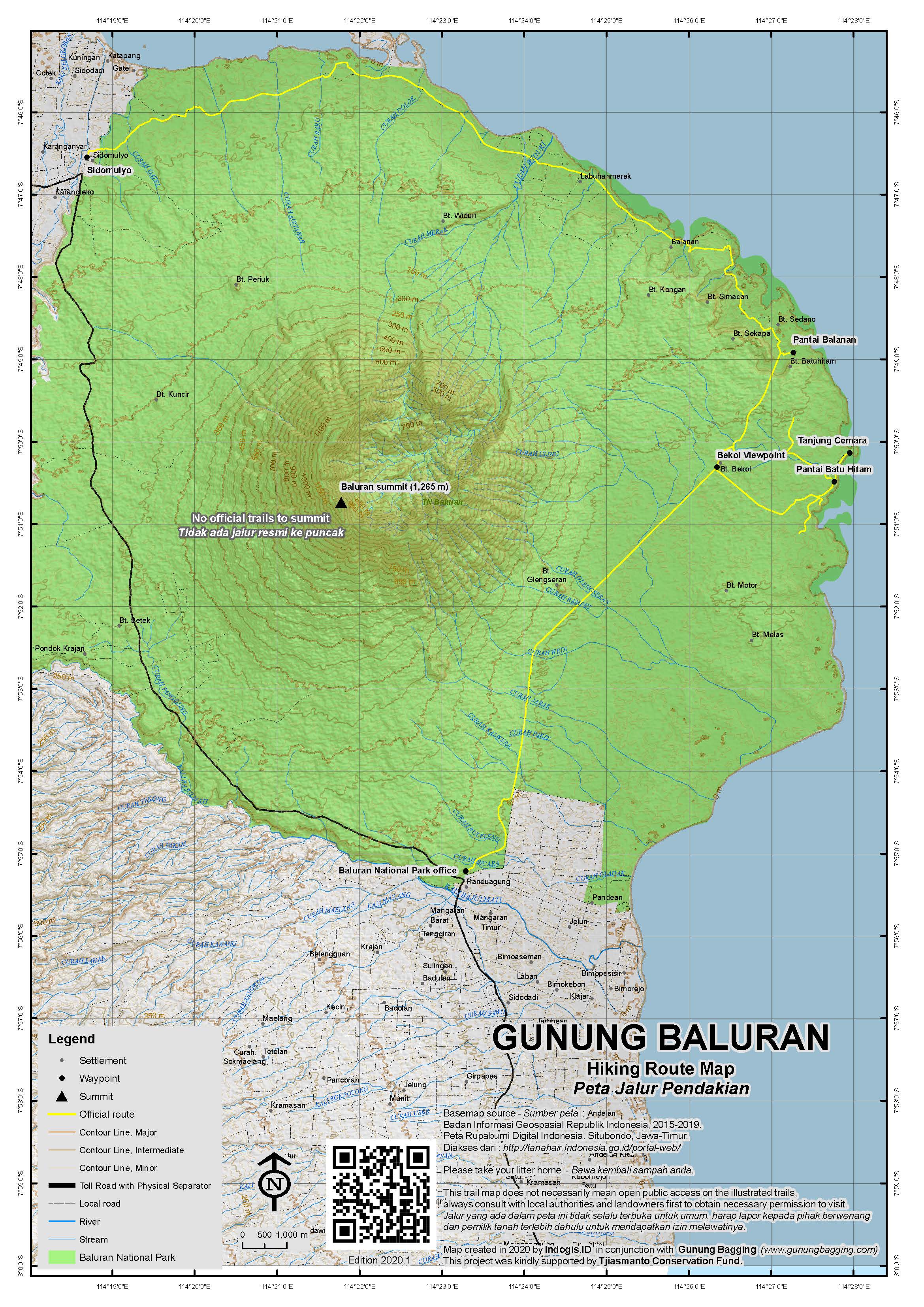
For a high quality PDF version of this and other trail maps, please download from our Trail Maps page.
Practicalities
- Getting there: For domestic flights from or to East Java, such as the airports in Surabaya, Malang and Banyuwangi, we recommend Baolau. Buses from Banyuwangi and Asembagus, or you could hire a car (expensive here).
- Guides and GPS Tracks: Want a PDF version for your phone? Looking for a guide? Need GPS tracks and waypoints? Gunung Baluran information pack can be downloaded here.
- Trip planning assistance: Would you like Gunung Bagging to personally help you in arranging your whole trip? Please contact us here.
- Permits: From the Baluran National Park office at Batangan at the entrance to the Park.
- Water sources: Assume no water on the mountain; take sufficient supplies with you.
- Accommodation: Try the Booking.com map above or use this link to search for suitable hotels, homestays, resorts and apartments for your trip.
- We recommend Safety Wing as travel insurance for overseas travellers and tourists hiking up to elevations not exceeding 4500 metres.
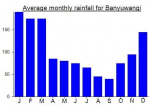
Local Average Monthly Rainfall (mm):
Location
Click on the blue arrow ![]() (top right) to see your current location on the map
(top right) to see your current location on the map
Origins and Meaning
(not clear). There might be two possibilities. (i) A nearby settlement was a place where balur fish were raised, or possibly belut fish (a kind of eel). With the addition of the suffix –an to balur or belut this comes to mean “a place where balur fish are raised”. The nearby mountain is referred to by the name of the settlement. (ii) Possibly balur is a variant of balut, an Old Javanese word meaning “veiled in mist, like a beautifully misty-eyed woman on the verge of tears”. (George Quinn, 2011)
Invaluable to read these reports as I am in Bali and looking over to the volcanoes. It’s very difficult to find salient information online so this is a treasure truth. Thanks so much for the whole project which I love. I worked on trying to create an accurate list of the top 100 peaks in Hong Kong. Such a challenge, with so much contradictory information, but really interesting thing to do.
Again, thanks so much for your website. Your contributions and thoughts are greatly appreciated.
Duncan Parry, U.K.
Hi Duncan.
I made a list of peaks in Hong Hong over a decade ago, but it was just named or notable peaks rather than based on a prominence threshold. Peakbagger has a list of P100s (100m topographic prominence) but I’m surprised to see there are only 10 entries. It may need expanding… https://www.peakbagger.com/list.aspx?lid=-932397&sort=eavg&u=m&hu=1&pt=avg&w=0
You could also try Andrew Kirmse’s site https://everymountainintheworld.com/ if your browser will handle it. However, the data may not have been individually hand-checked for Hong Kong with local topo maps.
You are welcome to send us a contribution towards the Gunung Bagging project, always useful. I am currently coordinating research to indentify prominent peaks across the Solar System.
Dan, Scotland
As of early August, Baluran National Park remains closed. I was hoping to at least drive to Bekol viewpoint but even that was impossible so we simply drove along the main road / highway through the park and took a few photos from there.
Quite why this Park remains closed but others nearby are open is a mystery. We went down to the entrance to Meru Betiri National Park (allegedly the last place a Javan Tiger was ever seen – some decades ago) at Rajegwesi (only 2.5hrs from Banyuwangi) and both the roads and scenery were far better than I had heard. Perhaps they have been resurfaced recently. This area is a turtle watching spot, but we were quite happy simply staying in a homestay and enjoying one of the best beach areas in Java.
Banyuwangi itself may not offer a huge amount, but it is so close to so many fabulous parks. From Meru Betiri we drove round to the equally incredible Alas Purwo National Park. Despite me paying 150,000 for entry and my Indonesian companion paying just 5,000, visiting Triangulasi beach was an absolute must. Roaring waves, hardly anyone else to be seen for miles. A part of Java that has barely changed in centuries.
Apparently Triangulasi comes from the area having a triangulation pillar presumably used for map-making, but it is not clear exactly where the pillar was or if it still stands. Certainly the Bakosurtanal map does not appear to mark it. There are a few ancient Hindu relics in the areas including temples that are still actively used to this day.
Another request to hike to the summit in August was rejected this week for the baffling reason that the summit is in the conservation area of the national park and there is no hiking. Birds can fly there, land-based beasts can wander up there should they so desire, but us naughty humans are prevented from visiting. Sometimes when you see the litter left by so called nature lovers on popular trails in Indonesia you do find yourself agreeing with the extreme conservation policies that keep all people (other than rangers or researchers) out of mountain areas. But with adequate respect and care there is no reason why conservation and ecotourism cannot be combined. The peak of Baluran would probably not be popular even if it was open to hikers (there are higher peaks nearby offering brilliant panoramas). For now, this remains at least as difficult as Raung Puncak Sejati – but for administrative reasons only. Let’s hope things change one day and humankind is not prevented from accessing these places by civil servants.
I emailed the National Park about this one again recently. Baluran may be the hardest peak to reach the top of in the whole of Java, simply because there is no interest in opening a trail to the summit, and without a trail, rangers do not want you wandering up there yourself. Perhaps the only way to get up there is to be part of a special scientific research group, though there are no reports of anyone having climbed it since 2009.
Comments from Nick Hughes regarding his recent hike within Baluran National Park…
“I joined a group of naturalists to the Baluran National Park in October 2012. I highly commend a visit to see its unique ecosystems, its wildlife and scenery. The Park, lying in the NE corner of Java, is largely within a rain shadow and hence extremely dry. A major challenge confronting the Park management is the African Thorn Bush (Acacia spp)that was introduced in the late 1990s as a fire control measure. This Bush is now overtaking the Park and crowding out feed for the Banteng (Bos Bali) and native deer, whose populations are declining.
Afterwards, I trekked into the ‘inside’ of the Baluran mountain starting at the Park centre, Bekol (42 m), which is 16 kms from the Park entrance at Batangan.
The Baluran crater is collapsed on the eastern side. I trekked up a dry river bed (dry season)to a point known as Kacip (450 m) where there is permanent spring water. Villagers from Karang Tekok, met along the track, were collecting kemiri nuts and wild honey. They indicated that one could keep trekking up the narrowing creek bed for some considerable distance although it was unclear whether the creek would eventually lead to a crater. I would advise caution if trekking up this creek bed in the wet season for fear of flash floods.
The inside walls of the mountain are extremely steep; assent of Puncak Aleng by this route would be extremely difficult if not impossible. The scenery along this trek is impressive – high, steep walls on each side as in the inside of a collapsed crater; dense vegetation; much birdlife. Villagers reported seeing yellow/black-spotted leopards (macan tutul).
I was accompanied by a Baluran Park guide who charged an exorbitant fee. Only Park guides are available within the Park. In fact, for this walk, a guide is hardly necessary. From the Park centre at Bekol, head west on a formed track; when reaching small hills, circumnavigate over the hills to the north and west till reaching a large, dry creek bed; then follow the creek bed into the ‘insides’ of the mountain. The Park rangers normally reach the creek bed by motorbike. About 3 kms from Bekol along the formed track, a motorbike track leads off to the right to avoid the small hills (above). Follow the motorbike track until reaching the creek bed. Alternative, simply hire a motorbike from Bekol. If walking carry plenty of water especially in the dry season.
Nick Hughes”