Facts
- Elevation: 2,181 m (7,156 ft)
- Prominence: 615 m
- Ribu category: Spesial
- Province: Peninsular Malaysia
- Malaysian state: on the border of Kelantan and Perak
- Range: Banjaran Titiwangsa / Main Range
- Google Earth: kml
- Rating:

 (1 votes) Add your rating
 Loading...
 - Other names: none.
Photos


Bagging It!
Gunung Yong Belar is the second-highest peak in the huge Titiwangsa mountain range and only a couple of metres below the very highest which is Gunung Korbu. It is a popular hike during weekends, usually with several groups hoping to complete a trek to one of Peninsular Malaysia’s highest peaks in a single day or two days and one night.
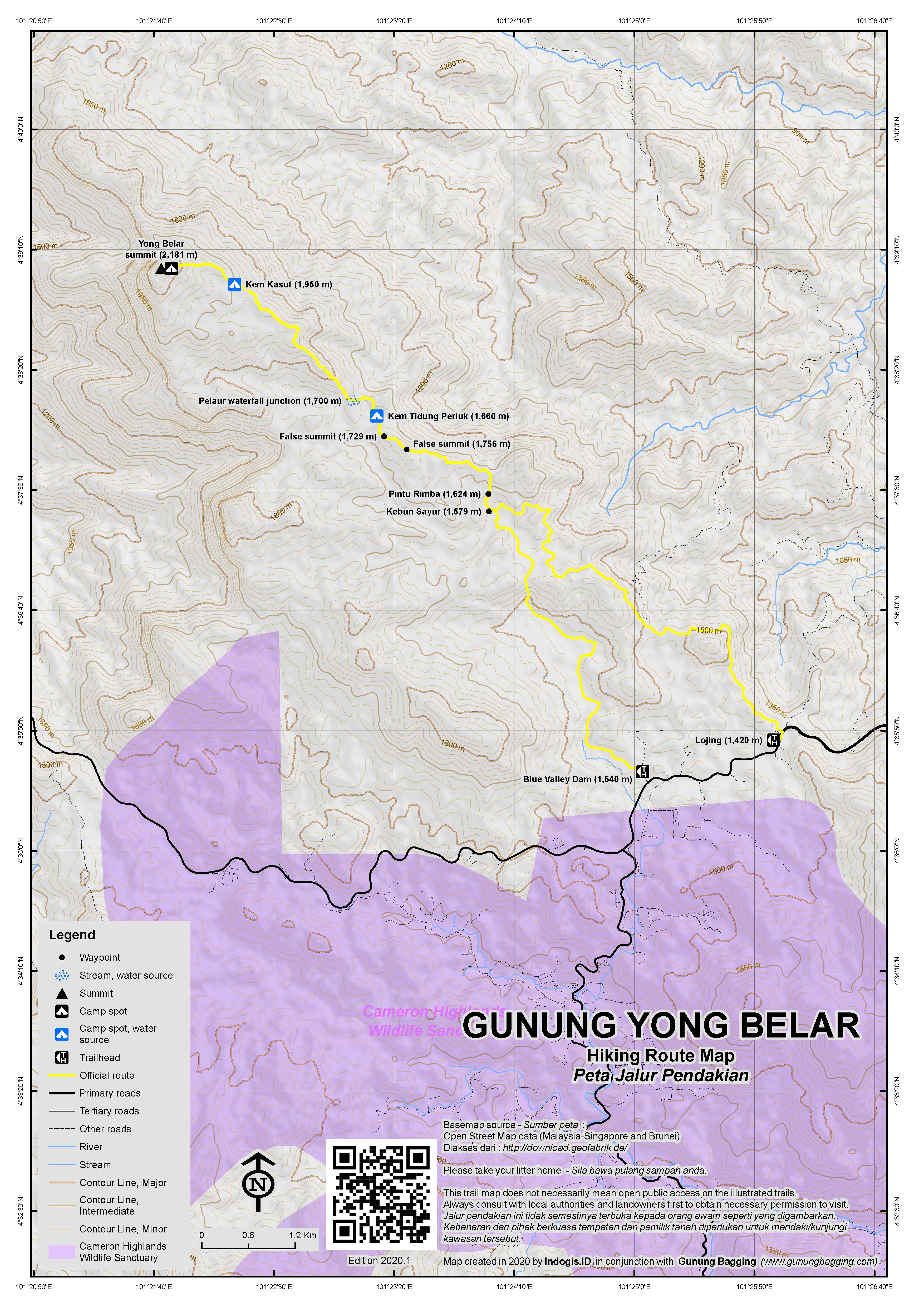
The starting point for the usual trek is in Lojing (1,420m) which is to the south-east of the peak and where there is a prominent mosque (Masjid Lojing) on the left side of the road (if heading up from Ipoh), along with public toilet facilities and ample parking for plenty of cars. Some hikers spend a few hours sleeping here in their cars before setting out on the trek at first light.
You can either follow the cement steps and black water pipes from Blue Valley Dam (1,540m) up to Pintu Rimba, or save an hour or so (each way) by arranging a 4WD to Kem Cabin at the end of a private vegetable farm which has a locked black metal gate at one point.
Most groups decide to take the 4WD several kilometres closer to the peak to Kem Cabin in the vegetable farm known as Kebun Sayur (1,579m, ‘vegetable plantation’) where cabbages, onions, potatoes and other vegetables are grown. This is not cheap at RM36 per person to simply sit or stand in the back, or presumably around ten times the amount if you want a vehicle to yourself. Luckily you can often join with another group doing the hike assuming you are heading up on a weekend. It certainly saves time when attempting the day hike.
You might think that only having to gain a little over 600 metres of elevation from the trailhead to the summit would make this an easy hike, especially in cool conditions up above 1,500m. However, this is a hike along an undulating ridge, with countless ups and downs and therefore total elevation gain is probably closer to 1,000m. It takes a similar amount of time to ‘descend’ again after reaching the peak. In this way it is rather like Gunung Semangkok, but at 9km one way a fair bit shorter in trail length!
Beyond the shacks where hikers are usually dropped off at the Kebun Sayur, the trail leads up a mini escarpment before entering forest (‘pintu rimba’, 1,624m). The first section of trail actually offers some pleasant views as it leads along a ridge with several ‘false summits’, notably at 1,756m (reached after just over one hour) and at another spot a further ten minutes along at 1,729m. You may be able to see Yong Yap, Bubu and Tok Nenek on the right of the trail.
After these false summits, the trail leads down to Kem Tidung Periuk (1,660m). Most hikers will have reached this point in under two hours. The ground is quit muddy and full of tree roots but this is one of the two main camping spots favoured by local hikers. One of the reasons for this is the stream on the trail just beyond the camp area itself. Take care descending to the stream – there is a thin rope to help on the steep, slippery rocks.
The next important point on the trail after Tidung Periuk is a junction (1,700m) where a left will take you to Pelaur Waterfall (‘Air Terjun Pelaur’). You may have heard the water from the false peaks. Continue right, dropping down a little way, crossing a minor stream, and continue heading on the main trail towards Yong Belar peak.
The trail now leads upwards and you feel you are making good progress. Once again, to the right of the trail there are one or two opportunities (including at around 1,855m) to look over northwards towards Yong Yap, Bubu and Tok Nenek, assuming the weather is fine. Look out for pitcher plants in this area.
The next campsite is Camp Kasut (1,950m) which is about 2 hours beyond Tidung Periuk (or 3.5 to 4 hours in total from Kebun Sayur). This is similar to Kem Tidung Periuk in that it is a little muddy and rooty meaning you definitely want a decent mat to sleep on. There is a basic water source nearby (approximately ten minutes) but you are advised to bring enough either with you or boil the stream water from Tidung Periuk.
The peak of Yong Belar is not far away, but the terrain gets increasingly challenging, with steep sections of mud and awkward tree roots and gnarled branches making progress rather slow. It takes most hikers about one more hour to reach the summit of Yong Belar, so about 5 or 6 hours up in total.
From the summit there is a fantastic view in good weather. You can see Gunung Korbu and its neighbouring top Gunung Gayong around 8 kilometres away to the northwest. Korbu is the highest peak in the Titiwangsa range, the second highest in Peninsular Malaysia, and just a couple of metres higher than Yong Belar. You can also see the shapely peak of Yong Yap in clear weather directly north. As usual, the earlier the better as far as getting a good view is concerned, and that is one reason that camping at one of the two camping areas can be a great idea if you have the time.
Just before the summit is a thin cement pillar marking state borders. This is where very tough hikers on multi-day expeditions known as Trans Titiwangsa drop down to the ridge connecting Yong Belar and Korbu and Gayong and ascend up the other side to what is known as Gunung Junction. Left here leads to Korbu and Gayong (this is Trans Titiwangsa Version 1). Right leads to Tok Nenek, Bubu and Yong Yap and to combine the whole lot is known as Version 2 and takes at least a week to cover most of the key peaks of the Titiwangsa range!
Back down should take no more than 5 hours, and hopefully you will not have to wait too long for your 4WD journey back to Lojing. Should you need to descend on foot without 4WD, it is probably better to head down to Blue Valley Dam (approximately 1 hour down) than follow the 4WD track (estimated over two hour walk down).
Bagging report by Dan Quinn (July 2019)
Trail Map
For a high quality PDF version of this and other trail maps, please download from our Trail Maps page.
Local Accommodation
Featured Guides
If you are a reliable local guide and would like to be featured on this page to increase your bookings, or a tourist who would like to support the development of a local guide business, please email danpquinn@gmail.com with the following information: Mountain name, guide name, guide location, guide contact details, and at least one English language review from a previous hiker who was pleased with the guiding services. An example is given below for reference. We have a maximum quota of 3 featured guides for each mountain page on the site. The fee for this is £20 (British pounds sterling, typically via the Wise app or PayPal) for a period of 1 year and helps to pay towards the ongoing development of the Gunung Bagging project.
- Name and location: Pak Budi, Surabaya, East Java.
- Contact details: +62812xxxxxxxx, budi@gmail.com, https://www.instagram.com/budi_mountain_guide/
- Review from previous client: “Budi was a brilliant guide for our September 2023 trek up Gunung X and I would definitely recommend him to other tourists“, John, USA.
Practicalities
- Getting there: Ipoh is the closest train station (about 1hr 15min away by car). Arrange 4WD from Guandi Miao temple or the mosque in Lojing to the trailhead (40 minutes) – in 2019 this costs RM36 per person (return) and each 4WD fits over 10 people in the back.
- Guides and GPS Tracks: Want a PDF version for your phone? Looking for a guide? Need GPS tracks and waypoints? Yong Belar information pack can be downloaded here.
- Trip planning assistance: Would you like Gunung Bagging to personally help you in arranging your whole trip? Please contact us here.
- Permits: Required in advance from Jabatan Perhutanan Negeri Pahang. Normally your guide will arrange this. You can register and pay for an e-Permit online from the Forestry Department of Malaysia website.
- Water sources: Available in stream just beyond Kem Tidung Periuk (1,660m). Also available near Kem Kasut (1,950m) but not as good quality.
Local Average Monthly Rainfall
Hi Sir
Do you have a hiking log from your GPS or smart watch ?
If yes, appreciate it as I’ll be revisiting it after 15 years from 18-19 Nov.
Yes I do.
See here: https://www.gunungbagging.com/downloads/yong-belar/
Enjoy your hike.
Just back from perhaps my best Peninsular Malaysia weekend yet. Packed quite a lot in. Started late on Friday night in KL as usual, met my excellent guide and together we drove up to Cameron Highlands, using the more northerly access road in (just south of Ipoh) rather than the narrower and often jammed route up further south. There was a police check not far from Ipoh, but they waved us on after hearing we were going hiking and seeing me still in my batik shirt from work.
Got about 30 minutes of precious sleep after this and suddenly woke up feeling unexpectedly cold. The windows were down and we were almost in Lojing, the usual starting point for Yong Belar, which is above 1,400m and therefore a little chilly at night. With a fair few rests at surprisingly busy service stations included, it must have taken us 4 hours to get here (just over 1 hour up from the expressway down near Ipoh).
In Lojing there is a very prominent mosque on the left of the main road with ample parking. Even before 4am on a Saturday morning this place was full of cars and there were quite a few hikers getting ready for the Yong Belar trek. I imagine it is pretty quiet during the week but on weekends this is a popular trail and we had no trouble finding two spaces in the back of one of the 4WDs.
After just 30mins of sleep it was pretty surreal to be hurting along a track in the dark at just after 4am. We were at the dropping off point by 4.45am and hiking by 5am. This first section of trail is one of the best for views – so it was a shame it was still too dark to admire the panorama. A few fast hikers overtook us, apparently planning on heading right over to Gayong and Korbu over the course of several days.
Thankfully the weather was nice when we arrived at the top just over 5 hours later. In total it took us about 5 hours of hiking plus 20 minutes or so rest time on the way. The summit was quite crowded with groups taking photos, and one hiker whose birthday it was was ceremonially covered in eggs and flour!
Having seen Korbu and Yong Yap, I now have to make plans to return for them – hopefully in 2020.
We were back down in about 4 and a half hours, plus 20 minutes rest time. I found the last hour or so after Tidung Periuk quite tough, with several ascents, keeping on thinking that this must be the last ‘up’ of the hike! Semangkok is supposedly much worse!
Alas, the 4WDs were not waiting for us (they are apparently quite regularly late) so we just sat and watched as various groups arrived to join us. There must have been over 30 hikers in all, as 2 4WDs were not sufficient to take us all back when they did arrive. Because the farm is private the drivers have a monopoly, at least for getting you past the black gate which is locked at most times. Some other drivers in the area might get you to the black gate, but you still have over 30 minutes of walking to the forest entrance. The farm workers appear to be Bangladeshi – they said nothing, presumably accustomed by now to having hikers sitting around waiting for their ride back to the main road.
One question remains about Yong Belar (and Yong Yap)…. What does ‘Yong’ mean?
After getting changed, we drove down to Ipoh for the night. Surprised to see a restaurant opposite our hotel called Restaurant Pusing Public. Pusing means ‘headache/ nausea’ so a translation might be Public Headache Restaurant! Whether this humour is intentional or ‘Pusing’ has another meaning in Chinese I have no idea.
The next morning after having spotted Tambun Cave prehistoric cave art on Google Maps, we went and had a look (via a quick glimpse of the impressive Ipoh train station building). Well, I am amazed that Tambun Cave is not much more famous as the art on it is quite fabulous. 3000 years old apparently, and featuring tapir, human, babi hutan, dugong and various cattle. There is even one drawing that looks like an orangutan, but they never lived in West Malaysia so it is either a sign of the strong cultural links with Sumatra or else a depiction of a human dancing with arms raised. To get there, it is very easy, near a fuel station just a short distance from the expressway. You need to ask permission from the guard, then wander across a sports field and up some overgrown and neglected steps, to the side of a cliffs with huge stalactites hanging down. One of the highlights of the weekend and if I only had a week in West Malaysia, this would be on my list of places to visit. Free of charge.
Then we drove back to KL and took a wander up Klang Gates Quartz Ridge AKA Bukit Tabur. This is on the edge of KL, and is apparently the longest quartz ridge in the world. What a stunning ridge it is, with various peaks from west to east and fabulous views on one side to Kuala Lumpur city, and on the other to Klang Gates Dam and forested peaks, probably including Gunung Nuang in clear weather.
Tabur is also very tricky, requiring lots of scrambling and a lot of faith in old ropes left by previous hikers. There are regular fatalities here, and the authorities have been reducing access and making it harder for those without local knowledge to find the starting points and get the RM5 permit you are supposed to obtain beforehand. The West peak used to be popular for sunrise tours but is currently closed. I hope they are working on making it safer with double ropes and so on, but perhaps it is simply going to be out of bounds permanently to stop people from having accidents.
We went up Tabur East, which is lower and a shorter trail but still demanding. Indeed, we didn’t reach the highest point because I simply didn’t trust the one worn rope that you needed to trust on the start of the last section. I had work the next morning, and a fall here would mean hospitalization or death. I’d do it if there were two ropes to ‘have faith’ in plus perhaps a helmet, but as it is it is pretty dangerous stuff. But it was a lovely way to finish the weekend with views over the city and the dam.
The information about elevation of Bukit Tabur found on summit signs and online is not of a high quality. Based on my GPS reading, East look to be about 350m from the highest point we got to (the second highest of Tabur East at 316m reading). The best sources seem to be Ramon Fadli’s site with his GPS readings plus some tracks from Wikiloc.
My best estimates are as follows, for the main 4 peaks from west to east:
Tabur West 450 (Wikiloc tracks).
Tabur East 359m (Ramon Fadli).
Tabur Far East 351m (Wikiloc tracks).
Tabur Extreme 538.9m (Ramon Fadli).
Would be keen to hear from anyone with the local topographic map for the ridge.