
Facts
- Elevation: 2,183 m (7,162 ft)
- Prominence: 1,993 m
- Ribu category:
 Tinggi Sedang
 - Region:
 Peninsular Malaysia
 - Malaysian state: Perak
- Range: Banjaran Titiwangsa / Main Range
- Coordinates: 4.6897, 101.2973
- Rating:


 (4 votes) Add your rating
 Loading...
 - Other names: The traditional name is Gunung Riam. ‘Korbu’ may come from ‘kerbau’ meaning water buffalo.
- World Ribus ID: 68508
Photos


Bagging It!
At 2,183m, Gunung Korbu is the highest peak in the Titiwangsa range and also the second highest peak in Peninsular Malaysia. It is part of the Tenasserim Hills chain (Banjaran Tanah Seri), a 1,700 kilometre-long granite ridge older than the Himalayas which runs all the way down from mid-Thailand to southern Peninsular Malaysia.
It was thought for some time that nearby Yong Belar (2,181m) might be the most prominent in the Titiwangsa range based on SRTM data but accurate topographic maps suggest that Korbu is indeed around two metres higher. This was recently confirmed by Malaysia’s Department of Survey and Mapping who state that both peaks were surveyed in 2012.
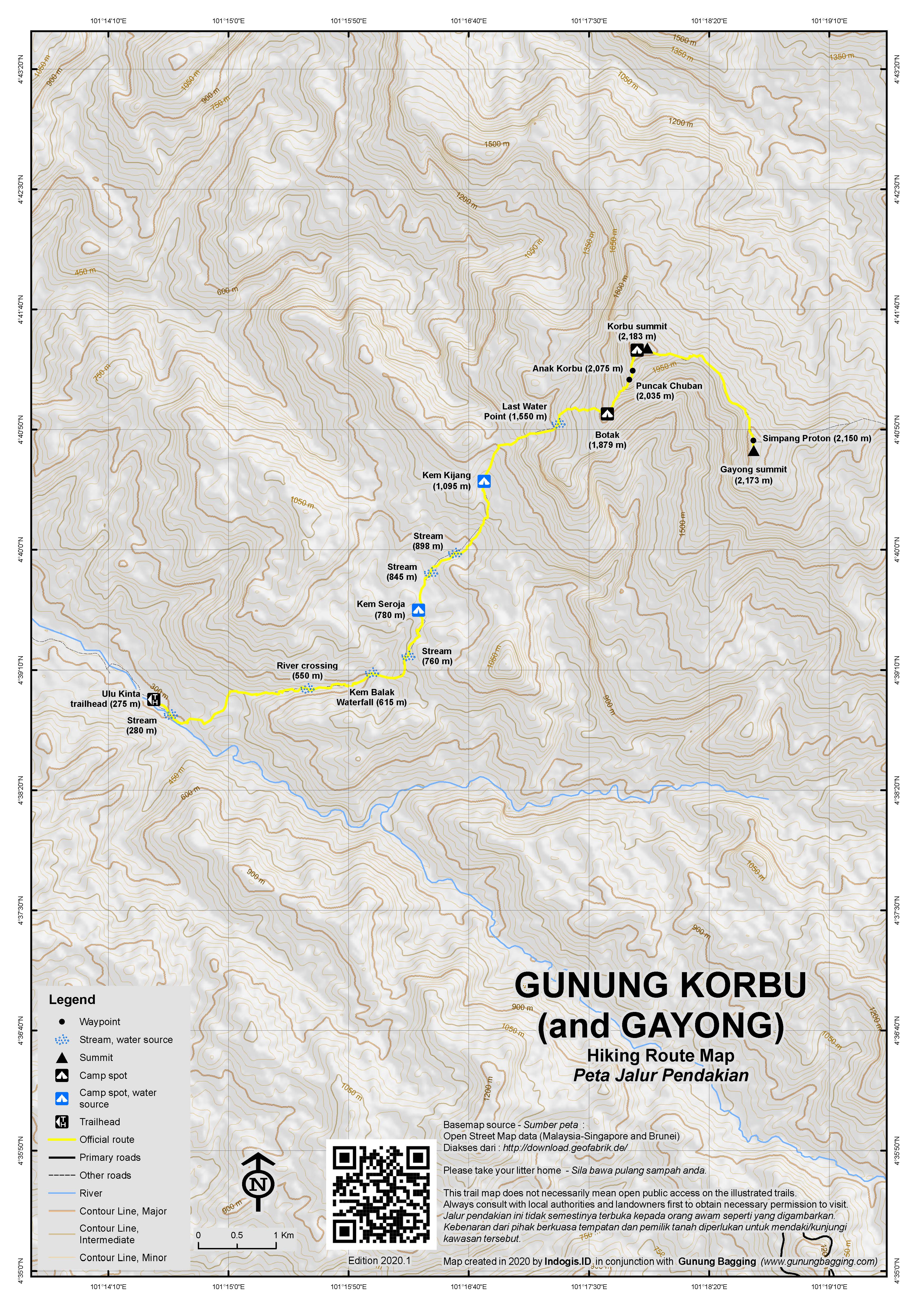
The trail starts at Ulu Kinta Dam (Empangan Sultan Azlan Shah) and the trail is around 15km in length. It is just about possible for very strong hikers to do Korbu over two very long days, but if you want to bag nearby Gunung Gayong (2,173m) too then you’ll probably need three days. Some Malaysian groups take 4 leisurely days, with an extra night camping higher up than Kem Seroja which is the most popular and largest camp spot.
Below is the typical itinerary for a 3 day hike, camping at Seroja both nights and therfore not needing to carry heavy camping equipment high up towards the peak.
Day 1 (1-2 hours of admin followed by 3-4 hours of hiking)
After the time-consuming process of sorting out the paperwork and then driving to the end of the private Ulu Kinta dam road (for which a second permit is required, also in advance), you can finally get started on the actual hike from the end of the road with just enough room for a handful of cars (291m). The trail gradient is rather gradual to begin with and there are numerous river crossings (including at 445m, 493m, 510m, 514m, and 562m) before reaching Kem Balak Waterfall (569m). This could be used as a camping area by a very small group, but in reality almost no groups camp here because it is between the start (or end) of the trek and not much further to reach Kem Seroja which is the finest and largest camp spot on the entire trail. It is, however, used by almost all hikers as a place to stop and take a break.
The waterfall is a very scenic spot with a mini beach of sand and a huge log stuck over the side of the waterfall presumably after being washed down from higher up in a major storm. Beyond the waterfall there are another couple of stream crossings (761m and 765m) before the spacious Kem Seroja (773m) is reached. There are sweat bees here, but also a lovely little river where you can bathe and get rid of the sweat! The temperature is exceedingly pleasant here. Make sure you get plenty of rest and sleep before starting an epic Day 2, probably not long after midnight!
Day 2 (13-18 hours of hiking)
Most groups start incredibly early, at 1am or 2am, and this is a good idea if you want to make it back before or shortly after dark. The first part of the onward trail is not easy to navigate in the dark, and there are many river and stream crossings (at 788m, 837m, 1,027m, 1,040m, and 1,053m) where the trail is not totally clear and you need to rely on your guide and a few fluorescent markers. After around 90 minutes to 2 hours you should have reached Kem Kijang (1,095m and easily missed unless you are seeking it out) after which the trail gets steeper and steeper including a ladder section (1,297m), Last Water Point (1,503m, with the water available at a stream just 1 minute down to the right of the trail), rock and rope sections (1,637m) and then Botak (1,829m), a small opening on the ridge which gives you your first decent view both of the surrounding hills and mountains and also the journey that lies ahead.
Botak is a good place for a break, and you should be up here around 4-5 hours after starting from Seroja. Korbu looks severe and improbably steep from here. Between Botak and Korbu summit, the trail is delightful with decent views, plenty of pitcher plants, and some seriously-challenging ladders and ropes to use to haul yourself up the face of Chuban (2,065m), then Anak Korbu (2,075m) before finally emerging through mossy forest at the summit of Korbu (2,183m), the highest spot in the entire Titiwangsa Range.
The top of Korbu has a few different flattish grassy areas suitable for camping on, but unless you are doing a longer traverse it is not recommended to have to carry your camping equipment all the way up here. The famous yellow summit sign is there, alongside some more temporary signs left by various hiking clubs. A reasonable view down to Ipoh is found just a few seconds away to the left, near where the obscure Senooi trail reaches the top from a different direction.
Korbu summit is a good place to take a break and wait for the rest of your group to catch up. It should have taken you around 6-7 hours to reach the summit from Seroja, and a descent would be a little quicker at 5-6 hours. However, most soldier on to bag another of Semenanjung Malaysia’s seven 7,000ft peaks, Gunung Gayong (2,173m). It’s around 4 hours, or 2 hours each way, to walk the 2.5km from Korbu to Gayong and back again, including dropping down to the col at around 1,980m. Despite the added time and likely exhaustion, it really is worth it, as the trail between the two peaks has some of the most beautiful mossy forest in all of Malaysia and in several places some truly excellent views, especially towards Yong Yap and Tok Nenek.
The summit of Gunung Gayong has a fair bit of space for camping too, and this is most likely used by groups doing a much longer multi-day traverse of the Titiwangsa range. Just prior to Gayong top is Simpang Proton (2,163m), an important junction for those either heading from or to Gunung Yong Belar. In total, it should have taken you around 8-9 hours to get to what is probably your furthest point for the day before turning back and starting the long return journey to Seroja.
The most important thing is to take rests when you feel tired, eat snacks, but no excessive breaks because otherwise you may have challenging and potentially dangerous sections to negotiate in the dark, such as the very steep part of the trail between Chuban and Botak. All being well, you can be back down at Seroja around sunset or shortly after dark. You will probably feel elated at having made it back in one piece!
Day 3 (2.5-3.5 hours of hiking)
This is simply Day 1 in reverse, but after a mammoth Day 2 you (and your feet) may not wish to start hiking early in the morning. Once back down at the trailhead you can congratulate yourself on having reached 2 of the 7 highest peaks in Peninsular Malaysia in a single trek.
For those wanting to spend 5 days or so exploring the Titiwangsa range, it could also be hiked along with Yong Belar in the following way: Trans Titiwangsa V1 camping trip (Blue Valley Dam or 4WD to Kebun Sayur – Kem Tudung Periuk – Kem Kasut – Yong Belar – Kem Kuali – Anak Yong Belar – Puncak H20 – Kem H20 – Gunung Junction – Kem Cerek – Gunung Gayong – Gunung Korbu – Chuban – Botak – Last Water Point – Kem Kijang – Kem Seroja – Waterfall – Empangan Sultan Azlan Shah).
Water source for V1: Kem Tudung Periuk / Kem Kasut / Kam Kuali / Kem H20 / Kem Cerek / Last Water Point / Kem Kijang / Kem Seroja
Bagging information by Dan Quinn (August 2023)
Trail Map
For a high quality PDF version of this and other trail maps, please download from our Trail Maps page.
Practicalities
- Getting there: For Malaysian domestic flights and flights within Southeast Asia, for example to Kuala Lumpur, we recommend Baolau. Tasek or Ipoh is the closest train station. In 2018, there is a northbound train leaving KL around 2330 and one returning south arriving KL again around 2000. Getting to the trailhead itself is a challenge with public transport so best discuss with your guide how best to arrange transportation.
- Guides and GPS Tracks: Want a PDF version for your phone? Looking for a guide? Need GPS tracks and waypoints? Gunung Korbu information pack can be downloaded here.
- Trip planning assistance: Would you like Gunung Bagging to personally help you in arranging your whole trip? Please contact us here.
- Permits: Two permits required – Dam permit and Forestry permit required usually at least 2 weeks before. Most local guides in Ipoh are familiar with the procedure. You can register and pay for an e-Permit online from the Forestry Department of Malaysia website. The dam gates are open from 6am to 7pm.
- Water sources: Available at Kem Seroja (773m) / Kem Kijang (1,095m) / Last Water Point (1,503m).
- We recommend Safety Wing as travel insurance for overseas travellers and tourists hiking up to elevations not exceeding 4500 metres.
Local Average Monthly Rainfall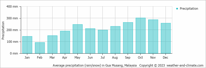
Location
Click on the blue arrow ![]() (top right) to see your current location on the map
(top right) to see your current location on the map
After 2 previous failed attempts due to… the covid pandemic and then all mountains in Perak being suddenly closed…. it really was a case of third time lucky for me and Korbu. I’d been exploring the mountains of Sabah just prior, and the trip back to Peninsular Malaysia from Sandakan to KL went pretty well, apart from my new hire car at KLIA having so little fuel in it that it almost didn’t make it to the nearest fuel station! Os that’s what i thought the problem was at the time! After filling up the tank I headed north up to Ipoh and the Art Cottage Hotel, which I had booked last time and had to cancel, and was keen on finally trying, being an arty sort of person! There wasn’t much in the way of art really but the location was spot on and parking right outside and just seconds away from a convenience store where I could purchase some cans of Guinness to guzzle.
I had some bad news about a hike the following week, Gunung Irau at Cameron Highlands, closed for a week at the height of the summer season. Another one I will have to hope the third time lucky rule works for too. But the Korbu and Gayong trek, the highest peaks of the Main Range, the Titiwangsa Mountains, was on, and starting the following morning. If I had one peak in Malaysia at this stage that I was most keen on hiking it was this.
We met the next morning (myself, Cik Fizi who is a local man with a very important job when it comes to mountain guides in Perak and a huge amount of knowledge and enthusiasm, and numerous other hikers from KL and elsewhere who would be coming on this trip, as it fell over a weekend, which is what other hikers are usually looking for). IPG is the best place to meet, the teachers’ college, as there are some simple shops and restaurants and it’s the last line of shops like this before heading in to do the paperwork and drive to the trailhead. I was still looking for gas for my stove and Efie Enterprise near IPG had some canisters so it was perfect.
At the forestry place, that you have to call off at and hand your ID in for the paperwork to be sorted out, you actually need to now fill in a form listing what is in your bag. A bit like Tahan but slightly less detailed. So be ready for that. It’s good that the authorities are reminding hikers not to leave any plastic or other waste behind, but it really does delay things and eat up half of your morning. Realistically over an hour for a large group.
Then we headed past the barrier to the Ulu Kinta dam (which also requires a permit sorting out well in advance, ideally 2 weeks) and drove to the end of the road, a small cul-de-sac with no sign that would identify this as the official trailhead. Enough parking space for perhaps 8 cars carefully parked but it would be easy to get stuck behind someone else who is still on their way down, and have to wait for a few hours there, so choose your positions wisely if you need to head off sharpish when you are finished!
And then you are into the jungle. Many river crossings, several very scenic, criss-crossing the river, then the waterfall area with a sandy beach perfect for a break. There was also a giant frog in the water there, sadly deceased or at the very least in a deep, deep sleep. I had initially considered camping up at Kijang on Day 1 and near the summit on Day 2, but as is the case with many of these peaks, it actually makes more sense due to weight and access to a nice stream or river if you have easy days mixed with extreme days rather than every day being 8 hours or so. And therefore this first day to Seroja was an easy day, 4 hours at a slow pace.
Seroja is large, near a lovely river for bathing in, but lots of sweat bees and leeches. And other hikers, not on a Friday night but when we got back down on Saturday night it was packed out.
Day 2 was a 2am departure, and this section is the hardest to navigate as it is criss-crossing a river and easy to miss where walking up a river turns into a trail on the left or right but there are some reflective smiley faces and tags. Mizi, helper with the guides, did really great on this and is a lovely man too. An expert on Korbu-Gayong and very passionate about it.
As might be expected, the trail gets steeper and steeper, and some of the group were really struggling here. 4 of us got to Botak, a vey small open area where you suddenly get a view of both hills in the distance and also the path ahead, by around 6.30am or so, just before the sunrise which was not that much of a sunrise due to all the low cloud around. But still very atmospheric. And tons of pitcher plants, beautiful red and white varieties.
Once the others had caught up we ploughed on, up the daunting-looking face of Chuban, where there are tons of ladders, ropes and section of mud. The most difficult bit of the whole trail, but you gain elevation quite quickly.
By 9am we were at the top, with a lot of breaks waiting for the others. Due to the vegetation up here, grassy areas good for camping if you like chilly conditions, it resembled an English garden somewhat. Over to the left, which is where the more obscure Senooi trail comes up from an alternative side, there is a viewpoint over Ipoh, the many little hills surrounding it, and to the Kledang range and Gunung Peninjau.
After a very long but not unpleasant wait, we embarked on the 4hr return hike to Gunung Gayong, another 7000ft summit with camp areas. Although not so prominent, the scenery is quite beautiful and there are some lovely views on the ridge towards Yong Yap and Tok Nenek especially. We met a team doing the V1, a long traverse of the Titiwangsa range, who were currently on Day 5 of their expedition and slowly heading down to Seroja with massive backpacks. This ridge isn’t half muddy though. Be ready for it!
After more photos at the top of Gunung Gayong, myself and one of the KL hikers decided to get started on the descent, as some were going so slow that we would be lucky to make it back before dark, and those ladders on Chuban are not the sort of thing to negotiate in darkness when you are exhausted. The two of us made it down by 8pm, so 1 hour of headtorch use, not bad, but still an 18 hour day. If we had not been waiting we probably could have done it in 13-14 hours. But the slowest of the group didn’t make it back to camp until 430am the next morning! A new world record!
One thing that was interesting was that Kem Kijang was not noticeable on ascent or descent. Easy to miss, as it seems the main trail doesn’t go through the camp but veers off just before it. Day 3 was an easy 4hrs back to car but really only 2 and a half. Sadly we didn’t start hiking til nearly 12noon due to the Seeker Hikers noodle munchers, some of whom were completely lacking in energy as some of them had never hiked a mountain before! Funny one to pick for your first hike. But it’s ok. It was very dry, no rain in 3 days so no major leech issues. I got to the car by 1430. 2 hours later the final from our group made it down safely and that was that. A challenging hike and one I won’t be forgetting soon. Korbu really does deserve to be the second-highest in the Malay Peninsula.
A Gunung Bagging trip to Gunung Korbu is likely to happen 21-23rd July 2023. If you are interested in joining please reply to this message ASAP or contact via the contact page. Thanks, Dan.
Hello Dan,
I just saw this page. I’d be interested in this objective but likely have to be August 15-17 ish time frame. Do you have flexibility? If not, I might have to get some logistics information from you, maybe via email. Two of us from North America are coming, with lots of experience (climbed some of the high peaks on earth) and energy. I’ll also like to talk to you about some other mouuntains as I’m doing research.
I plan to hike this in the coming week (Mar 1 – 7 2023) is anyone interested in joining me?
I will try for one day, starting very very early and running a bit of the downhill,
I wish I could but my Korbu trip will have to wait until later in the year. More importantly, do you have a guide? Have you sorted out permits? You can’t just turn up and hike alone. There is admin to deal with unfortunately. Also 1 day is probably unrealistic. But good luck anyway!
Trying to arrange a hike up Gunung Korbu in recent years has been a mammoth task. It is difficult anyway, given that 2 different permits are required – perhaps Malaysia will one day learn from the rest of the world (or even just Negeri Sembilan where ticket booths are the norm) that simpler ways of doing things are fine too.
We were booked to do Korbu in 2020 when covid hit so it was cancelled last minute. A good move or else we might have been stuck in Malaysia as international borders closed. And this time in 2022, we arranged the permits and hotel bookings only to have the authorities do a knee-jerk reaction of closing all forest areas in Perak, with no date of reopening. Perhaps they do not even consider the great inconvenience and cost that this creates for visitors, or what a bad impression it creates. My co-hikers will not be interested in booking a third time now – too much hassle, time wasted, with authorities prone to behave in unpredictable ways with no reasoning or warning. And what happens to payments made by guides for the permits when the authorities just remove access like this? I imagine the authorities do not give it even a second thought.
But I will make it there eventually. 2023 perhaps, assuming the Perak mountains are open once more by then.
Hi
I’m keen to do a Titiwangsa walk in 2023. I’ll be in Malaysia either around CNY, or around May, depending on how airfares from Melbourne work out. Do you know if there is much chance the park will be open, and any groups I might be able to join?
Hi Rodney. As it happens I may be doing Korbu myself in May. I will keep you posted.
As far as I know it is now open as normal (though closed for rainy season until end of February).
So…. another gunung trip to add to the huge and growing pile of cancellations due to coronavirus. How many more will there be across the world this year? And how are people going to retain any sense off sanity being stuck indoors, away from hills and beaches and so on?
Foreigners anywhere in the world at risk of being abused for ‘travelling’ and ridiculous scenarios at least in Indonesia of Regents (‘Little Sultans’) closing off certain areas to foreigners only, even ones who are resident in the country and should have every right to travel just as much as a local ‘born and bred pribumi or otherwise’. See the news story about surfers who had legally entered the country via Bali being turned away at ports in Sumba, running out of food and water and then our own story of being told the Regent of Tolitoli had signed a letter to keep out foreigners arriving whether by land, sea or air! Surely decisions like this can be made at a national immigration level unless the president allows it to be otherwise in the current climate, but that is not to say that these local ‘rules’ will not be acted upon. Sadly, many Indonesians aren’t nuanced enough in their thinking to understand that non-Indonesian citizens also call the country home – the number of times I get asked when I will be going back to the UK, just minutes after I have explained at length about my teaching job in Jakarta! I am sure they would be pretty offended were the same thing to happen to them if they lived and worked overseas, but perhaps thinking from other perspectives is rather hard for many of them.
Anyway, back to Malaysia. The day before flying in to KL from Jakarta (15th March), I was looking at the news, and our itinerary (Korbu, Tahan, Benum then off to Sabah for Magdalena), and being completely 50-50 about it. Who could give us a straight answer about borders closing in the forthcoming days or mountains being shut down by authorities? Nobody…. not even government ministers….total gamble based on whatever news you could find. The risks… obviously not a good idea to be flying, but a small group hiking in the forests is not likely to pose a significant threat of transmission (though it’s a great argument against these bloody horrendous groups of 20 or more making noise, litter and yes probably more likely spreading disease amongst themselves!)
Given the uncertainty over whether or not we would (a) be able to get back to Indonesia or (b) go hiking at all and some considerable concern about leaving relatives at home at a vital time to be keeping each other safe from transmission, I decided reluctantly to cancel. People were understanding but disappointed.
The next day (16th March), news came in firstly of Indonesia closing off mountains in Central Java, then from my workplace of staff being banned from leaving the Jakarta area, then of Taman Negara being closed down for at least 2 weeks (meaning Tahan would be impossible anyway) and finally late in the evening of Malaysia being shut down in terms of activities and tourism and entering and exiting from 18th March until at least 31st March. So…. it was the correct decision to cancel as we would have been stuck in Malaysia with no way out! Sometimes it pay to be cautious and listen to the sensible part of your brain, however much you want to bag Korbu, Tahan, Benum and Magdalena.
Success rate on Tahan and Magdalena for me is pretty bad – both 2 fails now due to not even starting the hikes! Third time lucky, but when will that be? 2020 is likely to be a very disappointing year for outdoor enthusiasts across the world. I am going to use this time at home to work on a self-employment plan I have to hopefully be able to have more flexibility from next year to hike more regularly and not just during one or two longer breaks from work which cannot be extended.
As for corona itself, based on what we currently know about its source, it is yet another great reason why becoming vegetarian is a noble cause. Leave the endangered species alone!
Hey great blog,
How do you get from Ipoh Train Station to trailhead? Public transport or taxis?!
I very much doubt there is any public transport all the way to the trailhead.
May I know how many days for the hike?
4 for noodle-eating groups at a leisurely pace, 3 for faster hikers, 2 for the ultra-fast or those not bothering with Gayong. Some folk have done it as a very long dayhike with no camping, but I imagine this requires running and starting and finishing in the dark.
I’m almost certainly going to hike this in March 2020. Please get in touch if you want to join….