
Facts
- Elevation: 3,339 m (10,955 ft)
- Prominence: 2,811 m
- Ribu category:
 Sangat Tinggi
 - Province:
 Jawa Timur (East Java)
 - Coordinates: -7.7654, 112.5902
- Rating:

 (41 votes) Add your rating
 Loading...
 - Other names: Arjuna, Arjuno-Welirang, Arjuna-Welirang
- Eruptions: Welirang 1950, 1952
- World Ribus ID: 69014
Photos


Bagging It!
This peak is the highest point of the enormous Arjuno-Welirang range, located just 50 kilometres south of Indonesia’s second largest city, Surabaya. The lower Welirang peak is active and still mined by local sulphur collectors. Arjuno (also spelled and pronounced ‘Arjuna’) itself is dormant and therefore perhaps a little less interesting than Welirang. The twin Kembar peaks nestle between them and a traverse of the entire range is one of the finest hikes in Java. It’s a huge area so camping for a night or two is absolutely necessary. If time is not an issue, then the best thing to do would be to visit both main peaks for dawn (i.e two nights on the mountains) but strong hikers could complete the range in two very long, strenuous days.
A guide is necessary for all routes (except Tretes to Welirang peak only, which is, for the most part, a wide stone track that jeeps sometimes use) as the navigating many of the paths can be very difficult indeed on the higher slopes because there are just so many of them and not many signs.
Unfortunately, finding good guides seems to be quite difficult for this mountain range and there have been several reports of guides with little knowledge of the range climbing totally unprepared. Therefore it is best to try to arrange guides in advance rather than just turning up at the starting point. The little permit office in Tretes is perhaps your best bet if you can’t arrange in advance but definitely need a guide.
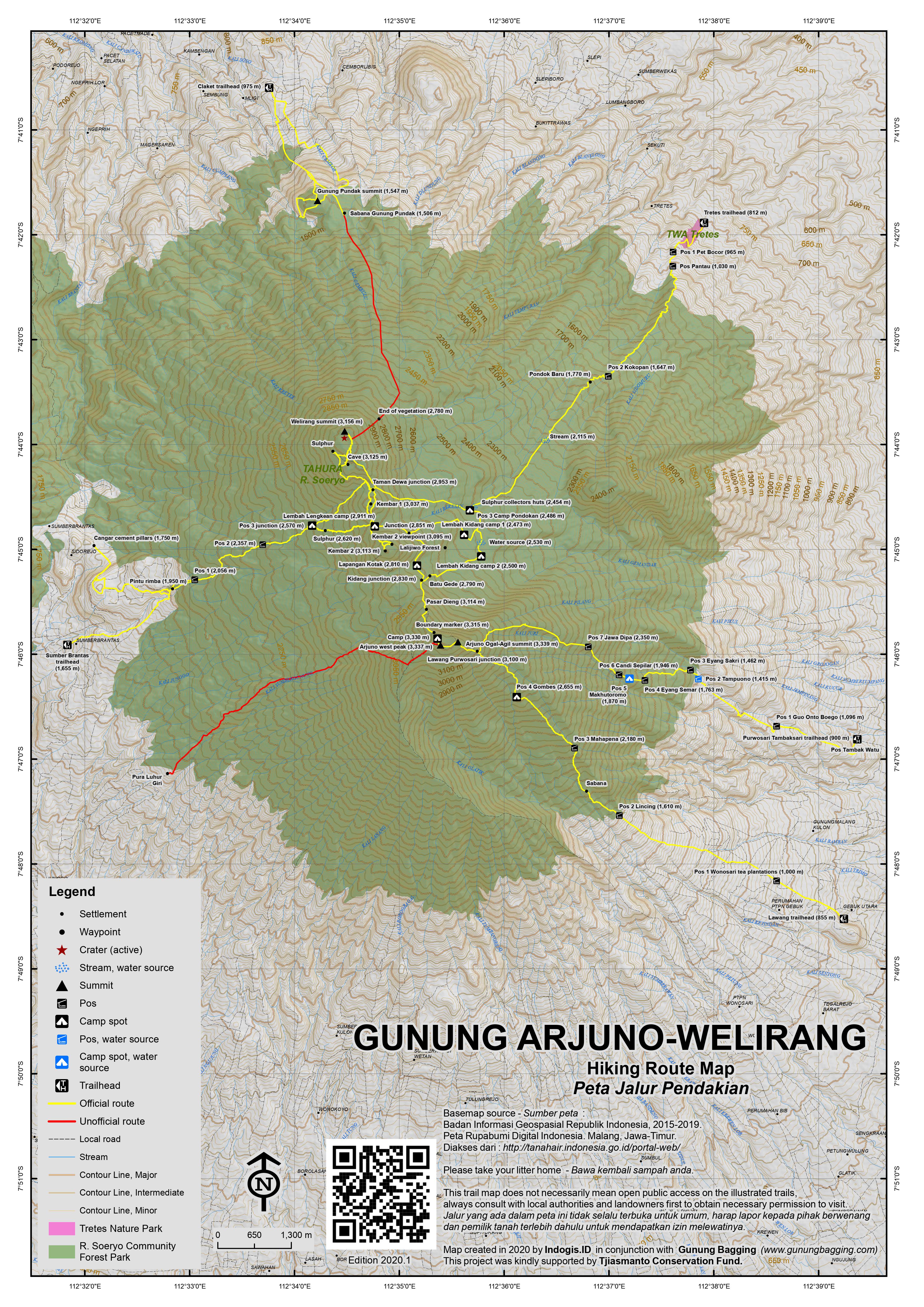
Tretes route
The most popular and well-defined trail starts from the mountain resort of Tretes (812m) to the north-east of the range. Be warned that although navigating this route is relatively easy, it is not particularly pleasant on your feet (especially when descending) and it is a substantial climb of over 2,400m in elevation gain.
This trail leads up a wide stone track through sparse pine woodland and an outlying peak, Gunung Ringgit (approx 2,477m high according to the basic map given to us at the Tretes office), is clearly visible on the left of the trail.
Notable landmarks after the office at the trailhead are Pos 1 Pet Bocor (965m), Pos Pantau (1,030m), Pos 2 Kokopan (1,647m), Pondok Baru (a hut with seats at 1,770m), a small stream (2,115m) to the sulphur collectors’ huts (2,454m, roughly 5 hours in total). After the huts, there is a popular camping area (Pos 3 – Pondokan – 2,486m).
Then it is either an immediate left (south) straight up towards Arjuno peak via Lembah Kidang or straight on (west) to Taman Dewa junction (2,953m) which is at the top of the mountain range pass just north of Kembar 1 and is the route to Welirang peak. However, depending on where you are camping, if at all, note that you can still reach Arjuno via Taman Dewa – it just takes longer than using the direct route via Lembah Kidang from Pondokan.
From Taman Dewa, turn left (south) to the Kembar peaks and on to the still-distant Arjuno peak or right (north) to the fascinating crater area of Welirang (3,156m, 3 hours to the highest point of the rim on the far side of the active Kawah Jero summit crater from the sulphur collectors’ huts).
Assuming you are continuing to Welirang, the very pleasant, near-flat track offers great views down the other side of the mountain (in the direction of Cangar and towards Gunung Anjasmoro and the unique shape of Boklorobubuh). Further along, a small trail leads off to the left. This is the sulphur collectors’ trail and you should be able to see them on a smokey side crater of the mountain, surrounded with sacks of large yellow rocks.
The trail to the summit of Welirang bends round a little to the right, passing an old, dormant crater full of vegetation on the left before leading across a rocky plateau where many local student hikers have written messages on the patches of flat volcanic sand using rocks. Finally you reach the summit crater – Kawah Jero – complete with an active sulphur fumarole. A circuit of the rim can be done fairly easily in about 30 minutes or so.
The highest two tops both offer incredible views of Penanggungan (the ‘little’ mountain that looks so big from Tretes!) and if you are lucky all of the peaks from Lawu in the west to Raung, hiding behind Argopuro in the east. In fine conditions at first light this is one of the finest viewpoints in the whole of Java.
It takes about 6 hours to return from Welirang summit to Tretes for those not continuing on to Arjuno. For those climbing from Welirang to Arjuno, you can ‘bag’ the two Kembar peaks en-route (the more northerly Kembar Satu – Kembar 1 – 3,037m and the more southerly Kembar Dua – Kembar 2 – 3,113m) but be warned this is the area which it is easiest to become lost in.
For those climbing Arjuno from Tretes (but missing out Welirang and just skirting the Kembars) then notable landmarks include Lalijiwo Plateau (Lembah Kijang) at 2,530m and with a water source and Batu Gede (2,790m). You generally need to spend at least one night camping in this area in order to bag Arjuno unless you start very early.
Sumber Brantas route
The Sumber Brantas/Cangar route is growing in popularity as at around 1,700m it’s by far the highest starting point. This route is especially useful for anyone wishing to quickly climb either Welirang or Arjuno as it starts so high up and leads to a pass between the Kembars. At the top of the pass, hikers can then choose to turn left (north) towards Welirang or right (south) towards Arjuno. Note that one road in the area ends as high as 1,800m beyond Pura Luhur Giri Arjuno – a Hindu temple – but this is not an official starting point.
Sumber Brantas is 11km beyond Selekta and the hike begins either at the official village trailhead (1,655m) or further on at two cement pillars (1,750m) just before the road begins to descend to Cangar air panas (hot springs at 1,628m). The start of the trek is a farm track leading through fields of carrots and potatoes.
There are plenty of track junctions so local knowledge is essential. At 1,950m the trail enters forest and leads via Pos 1 (2,056m), Pos 2 (2,357m) and Pos 3 (2,570m). Pos 2 – which is marked with a large boulder – makes a reasonable camp spot for anyone who has started late in the day, and the Kembars are clearly visible in good weather.
Pos 3 is actually a better camping area and it is here you can take a left towards Welirang or right towards Arjuno. Assuming you are heading to Arjuno, a little way beyond Pos 3 you will encounter some hot steam emerging from beneath boulders in the middle of the pine woodland (2,620m). The forest ends at 2,875m and the truly great views begin. Soon the trail reaches the top of the pass (2,911m) between the Kembars. This is an excellent and popular place to camp and is known as Lembah Lengkean.
The first peak to the south is Kembar Dua (Kembar 2 – the southern and slightly higher one at 3,113m) and from here you can enjoy the fantastic panorama to many other mountains both near and far. There are shallow, grassy craters and lots of sulphur vents on this peak so take care not to inhale the gases. From this peak, it is not easy to reach Arjuno directly as it is very steep and there are dangerous cliff areas. You need to skirt round the eastern foot of Kembar 2 in order to take the safest and most well-trodden route to Arjuno.
It’s a long haul up the slopes of Arjuno but the views are incredible – Gunung Butak to the right, Gunung Penanggungan to the left and Welirang behind (north). There are plenty of places to camp all over Arjuno mountain so finding a spot even at weekends should not be a problem here, especially above 3,100m.
The first top you will reach on Arjuno from this direction is crowned with a regional boundary marker (3,315m). The trail then descends slightly before heading up to a wider summit area. This ‘western summit’ is a very similar height to the final top a bit further along – which most people consider the true summit – and is probably even a metre or two higher.
From this top Semeru is visible right in front of you. The final top a little further east is a very narrow, impressive and boulder-strewn peak and there are the usual signs to inform you that you have reached the top of Arjuno (3,339m) although the previous top may well be the actual highest point. This narrow eastern peak is known as ‘Ogal Agil’ to local hikers.
Lawang and Purwosari routes
If not returning the same way, there are routes down to Lawang and Purwosari in the south-east. Both are long, long hikes which take a minimum of 6/7 hours. Just below the narrow summit with the sign is a trail heading east (in the direction of Semeru). It leads down through pine woodland to a tree with signs on it (3,100m). Here take a left for a route down to Purwosari (which eventually leads via some impressive ancient Hindu monuments) or a right turn for Lawang.
The Pursowari trail descends via Pos 7 Jawa Dipa (2,350m), Pos 6 Candi Sepilar (1,946m), Pos 5 Makhutoromo (1,870m), Pos 4 Eyang Semar (1,763m), Pos 3 Eyang Sakri (1,462m), Pos 2 Tampuono (1,415m) and Pos 1 Guo Onto Boego (1,096m) before finally reaching the trailhead at around 900m in Tambaksari. Pos 2 and 5 have water available and Pos 5 is the best spot for camping halfway up or down.
The Lawang trail is sometimes a little overgrown but if you keep the huge mountain range of Semeru infront of you it is difficult to get truly lost. Notable landmarks are Pos 4 Gombes (2,655m), Pos 3 Mahapena (2,180m) followed by a savannah area, Pos 2 Lincing (1,610m) which has an actual hut before the trail leads down through the large tea plantation (Pos 1, 1,000m) at Wonosari. You finally reach a road at 925m and the trailhead is at around 855m. Pos 4 is the best one for camping but water is difficult on this trail.
Ojeks can easily be arranged at the security post for the 4km journey to the main Surabaya-Malang road at Lawang. However, if you have time you can actually stay at Wisata Agro Wonosari – a popular weekend retreat at the tea plantation where there is a good range of accommodation available.
Claket route
There is also an infrequently used trail in from the north at Claket (975m). This leads via the popular Gunung Pundak (1,547m) and continues all the way to the northern rim of Welirang. Access remains unclear and latest reports are that this is pretty overgrown. A trail for experienced hikers that have already explored all the other routes, perhaps!
Bagging information by Daniel Quinn (updated May 2020)
Trail Map
For a high quality PDF version of this and other trail maps, please download from our Trail Maps page.
Practicalities
- Getting there: For domestic flights from or to East Java, such as the airports in Surabaya, Malang and Banyuwangi, we recommend Baolau. Lots of transport options from Surabaya and Malang – taxis, shared cars, buses, ojeks, angkots.
- Guides and GPS Tracks: Want a PDF version for your phone? Looking for a guide? Need GPS tracks and waypoints? Gunung Arjuno information pack can be downloaded here.
- Trip planning assistance: Would you like Gunung Bagging to personally help you in arranging your whole trip? Please contact us here.
- Permits: It used to be easy to arrange at the more popular starting points such as Tretes simply by taking a photocopy of your passport photo page or your ID card. In 2022, this has all changed, and not for the better. You must book online several days before your visit at the Tahura Raden Soerjo site where locals pay Rp11,000 but foreigners (regardless of if you live locally!) pay Rp200,000. At present, foreigners are not allowed in at all, due to Covid rules. The link between being a foreign citizen and spreading Covid is not clear but it creates a very poor impression of the local authorities who make such blatantly xenophobic rules.
- Water sources: Depends on the route but definitely wise not to rely on sources in what is a very large and wild area – take plenty of bottled water with you. The Tretes route up to the sulphur collectors’ huts has a couple of reliable year-round water sources detailed above as does Lembah Kidang. Pos 2 and Pos 5 on the Purwosari trail also have water sources.
- Accommodation: Try the Booking.com map above or use this link to search for suitable hotels, homestays, resorts and apartments for your trip.
- We recommend Safety Wing as travel insurance for overseas travellers and tourists hiking up to elevations not exceeding 4500 metres.
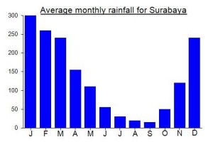
Local Average Monthly Rainfall (mm):
Location
Click on the blue arrow ![]() (top right) to see your current location on the map
(top right) to see your current location on the map
Origins and Meaning
Arjuno is the Javanese pronunciation of Arjuna. Arjuna is the middle (third) of the five Pandawa brothers who are heroes of the Indian Mahabharata epic and the plays of the wayang purwa, the classical Javanese shadow theatre. Arjuna is renowned as the handsome, invincible warrior of the shadow play, so perhaps the mountain is named “Arjuno” because it is as beautiful and impressive as the shadow theatre character. (George Quinn, 2011)
Gunung Welirang means ‘Sulphur Mountain’ – for obvious reasons.
The online registration site wasn’t working, and anyway I wasn’t a group of three, so I decided to show up at the Sumber Brantas office on spec and try the direct method. Turns out that on-the-spot registration is allowed for foreigners. I arrived too late in the morning so wasn’t allowed to get going immediately (and anyway there were no guides available that day) but instead stayed at the accommodation available at the office and set out the next day. Had a choice of doing a long day hike up and down or camping at the designated campsite and doing a pre-dawn summit. Took the two-day option. The group-of-three minimum is strictly enforced, so I had to take both a guide and a porter with me. At 1.25 juta per day for the two of them, that made it an expensive proposition. Plus Rp 480,000 registration for the two days (KTP Asing holders are not eligible for the local rate) and the bill came to Rp 3 million. At least I had some good hot food while on the mountain, though. Climbing with a few friends in order
to share costs is definitely the way to go. It seems most of the other high peaks in East Java are now following the miminum-of-three rule.
I paid Rp 40K for the health certificate at a small clinic opposite the Alfamart, about half a mile down the hill from the registration office.
The first part of the trek is now done in the back of a pick-up truck, which drops you at the entry point to the forest. The price is Rp 25K each way, and you need at least four people – or you simply pay the Rp 100K. It seems that the jeep is mandatory. Pos 1 used to be just after the forest entry but has been moved further up the slope. Camping is only allowed at the campground beyond Pos 3. I was climbing during a long weekend, so it was absolutely packed. It’s all a far cry from 1995, the last time I was there, when I hiked up Welirang solo without a permit, a guide, a health permit or an insurance fee, and camped on the crater rim. Happy to have bagged Arjuno at last, and the early-morning views from the summit ridge were fantastic. But I was shocked and slightly saddened by the level of bureaucracy that has now been imposed on Indonesia’s trekking community. The times they are a-changing….
Hi,
It’s a long shot that you will respond to this in time but I was wondering if you know if it is possible to find other solo climbers at the registration office to form a group of 3 with in order to avoid having to pay for a guide and porter especially if you are just wanting to summit Weliran? Or do you know if it is allowed to climb solo if you are only going to Welirang and not Arjuno? Thank you
Do you have any luck?
Attempted to summit Arjuno-Welirang on 26/6/24 via Tretes.
Do not attempt to climb without doing proper registration online first. A minimum group of three people is required for online registration, and it can fill up quickly for the weekends.
I knew prior that online registration was required. However that had technically been the case with Gunung Sindoro and one other mountain I’m forgetting the name of as well, but when I arrived at the base camp alone with no registration on these other mountains, it was no problem for me to go up. I figured it would be the same for Arjuno-Welirang so I tried my luck. Bad idea! They were very strict about the registration and since it was a Friday, it was already full. A health check certificate is also required to climb (I paid 20k rps at the hospital in Prigen). Some hikers told me I might not be able to climb but they would try to negotiate for me anyways, but I needed to get a health check first. I went through the trouble of going to the hospital that morning, paid for the health check and ojek, then came back to the warung that many hikers stop at located before the check post to attempt to enter with a group of 11 hikers who offered to adopt me into their group. I just want to say that Indonesians are so incredibly kind, I planned on a 2d1n trip but since the group I was trying to register with was going for 3d2n, they told me I’d have to stay with them. I panicked for a minute because I didn’t have enough food or water, but they assured me that they would give me food and water for the extra day. However unfortunately after 30 minutes of them negotiating with the park ranger, even offering 600k rps (!!!) for my entrance fee, they would not let me go (I believe I was told the price is usually 300k rps but don’t quote me on that). So I had to make the walk of shame back to my hotel, grab my things, and change my plans completely. Stupid mistake that could have saved me a lot of time and money. I hope that this prevents someone from making the same choices I did. It is a shame that they make it so difficult for foreigners to access these areas. I was told that they had just opened Arjuno-Welirang back up about a month ago after a long period of being closed due to volcanic activity. So perhaps this is why they were so uptight about the formalities.
Another silly but very important word of advice… In Tretes there are a couple streets (Jalan Foresta to be specific) that have a large density of “villa” accommodations. I made the mistake of thinking they were innocent homestays. Then the karaoke music started around 10pm and the entire street was loud with singing. Luckily I was able to fall asleep, but I was disappointed that the woman working didn’t tell me it was this kind of accommodation, despite knowing I was going trekking early the next morning. It gets worse… From the Indonesian hikers I met the next day, I learned that this street is notorious for prostitution. I knew something was weird when I woke up at 6am and heard people still singing… So yeah, avoid that street, even though it’s very conveniently located next to the trail head
Really sorry to hear about your unfortunate experience. its such a pity because it was never like that before. I checked up with some local climbers and the ultra trail runners to get a status update.
The pre-registration was introduced in Jan 2024. This is the website https://tahurarsoerjo.dishut.jatimprov.go.id/
Its all in bahasa and is a bit vague in some areas but currently it is supposed to be Rp200,000 per person per day. It does say min 3 persons which is something the locals felt shouldn’t be necessary and solo treks should be possible. I suppose that will depend on the attitude of the Pos staff and Tretes tends to be the least accommodating. There is a summary of their rules in the FAQ but they become more onerous when clicking on the booking link and getting into the details.
They say you should pay another Rp10,000 insurance at the Pos. They also say you are supposed to pay Rp150,000** for each camera!
The medical cert requirement is extremely vague: “Every climber, especially those climbing Mount Arjuno Welirang, must include a Health Certificate issued by a Hospital, Health Center, Practicing Doctor, Clinic issued a maximum of H-2 before climbing.”
I tried a booking to test the system. It appears to have a bit of a guide scam built in because it will not allow you to progress until you put at least 1 Indonesian into the group. It seems to suggest they want to keep your ID/passport at the Pos until you come down. I would certainly be uncomfortable with that.
** camera price suddenly jumps to Rp400,000 each camera for a foreigner in the booking page.
A tip from the locals but I have never tried is to go up from Cangar about 20km from Tretes.
Accommodation wise I avoid Tretes. It does have a bit of a dark history. I usually stay in Finna a bit further down in Prigen. They will drop you off and pick you up. I am Jakarta based these days but the GM there knows me and can put you in touch if you would like more info for this mountain.
Hello there !
I’m facing some troubles knowing if I’d be able to hike Welirang only without registrating or hiring a super expensive guide.
Can you just get up there and to the hike ?
Do you have any information about that ?
Not that easy to find reliable sources
Thanks in advance !
Not possible to do legally. They are both part of the same range which is protected and requires a permit for either or both.
https://en.tempo.co/read/1769692/hunters-blamed-for-4000-hectare-fire-in-mount-arjuna
Interesting that a recent GPS reading for the W summit (not the pointy E summit that signs proclaim as the the highest peak) suggested 5 metres higher. That fits in with Ryan’s comment below. So perhaps the true summit of Arjuno is not the shapely eastern top but the bulkier western top.
Hey Dan! A report back from a recent climb by Steven Song suggests that the east peak was 7-10 meters higher than where the true summit is marked out to the west. Would be very interesting with a proper survey.
Hello there. What a great website!
I’m planning to climb Welirang on August 2024, with a friend of mine. The registration website is asking for a minimum of 3 climbers in a group. Is there any way to bypass that rule and go only as 2 people? We will probably start from Tretes. We would rather not have a guide. Any advice?
You do not need a guide for Arjuna/Welirang. I have hiked it number of times and always solo. It’s very straight forward. From both main access points they will sell you a ticket to the park at the “gate”. Just don’t lose it as they may ask to show it when you leave.
From Tretes side the trail is very well defined. It’s quite a popular hike for students and can get quite busy some weekends (none of whom have guides! – same goes when they hold the ultra trail running events). The Lawang access point tends to be less busy but a bit more of a drive to the start.
Ryan Mazure’s post from 2019 is a good reflection of my own experiences. I just prefer the Lawang start up Arjuna for the sunrise over the distant Semeru but concur that Welirang is more interesting. There are some old temple ruins on Arjuna and I find its easier to descend towards Welirang than going up in the opposite direction but the crater and overall views around Welirang are superb.
As it’s August it can be pretty dry up there. The water sources near the sulphur miners’ huts can disappear completely. I recommend carrying plenty as no guarantee you can refill.
John – there are some important updates if you’re planning to climb now. See my reply to Madeline Hyrse’s post of 31 July 2024.
Overview:
Climbed Gn. Arjuna on 31-May-2022 via Sumber Brantas. Went up and down in about 12 hours (moderate fitness). Experience was excellent overall. The changes in landscape (tropical forest -> temperate forest -> savanna -> alpine), wildlife (deer, boar, birds) and of course views (Surabaya, Malang, Semeru, Aguporo, etc.) were all fantastic. The route description by the admin was very accurate as of the time of this review. Use of a guide is strongly recommended, due to many unmarked forks in the trail. The awful online registration system and the much higher-than normal expenses were notable annoyances in an otherwise positive (if exhausting) experience.
Stats:
Climb time: ~6.5hrs
Descend time: ~4.5hrs
Water used: 4.5L
Min temp: 16deg C
Guide used: Yes
Registration required: Sort of? (see description below)
Costs: 200rb (registration) + 600rb (guide) + 60rb (round trip ojek from ranger station to pos 1)
Online registration:
As of the time of writing, climbing Arjuna requires online registration, as described by the admin. However, it did not seem as if this policy was being actively policed- the ranger’s office asked for it, but there didn’t seem to be anyone checking the trailhead itself. In any event, the online registration system is terrible. More specifically:
— The online system requires a minimum group size of three climbers, with a designated group leader. The system does not allow for solo or paired climbers.
— The designated group leader must be WNI. WNA are not allowed to lead a group, for some reason.
— The online system shows climbing dates as available, but then subsequently rejects applications for those dates.
— WNI are charged 11rb for registration, while WNA are charge 200rb for registration. KITAS does not allow a WNA to pay the WNI price, which seems deeply unfair at best and will undoubtedly deter foreign visitors, hurting the recovery of the local economy post-Covid.
— The rules listed above (other than the absurd WNA registration fee) are by-passable when using a guide, which was provided for me by the rangers when I showed up at the ranger station with my rejection letter from the online system.
Guide:
My guide (Mas Bayu, WA +62 82141343653), was summoned by the rangers after I turned up at the ranger station alone with a rejection for my application to climb (invalid date, despite the date showing as valid in the registration system). Mas Bayu was very friendly and had excellent fitness. His English is limited, however, and the price of 600rb for 1 day was significantly above the ~300rb I paid for 1 day at Merbabu, Merapi, and Cereme in 2018-2020 and ~500rb paid for 2 days at Raung in 2022, so negotiation is recommended.
Well, having hiked most of the routes in years gone by I had hoped to visit the Tambaksari route, just to go up as far as Candi Sepilar (halfway up to Arjuno peak) and then have a look at the alleged meteor in Tambaksari village.
We stayed in Hotel Niagara, Lawang, a building that would have looked quite amazing 100 years ago when it was built but now feels out of place, surrounded by shabby concrete blocks and a busy road. The poor owners have also had to suffer from locals saying it is haunted, with absolutely zero evidence. Yes, it’s an old building, with large rooms and high ceilings. But the garbage that you can find online on social media that appeals to the ‘sinetron brains’ means that the hotel charge is ridiculously low. Show your support for rationality by staying here a night if you are in the area.
After being disappointed with having to cancel Panderman the day before due to it being closed to both Muslims and non-Muslims for all of Ramadan I was hoping for a better day. Sadly, the guide messaged to ask if I had booked online. No I hadn’t. I had no interest in going to the top, just to Candi Sepilar. Well, he said, you still need to book. I had a look and found the rules saying no foreigners are allowed to hike due to Covid, another logical faux-pas that Indonesia excels at. I asked and he said the rules had to be followed. You must book online, foreigners pay 20 times the price of locals, and are not even allowed up Arjuno-Welirang at present.
Delightful. Another trek cancelled due to bigotry.
We did have a nice stroll around Purwodadi Botanical Gardens though.
when i gone to arjuno-welirang mountain from sumber brantas route, nearby lapangan kotak lali jiwo jungle, we founded deers, monkey, birds, etc. conservation very important, taman hutan raya raden soeryo as company protect around arjuno-welirang-anjasmoro mountain must integrated safety our conservation from hunter and lumberjack.
I did Arjuno-Welirang as a superb day hike on June 10. My guide was the much-recommended Ladi (0823 3185 1343) from Sumber Brantas and he was really good and necessary since the way up from Sumber Brantas was quite overgrown and the way down from Arjuno to Pura Luhur Giri even worse. On the top, hiking is beautiful and relatively easy, we enjoyed great weather. Did not meet any hikers, but quite a lot sulphur miners.
Find more infos on timing here: https://de.wikiloc.com/routen-wandern/sumberbrantas-welirang-arjuno-pura-luhur-giri-50765264
We climbed from 09-11 August 2019.
There were reports of the area being closed due to fire, and we indeed saw many signs of scorched trees and blackened stumps. However, the office at the park gates still collected money for our permit of 72000 rupiah per person so i guess the route was still officially open!
Gojek from Surabaya to Tretes cost us around 250,000 rupiah for a 4-seater. Would recommend staying the night before/after at the very nice Surya Hotel & Cottages Prigen in Tretes which has the additional benefit of having the trail beginning right from the back door. Directly across the road from the hotel is a supermarket where you can purchase butane gas cartridges and other supplies like Indomee etc. Note that these are not the screw-on kind with lindal valves, you will need an adapter.
We carried approximately 12-15kg/person. Pace was accordingly moderate, with breaks in between. From Tretes to Kokopan (clean and plentiful water source) in about 2hr, and to Podokan (water was clean but low volume) in a further 3hrs, camping the night at Podokhan. Spots here for at least 10-15 tents around the sulphur collector huts.
IMMEDIATELY upon reaching Podokhan the trail turns left and proceeds quite flat towards Lembak Hijang which is supposed to be the last water source. We did not see any signs for water, although to be fair we did not do a thorough search. Proceed quite steeply up a loose slope that is badly eroded (Would not recommend this line in descent unless an experienced party) to reach a forested col with Arjuno on the left hand fork 1.5hrs away, and Kembar 2/ Kembar 1/ Weilirang on the right. The col would be a good spot to stash any heavy camping equipment since you will be passing back through towards Weilirang. We went to Arjuno summit and back, traversed around the side of the huge Kembar 2 (2hrs). Here you come to an open saddle with spots for several tents. Towards the left and leading downwards is the trail coming from Sumber Brantas, with Kembar 1 directly ahead (20min). Just after the summit of Kembar 1 is a nice campsite with space for 10-15 tents and sheltered somewhat from the wind. We camped here as it was getting late in the day.
Leaving our heavy gear at camp, we launched for the summit of Weilirang next morning (45min). There are several interesting camping spots around the crater – where we saw steam venting from the ground – might help make it less cold at night. There were also a number of monkeys living at the summit area, but they seemed peaceful and kept their distance.The sulphur fumaroles were absolutely breathtaking, and much better than the ones at Ijen (according to a teammate who has been there). Returning to camp, we then descended to Tretes in a bone-crushing 6hrs. Trekking poles are highly recommended for the section from Pondokhan and below.
Throughout the 3d2n, we met a total of about 3 teams of hikers. If your knees can take the descent, this is a mountain at least as scenic, if not more so, than nearby Semeru.
I just got back from climbing Arjuna and Welirang on 25th June. I left Surabaya at 430am and got to the gate at Tretes at 6am. All the Indonesian hikers were at the office waiting for them to open at 7.
I talked to Pak who was just opening his shop across from the office and told him I have to catch a flight the next day so I would pay when I got back. He let me park my scooter in the secure parking out the front of his shop right next to the office at Tretes.
About 1.5km after the parking there is a gate and office that says don’t continue without a permit. No one was there manning it so i just carried on. Note that there is no need for a guide up this mountain but you will get asked by everybody Sendirian?
I reached Pondokan at 10am and set up my tent. I rested for an hour before hiking to Arjuno. The day was amazing and no clouds. Very hot going up. I reached the summit after 2 hours of climbing. The way is well marked now with signs saying ‘puncak’ all the way and all split trails seems to join up or be short cuts. Just ask the sulfur collectors where the trail is to Arjuno, it’s not immediately clear but as you just come into Pondokan it’s on the left through a small grass track.
The middle summit is definitely higher because I flew my drone straight over the far pointy peak with all the flags 1m above my takeoff point and it cleared by a bit.
I found the summit not that interesting so if you have to choose one over the other definitely choose Welirang it is far more interesting and beautiful in my eyes.
Descent back to Pondokan took 90 mins and by this stage it was around 330pm.
As it’s dark at 530pm here I went to bed as soon as it was dark and awoke at 3am for the climb to Welirang. Around 2am I heard lots of people milling around so I thought they made an early start.
I walked the whole trail and didn’t see anyone. I reached the summit at 5am, around 2 hours walking. No one was around and all the people I heard must have gone to Arjuno.
I have to say this summit has to be one of the best I’ve climbed to yet in Indonesia. Sunrise was absolutely amazing!
I stayed on the top from 5am until 6 and then made my way back. I was down by 7 at the camp, packed and was down at the parking by 10am.
The hike down from Pondokan is absolutely soul crushing. The rocks are terrible and you wouldn’t wish that on anyone. I was lucky enough to even see 2 very old jeeps, each laden with 6 people (one riding on the bonnet) rattling their way up the mountain. It was quite the sight and I must say I’ve never seen anything like it.
I passed the ticket office and the guy inside just said hello and asked where I was from. So I didn’t have to pay for the entry.
I got to the motor bike old Pak stitched me up for the ticket. I thought oh no how much is it going to be. He sat me down and then gave me one ticket for entry to the forest 5k and one for parking 5k. Total 10k for entry and the great experience. He even wanted a selfie afterwards haha only in indonesia!
Totals
– Parking to Pondokan 10k – 4 hours
– Pondokan – Arjuno 5k – 2 hours
– Arjuno – Pondokan 5k – 1.5 hours
– Pondokan- Welirang 5k – 2 hours
– Welirang – Pondokan 5k – 1 hour
– Pondokan – Parking 10k 2.5 hours
There is camping spots on both mountains right near the summit. I saw frost on the grass just below Welirang summit so bring a warm sleeping bag. Pondokan is a good spot if you choose to climb both peaks but apart from that it’s really not that nice with lots of rubbish everywhere.
Hi,
Just hiked Welirang and Arjuno over 2D1N via Tretes last week on a recee trip. Beautiful hike, friendly locals and grateful for the good weather. Interesting mining community at Pondokan/Welirang.
This can be a weekend trip especially if you have transport and guide planned ahead. Of course, fitness level has to be there. Otherwise, it will make for a nice 3D2N hike as well.
Day 1
530am set off from Malang (was at Malang the night before after hiking Mt Semeru)
730am set off from Tretes
1230pm reach Pondokan
230pm set off for Welirang
430pm Welirang summit
600pm back to Pondokan, camp
Day 2
500am set off for Arjuno (decided to skip sunrise for more rest)
830am Arjuno summit
1130am back at Pondokan
1230pm start descend
430pm back at Tretes
700pm back at Surabaya
Hi iwt and thanks for the post. Could you please share the name and contact info for the guide you used? I’m thinking of doing the same program.
Thank you!
Matt
Hello everyone,
My name is Hamsah, if you need guide or porter for climb Arjuno and Welirang Mountain, you can contact me by email : dammasza@gmail.com or whatsapp :+6282234561872..
Thanks
Weekend bagging report from Jonathan W just received……
” We had a wonderful climb up Arjuna this weekend. The weather was dry and clear with stunning views on all sides.
We used a local guide, Ladi (tel 082331851343) who’s based in Cangar. He is incredibly experienced and knows all of the local mountains and different routes on each of them. He can also sort out porters (300rb per day) and equipment if you need to rent tents (40rb per day), sleeping bags (10rb pd), cooking equipment etc. Unfortunately he doesn’t speak much English, so you’d need some basic Bahasa to communicate.
We had 7 hikers, 3 porters and Ladi guiding. We climbed up using the Sumber Brantas route and, because we thought we might be short of time, had a truck take us up the farming roads all the way to the trail head which saved a few km and gave us about an extra 200 meters elevation from the cement pillars. We didn’t push ourselves hard and the hike took about seven hours to the summit.
An alternative route suggested by Ladi, would be to leave from Pura Giri Arjuno (otherwise known as Junggo’s Temple), which is a more direct route to the summit and apparently takes only about four hours – making up and down in a day possible for those fit enough. This Hindu temple (1655m) is about three kilometers to the right off the main Batu/Cangar road in the village of Bumiaji. I haven’t seen this route mentioned before in other write-ups.
We had a wonderful sunset at the summit and camped in a spot just twenty minutes walk from the top. It was very cold up there – the winds were incredibly strong and we spent a very sleep-interruped night thinking that our tents might blow away! The morning however was beautiful with clear views of other gunungs including Liman, Lawu, Kelud, Semeru, Butak etc
We decided to descend to Tambak Watu at Purwosari and the hike was long, very dusty and steep. We wanted to take a look at the temples along this route but there was really only one sizeable one to speak of and, while I’m glad to have seen it, it was a very tiring, seven hour, trek down and there are shorter routes like the Lawang tea plantation available. “
Hello
My name is Putra, I am an arjuno mountain guide.
If you want to climb arjuno mountain and need guide and porter, you can contact me by email or whatsapp
E-mail: alganuansa@gmail.com
Whatsapp: +62 85854517887
thank you
Ascended Arjuno for a second time in August 2015 (see my March 2013 log below) to bring friends visiting Indonesia from the US. In retrospect we should have known better than to bring them on Arjuno during the 17 Agustus weekend, when many college students are climbing the mountain (as they should be), but because of time constraints Arjuno it was.
We went a bit earlier in the week so avoided a lot of the weekend crowds (the 17th was on a Monday this year), but the trails were VERY crowded (ie several hundreds of people) as we descended via Purwosari.
We completed an otherwise beautiful 3d/2n traverse from Tretes to Purwosari, with two nights at the beautiful Lalajiwo camp where you are sitting beneath the Arjuno summit. Awesome views looking up but also intimidating to be reminded that you will be climbing that in a few days!
I insisted on descending via Purwosari because of the opportunity to visit interesting and beautiful temples that dot the side of Gunung Arjuno facing the east. Beautiful views of Semeru all the way were also visible. Purwosari however is very steep and tough on the knees, plus on that particular weekend was packed with climbers and pilgrims coming up to the mountains. Too crowded but what can you do!
In brief, our schedule roughly:
Day 1
9am – begin from Tretes
3pm – arrive Lalajiwo base camp after slow and steady ascent at good speed with moderate breaks
set up camp at Lalajiwo, dinner on the open fire, relax
Day 2
7am – wake up, begin hike to Welirang summit
1030am – summit of Welirang
2pm – back at Lalajiwo camp, relax, early dinner and early to bed
Day 3
230am – wake up, pack up camp, begin ascent to Arjuno summit for traverse
6am – summit of Arjuno
630am – begin descent via Purwosari route
1pm – finish climb at Purwosari village, pick up by car
very informative. thank you
hello everyone, sorry late to reply your email for find guide at arjuno + welirang as me guide. so if email to me you can email me at sugiekowisata@gmail.com or sugisonga@gmail.com
because may email suge_eling if I go at remote area i cannot reach connection.
best regard to everyone
SUGI
Arjuno can be done in one tiring but awesome weekend via Tambak Watu route (without Welirang). I arrived in Surabaya friday night and Sunday 5pm was back in the airport already.
This is a convenient and picturesque trail with shelters and water sources in Pos1 to 5 and warung in Pos2. As a huge bonus you get to see the ancient ruins of temples along the way.
How about the stone stairs with warrior statues guarding the entrance to the temple in the pine forest? and when you approach they start appear one by one from the morning mist… very mystical place.
Spend the night in Java Dipa 2350m (no water there). After summit attack were rewarded with the awesome views of Malang and Welirang.
Both ways came in tiring 20km and aprx 19hrs. Exhausting, but rewarding – definitely my best hiking experience on Java so far.
On top of that had not met a SINGLE hiker over this weekend. All peak to ourselves! and this is in the peak season (July) weekend. Where everybody went? Semeru? 🙂
And Mas Sam speaks English (basic).
To Dan. Mas Sam is an excellent guide living in Batu, Malang. His numbers are 0888 033 220 95 and 0888 058 072 33. He knows very well the Junggo and Sumberbrantas approaches.
This was my actual experience:
Day 1: Start 8am from Tretes pos jaga at ~800m elevation. Turn left when trail hits road after ~15mins. Go straight up road.
Reach Pos 2 Kokopan 10.45am. Clean water source. Thinner, pine forest.
Reach Pos 3 Pondokhan 1.40pm. Bracing temps. Walk past sulphur workhuts through field of yellow flowers.
Reach beautiful meadow campsite 2.20pm at lembak hijang. Water from foothill stream to right.
Day 2: Depart 5am, reach ridge 6am. Start ridge walk 6.15am, reach Arjuno peak 3339m at 7.45am. A little rocky.
Reach saddle ridge 9am. Rest till 9.50am, reach rest stop between two kembars 10.50am. Skirt Kembar 1, reach Kembar 2 at 11.15am. Reach rest stop for Welirang 11.40am. Half hour walk from here to fumaroles of Welirang. Need a gas mask.
The first time I visited this rang,e back in 2010, I had real trouble finding anyone in Cangar / Sumber Brantas to guide me up both of the peaks. I ended up going with a couple of local boys who had never been to the peaks before – only the saddle between the Kembars. I thought that would be good enough. They grabbed some carrots from the farm fields and off we went – slowly, very very slowly. They had trouble finding the correct trail to the saddle and we ended up camping below the col which was a bit of a disappointment given the really high trailhead on this side (1750m). The following morning, we ascended for about another hour to the saddle. It was there that they asked me for more of my Beng Beng chocolate bars before saying they would have to go back to the village because they didn’t have enough food with them. Effectively they were abandoning me, or completely buggering up my plans.
So I shot off alone, in the early morning, with two backpacks. Clearly there wasn’t going to be enough time to visit both Welirang and Arjuno so I opted for the latter because of its height and Ribu status.
By 4pm I was down in the tea plantations at Wonosari, utterly shattered! Fabulous hike though, despite being abandoned. I later got a phone call from the ‘guides’ saying they would report me to the tourist police if i didn’t pay them 500,000 rupiah! Ridiculous but because of the nature of the legal system and law enforcement in Indonesia (especially when it comes to ‘rich’ foreigners) I ended up sending them 200,000 rupiah for eating my chocolate bars and then abandoning me.
This visit this weekend from the Tretes side to Welirang was much much better (we didn’t take a guide). With petrol prices going up, chartering a vehicle from Surabaya airport to Tretes is a bit more expensive. About 250,000. The Tanjung Plaza Hotel just across from the trailhead was booked up for the weekend so I ended up at the basic but friendly New Srikaton – only Rp100,000 a night.
Myself and Jonathan had a couple of beers on the main street before setting off at 9pm on Saturday evening with torches. Apart from knowing the unmarked junction where you join the main track all the way up to the sulphur collectors’ huts it seemed pretty straightforward, and offering some great views over the silhouette of Penanggungan, the lights of Tretes, Sidoarjo and beyond. With it being ‘malam minggu’ there were quite a few others hikers camping out at various points. Water certainly isn’t much of a problem on this route.
We reached the sulphur huts (more like a small village) in just under 5 hours. It was freezing so we decided to continue slowly rather than rest. It did seem that it was warmer higher up the trail, so perhaps the sulphur collectors’ huts is a particularly cold spot.
Beyond the huts, you should see tiny fragments of sulphur on the ground which have been dropped by the collectors. This is a good sign that you are on the right trail, although we didn’t even spot the other trail across to Arjuno!
Once you reach the delightful, Edelweiss-covered col between the Kembars and Welirang you imagine it is a short, steep hike up to the summit. Infact, the trail skirts round the other side and is not very steep at all.
After a poor start to the ‘dry’ season we got lucky and had a fabulous panorama from about 5am to 7am. All major mountains from Lawu to Raung were visible. My general impression is that Welirang is an even better viewpoint and more photogenic (due to the fumarole and sulphur areas) than the higher Arjuno. But a travese of them both would be better still than doing them individually.
We didn’t have time for that this time so it was back down to Tretes in time for lunch at the Surya Hotel (amazing mashed potaotes – perhaps the best in Indonesia). All in all, we had climbed then descended 2,400 vertical metres and had been hiking with almost no pauses for 16 hours!
If you hike these mountains from the Tretes side, you will encounter signs referring to the mountain conservation area called Taman Hutan Raya R Soerjo. This area, which encompasses some, if not all, of the range, is presumably named after the famous Indonesian journalist… http://id.wikipedia.org/wiki/Tirto_Adhi_Soerjo
Just did 3d/2nt from Tretes (start 8am) -> Lembah Kidang (nice campsite day 1, reached 2.20pm walking moderate pace) -> Arjuno summit (left camp 5am, reached top 7.45am walking semi-fast) -> Kembar north -> Welirang fumaroles (noon) -> Pondokhan (sulfur campsite day 2, reached 2pm) -> scenic descent to Dayu Rejo, exit at Kaliandra resort (4hrs).
The sulfur gases near the top were too strong for me to want to summit Welirang, but otherwise the hike in all was beautifully diverse and not technically difficult. Was told best time to summit Welirang is morning when the fumes blow downslope, whilst by the afternoon they blow up and it’s better to observe the fumaroles from just below.
Lovely flowers throughout the trek, especially on the way down to Dayu Rejo. Brilliant red birds at Pondokhan in the morning. Dead black monkeys found bound on trail down to Dayu Rejo, probably hunted.
My local guide Mamad was completely off with his elevations (turned out Lembah Kidang is over 2300 masl, not 1500 as he thought, and saddle between Kembars was close to 3000, not 1800), and he inexplicably forgot to provide lunch on the first day, but otherwise he was knowledgeable with the trails. This was important as it sometimes became almost bush bashing, especially after turn off to Dayu Rejo not far down from Pondokhan (trail is marked by “Bukan jalur pendakian” sign).
I arranged the hike, a local guide and porter through Agus Sugianto (suge_eling@yahoo.co.id), who was responsive and helpful.
Thanks for the detailed rundown. This is very helpful.
Just completed a wonderful (and wet) climb of Arjuno via the Purwosari route. It took us two nights and three days to complete the hike. Unfortunately because of time and logistics constraints we could not complete a traverse down to Tretes. Also the guides explained that the Purwosari route is steeper and harder to navigate in the less than ideal weather conditions that we found ourselves in. The traverse will have to wait for another time!
In short, our route: begin at Tambak Watu village; continue onto four well marked posts of Onto Bogo; Tampuoono/Elang Sakri; Eang Semar; Makuto Romo; spent the night at Makuto Romo; departed early the next day via Candi Sepilar temple and the fifth post at Jawa Dipa; after that still another 5 hours to the summit. Be sure to hire a guide because of the many small routes circling the mountain, and also the less than well marked trail after reaching Jawa Dipa.
Benefits of Purwaro/Tambak Watu route were the chance to explore the fascinating Hindu temples of Candi Sepilar and Candi Wesi at the Makuto Romo (Pos 4) shelter where we spent the first and second nights. Definitely worth a visit if you are on that side of the mountain.
My guide was Tongki: 0857 469 87152
Hi… paul
i am tongki from malang east java.
i was your guide at arjuna mountain last year.
my phone contact is lost, and now my phone number is +62 82132683340.
If you need me to guide you again. please call that phone.
regards
Comment to Muh.Cahara Adhi S,
Regarding many tropical mountains in Java island already became a International tourist object I advised to you for come and arranging your trip on Ranger’s Office prior to action.On Ranger’s Office which it provided professional and educated personnels, they will be help you everything from registration, give more info included qualified guide and they coordinated with Basarnas ( Indonesia Search And Resque )for monitoring your trip. And for their jobs I think Ranger’s Office is very responsible.
And for your trip I tell you if now I also have plan to hikking and trekking in Indonesia ( as per my big bos ordered which he likes nature and archeology photos in the mountain areas )and maybe we will go to Semeru mountain for follow.
For preparation on my trip,everyday I always monitoring weather report, Semeru mountain condition etc prior to make a exactly schedule.
Don’t thinking the mountain in Java island and the meaning is safe area.Remember on the mountain areas which have a reserve area of mountain wildpark you not only can be seen wild deers and pigs, maybe you can met predators as like as a python or a tiger.
Safety is first so you come on the Ranger’s Office is the best option and they will be make to you a happy ending.
Regard
ONY TJAHJONO
Doha, State of Qatar
Mobile # : +974-66186275
E-Mail : ony.tjahjono@KEOIC.COM
Hello there please help me we want to climb arjuno via batu how actually we get there ? it’ll be good if i have someone to contact in batu. thanks
In pre-war years the pondok Lali Djiwo (altitude 2524 m) was very popular as a shelter in between the climb between Tretes and the one to the summit of the Arjuno. Does anyone have any information on this place? Does it still exist? It must be a little bit up from the sulphur collector´s camp, but more to the left (seen from Tretes). More information on Lali Djiwo (in Dutch), with lots of photo´s: http://javapost.nl/2012/11/16/lali-djiwo-vergeet-uw-ziel/
My Arjuno route ascended from Sumber Brantas and descended to Tawangargo village in the Karangploso district.
From Sumber Brantas it took 5 hours to reach the Kembars pass, 7 hours to the green sign at the start of the final hike up to Arjuno summit region and 9 hours total to the summit.
At the Kembars pass my guide Pak Sukamat, a Sumber Brantas villager, did not head up and over Kembar Selatan. Instead we followed the well-defined path that goes straight over the pass and begins to descend on the east side. This path leads around the north and east sides of Kembar Selatan, descending gradually from 2910m to 2790m. There are a few dry gorges and prickly plants but no serious obstacles and the path leads around to the grassy crater and boulder area on the south side of Kembar Selatan, as described by Dan. It continues directly along the left edge of the boulder area up to the green metal sign, which appeared to be facing in the wrong direction when I saw it.
According to my GPS, the east (Ogalagil) peak is higher by a metre- 3346m to 3345m- than the west (Jagalabilawa) peak.
Descending, our first plan was to go down to Junggo. For this route, the path begins between the main summit camping area and the west peak, heading down 100m to the right, toward a subsidiary pike and a long ridge stretching away toward the southeast. The pike itself offers good views to the west and has a cave for bad-weather camping, but the descent path passes to the left side of it toward the top of the long ridge. At the top of the ridge (3160m) is a fork, with the right path leading down steeply toward Junggo.
Smoke from forest fires burning on the Junggo route persuaded us instead to take the left fork, which follows the ridge down toward Singosari. This seems to be a long but pleasant path, with a fairly gentle gradient.
However, we opted to turn off to the right at about 2540m, where there is a metal “Puncak Arjuna” sign nailed to a tree, and follow a steeper path heading directly south. This path is good initially, passing through a grassy meadow studded with pine trees, but once it enters the forest at about 2060m it becomes steep, slippery and eroded, with intermittent patches of sharp-bladed elephant grass. After 5 hours total descent we reached a pine sap plantation and some houses at 1230m, a ten-minute ojek ride above the main road in Tawangargo. Although it is fairly direct, this Karangploso route cannot be recommended because of the poor condition of the trail in the forest section.
Whichever route you take, sun cream is vital for paleskins as long stretches of the trail and most of the campsite area are exposed to the sun.
Dear John
thanks for the great description, I feel this is the best route up. You mention a GPS, do you have a file you could send me in case we do not find a guide or the guide does not find your track? We want to go up next weekend…
My contact is werner_brandt@hotmail.com.
Comment to Ricky :
For going to Arjuna mountain, I have experiences and already tried 2 routes, the 1st from Tambak Watu and the 2nd from Tretes and I knew problems.Not as like at Semeru mountain which it has a lot of water on Sumber Mani the last base camp at Kalimati ( prior going to peak of Semeru mountain ).
In Arjuna and Welirang mountain area, the last area which you can to get a potable water and proper to drink on Pondok Welirang only.
And on pondok Welirang have a lot of water so you possible to cook, wash your body / clothes and fill in an enough water to your water storage on this area.
To prepare and bring an enough potable water prior to go to peak of Arjuna mountain I think is requirement.
When the last hikking and trekking to Arjuna mountain, we ( KEO team : 7 peoples ) have problem ( not enough water to drink and cook a food ) so only 4 peoples go to peak of Arjuna mountain.
Safety is first, I don’t want a risk on my KEO expedition and for make safe on trip, prepared all as per standard of hikking and treking is requirement for minimize a risk.
Oke, it is my info for your trip.
Regard,
ONY TJAHJONO
E-Mail : ony.tjahjono@KEOIC.COM
Mobile # +974-66186275
Will climb this mountain on 20 August 2012. We will starting from tretes and take 2-3 day’s there. Can anyone tell how to reach tretes from malang using public transportation ?
Ricky,
It is very easy go to Tretes from Malang city by public transport ( it has many options ).The route is by public transport from Malang to Pandaan and the last from Pandaan to Tretes.
When you already arrived at Tretes, you must to be registration on the Ranger’s Office at Tretes and you can asking everything about it and the Ranger’s Officer will be answered your question.Location Ranger’s Office is in the front side of Tanjung Plaza hotel at Tretes, it is very easy because every body already known it.What do you plan on your climb? For go to Welirang and Arjuna mountain, need minimum 3 days and 3 night and if you have 2 days only i think not enough.
It is possible maybe I also want to go to Welirang mountain only on interfal time 20 to 24 August 2012 after come from Doha-Qatar on 18 August 2012.I will go to Welirang mountain with my family and waiting an answered from 4×4 Vehicle Ride driver is have schedule or not going to Pondok Welirang from Tretes.Some kids are very interesting to hiking and climbing and for minimixe a risk by 4×4 Vehicle Ride is requirement.
And if you want to contact me please to see on the below.
Regard,
Ony Tjahjono
E-Mail : ony.tjahjono@keoic.com
Mobile # +974-66186275
Thanx for your info, it really help me. My plan is first day we will start hiking to reach pondokan and take a camp there. The the next morning, we’ll try reach the welirang summit, back to pondokan and continue to hike mt arjuna. We will take 2nd camp in pasar dieng, reach arjuno summit the next morning and go down.
Because its take one day to reach tretes from my home town, we will start hike at 22 August. i climb with my 2 friends, we are from central java.
email : ricky.overmind@gmail.com
Experience about Welirang and Arjuna mountain.
I am a Civil Engineer from Doha,State of Qatar.
On April 2012 I already gone to Welirang and Arjuna mountain from Tretes on my leave and as of on April 26, 2012 We ( KEO team ) were arrived on the peak of Arjuna mountain.
The mountains have a very nice aview, reserve areas of mountain wildlife park which wild deers and pigs can be seen and also good for hiking and trekking.
Regard,
Ony Tjahjono
E-Mail : ony.tjahjono@KEOIC.COM
route start from tretes:
http://www.navigasi.net/gofrm.php?c=FU&t=2580&page=last
Try this approach and you will fall in love. Start the hike from Junggo’s Hindu pura (temple). Ascent is straight and steep. After 7 – 8 hours you will get to the Arjuna Peak 1 or Penyancangan Jaran (Horse Station). If possible camp over there and make yourself astonished by the almost 360 degree views. Semeru and Bromo are visible. Then another 1 hour of steep trek to the real Arjuna Peaks. Jagalabilawa (Peak 2) and Ogalagil (Peak 3).
From Arjuna to Welirang is an easy 6 hours hike. Descent to the saddle between the 2 summits. Hike across the foot of Kembar 1 and try to feel the mystical atmosphere near the Kuburan Asu (Hounds Graveyard).
When you get to the Lapangan Kotak (Square Plain), turn right to Kembar 2 peak. Steep 1/2 hour trek, then descent to the sulfur miner’s “road” to/from Welirang. To the right is the trek to Tretes. Ascend a little further along the “road” then turn right. You will soon see the large cave with water drops from its ceiling. The cave is only a few meters deep and good to camp in. Freezing in the night. The famous sulfur mines and the summits are only 15 minutes away.
Descending, you could take the 4 hours trek to Sumberbrantas or the longer trek to Tretes. Tretes route is at least 7 hours and definitely only for them with steel knees and ankles. The trek is paved with loose soccer ball stones. Good for 4 WD jeeps but not for our knees and ankles.
Sumberbrantas offers you hot spring bath in nearby Cangar but transportation is scarce. Ojek is available. Tretes is a small town only 1 hour from Surabaya airport, then cars are many.
Some extra detailed info courtesy of Teddy and Juri…..
Tretes is connected by angkot to Pandaan (6000 Rp). Trailhead is at 900 masl (permit – 20 000 Rp per foreigner), there is an asphalt road to the right of the park office hut (ojeks go up for another 1-2 km) and a cobbled road to the left (shortcut). After passing another hut with a barrier (after 30 minutes), the road goes up through a forrest, inhabited by monkeys. 3 hours from trailhead is Pos 1 (1700 masl) with a shelter and flowing water. Another 3 hours up is the sulphur collector’s shelter (2450 masl – flowing water), where the sulphur bags are weighed and stored for collection by a very robust looking jeep once a day (seems a bit impossible, having seen the condition of the track). Here the paths diverge – left and up the slope for Arjuno and straight forward for Welirang. The left path leads to a perfect camping area after 20-30 minutes (flowing water). It starts gentle up the slopes (turn right when you reach the fork) and rises abrupt shortly before the ridge between Kembar 2 (south) and Arjuno. The path is very eroded and there are a lot of loose stones – a rockfall would bowl all the way down and could have grave consequences for the hikers behind and below you. There is a green sign, when reaching the ridge, where you turn left and continue, as described above. Total time from sulphur collector’s shelter up and down to Arjuno should be around 6-7 hours at a quick pace. The path to Welirang is well-defined and eroded by the frequent activity of the workers. There are actually several paths, that always join together and turn into a single track, when reaching the saddle between Kembar 1 (north) and Welirang (2 hours). There is only one junction after this point. Turning right (after 30 minutes) takes you to the peak and crater area, while the straight forward and bigger track leads to the fumaroles and sulphur clouds (~200 meters below puncak area). Total time up and down is not less than 4 hours. Spending 1 night in this mountain should be the minimum, as going either to Arjuno or Welirang on the same day, when starting from Tretes is a long hike. Same applies for returning down from the other peak. According to Junaedi (local guide, tel. 085855622874) it can take 12 hours, starting from the collector’s shelter, up to Arjuno, traversing the ridge (and the two Kembars) to Welirang and going down to the shelter again. But generally speaking, this mountain offers a huge diversity, the two peaks having totally different characters (alpine Arjuno and volcanic Welirang), so every day spent in there is well worth it.
What a great site! I’ve been living in or visiting Indonesia since 1979 but have bagged hardly any peaks – although Gng Merapi (in 1981) was one of them! Now, I just try to encourage others. Earlier this month my son and a friend climbed Mt. Arjuna, in East Java. I’ll ask them to do a trip report. For arranging trips up the mountain (best done as a 3-day hike) I can thoroughly recommend the Village Tourism Association in Tambak Sari, on the slopes of Arjuna. A good contact is Agus Sugiarto (Sugi), suge_eling@yahoo.co.id.