
Facts
- Elevation: 959 m (3,146 ft)
- Prominence: 743 m
- Peak category:
 Spesial
 - Province:
 Nusa Tenggara Timur
 - Island: Pantar
- Coordinates: -8.3076, 124.2884
- Rating:
 (Bagged it? Be the first to rate it)
 Loading...
 - Other names: ‘Woto Tuntuli’ on the Bakosurtanal map.
Photos


Bagging It!
This mountain is located on the north eastern corner of Pantar island. The is a village at the base of the mountain and a boat can be chartered from Alor Kecil. The Bakosurtanal map suggests the peak is as high as 995m. Desa Mawar seems to be the place to start and probably 2-3 hours to the top.
Practicalities
- Getting there: Just an hour’s boat ride from Alor Kecil to Bakalang. Alor Kecil is 30 minutes by ojek from Kalabahi and Desa Mawar at the foot of Tuntuli is about 20 minutes by ojek from Bakalang. Boat charters are Rp300,000 (one way) in 2021.
- Permits: Unknown. Probably not required.
- Water sources: Unknown. Assume none on the trail.
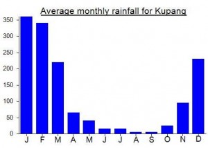
Local Average Monthly Rainfall (mm):
Location
Click on the blue arrow ![]() (top right) to see your current location on the map
(top right) to see your current location on the map
Had planned to hike Tuntuli a few days ago, with a contact in the village of Desa Mawar. Only 2-3 hours, he reckons, to the top, though whether it is the true top or not is unknown. It looks pretty steep higher up!
Anyway, the villagers were all fixing the water pipe on the planned hike day so it had to be cancelled and we didn’t have enough time to re-arrange. Next time for sure. Nearest losmen is in Bakalang – very simple indeed but only Rp50,000 per night per room.
There’s actually a village on the other side of the mountain – way up on the west – called Padangsul. Presumably not a bad place to start either. Could a traverse be done? Apparently so, but very far!
This mountain looks really good from the boat to Pura and from the actual trail up Pura. There appeared to be some kind of telecommunications mast up on the ridge behind the village at the foot of Tuntuli, so perhaps there is a trail at least in the right direction. As for whether or not there is a trail to the peak itself, that remains to be seen….