Facts
- Elevation: 2,417 m (7,930 ft)
- Prominence: 1,970 m
- Ribu category: Tinggi Sedang
- Province: Nusa Tenggara Timur
- Google Earth: kml
- Rating:
- Other names: Nuaf Nefomasi
Photos
Bagging It!
Gunung Mutis is the highest peak in the East Nusa Tenggara province. It is situated within a surprising alpine landscape and offers views from Timor Leste to the north to the clouds above Darwin to the south. The initial part of the trek is through rolling forest glade and open paddocks before climbing up to the peak itself. It is an easy hike and the landscape is very different to what is usually seen on Indonesian mountain trips.
The summit can be reached in 3–4 hours starting from the man-made lake (1766m) 8km beyond the village of Fatumnasi (1,527m) which is about an hour inland from Soe via Kapan. A guide is essential – not because the climb is particularly challenging, but because the trail is not clearly marked. It is best to begin as early in the morning as possible because the peak usually clouds over by mid-morning. Suncream is a good idea because although there is shade for much of the hike, certain sections are very exposed. Encounters with any other trampers are unlikely, though you may spy some locals while traversing the paddocks.
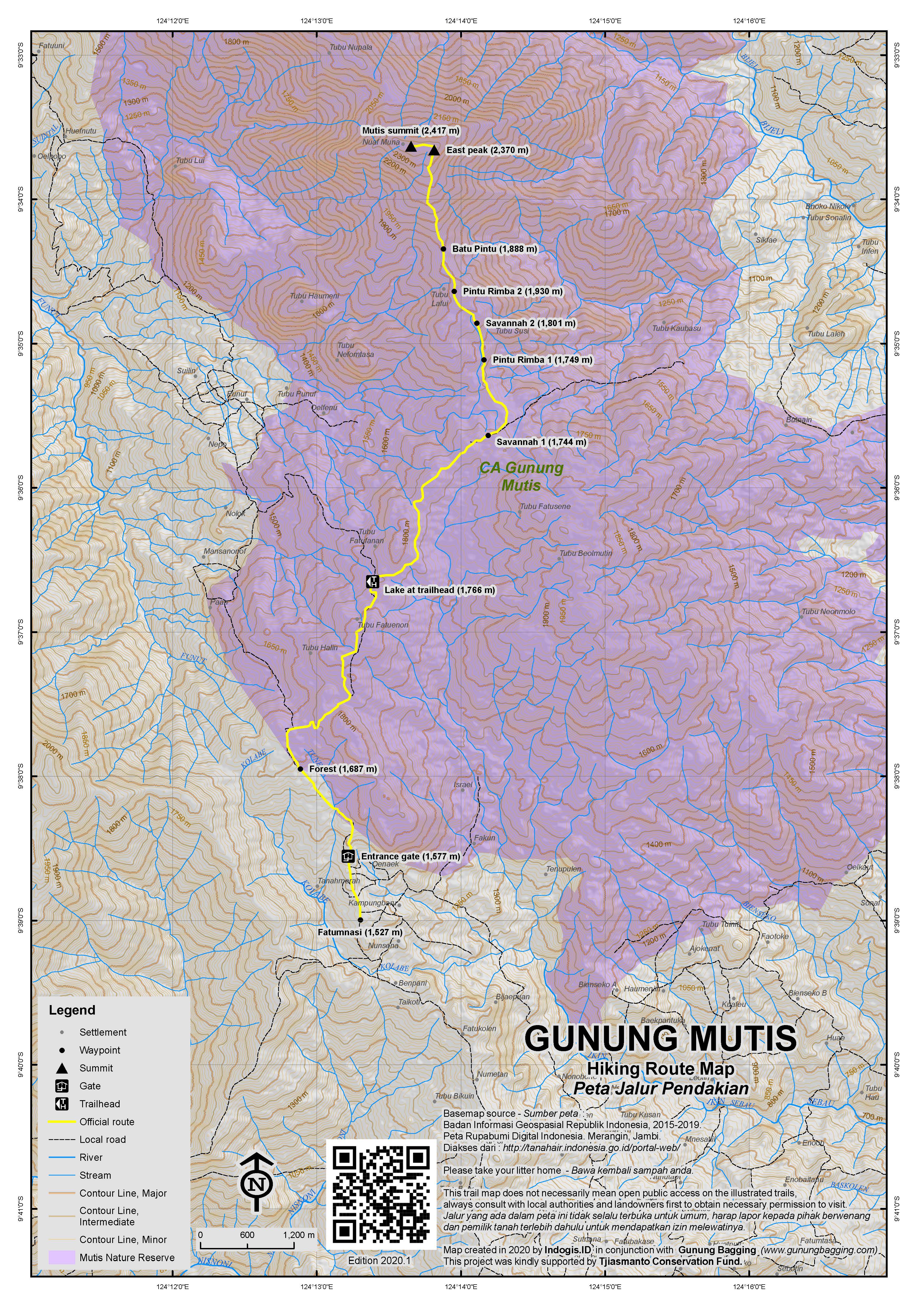
The trail initially leads along a rocky road passing entrance gates (1,577m) and entering a fairytale woodland landscape (1,687m) before reaching the lake at the trailhead (1,766m). It is normal to take motorbikes as far as this point.
The trail then leads through forest before opening out into a large hillside paddock (Savannah 1 – 1,744m), complete with cows and horses which are owned communally by the Fatumnasi villagers. The rolling hills are easily negotiated, with a small wetland being the only obstacle to the next batch of forest (Pintu Rimba 1 – 1,749m). A small path winds up and through the forest – more like the typical sub-tropical rainforest to be expected at this sort of altitude – and again opens up into another field (Savannah 2 – 1,801m).
At the top of this field you find yourself on a grassy ridge with excellent views in all directions. There are a few small cairns (piles of stones) which apparently mark the graves of some Dutch people who lived in this area many, many decades ago. Look out for the lovely pyramid peak of Fatu Timau which is on your left as you follow the top of the field in the direction of the tree-covered peak of Mutis itself.
Beyond this field is another forest entrance (Pintu Rimba 2 – 1,930m) before the Batu Pintu (1,888m), which is basically a large rock where a small offering is left to ensure a safe final ascent of the actual peak. It is revered by local people so please respect it. A typical offering might be some betel nuts, which are totally adored by people in this area so it is presumed that the spirit in charge of the boulder will like them too!
The final section is the most challenging part of the hike, as the path is reasonably steep and occasionally exposed to strong winds on the ridges. About an hour later you’ll reach the first high point (East peak at around 2,370m) and be afforded stunning views – provided the weather plays its part and you aren’t enveloped by clouds. You should be able to see the north coast of the island, back down towards the limestone cliffs and crags near the trailhead and eastwards over the valleys of central Timor towards the main border with East Timor. A five minute walk will take you to the true high point where a small monument and sign are situated.
The return route is the same as the ascent and before you know it you will be back in Pak Matheos’s traditional house, unable to refuse yet another large meal!
Bagging information by Pete Ryan and Merrin Rutherford. Updated by Daniel Quinn.
Trail Map

For a high quality PDF version of this and other trail maps, please download from our Trail Maps page.
Local Accommodation
Practicalities
- Getting there: Plenty of transport between Kupang and Soe – just ask at your hotel. Angkots can be taken from Soe to Fatumasi – timetables are irregular though so it would be a good idea to allow some time to get there. The road is not great in places, but surprisingly good in others, if you have hired your own car – however driving in the dark makes the drive more arduous. Follow the signs from Soe to Kapan and then to Fatumasi. An ojek from Soe to Fatumnasi costs about Rp50,000.
- Guides and GPS Tracks: Want a PDF version for your phone? Looking for a guide? Need GPS tracks and waypoints? Gunung Mutis information pack can be downloaded here.
- Trip planning assistance: Would you like Gunung Bagging to personally help you in arranging your whole trip? Please contact us here.
- Permits: Not required.
- Water sources: None on the hike. There are a couple of very small warungs in Fatumnasi but it is better to buy sufficient supplies in Soe or Kapan before you hike.
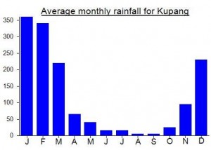
Local Average Monthly Rainfall (mm):

Location
Origins and Meaning
Mutis means ‘the flow of water’. (Gabriel Faimau, 2011)

 (9 votes) Add your rating
Just completed the very pleasant hike to the top of Mutis in perfect conditions – not a single cloud during the whole day, guaranteeing perfect views in all directions. Thank you for the excellent trail map Dan, it was very useful. The path between the lake (which is now more of a marsh) and the first savanna is no longer practicable for even the best 4-wheel drives though 4-wheel drive trucks with really high ground clearance might still get through very laboriously.
Also confirming the excellent experience with Pak Mateos Anin’s hospitality. He has recently built a few bungalows for the government about 100m further up and on the opposite side of the road. As can be expected, shoddy construction work, soulless and dusty setting with concrete dominating the land plot.
Anyone knows if it’s possible to rent a scooter in Kupang and drive to Futamnasi ?
I asume it would be best to spend one night in Fatumnasi, climb Mutis, spend a night again and go back ?
How safe it is to leave scooter near the enterence of the trail there ?
Anyone have an idea if it’s possible to do the same with Fatu Timau ?
A little bit disapoiting mountain for me. Did this as a two day trip from Fatumnasi by public transport.
Information regarding public transport is the same in 2015 as posted by John Hargreaves in 2012, just I had troubles finding bus station in Kupang (terminal Oebobo is where buses leave from).
From Lopo Mutis Homestay Ojek costs 100000rp per person both ways, up to the mountain and back to the homestay. But Ojek took me much further than I expected, like 3-4km further man-made lake. The hike was only 3.5km to the summit and took 1 hour 45 mins, descend 1 hour 30 mins. Did not use guide, but I had gps.
The reason the hike was disapoiting is that there are too many trees at the summit and the views were not that great. It was semi cloudly, but even in the good weather trees block the views. Since getting there by public transport takes alot of time and is quite inconvinient, the enjoyment for such a short hike with limited views does not reward the efforts getting there.
As a geologist I very interested to go there to see the outcrops of very old metamorphic rocks (Jurasic age, more than 200 million years.
Anyone can suggest what is the best month to go there? What can we contribute to the local students, yes ofcource books, atlas, what ells? Once again many thanks for the posting of Gunung Mutis with very beautiful pictures.
Best regards,
sugeng-Jakarta
Does anybody know why it is called MUTIS? Do you have any information? Thanks a lot.
I climbed Mutis in May 2012.
Timings were as follows. Taxi from Kupang airport to Oesapa bus stop, 10 minutes. Bus Oesapa-Soe, 2h30. Bemo Soe-Kapan, 45 mins. Ojek Kapan-Fatumnasi, 45 mins. (No bemos through to Fatumnasi.) Stay with Pak Mateos (now Rp100,000 including copious tucker).
Ojek Fatumnasi to start of hike at lake, 40 mins. Ascent 4h. Descent 3h. Ojek back to Fatumnasi, 40 mins.
The rainy season was still ongoing during my visit. The forest was damp and green and Steve and I had constant close cloud cover with intermittent drizzle. But even visibility of 200 meters is enough to see that this is a lovely area, with special people.
Hi Dan,
I have been to the peak of Gunung Mutis. Your pictures remain me about my climb. Next time you visit Kupang, you can contact me, may be we can have a beer and talk about Mount Mutis
I would be very happy to do that sir. But, alas, I now live in Hong Kong. I hope you try Fatu Timau sometime…
Hi Dan, do you have any contact details for Pak Matheos’s homestay – or for other guides in the area? I’m thinking of doing a quick trip to Timor Barat over 5 days for Lebaran . What do you think – enough time for a quick trip in and out of Kupang and a quick gunung bag?
Not sure if you remember but we met on the Java Lava trip to Pelabuhan Ratu earlier in the year. hope all is well with you. Cheers, Paul
Hi Paul. Look on the guides page for guides for this and Fatu Timau (under ‘resources’). Funnily enough, Andy is going to do these two next week so your trips may coincide – I sent an email to him….definitely enough time to do them.
Cheers and hope to see you on Wed 7th for a beer at Ya Udah, Menteng…
Hiked up Mutis for dawn yesterday. A truly fantastic mountain quite unlike any other in Indonesia. Pak Matheos’s Lopo Mutis homestay in Fatumnasi is all part of the experience – he and his family are some of the nicest people in Indonesia and will call you into the rumah adat (traditional house) for food seemingly every couple of hours!
His son, Steve, knows the mountain incredibly well (having climbed it perhaps 100 times!). Fatumenasi is well over 1500m above sea level and the starting point is 8km further along a bumpy track through beautiful fields of eucalyptus trees with moss growing on the trunks.
The landscape is truly breathtaking – gorgeous grassy meadows filled with cows and horses. It’s an easy hike – we made it up in 3 hours and back down in 2. It was the first time someone had asked to climb in time for first light, but I recommend it because the top of Mutis is usually shrouded in cloud by 9am. Back at Pak Matheos’s place I was given another big plate of nasi sayur after which I paid them a decent tip. His wife came running out and presented me with a local ikat (cloth) scarf and Matheos told me that when I return to my friends and family in Jakarta and England I can show it to them and tell them I also have a family in Fatumnasi beneath Mutis mountain!!!
A fabulous experience – it’s really worth the effort getting up to Fatumnasi.