
Facts
- Elevation: 1,512 m (4,961 ft)
- Prominence: 1,227 m
- Ribu category:
 Kurang Tinggi
 - Region:
 Peninsular Malaysia
 - Malaysian state: Pahang
- Range: Banjaran Pantai Timur
- Coordinates: 4.0125, 102.9101
- Rating:


 (4 votes) Add your rating
 Loading...
 - World Ribus ID: 68605
Photos


Bagging It!
The starting point for Gunung Tapis is less than an hour from the city of Kuantan, in the pleasant tourism-friendly town of Sungai Lembing, home to one of the world’s largest underground tin mines. The mines are closed now but there is an informative museum in the town.
Until 2022, most hikers needed 2 days for this trek, with one night camping at the foot of the mountain and using the traditional route from the southeast. Reports suggested around 8 hours to the top, so presumably around 6 hours back down. Yet there is now a much shorter trail from the east which allows the mountain to be conquered in just 3 hours, and around 2 hours back down.
However, a 4WD is absolutely required to find either of the trailheads on a complex and often confusing network of criss-crossing logging roads at the foot of the peak. It takes around one hour to make the journey from Sungai Lembing to the new trailhead, and there are plenty of drivers available though you are recommended to book several weeks in advance not least in order to get the forestry permit for your hike. You should also check that your driver knows the correct starting point for the shorter trail, as otherwise you may end up navigating what is now tougher terrain with your vehicle stuck in thick mud and needing to be towed out with a bulldozer! It is a rather sad sight to see the deforestation on the lower slopes but perhaps increased numbers of trekking groups will help encourage the preservation of what remains.
The new trail is a short, steep forest trail with ropes in some places as needed leading directly to the top. The 4WD will usually stop at around 685m above sea level. Follow the muddy logging track up the hill before entering the forest (740m). The trail itself is clear and the forest is full of bird life. As you get closer to the summit, especially beyond a small rest area (1,340m) some panoramic views are possible in clear weather and you should also be able to spot pitcher plants on the higher slopes. Elephant dung is allegedly a common sight on this mountain.
The summit is a small open grassy area with the usual summit signs and a damaged metal beirut looking in rather poor condition now. If you are lucky with the weather then there are grand views to be had from here yet as most hikers will not reach the top before mid-morning it could well already be hazy. It is not common to camp at the top, presumably due to the lack of a nearby water source. Strong hikers can be back down at the logging road in just 2 hours, where hopefully your 4WD and driver are waiting for you!
The old trail begins on a different section of old logging trail in 2022 affected by landslides, with key places en-route being Camp 1 Waterfall (120m), Camp 2 (230m) and Camp 3 (570m). Water is available at or near all three. A fourth camp called Camp Permatang (1,170m) is higher up but no water is available so it is rarely used for camping anymore. Bear in mind that a guide for the new trail might not know the old route and that the old route may be much more overgrown as the newer, shorter trail becomes the standard route.
South-west of the peak of Gunung Tapis, on the same range, is the currently obscure Gunung Tiga Beradik (1,397m). And on the edge of Sungai Lembing town itself is the very popular Bukit Panorama (Panorama Hill). Bukit Panorama is only 271 metres high and can be hiked via cement steps in just 45 minutes. It is a place many tourists go to to witness the sunrise, usually starting at 6am so that they are at the top before 7am.
Bagging report by Dan Quinn (June 2022)
Trail Map
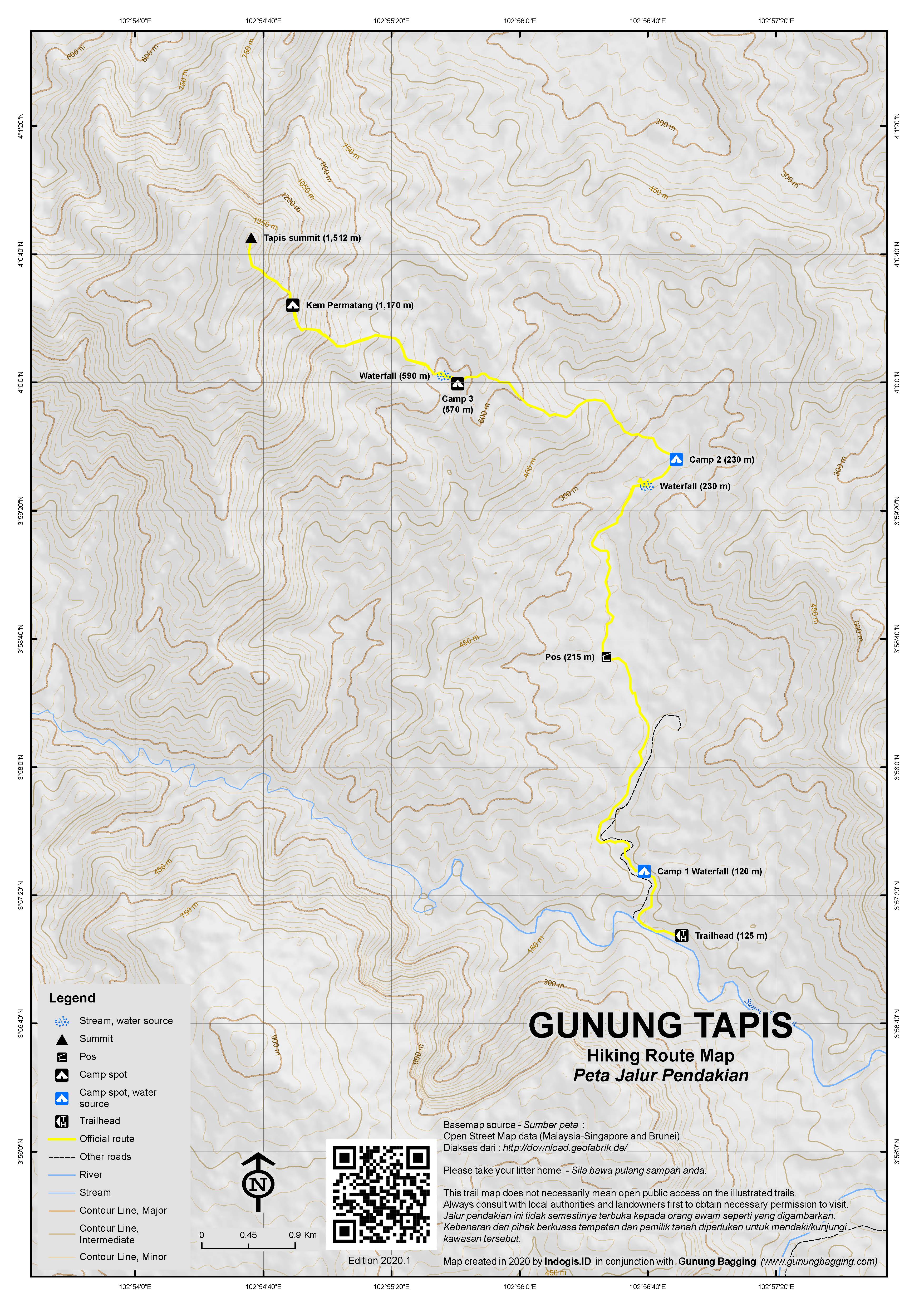
For a high quality PDF version of this and other trail maps, please download from our Trail Maps page.
Practicalities
- Getting there: For Malaysian domestic flights and flights within Southeast Asia, for example to Kuala Lumpur, we recommend Baolau. The nearest town is Sungai Lembing which is about 4 hours from KL by car and 40km from Kuantan. The nearest airport and bus station is Kuantan. There are plenty of hotels in Sungai Lembing.
- Guides and GPS Tracks: Want a PDF version for your phone? Looking for a guide? Need GPS tracks and waypoints? Gunung Tapis information pack can be downloaded here.
- Permits: You can register and pay for an e-Permit online from the Forestry Department of Malaysia website. RM10 for locals and RM30 for foreigners (in 2024).
- Water sources: Available as far as the waterfall (590m) just beyond Camp 3 on the old trail. Not available on the new trail so be sure to come prepared.
- We recommend Safety Wing as travel insurance for overseas travellers and tourists hiking up to elevations not exceeding 4500 metres.
Local Average Monthly Rainfall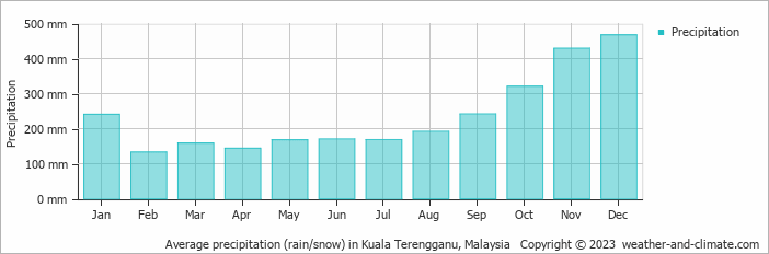
Location
Click on the blue arrow ![]() (top right) to see your current location on the map
(top right) to see your current location on the map
Sungai Lembing is a pleasant town full of hotels and seemingly quite popular with local tourists at weekends. We arrived late at night, ready to get started at 5am on a day-hike up Gunung Tapis. Earlier reports, based on the old route, suggested that it would be a long day, as we were not aware of the new (much shorter) route recently opened.
After a quick early breakfast in town at Anjung Selera, where all the 4WD drivers and tour guides tend to congregate, we were off. As the sky began to lighten on the logging roads, the scene below over morning mists in the valleys was quite beautiful but the 4WD was going fairly fast over increasingly bumpy and challenging terrain and through one or two rivers so I didn’t manage to get a good photograph.
We ended up after just over an hour in thick, deep mud, but not far from Camp 2 on the old route. As the 4WD could go no further due to the mud, and would probably have a hard time getting out of the situation, we decided to walk from there, trying our best not to end up knee-deep in mud ourselves, and generally failing! Admittedly, the mud here is a rather beautiful colour – Teh Tarik springs to mind!
After half an hour it turned out that our guide had never trekked along this old route and so he was unconfident of route finding and obviously reaching the summit and getting back in a single day could be much tougher than if we had been dropped off at the correct place. Yes, the driver had taken us to the old route, not the new one, but nobody had made this clear to us!
We decided to turn back and ask to be taken round to the correct trailhead, as nobody could guess the state of the old trail. After much discussion, the driver finally agreed. But first we had to get towed out of the thick mud with a bulldozer, which was bizarrely already on hand. Another 4WD arrived, driven by a man who clearly did know where we needed to be and he kindly led us there.
So much for a 5am start…. we didn’t get hiking on the proper (new) route until 10am! However as it is a 5 hour trek (up and down) we still had more than enough time to complete it. It was however cloudy by the time we got to the top. Very few leeches – just a single one at the summit, probably carried up there by another hiker.
Once back in Sungai Lembing we had a shower at our hotel then headed into Kuantan for the night. Our hotel in Teluk Cempedak didn’t accept our already paid Traveloka reservation so we headed to the city instead. On the way in we visited Gua Charas Panching / Sivan Temple (Buddhist), an impressive cliff peak surrounded by oil palm plantation, though the temple was already closed to visitors by this hour.
The next day was a rest day, travelling to Merapoh and preparing for our Gunung Tahan trek. We called off at the impressive Gunung Senyum (486m) en-route (‘Smile Mountain’!) which features some caves, a grave connected with local mythology, and some scenes straight out of an Indiana Jones film. It is also possible to hike to the top of Gunung Senyum but from a different direction and only really with an experienced local guide. Worth a stop at the very least.