
Facts
- Elevation: 3,031 m (9,944 ft)
- Prominence: 3,031 m
- Ribu category:
 Sangat Tinggi
 - Province:
 Bali
Bali - Coordinates: -8.3407, 115.5036
- Rating:

 (36 votes) Add your rating
 Loading...
 - Other names: ᬕᬸᬦᬸᬂᬅ
- Eruptions: 1808, 1843, 1963-64, 2017-19
- World Ribus ID: 69009
Photos


Bagging It!
FROM 2017- 2020, AGUNG REMAINED OFFICIALLY CLOSED DUE TO INCREASED VOLCANIC ACTIVITY. NOW IN 2023 THERE ARE NUMEROUS NEWS REPORTS SUGGESTING A COMPLETE BAN ON ALL MOUNTAIN HIKES ACROSS BALI EXCEPT FOR RELIGIOUS REASONS. THE REALITY MAY BE DIFFERENT (FOR NOW) BUT PLEASE CHECK WITH LOCAL GUIDES ON THE LATEST.
This Ribu is the highest point on the popular island of Bali and holds incredible spiritual significance for the Balinese. Folklore has it that when the deities made mountains for their thrones they set the highest peak in the east, the direction of honor to the Balinese. In every temple a shrine is dedicated to the spirit of Gunung Agung. The tapering form of cremation towers, pagodas, and even temple offerings bear the shape of a mountain, mirroring reverences for this holy volcano. Every aspect of Bali’s geography and ecology is influenced by the towering range of volcanic peaks that dominate the island. They have created its landforms, periodically regenerated its soil, and helped to produce the dramatic downpours which provide the island with life-giving water. The Balinese recognize these geophysical facts of life, and the island’s many volcanoes, lakes and springs are considered by them to be sacred.
There are two main routes to reach the crater rim which leave from different places. If you aim to reach the highest point of Gunung Agung without scrambling then one needs to depart from Pura Besakih (1,180m), Bali’s most sacred temple. The best guides are to be found in the nearby village of Selat. However if you are happy to reach the rim only which is short by about 150 meters from the very top, or are are a confident scrambler, then start hiking from Pura Pasar Agung (1,600m) which is Bali’s highest elevated temple. Views from both sides are just spectacular.
Significantly increased volcanic activity at Agung started in mid-September 2017 not long after hikers filmed minor fumarole activity in the crater. Since then there has been an exclusion zone extending several kilometres from the crater meaning no hiking has been legally permissable since. Thousands of local people have already had to evacuate. Agung was at the highest level of alert – (Level 4 AWAS) for a number of weeks and an eruption looked imminent in late September. However, activity then slowly decreased and the alert level was brought back down to Level 3 SIAGA (of a total of 4 levels). Local people began to return home and a small number even made religious offerings at the crater. In late November 2017, after some phreatic (steam-based) eruptions, activity increased again considerably, with a genuine magmatic eruption occurring and the alert level was been raised once more. What happens in 2020 and beyond is difficult to predict, but further activity is fairly certain.
Pura Besakih route
To reach the summit from Pura Besakih takes approximately 6 hours, and many people climb at night in order to reach the top for sunrise. Pura Besakih is not one temple but a vast complex of temples sprawling across the mountain side. For most visitors the first impression is of the hundreds of towering meru, their many tiered roofs of black palm fibre thatching pointing skyward. Their structural core, is an unobstructed square tunnel down which deities, ancestor, and spirits can descend on festive occasions to take their places in the shrines at their base. Pura Besakih is a landing field for the Gods.
The central temple in the complex, Pura Penataran Agung, is dedicated to the God Shiwa. Pura Batu Madeg (Temple of the Standing Stone), approached from behind the Pura Agung and to the left (northwest) is dedicated to Wisnu. Pura Kiduling Kreteg (Temple of the South Bridge) over a bridge and across a gully to the right (southeast) is dedicated to Brahma. There are nineteen more temples spreading up the mountain slopes, each with its own purpose and ceremonial season, but the three dedicated to the Hindu trinity are the most important. Almost every day village groups come to pray and collect holy water to take home for local temple ceremonies, or to pay their respects upon completion of the complicated cycle rituals.
Each temple in the complex has its own annual ceremony and approximately every tenth year the impressive Panca Wali Krama, a purification for the whole of Bali, draws almost everyone on the island to refresh their links to the Gods.
If you wish to be on the summit for sunrise then it is wise to spend the night prior to the adventure at one of the home stays that are easy to find at the parking area of the temple. Your home stay will also organize your compulsory guide that is absolutely essential for successful climb. Estimate six hours for your hike to the summit which includes 45 minutes of rest time, meaning that you need to start your extremely exhausting but most memorable adventure around midnight. The first 45 minutes will lead you past the mother temple (927m) , and then along vegetable plantations following an actual trek that is used by worshipers to reach the last temple (Pura Bangpuhan, at 1,180m) belonging to the Besakih temple complex. Once you pass the temple, cross the parking area and then the path leads slightly downhill before ascending past two recently cleared open fields. This will take a good 20 minutes ending at the entrance of the forest, (1,316 metres) where the actual fun starts.
For the next three to four hours a good torch or much better a high quality head light is absolutely essential, as the dense forest prevents any moonlight from penetrating down to the track. The first hour and half is steep but still comfortable and often broken by flatter passages across ridges. This first 1/3 of the uphill struggle ends at a point which we call the “super root ”, (1,723 metres) a very steep section across some massive roots offering good grip.
The following two hours are very tough, steep and often very slippery. Here one starts to realize why Gunung Agung is without doubt one of the hardest volcanoes in Indonesia to climb, as the path leads straight up towards the summit and not crisscross up a flank like found on most hills in Europe. At an altitude of 2200 meter the forest gradually gets less dense and with it the path starts to become stonier and often covered by loose gravel offering an additional challenge. After four hours of hard and strenuous slow climbing our so called base camp (2,622 metres) is reached. This is an area which offers very little space for two tents and is often used by local hikers as a resting point before heading to the summit for the sunrise.
The next section, which is a good 300 metres long, climbs just over 100 metres altitude and is the only part of the entire hike where utmost care needs to be taken. This is the only area where one could fall over a cliff and with it get seriously injured. The final hour of the climb continues to be very steep and frustratingly slow going. You reach the final cone of the volcano which is very rocky at the lower section. The last 100 metres before the first summit are not that steep anymore but offer terrific views of the highest point of Gunung Agung which is about 350 meters ahead to the East. Once again at this point extra care must be taken from the often howling trade winds which can gust up to 100km an hour. There are several cracks in the ground offering protection from these freezing cold winds. Especially during the months of June, July, August and September we were several times forced to quit here as it was simply too dangerous to continue with our quest. This first western summit is actually only 10 metres or less lower than the highest summit and is listed on the Bakosurtanal map as being 3,028 metres high.
The final 15-20 minutes along the ridge to the true peak are an absolute joy. By now the sunrise is only minutes away and the entire horizon is painted with the warm colours only found during tropical sunrise. Despite the glory in the distance one needs to watch every step along the mostly less then one metre wide track. Missing a step could easily result in a disaster as on both sides the mountain falls down several hundred metres. About half way across the ridge there is one last technical passage which requires the utmost of attention, as the path winds in the shape of a horseshoe around and up a recent rock slide. This section is very slippery and offers very little grip and is best conquered going up on all fours or downwards on your backside.
Once past this section, there is only 100 metres left to the summit of a very special mountain, offering some of the best volcanic views in Indonesia. The crater is an impressive 700 metres in diameter. For most Balinese Gunung Agung is very simply their holy mountain and only very few ever consider actually venturing to the top of this sacred volcano. The catastrophic eruption of 1963 killed thousands of people and left an everlasting deep respect for this life giving and life taking mountain of the Gods. Many maps still list Agung as being over 3140m high – in truth it is approximately 100 metres less than that – probably as a result of the powerful 1963 eruption.
Every summit is very special in its own way and Gunung Agung is certainly not different. What makes this mountain very different is the fact that after 6 long and extremely physically demanding hours you reach the summit of a mountain towards which every single building and temple on Bali is orientated. Not a day passes in the lives of every Balinese where not at least once a day he visits his temple at home for a prayer in respect of the holy mountain and Pura Besakih the mother temple.
Pura Pasar Agung route to the crater rim or summit:
Traditionally, the route from Pura Pasar Agung was used by tourists as an easier option in order to reach the crater rim only but not the summit. However, it is now possible to reach the true summit but you will need a guide who is experienced and knows the way and be a confident scrambler. The junction is about halfway up the crater rim route described below: straight on for the crater rim only, or west towards the true summit. Only recommended for confident scramblers.
There are always guides waiting at the car park of Pura Pasar Agung (1,600m). The hiking adventure starts at the car park with a welcoming or heart breaking 297 steps to, or from the temple. At the gates of the temple, guides will make an offering to the Gods, to ask for forgiveness, protection and a safe return from this sacred mountain. It would be terrific if you also show your respect and light up a few incense sticks, place them on one of the shrines and say your own short prayer as a sign of respect to the people and culture of Bali.
The path first leads to the left around the temple, past a couple of water reservoirs tanks, from where you have beautiful views of the temple. Then across a small opening in the woods and then immediately into very steep and dense high alpine rainforest. The track climbs steeply up a narrow path that is carved by deep ravines and littered by countless roots from magnificent tall trees often requiring hands and feet to scramble over. If you depart at 2.30 am for a sunrise at the summit then a good torch light is absolutely essential to illuminate the path. More practical is a headlight allowing you to keep your hands free.
After a good hour the forest gets gradually lighter and less dense and eventually the path passes a small concrete dam which channels rainwater from the higher mountain region into PVC pipes back to the reservoirs just above Pura Pasar Agung. This normally marks the first third of the track. Here the path flattens for a couple of metres and offers good views on the return journey.
After a short flatter passage across a small ridge the path now inclines again rather steeply, but this time up the first rocky surfaces. Here the forest is not as dense anymore and every metre altitude gained offers increasingly better views of Bali far below. At times this section can be slippery, especially after recent rainfall. There are several short and steep drops requiring your hands for additional safety, but definitely nothing to worry about. This next section will take about 1 hour of continuous hard steep hiking ending once the vegetation gives way to pure volcanic rock surface. If you depart Pura Pasar Agung around 4 am, by now the horizon will be lit up by early morning light, making the remaining route clearly visible.
At this stage (2,425m), for those who wish to turn left and scramble up to meet the trail from Besakih to the true summit it is crucial to be lead by your local guide as there is no more clearly visible path ahead. The only signs of this side trail are countless graffiti painted by local mountaineers over the years. If you are on the way up, and should for some unexplained reason become separated from your guides then simply follow these markings up to the top. However on the way down those markings are rather difficult to see and should you be unlucky to experience a weather change with thick mist and fog, then you are in deep trouble.
Many simply opt to continue to the more easily-reached crater rim itself. The final third of the track to the crater rim is very steep, rocky and at times very slow going and often slippery, but what a small price to pay for the dramatic scenery unfolding in every direction. Two-thirds of Bali including the coastline as well as the neighbouring islands of Lombok, Nusa Lemongan, Nusa Penida and Nusa Dua far below you. Then to the West the entire mountain ranges of Bali including the towering volcanoes of East Java in the misty distance. Finally ahead of you a rugged mountaintop with the the peak of Gunung Agung high above to the left, which is separated by a deep – and impossible to pass – volcanic ravine.
The last third will take a good 1 to 1 1/2 hours of very hard work, and concentrated high altitude climbing. The final 75 metres are not as steep and the going gets suddenly easier which increases the personal satisfaction. The view from the rim (2,866m) is simply breathtaking. Volcanic scenery at its best. Here your guides will make offerings and prayers to the Gods and thank them for protecting everyone on their journey as well as for the joy received by reaching the top.
Eventually the decision has to be made to start the long, hard and strenuous journey back towards Pasar Agung – a journey that will take about as long as it takes to get up.
Less popular alternative routes
There are at least two other possible routes to the crater rim of Gunung Agung, but they are infrequently used, with few if any signs and vague paths requiring more time – quite possibly 2 days and 1 night. If you can find a genuinely experienced local guide for either then adventurous hikers may wish to try them but going alone would be unwise as it is easy to become lost and they will probably be overgrown and dangerous in low visibility or poor weather.
The route from the east starts in Kedampal at an elevation of around 750 metres. It reaches the rim on the eastern side at an elevation of around 2,940m and it seems unlikely you would be able to join up with either the Pura Pasar Agung or Besakih routes due to the terrain, meaning that bagging the true summit from this direction is probably not possible. The route from the north starts in Pucang at an elevation of around 900 metres and appears to meet the Besakih route at the western peak on the ridge before the true summit.
Good viewpoints for photographs of Gunung Agung
Obviously not everyone that is interested in the volcano has the energy or the interest in making the gruelling ascent. Therefore we thought we would add a small number of good places that are accessible and offer decent views from afar.
Jemeluk Beach, Amed, East Bali. This lovely, laid-back area is a great place to gaze up at Gunung Agung, especially during late afternoon and sunset if the sky is relatively cloud-free. You can photograph the volcano from the beach itself or from ‘Jemeluk Viewpoint’ which although only 20 metres or so above the sea is a very nice spot. You can also get to the Gilis quite easily from Amed, with daily fast boats.
Pura Lempuyang (Lempuyang Temple), East Bali. This hillside temple complex with numerous steep stone stairways on the slopes of Gunung Lempuyang has become immensely popular in the last couple of years thanks to Instagram. Located about 30 minutes before Amed (assuming you are driving out there from the Denpasar or more central region), Agung is clearly visible on the other side of the valley and looks especially enchanting from the entrance portal known informally as heaven’s gate. The recent increase in popularity has meant long queues, numerous ‘fees’ to pay and a crass commercialization of what is a very special location. However, if you go before 8am to beat the crowds, put up with all the different mini-payments required, and are lucky with the weather then you will certainly get some superb photos.
Bagging information provided by Heinz von Holzen, updated by Dan Quinn (May 2020)
For a wide range of tourist activities in Bali, try Bali Tour Host. This includes mountain treks and plenty of other worthwhile trips including culture, history, temples, islands, and so on.
Trail Map
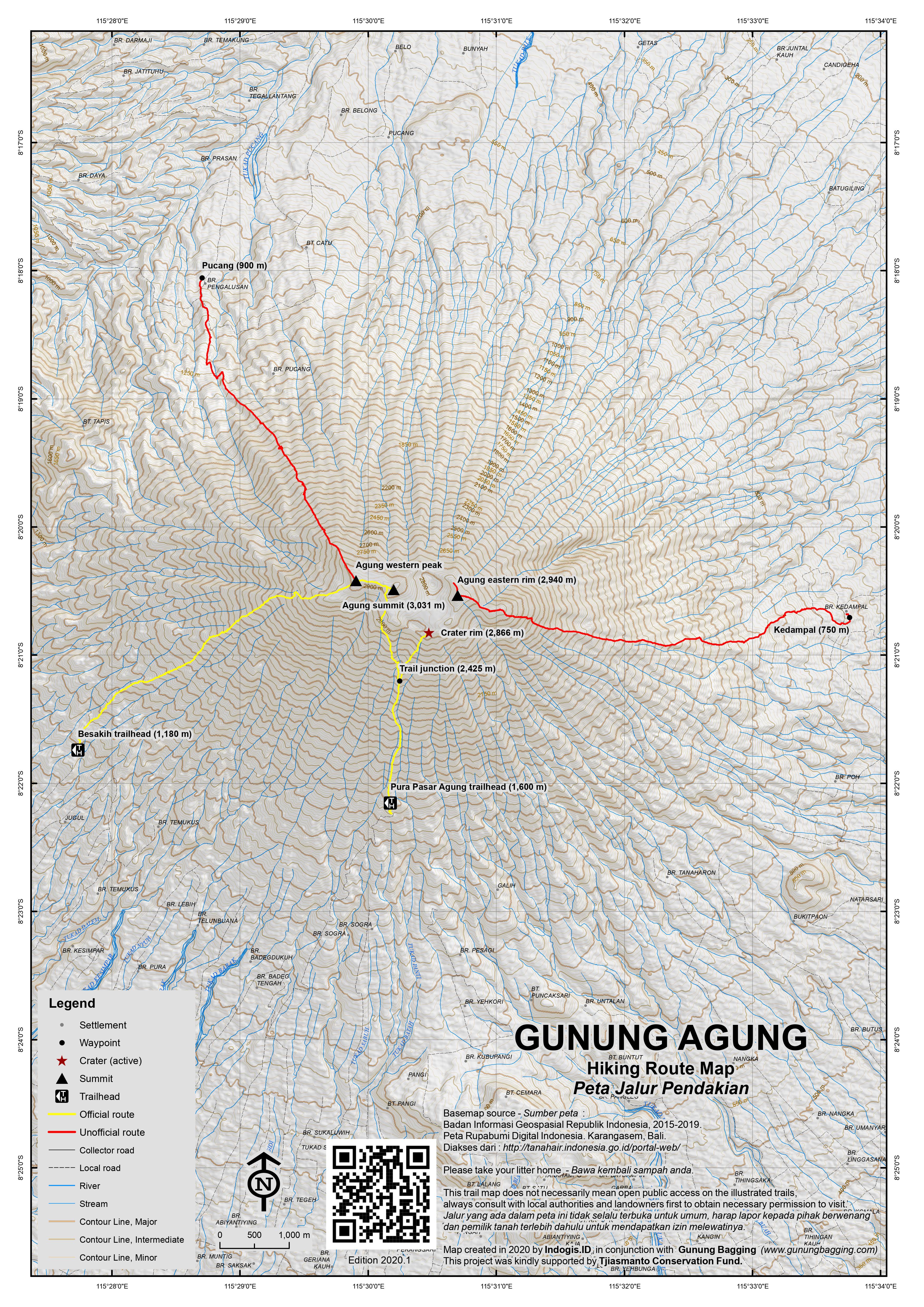
For a high quality PDF version of this and other trail maps, please download from our Trail Maps page.
Practicalities
- Getting there: For domestic flights to Bali, for example from Jakarta, we recommend Baolau. Car hire is easy and cheap in Bali and drivers should know the starting points.
- Guides and GPS Tracks: Want a PDF version for your phone? Looking for a guide? Need GPS tracks and waypoints? Gunung Agung information pack can be downloaded here.
- Trip planning assistance: Would you like Gunung Bagging to personally help you in arranging your whole trip? Please contact us here.
- Permits: Not necessary but have a photocopy of your passport just incase.
- Water sources: Take sufficient supplies with you.
- Accommodation: Try the Booking.com map above or use this link to search for suitable hotels, homestays, resorts and apartments for your trip.
- We recommend Safety Wing as travel insurance for overseas travellers and tourists hiking up to elevations not exceeding 4500 metres.
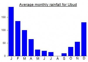
Local Average Monthly Rainfall (mm):
Location
Click on the blue arrow ![]() (top right) to see your current location on the map
(top right) to see your current location on the map
Origins and Meaning
‘Great’ mountain in Balinese/Indonesian.
i did summit via pasar agung. it took me 9h up 7h down. i was dying. it was cloudy all day, couldnt see anything.
Just got back from climbing Agung and I have to say its awesome to be back in Bali after Australia banned travel for the last 2 and a half years.
I didn’t actually realise that you can climb Agung without a guide but for anyone interested all you have to do is pay the registration of 100k rupiah at the guides hut at Pura Pasar Agung car park and then off you go. I don’t know about Besakih though that may be different.
Anyways, I arranged a guide but I didn’t know at the time that you have to specify that you want to go to the “summit”. When you say you want to go to Agung most guides think the crater rim so be sure to specify which you prefer. I almost fell over when I heard the cost though. The going rate these days is 1 million rupiah for a guide to the summit but thats whether its 1 person or 3 people. Over 3 people I think they just add an extra 100k or so.
I met my guide who I can highly recommend, Gede Sana (WA – +6285239001424) at the car park of Pura Pasar Agung and we set off around 2am. We made good speed and were out of the trees after 30 minutes. Around 4am we realised we would be way too early so we stopped for almost an hour around 10 minutes before the top. We topped out at 550am and if we didn’t take the 1 hour break we would have taken 3 hours to get to the top so 3am start would be a better option if you don’t want too many breaks. I do have to say that there isn’t really a path and even though they do allow you to go without a guide I would say its easy to get lost, especially if the clouds come in. There are some ravines you have to cross and it’s quite easy to end up in the wrong ravine.
We spent about an hour on the top enjoying the views and chatting with fellow hikers that had come up from Besakih. All up there were 10 of us on the summit – 6 bules and 4 guides. As the general rule of thumb goes take the time to the top and divide it in 2 and thats your down time. If we didn’t take the 1 hour break it would have been around 3 hours to the top. We took 90 minutes getting back to the car park from the summit and Gede told me it was the fastest he’d ever gotten back.
Even though it cost me almost 1 million rupiah to climb the mountain I had a great time with my guide and a genuinely awesome experience. We had the entire Pasar Agung route to ourselves and it felt like a real adventure.
There is a guide named Wayan Botak who can guide people around the crater rim and do a full 360 of the top of the mountain. Apparently its a 3 hour trip so maybe next time.
Hey,
Thanks for the detailed trek description. It helped me to prepare for my trip.
I did it too and had an amazing experience. The view on Agung was the best, seeing the milky way and unlimited stars the whole night.
I realised that many people online say they’ve been to the summit but actually went to the false summit instead.
You can read up more on the detailed guide in my blogpost on : http://www.yonderingsoles.com/2017/08/07/mountagung/
I was hoping to hike up Gunung Abang this weekend – the 2150m (ish) forested peak 10km to the north-west of Agung. Abang is the highest point of the outer rim of the Batur caldera and hides a large portion of Agung from those hundreds who every day look east from Batur at sunrise.
Anyway, given the likelihood of a large eruption on the next few days I couldn’t risk (a) getting covered in ash or (b) having flight cancellations and therefore missing work in Jakarta early next week. So it’ll have to wait until next year.
Thousands have evacuated, and if the eruption is anything like what happeneing in 63-64 then it could cause significant problems both for local people, the tourism industry, and aviation for a year or more. It could also reshape the top of the mountain considerably – perhaps taking the elevation down to under 3,000m. At least the authorities have warned people to leave their villages in time – most seem to be heeding the advice.
Just summited Gunung Agung via the Pura Pasar Agung route. Engaged Ketut Bawa thru his website http://www.bawamountagungtrekking.com /email ketutbawa9@yahoo.com.
Very professional and was able to accommodate my request to start at daylight
It follows the crater rim Route and forks left about 1-2 hours after the start. Route is well marked with white painted circles . I would call it class 2- 2+ Scrambling for the most part. Crux is probably a class 3 but has a rope that seemed well protected by 2 anchors (pegs) which you could pull up on.
Would definitely recommend a guide despite the well marked circles as the route is not that obvious (especially in the dark). Its about 3-5 hours up and 3- 5 hours down.
One of my best hiking in Indonesia
Just did the Agung hike to the True summit via pasar agung route and it is such an great route
I went with an amazing guide Ketut who organize an excellent trip and also a very enjoyable partner during the hike. A patient and charismatic local who spoke good english.
We start from pura pasar agung(1500m) at 12 midnight. The route starts first two hours of rainforest which ends in around 2200m . Then as the landscape begin to change to tundra i took another half an hour to reach the intersection. The route that continues up is for the crater rim which is another 3 hours of hike.
We took the route to the true summit which Is a dramatic traverse to the left. This route is fantastic for me who used to climb all around Indonesia as well in the state . The traverse to the true summit is very exposed with no vegetation as cover and starts at 2500m which consist of sometime moderate scrambling. This reminds me of a vie ferrate route in Mount Kinabalu but without the ropes.
It is extremely dangerous for someone to took this route without a guide since its very east to got lost(few markings). Around halfway up we encounter some light rain and dense fog however, my experience guide Ketut confidently lead the way and guide us to a small cave for rest from the rain. It took around 3 hour for me to reach the true summit for me from the intersection.
I would highly recommend Ketut as a guide because he’s very strong guide, knew the route well, offers great service (best breakfast on the summit) , and most importantly gave us the best price worth.
You can reach him by phone +62 852-0372-3242 or his Email : info@bawamountagungtrekking.com / ketutbawa9@yahoo.com
He also runs a modest website if you need further info http://www.bawamountagungtrekking.com
Dear.. Mr Reggie ..thank a lot ,for trust in me as your guide to climb mount Agung Bali. My first principal for my customer is ;
Safely , comfortable , satisfy and you will climb with me directly as your guide
I’m ketut subawa as a local trekkin guide
And I offer to :
Trekking Mount Agung
Trekking Mount Batur
Trekking terace rice field (sidemen area)
Transport
And Organize for :
Rafting adventure
Ticket speed boat to gili trawangan, gili air , gili meno , nusa panida, nusa lembongan , and ceningan
Trekking Mount Rinjani ( lombok )
For more infomation contact me :
Email : info@bawamountagungtrekking.com /
Ketutbawa9@yahoo.com
Ph / WA : +6285203723242
Web site : http://www.bawamountagungtrekking.com
Just got back from a fantastic day on Gunung Agung. We are from British Columbia, and have hiked and climbed extensively in the mountains of western Canada. I can say that Agung is very worthy mountain to climb. Awesome day. We did the true summit, and contrary to what is stated in the information above, we started from Pura Pasar Agung (i.e., it is entirely feasible to get to the summit from Pasar Agung…we did!).
Starting at Pasar Agung is actually a very good idea, because from there you hike up the trail towards the crater rim, just like everyone going up to the rim. At a point that is roughly halfway to the rim, there is an alternative route that veers off diagonally to the west, towards the summit. That is what we did, and it was a fantastic route. I would highly recommend it to anyone used to hiking/scrambling on steep rock. Be advised, this is not a beginner hike. If you are not accustomed to hiking and scrambling on steep rock for long periods of time (i.e., a full day), you might want to rethink it. The beauty of this option is that you can do half the trail before deciding if you are up for the summit. If not, then continue to the rim.
Contrary to what seems to be the norm, we started at dawn (5:30 am) and hiked in the daylight. Awesome. Highly recommended. It was beautiful hiking in the early morning, watching the sun hit the rock. We summited about 10:30 am, then back to the car at about 2:30 pm. Total hiking time, all in, was about 9 hrs. The route is about 30% forest, and 70% open volcanic rock (very cool rock formations).
It was a beautiful blue-sky day, and watching the clouds rising up the slopes was surreal. Views from the top are amazing. At 3000+ m, you really feel like you are high up. Again though, the route requires scrambling on steep rock, and requires reasonable fitness to enjoy. The entire route is more or less straight up, or straight down.
Our guide, Nyoman, was amazing. Highly recommended if you are looking for an Agung guide. He is a full-time professional guide, knows what he is doing and where he is going, and has done the various routes hundreds of times. He will pick you up virtually anywhere in Bali, feed you breakfast, take you up any of the various routes that you choose, then bring you back to your accom. Hard to beat that. He has reasonable English, and can be contacted/booked via email: nyoman_mukti@yahoo.com, or phone: +6285 238 548 412. We paid 1.7 million Rp all-in (transportation, all fees, breakfast/snacks, guide) for 2 people to the summit (rim is cheaper).
Enjoy!
dear,visitor….
thanks you for your coopration to advertising this new product mount agung hike via pasar agung to real summi(new alternative route called)
this accessblty found by wayan dartha on 2013 with russian guy. it coud more fun and elegant for the information could please klick the link below http://www.darthamountagungtrekking.com
now also avialble camping option if you like to enjoy sunrise and sunset at agung.
Hi Adventures , hows doing ? , Mt Agung is one of the most exciting trek and most extremmes dream of adrenalin in Bali , I was there on top 3 times and was fail one after one of my friend got a knee problem ,then we decided to back down to our camp. we were sleeping in the midle of the trek just in between the mountain rocks . the paradise of cloud just like the cutton wrinkle ( Cyrus, cymulus ets blanketing you just bellow your sleeping bed . I was taking late trek , I was start around 8 am local time .I felt the inspiration. There’s a love , a peace , a heart and paradise of life .
if you go by your own or in a group, doesn’t cost you much. we just paid official for a district local tax about US $ 15 / pax . and the route is very clear or bring GPS / Google map to trek up . there’re two main routeto trek. one from the Tample of Besakih and other one from Pura pasar Agung sout eastern part. both route are Ok. have to try guys and enjoy your trip
regards
Billy Sangkreg
Email ; billysang72@yahoo.com
Hello billy, is it possible to go only my own and camp at summit or along the trail? im planning to go next month.
Anyone wants to join me to climb Agung this sat 17 Sep? Plan is to go via Pura Pasar Agung. Let me know – my no is 081-19404509 or email eskohar@gmail.com.
Regards,
Eugene
Dear mountain climber lover,
Mudigoestothemountain might be not famouse one as not many comment about it.
One or two are interested to try from north side. No body could give info about it.
Should you need detail of it please submit your email to : mudigoestothemountain@gmail.com
We design that trip ofcourse we will able to explain clearly.
Thanks,
Mudi
I will climb Mount Agung with Wayan Dartha from Pura Pasar Agung in Saturday 28 November start at 6 Am. If you want to joint pleace contact me 081272850838 or albertus.widiantoro@gmail.com
Hallo guys nice to meet you every body here.
some one wouod love to hike both of mountains mt ag6ng 3142m above sea level and mt batur 1717m above sea level and we also provide bali tours driver please joint and contac me at :
Name : wayan dartha
ph/whatshapP : +6285237008513
Email : agungguide@yahoo.com
web : http://www.darthamountagungtrekking.com
Hi,
I s it advisable to trek Mt Agung during the month of January???
I will be back in Bali during the 8th to 15th of January 2016 and am planning on trekking on the 11th via the Pura Pasar Agung route.
I will be doing the trek alone and would therefore need a guide. Please quote me the price of guide plus pickup from Seminyak.
Makasih banyak
Joseph
Hey Joseph,
I’m not so sure about January as it rains a lot during and the path will be very miserable if it does rain. Pasar Agung route winds its way around the mountain so you cross a lot of small ravines which I’m sure would be very slippery and not fun to be climbing up. Your best bet is to get in contact with the guides and see what they have to say. If you want an Indonesian speaking guide the price is much lower than for an english speaker. Seminyak is very far from Pasar Agung and if you start at midnight from there you’d probably have to leave Seminyak around 9 or 10pm. It’s better to stay at the cap park of Pasar Agung. They have rooms there with mattress’ albeit quite old but atleast you can have a sleep and not spend 3 hours in the car in the dark. Guide fees vary from around 600,000 to much more but just decide what its worth for you. 2 posts under this one you can find some contact information. I used a guide by the name of Kadek Budi he can’t speak much english but he was a great guy to go to the top with. You can check out this link to see what its like and a small description
https://www.instagram.com/p/-V439RCohI/?taken-by=ryanmazure
All the best 🙂
I climbed Mt Agung on 6 October 2015.
I was new to this and I think it worked in my favour. I used a guide from Wayan Dartha and whilst I don’t normaly promote companies, the service was first rate and I will make an exception. Email me and I will pass on the details.
After some fried banana we set off about 0030. It was a hard slog through the dusty forest before we rose above the tree line. This was the point that I confirmed I wanted to take the alternate route to he summit.
It was good to feel the temp drop and looking at the lights during the breaks was amazing.
Got to the summit at about 0430. (3.57 all up). In retrospect it would have been smarter to slow it down and get to the top an hour later. I thought I had been cold before but the wind chill was frightening. I live in a reasonably cold area and have been skiing but that was nothing compared to this.
seeing the sun rise whilst obscured by Mt Rinjani is something I will never forget. Likewise seeing the island spread out below whilst lumina ted by lights.
A few got to the summit after dawn after climbing the longer route. A few more got to the lower crater rim, however many more turned back.
The walk down was very tough and by the end I was struggling to walk.
All in all it was a great experience that has inspired me.
Hi Paul, contact details of Wayan would be useful. I am hiking tomorrow.
Dom,
I used Wayan Dartha treks and it is highly recommended. He seems to organise the guides and ensures the treks are divided equally.
I trekked alone and had transport and it cost 1.7 mil. It was a lot but I feel got what I paid for.
Phone/whatshapp : +6285237008513
Email : agungguide@yahoo.com
Web : http://www.darthamountagungtrekking.com
All the best
Paul
HI Paul,
Would you happen to have the contact info for wayan? Thanks!
I trekked alone and had transport and it cost 1.7 mil. It was a lot but I feel got what I paid for.
Phone/whatshapp : +6285237008513
Email : agungguide@yahoo.com
Web : http://www.darthamountagungtrekking.com
Hey guys,
Anyone know if it’s possible to go to the summit from Kubu village in the north? I was in Kubu and went to the top of the village near the temple and talked with some locals there. They said the road/track continues on for 4km up then you park the bike and can go to the top. Around 4 people from this top village told me its possible. Then as i rode back to the main road i asked the villagers down below and they said it’s not possible from here. I am optimistic in believing the top villagers and that there is a route to the top via the north. Anyone else know about this or have heard about it? Im not in Bali long enough to give it a try but would be very cool if it is possible.
Hi All
I’m going to be climbing Agung in mid-September and require an excellent guide! A current phone number with your thumbs up would be appreciated.
I would like to get to the true summit but am unsure if it requires more experience than I have
(I can hopefully make up with a gung-ho attitude and good equipment)
Jas
Dear Jas,
I recently climbed to the crater at 2,866m via the Pasar Agung route. It was a challenging climb with some very steep and windy conditions at the top. The views from the crater were stunning.
I have a reference for a great guide called Wayan, who speaks perfect English and has been guiding happy hikers up and down the mountain for many years. I am sure he will be able to take you up to the true summit via the Pura Besakih route.
Wayan: 085237250607
Does Wayan has email address? Thanks, Quinn
I want to climb this peak with no guide which I’m sure I’m capable of. But I did some reading that at the parking lot of Pura Besakih there’s some sort of local mafia that are quite aggresive and do not allow you to go.
So my question is if easy to get rid of those or should I not go there at all ?
Maybe Pura Pasar route has less of those issues ?
Climbed this beauty today with no guide from Pura Pasar Agung temple to the very top.
I would not recommend going this route at night for two reasons. One is that it gets a little steep at some parts, much safer in a day time. Second reason is that even though route is quite well marked from the point where it splits for the summit and the crater, those markings are far away from each other and would be difficult to spot at a night time.
It’s not the best mountain for begginers, but as long as you are careful, you’ll be ok.
Some practicalities:
Left Ubud 4am, arrived at 6am with scooter (one scooter and for two people was no problem, road is in good condition).
I read alot about local gangs that aggresivelly force people to take guides. When I got there I was asked if I wanted a guide, but when I refuced I was asked for 100000rp donation. Those who were asking were really polite and not aggresive at all, so not big deal. I’d rather pay 50000rp per person for an official entry ticket, but world is not perfect, what you gonna do about that.
It took about 3hours 30min for the summit and 4 more to come back on a slow pace.
Navigating was quite easy. The most difficult is to find the entry point for the trail. So when you climb the steps to the temple enterence dont go inside, but turn left and walk around the buidings.
I’d say leaving at 6am is great time to go, there were few people on the trail and none on the top once we got there.
Great that you did it alone, Karolis. But in saving the guide’s fee you presumably paid a high price: long-distance visibility and sunrise which you only get with a good guide after a night climb. For most people, making this summit is a once-in-their-lifetime project. They should be aware that around sunrise (and sunset) you normally can watch Rinjani to the East and Raung to the West very clearly (see my pics on this page). They disappear within minutes after the sun comes into the game and transports megatons of water molecules in the atmosphere over the ocean.
I’ve made it to the summit on March 24th. via the new route.. it was my first mountain hike ever. was very challenging and at some point was cursing my self, but quitting was no option. after 5 hours i made it with my guide (wayan widi) to the summit we were the only ones to arrive for sunrise. another group arrived later after we started to head down.. the way down was far more challenging but i enjoyed it more we took 4 hours to reach the temple..
was first of a kind experience for me and going to doit again on ringani next week 🙂
Thanks for sharing, the main article and comments are very helpful. I’m planning a hike early Jan, right after NYE, but still cant decide which traill I’ll take. Both seemed very interesting and has it own charm! Would it be possible to take different route to go up and back? I’m thinking to go from Besakih and back to Pasar Agung. Anyone tried this before?
Thanks!!
Why does everyone every says you need a guide? I did it Yesterday with my GPS Phone as my Guide starting from Besakih. Had no serious trouble on the way expect for clouds wich reduced the sight to 2 Meters and strong freezing winds. I passed 2 small groups and the guides seemed not be happy that i do it alone. However, on top the clouds dispersed and the views where amazing and for a hour i was the only one there before the guided groups arrived. They took some poser pics and after only 30 min the guides urged them to descent. I stayed there for an hour more to enjoy the cloudless views over Bali. The descent was the hardest part of the Track.
If you have experience in climbing mountains you really dont need a guide expect for finding the route maybe. In the begining there are some forks. But for the most of the Track you can not get lost because the trail follows a narrow ridge. Of course its more dangerous doing it without guide and definatelly nothing for beginners but there are way more dangerous hikes in Indonesia. I personally enjoyed the freedom, especially on top. Guides have seen the views over 1000 times and want to be home as soon as possible.
Thanks for that Alex! The reason you’re encouraged to use a guide is more or less that this is Bali and it’s a few people’s business.
hi alex. taking a guide i think is a necessary evil. sure on your own is great with the solitude but who saves you when you roll your ankle 3000 meters up.my experience a few months ago .we were the last to descend out of all the groups and we came across a french guy that had rolled his ankle. had he been behind us then he would of spent 24 hours waiting for the next group to arrive to save his sorry arse.our guide called his mates who were all guides and they came up and stretchered him off.
if anyone chooses to go on their own please at least let someone know where you are going and have a phone with you.
i just climbed this brutal beast 2 days ago from pura besakih. at present the trail is closed from purah pasar agung temple due to religous reasons and wont be open again until mid november.so basically they close it in the climbing season and open it in the rainy season.go figure.
anyway it hasnt rained much in 3 months so the trail is very slippery and dusty.its also a 2000 meter height gain which is defanetly one of the toughest treks you will get in indonesia.i struggled my way to the summit and back again with a dodgy knee which i expected with not too much trouble.i had a great guide his name is gede which may not help much considering in bali everyones name is either wayan or gede.all the info from evereyone else above is fairly accurate.its a shame that most wont come prepared since they are in bali holiday mode.there were maybe 20 others on the mountain and i was shocked at how unprepared most of them were.a few guys only had a t shirt and shorts and were freezing at the summit. what do you expect at 3000 height meters.coming back down i came across a french guy that had just rolled his ankle ( possibly broken). his shoes were some cheap cross trainer and his guide should have never accepted to take him up but hey, they will do anything for a dollar. we spent 3 hours trying to get him down the mountain and only succeded in getting him about 100 meters. thankfully my guide phoned some friends and got a rescue team to come up and stretcher him down.we left him since there was not much more that we could do.he was in for a very long day and possibly another night on the mountain.all his plans for his holidays are totally ruined now because he was too lazy to get himself some decent footwear.oh well we all learn.for sure i have done some stupid things on these volcanoes and paid the price.
the 3rd route is very clearly marked now and it looks like a great option if you done have any fear of heights.no way i could do it.the ridge walk near the summit was enough to test me.
overall a great experience and a must for hikers( with a jacket and proper footwear).i used balisunrise tours.they will pick you up and drop you off wherever you are and organise the guide for you.not cheap though.better to do it in a group. on your own will be 1.5 million rupiah.
Hi there. My husband and I are going to Bali to hike Agung next year , I have been looking at Bali Sunrise to take us , were you happy with their guides and levels of safety ? thankyou so much
hi bek. yeah i was very happy with sunrise tours. im sure there are cheaper ways of doing it. but it guarantees that you will have a guide to yourself and wont have any transport problems. i had a great guide but i dont know if they use the same one everytime.safetywise i think its fine. sometimes it can get too windy to walk the summit ridge but im sure the guide will know this and make the right desicion.good boots are a must otherwise youll be sliding all over the place.great fun and worth it.
Does anyone know something about the routes to climb from the east and from the north.
They are mentioned here:
http://wikitravel.org/en/Mount_Agung#Climbing_routes
and here:
http://www.openstreetmap.org/user/Thomas%20Ulrich/traces/1421269
http://www.openstreetmap.org/user/Thomas%20Ulrich/traces/1421270
These require camping for a night but that is fine by me.
Heres my report 🙂 Contacted Pak Wayan who arranged for me to climb with Gede whom I honestly think is one of the best guides I have been with. We climbed via Besakih. Started at 11pm from the 2nd temple, with Gede offering prayers in the dark eerie courtyard. The climb starts off gently and soon it becomes apparent you are moving upwards in a spiral. In the dark, its hard to see the terrain you are walking on but it becomes apparent coming down that there are some areas you will be walking on loose black soil. Gede was amazing, his pacing is slow and sure, we talked while walking and soon 2 hours had gone by. By the 3rd, we were too fast for sunrise and camped by the big rocks circa 2500m, and spent the next 3 hours building a fire, having a cup of coffee and eating cup noodles that Gede brought. He had lugged all of that food up with him!! We picnic-ed till 5am and slogged upwards to the summit. It becomes harder as I went up and soon I was scrambling on fours. What made it hard was the complete lack of sleep and soon the strong cold winds and the exertion just made me giddy. Its just so difficult looking at that false peak and thinking how close it looks but it never came! However, slogged to it, and soon it becomes apparent that the real summit was a good 30 mins more to go. It was 615am by the time we crossed those ridges and finally arrived at the summit. Gunung Agung is certainly scary coming down! Besides the loose sand on the 75degree slopes you have to traverse that can just cause you to slide off the edge, the strong winds and the complete lack of sleep just makes it one of the hardest challenges you face. Cost-wise, its definitely one of the more expensive mountains I have climbed, but for Gede’s company and the sheer experience of climbing the highest and most significant mountain in Bali, its worth the money. We did it in less than 7 hours in total, but we were quick coming down (i needed to catch a ferry). Definitely, not a mountain you want to mess with by coming from the beach wearing sandals, shorts and a t-shirt. Come prepared- winds are cold. The trek down requires proper shoes with well defined threads. One slip is all it takes and it is very easy to slip up coming down those rocks. Bring a pole, you will need it coming down loose soil. Its a mountain you can pace yourself, and as long as you go slow and constant, you can make it in good time.
Thanks for all the helpful info! Would you mind sharing what you paid for the guide, or in your experience what would be a fair rate for a guide to the longer peak?
Transport through and fro is expensive, I recall paying something like 600k for it. I understand why they charge so much, the person needs to spend the night there and most groups come back in the afternoon & I heard that a group of Singaporean students even crawled back the next night!! Mine was ecstatic I got back before 9 and earned his fat pay check that quickly. Guide fees was 900k. It is an expensive mountain to climb, but like I said, it was worth it considering it is Agung. I wouldnt do it guide-less. Going up is fairly easy with light, but coming down has different forks that might get tricky. I certainly will not venture into a mountain I have never been on in the dark. Having said that, I would not mind doing fast one in daylight again. Its a good 4 hrs to the top and 2 plus down for fast hikers.
Hi..
Just to inform that the option #3 is the shortest way to reach the real summit. The path is quite hard and challenging. It is about 4,5 hours. If u don’t like to go down through the same path, u can go down through Besakih Temple.
Hi Wayan, me and my friend who me climbing agung soon on 26July, and we are looking for a guide. do email me if your keen!
Nicholas
I’ll be in Surabaya, Indonesia in 21st of march, been thinking of going to Bali for hiking Gunung Agung. I do not have a lot of money so i’m thinking of doing the trip like a backpacker. i’ll be doing this alone, so Id want friends, anyone?
being that you will be in surabaya.wouldnt it make more sense to do one nearby.theres some great ones not far away. ie.. bromo,semeru,arjuno,penangunggan.
Hello everybody,
Is it wise/feasible to climb Agung early January? Is January weather around Agung generally conducive to climbing? I’m thinking of climbing Agung via the 3rd route described above.
Marcus
Some say the route via Pura Pasar Agung was easier vs. Besakih. I am a bit confused.
It’s a few years since I climbed the Pura Pasar Agung route, but from memory I think the Besakih route is harder mainly because it is longer. The Besakih route involves 1900 metres of ascent and descent in a single 11-hour hike, which is bound to be taxing. But as long as your guide keeps you on the firm track on the upper slopes, you should have a solid footing all the way. The Pura Pasar Agung route is a few hours shorter, but it has more sandy and pebbly sections that sap your calves just to keep your foot planted.
So which one suits you would depend on the kind of fitness you have, and also on the weather- the Besakih route is much more exposed. In my opinion, the Besakih route is worth the extra effort for the 360 degree views.
In Besakih, Pak Mangkumo’s homestay is a pleasant place to stay.
There’s now a paved road from the main Besakih temple car park up to Pura Pengubengan at 1150m- about 15 minutes drive instead of a 1 hour walk. The trail starts about 30 meters before the large car park in front of Pura Pengubengan.
I had a trouble-free six hour climb up the conventional route with my guide Komang (hp: 087862012320), but he did tell me that strong winds had forced his party to stop short of the summit a week earlier. Other guides are Badra (hp 08123651066), a senior guide in Besakih, and Wayan (hp: 085238544199) in Selat.
GPS heights were 2610m for Puri Agung (a large, sheltering rock which offers the highest feasible camp site), 2948m for Puncak Satu (where the path shallows out onto the final ridge), 3032m for Puncak Dua (an intermediate top) and 3045m for Puncak Tiga (the true summit).
Although the hike is somewhat long and arduous, the terrain on this route is not difficult compared to other big Indonesian volcanoes or compared to the Pura Pasar Agung route up to the Agung crater rim. The forest path is very well-defined and the higher slopes have firm rocky footrests rather than the subsiding scree common elsewhere. The only worry would be strong crosswinds on the summit ridge.
The dawn views from the summit were superb. Just looking down the slopes of Agung over the surrounding villages was giddying. I did not quite feel as if I was in an abode of the Gods, but I did feel as if I was in an abode of people who abide in very high places.
It was also good to see the mountains of Central Bali after clnmbing Batukaru the week before. Looking from Agung westward, Batukaru (2274m) is the cone shaped-mountain on the left. Beside it is Adeng (1812m), then the bigger shapes of Sangihan (2092m) and Pohen (2063m), then the smaller tops of Lesung (1860m) and Tapak (1905m), which overlook Lake Tamblingan and Lake Buyan respectively. Somewhat to the right is the large mass of Catur (2096m), which overlooks Lake Bratan. The only lake visible, however, is Lake Batur to the north, between Mount Agung and Mount Batur. Far to the east is Gunung Rinjani in Lombok and to the west Gunung Raung in Java.
Visitors to Bali who enjoy hiking and have the necessary equipment with them should not miss this opportunity!
Guys, thank you very much for Wayan’s coordinates! Excellent guide with lots of stories if you are inquisitive type.
Did the hike on May 26 starting from water station not far from Besakih (1300m). It’s a nice option as you start midnight and has a bit less to walk in the night comparing to traditional route.
it was only 2 of us, so we went pretty much non-stop and made an hour break at about 2800m with fire as it was too early to reach the summit with unavoidable freezing. Met with another small group (guy+guide) and made it together to the summit by 5.30 as planned.
the view was clear and Rinjani was magnificent as expected! we spent about an hour making pictures, chewing snacks and trying to warm up. Very cold!
the way back was tough as the slope is very steep and i obviously don’t have muscles for descending. 4 hours with about 15 min nap and few breaks. that’s when the cultural insight information was streaming=)
all in all excellent overnight hike. pretty demanding. even massage could not save me from muscle pain (nothing like that after Rinjani, Lawu or Kinabalu). Highly recommended!!!
so is it way more challenging than the mid-night summit climb at Mt. Rinjani?
That last summit to Rinjani is way harder. That scree field is just torture. Coming down Rinjani is faster though
i a guide to m.agung, from besakih temple Hp +6285 237 856 516 (i nengah SARMADI )
I was considering climbing agung in late June 2012. I wanted two climb with my 13 year old son and 12 year old daughter. Two years ago we did mt batur without any difficulty. Can anyone provide any advice?
Hi Wolfgang, This is Wayan, your guide when you climbed up Mt. Agung. I just remember the sites you’ve once told me, so I never post for the comment, especially about my wrong number.Thanks for the recommendation. And for those who want to climb Mt. Agung from Pura Pasar Agung and Pura Besakih pls contact me. I guarantee you will be pleased and satisfied with my guidance 🙂
Hi Wayan, good to hear from you! I hope to make it to Puncak Agung in May again – with u again.
We wanted to start the new lunar year by watching the sunrise from Gunung Agung so we contacted Wayan. At our request, he safely led us through challenging wind conditions (trees blew over at the base of the mountain). We reached the summit, had a safe descent, and a truly memorable experience due to Wayan’s local knowledge and professionalism. Just to note, he is quick, but his Mom and his younger sister can both climb quicker!
Wayan, do you have an email where I can reach you? I would like to climb mt.Agung around July 4. Thanks.
Wayan,
I will be in Bali next week and would love to hike up Agung. Are you interested / available? If so, how can i reach you to discuss details?
Thanks
Hi Wayan, are you still offering your services as a guide for Mt Agung? We are interested in hiking the mountain tomorrow July 28th.
Hi Wolfgang,
It seems that Wayan’s number is incomplete/wrong number. Can you give me the right one? Plan to go there with him next month.
Thanks,
Suria
Sorry, Suria, the last two digits were missing, so it is 085237250607.
Best
Wolfgang
Hi Wolfgang – could you explain a bit more the three point securing please? And how much does a guide cost? THanks! Kat
Kat,
this new route of Wayan and his uncle is – for Indonesian gunungs – unusually steep and rocky. So, when you move one free hand or foot to a place up- or downhill, you must make sure that the other three hand(s) and feet have firm and solid ground – otherwise you may fall really deep. So, in many parts it is not what you normally expect when you talk about “trekking”. If you are prepared for this, then go for it. If not: take the traditional route.
Best
Wolfgang
Just returned from Agung on the alternative new route. It has now been marked with white/red dots, by Guide Wayan who developped this trail (hp; 0852372506) with the assistance of Heinz von Holzen. It took me less than 5 hours uphill and 3,5 hrs down – two hours each direction less than a japanese group that started in Besakih. Hence, they missed the sunrise. Definitely only with guides (maximum 4 persons per guide) and for experienced trekkers, as three-point securing is needed at many places.
Successfully reached the true summit from Pura Pasar Agung last week – along with Heinz, Roman and one of the very few guides who know this route. Not an easy hike by any means (even with an expert guide) and definitely not recommended to anyone who hasn’t already climbed the mountain numerous times via the conventional routes. Shortly after a cement pillar at 2,510m you have to head down to the left (west) and cross the boulder-strewn southern face of the mountain. There are lots of ravines and places where it would be easy to twist your ankle but what initially looks almost impossible is not actually as hard as it first appears. However, in bad weather it would be madness to attempt this route. There is a lone pine tree surrounded by all this bare rock at about 2,591m which is actually visible from the main Pura Pasar Agung trail. There are on or two places where intermediate scrambling skills are needed and where a fall would definitely result in broken limbs (most notably a ‘bad step’ at 2,762m). However, it is wonderful to be able to explore this rarely-visited area of the mountain. There are some sections where you can tell that other people have been here but for the most part it is just bare rock that you have to scramble over. Eventually the summit ridge is reached and you may meet people climbing up from Besakih who will wonder what on earth you are doing! A very interesting but demanding and potentially dangerous hike that should not be attempted except by those with plenty of experience on Agung who are looking for a new challenge. It takes about 4 or 5 hours each way.
This just in from Heinz von Holzen…..
“Finally we found route #3 up to the summit of Agung.
When back in Bali you must attempt this rout, which is without question one of the most exciting climbs in the whole of Indonesia. You depart from Pasar Agung and follow the normal trek for a bit more then one hour. What follows is 100% excitement. Not to be recommended to the faint hearted, as there are several difficult to pass passages. We will do the same path shortly again and then take a rope for additional safety. Roman was a bit shaky. It only takes a bit more then 3 1/2 hours of which 2 1/2 are most memorable. Guide absolute essential
Contact I Kadek Budi on HP: 085 238 421 298”
Great experience and as a local that attempt Mt. Agung 2 times, I found the route is challenging and dangerous due to slippery section and traversing trough a very deep slope. I will guiding some of tourists in future and thinking that bring the helmet, harness and rope for safety reason but I’m afraid some may think it will be over equipped for Mt. Agung.
If you’re booking a package (transport + guide) for the Agung climb, be very clear which route you want. In Ubud a few days ago, I booked what I thought was the climb from Pura Besakih (as I wanted to go to the true summit), but turned out to be from Pura Pasar Agung. It was a great hike with excellent views from the crater rim, just didn’t get quite as high as I expected! I’ll just have to go back and climb it again 🙂
Personally I found the climb *down* to be far more challenging than the climb up. If you’re prone to knee pain, pop a couple of ibuprofen pills before the descent.
Lovely stuff. My own experience was somewhat less pleasant – leeches, wind, torrential rain, vertical muddy slopes and an utterly sodden jumper at 5am. Will be going back next year to hopefully admire the view from the puncak.
I did this climb back in ’88 with Son No.1 who was then just 11.
If you pass by Jakartass Towers, Dan, have a look at – ahem – my etchings. One is of Agung as the sun rose.