
Facts
- Elevation: 1,344 m (4,409 ft)
- Prominence: 1,344 m
- Ribu category:
 Kurang Tinggi
 - Province:
 Nusa Tenggara Timur
 - Island: Pantar
- Coordinates: -8.5192, 124.1054
- Rating:

 (2 votes) Add your rating
 Loading...
 - Other names: Previously listed as ‘Kukka Taupekki’ from the Bakosurtanal map
- Eruptions: Sirung 1852, 1899, 1927, 1934, 1947, 1953, 1960, 1964-65, 1970, 1987, 2004, 2012
- World Ribus ID: 69108
Photos


Bagging It!
Gunung Legiggar is the highest point of the island of Pantar, one of the most mystical islands in a very mystical nation. It is difficult to visit even for a day or two without having some very thought-provoking incidents! Pantar used to have some of Indonesia’s worst roads but there is at least now a fresh asphalt route up from the main town of Baranusa to Kakamauta.
Gunung Legiggar itself is climbed annually by local students to celebrate Indonesian independence, but tourists from elsewhere are rare. There is a cluster of three mountains all located in the south-west of the island, all of which could provide a good day-hike, as follows:
Gunung Legiggar (sometimes Legig’gar, previously listed as Kukka Taupekki from the Indonesian map; some sources state Sopak, Topak or Delaki). This is the highest peak (aprroximately 1,344m).
Gunung Bernali/ Gunung Delaki, 3km south-west of Legiggar. Approximately 880-900m high, very little information available online and may be known as ‘Hauwe Lema’ (from Google Maps).
Gunung Sirung, 3km north-east of Legiggar, the most popular hike on Pantar, less for a specific mountain peak and more for an exploration of the rim (600m above sea level) of the large and impressive active volcano crater.
Those staying in Baranusa may like to note that the nearby Gunung Wasbila (over 900m) is occasionally hiked from west of Baranusa.
Here is information on each one of the three main peaks in turn, starting with the highest.
Gunung Legiggar
The trail stars in the village of Desa Delaki on the western coast, south of both Puntaru (where both the tourist beach of Pasir Tiga Warna – “the sands of three colours” – and the Gunung Sirung volcanology post are located) and Koliabang. The ‘juru kunci’ for the volcano should be consulted in Puntaru first, prior to heading through Koliabang to Desa Delaki. Ojeks can reach this far and potentially a little beyond.
Desa Delaki is the place to find a guide, but although Gunung Legiggar can be hiked in a single day you may need to stay at a village house the night before due to timing. After following the coastal road south of Desa Delaki there’s a trail junction at an elevation of around 150m, where a right turn would lead along hunting trails up Gunung Bernali/Delaki. Higher up at around 400 metres is another junction where a left turn is needed towards Legiggar. This spot is marked on at least one map as Jeri, Desa Tude, but as with the mountain names themselves there amay be different names for the same areas in different languages or villages.
In 2025 the summit is marked with three wooden crosses. In clear conditions you should be able to see great views of the coastline, Lembata in the distance and also Gunung Sirung crater.
Gunung Bernali/ Gunung Delaki
This mountain is very rarely hiked by visitors to the island but a guide can probably be found in Desa Delaki for a day-hike, perhaps the day following an ascent of Gunung Legiggar. It is said that numerous hunting trails to lead up to the top. Note that in Alikallang, Desa Delaki may be known as Alimaki.
Gunung Sirung
Gunung Sirung is the (second*) youngest and northernmost of a chain of volcanoes extending from the south-western tip of Pantar north-east to Beang Bay. The volcanic chain is about 14 kilometres long in total. Sirung is the only active volcano of the range, with the latest minor eruptions occurring in 2012. The other volcanoes are overgrown with vegetation, including Legiggar. The often-quoted figure of Sirung being 862 metres high is almost entirely meaningless as the commonly-visited parts of the crater rim are around 600-700 metres high, the crater floor around 400 metres elevation, and there is no specific peak or summit known as Sirung at all.
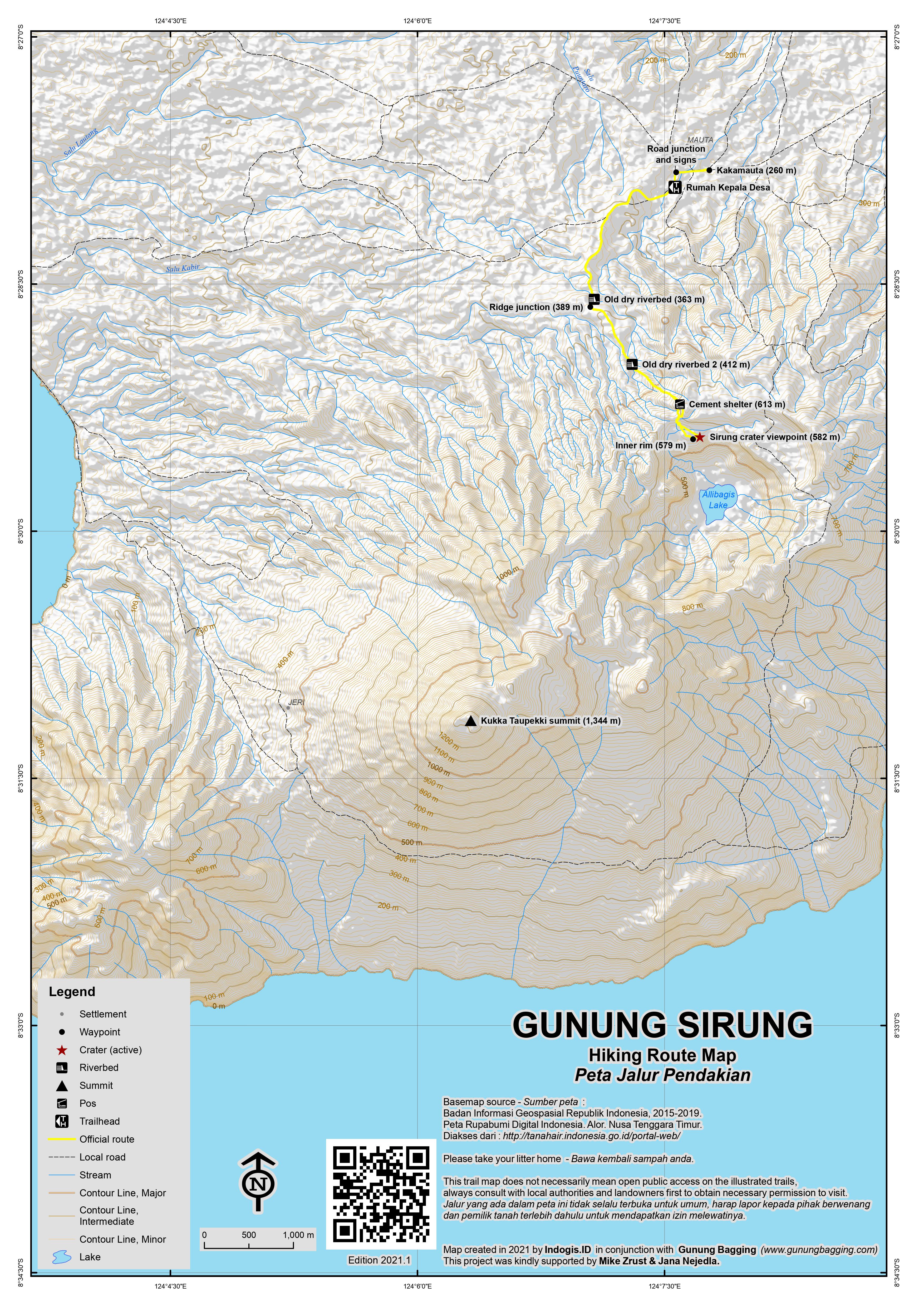
Route from Alikallang (300m) to Sirung crater rim: In 2025, this is the recommended starting point for Sirung crater as it is slightly closer and higher up than Mauta. The trail meets the route up from Mauta at arround 389m as described below.
Route from Mauta (260m) to Sirung crater rim: Most trekkers visit Sirung crater from the village of Kakamauta (260m, 2.5km east of Alikallang, and commonly referred to simply as Mauta) and this can be easily accomplished in half a day as it takes less than two hours to the edge of the crater and around 90 minutes or less back down. Allow more time if you want to descend further onto the crater floor or begin from a different starting point (see below).
It is a very scenic walk but does not go anywhere near the highest part of the range. Note also that the locals say you must not enter the crater from June to September, because, if you did, Mount Sirung could erupt and destroy the cashew harvest. Similarly, you must not go down into the crater from December to April, because at that time of the year it would endanger the rice harvest. So usually you can do the trek in October, November and May only. In reality, this can change depending on recent events so a hike may still be possible, especially if you have checked with a local guide in advance.
Having arrived in Kakamauta, follow the main street through the village, passing the church and the mayor’s office on your left, and the football ground on your right, until you get to a T-junction where the asphalt road leads right. Turn left instead and leave the village on the dirt road leading south-west. A guide can be sought in approximately the fifth house on the left, which is the Rumah Kepala Desa (village head).
There are both advantages and disadvantages to simply turning up, as an advance guide booking by foreigners is likely to be more costly than just asking for someone the same morning, but either way a guide is very much recommended. This is for two reasons. Firstly, the trail is not clear and has no signs. Secondly, it is customary to take a local person from Mauta with you if you are hiking from Mauta. This means that even if you have an experienced local trekker from the main town of Baranusa with you as guide, you may well end up having to pay for a second guide to come too from Mauta. Mauta guides typically cost Rp100,000 for the morning’s hike, but you may have to pay a similar amount towards ‘the village’ and this Rp100,000 fee may be per person rather for your group.
After about 15 minutes, branch off to the left (south, 313m) onto a narrow path leading through high grass. There is no signpost and the beginning of the path is hidden in the grass 1 to 2 metres above the track.
Now follow the trail up to the Sirung crater. The first section will take you through eucalypt savanna. Look out on the right for views to the island of Lembata’s easternmost peak called Ili Uyelewun in the distance. The trail soon drops down into what resembles and old, dry riverbed (363m) before leading up the other side and onto another ridge (389m) where there is a trail leading up from Alikallang. Those with GPS devices might like to make a waypoint here as remembering this vague turning on the way down is not easy!
Continue up the side of the volcano and via a second old, dry riverbed (412m). By this point, the vegetation diminishes owing to the rain of ash that fell on the upper slopes of the volcano during the eruptions of the past decades. Keep walking on the ridge over dark orange and deep red bands of earth. The views back over the north-western part of Pantar are quite spectacular.
The trail gets steeper and rockier and finally a cement shelter (613m) is reached on the outer rim. This would be of great use in the rain, although it is tiny. A pleasant cairn is just a few metres away. Whilst some of the higher peaks in the range which form the south-western wall and highest cliffs of the rim can be seen from here, the full extent of the crater and the lake within it cannot be seen from here. Most hikers will have reached this point in 90 minutes or less from Mauta.
To reach a better crater viewpoint, drop down, via some old half-burnt trees to the inner rim (579m) and a decent spot to sit and contemplate the view (582m). It is around 15 minutes from the cement shelter on the outer rim to the viewpoint on the inner rim and the trail is far from clear.
Inside the crater there is a large sulphurous crater lake and several active steam vents. The lake is called Danau Allibagis, although some locals may say it refers to a second smaller lake higher up somewhere. It is possible to descend onto the crater floor another 150-plus metres below, but you are not allowed to do so all the year round and it obviously requires further time.
Route from Beang Bay to Sirung crater rim: In previous years, some hikers have stayed at residents’ houses at beautiful Beang Bay on the south coast of Pantar. For those who charter small boats it is even possible to directly dock at Beang. Although Beang is further away from the crater than Kakamauta, it may be worth considering if you are arriving by private boat. The hike from Beang up to the crater rim is an easy 4 or 6 hours’, mostly through beautiful eucalypt savanna. From Beang, the best route up leads via via Darang. Starting from Beang, take the trail heading south to the tiny village of Darang (175 metres above sea level, above Tanjung Darangemi on the Bakosurtanal map), where you will arrive after about 45 minutes. In Darang, the houses still have grass-thatched roofs. From Darang, a trail leads up the steep eastern slope of the volcano to the eastern side of the crater rim. Walking time is 3 hours. From where you arrive at the rim, you can head north-west, around the north-eastern side of the crater, to the canyon where the trail from Kakamauta comes up, though this is a considerable circuit.
Bagging information by Dan Quinn (January 2026), with thanks to Walter Denzel and John Hargreaves for input.
Trail Map
For a high quality PDF version of this and other trail maps, please download from our Trail Maps page.
* About 5 kilometres north-west of Gunung Sirung, near Desa Aramaba, you can observe how a new volcano is “born” – the Koralau: on a small, featureless hill, a gas eruption occurred for the first time in February 2011, burned the grass in the surroundings, and created a small crater of only about 10 metres in diameter.
Practicalities
- Getting there: There is a small new airport in Kabir in the northern part of the island, on the west side. From Baranusa it’s nearly 40km up an asphalt road (at least an hour, maybe 2 hours). This little airport sees regional flights, though realistically most visitors are likely to arrive by boat from the neighbouring islands of Alor or Lembata. From the west, take the ferry from Wairiang, Lembata, to Baranusa, Pantar (timetable unknown in 2025 but charters will usually be possible). It is 40 minutes by ojek from Baranusa to Kakamauta. From the east, there is a daily boat at 6am from Kalabahi to Baranusa (6 hours, Rp50,000) which may not leave until well after 7am. A group may prefer to charter a boat from Alor Kecil to Bakalang (1 hour, Rp300,000) or Tamakh (2 hours, considerably more than Rp300,000). Bakalang to Alikallang is around 2-2.5 hours by motorbike and Tamakh to Mauta is around 1 hour. Note there is a modern road between Mauta and Baranusa, should you be staying or travelling that way.
- Guides and GPS Tracks: Want a PDF version for your phone? Looking for a guide? Need GPS tracks and waypoints? Gunung Legiggar and Gunung Sirung information pack can be downloaded here.
- Permits: Not required, although you are strongly advised to take a local guide (from the same village you start in). Delaki is the best for Legiggar, and Alikallang is recommended for Sirung. See notes above on which months are difficult to access the crater from Mauta. Guides typically Rp100,000 for the short trek to the Sirung crater rim, often with a donation to the village added on.
- Water sources: None available on the usual routes. Take enough of your own and don’t expect remote villages to have shops.
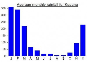
Local Average Monthly Rainfall (mm):
Location
Click on the blue arrow ![]() (top right) to see your current location on the map
(top right) to see your current location on the map
photos of Legiggar ascent – https://web.facebook.com/share/r/17SWzZqz8M/
A day after reaching the summit of Gunung Legiggar, the Pantar island highpoint, I toured the volcano area at Gunung Sirung. The walk up to the viewpoint over the crater and lake is a pleasant and worthwhile morning excursion.
From Delaki, the west coast village which is the base for the hike up Gunung Legiggar, I took an ojek for Rp100,000 along a hilly and bumpy dirt trail up to the hamlet of Alikallang, which is about 3 km west of Mauta, at an altitude close to 300m.
However, there’s no shop in Alikallang. Luckily, my ojek driver agreed to go down to Mauta himself and buy supplies while I waited in Alikallang. The reason he was reluctant to bring me, as I discovered next day, is that the trail remains rough and hilly for a motorbike, with a challenging river crossing.
In Alikallang, I slept at the house of Pak Dan, which is on the main street just below the church and has a sign outside saying ‘PAUD Gunung Sirung Alikallang’.
Pak Dan was also my guide the next morning for the hike up to the crater rim. After recounting the previous evening that we could not go near the crater lest the volcano react to our presence by harming rice crops and other plants, he moderated his stance once we had agreed a Rp100,000 hike fee. We would be able to access the viewpoint via a permitted alternative route, but without descending into the crater. (With rainy season mist drifting in an out, the active crater area is objectively treacherous anyway, irrespective of any occult forces that might be at work.)
After following a path to the right of the village school and past a metal warning sign at 355m, where villagers gather to seek a usable phone signal, we crossed a couple of dry riverbeds. Perhaps the ‘trail leading up from somewhere else’ to a ridge at 389m, described by Dan, is the trail from Alikallang. We ended up at the same cement shelter, reportedly used at one time for storing volcanology equipment.
From there we continued to climb steadily for a further 40 minutes up to 662m, where there is a good viewpoint from the southeast over the lake, though much of the crater rim and the higher tops to the west remained in cloud while we were there.
After a 4-hour walk I returned to Alikallang at about 11.00, grateful to douse myself in cool rain water from the buckets in Pak Dan’s back yard bathroom: at Rp200,000, it was cheaper than a hotel, but just as refreshing!
However, my planned descent by ojek to Baranusa port was delayed by the midday rain shower, which was an almost daily feature of my stay in Alor and Pantar. When we finally set out, we quicky discovered that the river crossing a few hundred meters out of the village was swollen by heavy rainfall and difficult to ford. While I am normally wary of adrenaline-fuelled backcountry ojek riders, I was thankful to Pak Obi, who eventually agreed to ride over while I waded behind, and managed to restart the engine after a few sputtering attempts.
The flip side of his daredevilry was the high speed down the bumpy and muddy trail to Mauta. Once on the asphalt though, we enjoyed a smooth twenty minutes along the almost deserted road to Baranusa.
I stayed in Penginapan Mukhtar near the port; it is good value at Rp70,000, but you must bring your own fan! As Dan reports in his comment, plentiful soakings from the mandi, and shifting to the cooler floor tiles, are helpful strategies to avoid overheating. Late night rain showers cooled the air slightly.
Next morning at 05.30 I was on the dock ready to return to Alor. At first I was afraid that the kapal motor might be cancelled, as it was Christmas Day, and everyone in the large crowd seemed to be waiting for the large Larantuka ferry, which was in port that very morning. Just before 07.00, the small Alor boat appeared and the port staff allowed the dozen or so voyagers to Kalabahi onto the wharf to board and set sail for the Rp50,000, six hour crossing.
I reached the highest point of Pantar Island on a day hike from the village of Delaki.
Boat.
Currently there is a daily boat to Baranusa, the main port on Pantar, from Kalabahi on Alor. Unfortunately, my arrival in Pantar was delayed by a day when I arrived too late at the harbour in Kalabahi. I had been told by three separate sources that the boat would leave at 08.00, only to find on arrival at the wharf that it had already left and that I should come back next morning at 06.00.
At the second attempt, I boarded successfully well before 06.00 and the wooden motor boat eventually left port at about 07.30 for the scenic 6-hour (Rp50,000) crossing to Baranusa. (If a crowded wooden boat with no seats, no standing room and an enclosed hole at the back for a toilet does not appeal, you could wait for the multi-deck steel ferry Sabuk Nusantara, operated by PT. Pelayaran Wirayuda Maritim, but its schedule seems to be in constant flux.)
Ojek.
Pantar has few stretched of asphalt road, including the longest one from Baranusa to Kabir, and a side road to Mauta. But except for pick up trucks in baranusa itself, one sees hardly any 4-wheeled vehicles. Most villages are reached by motorbike along narrow dirt tracks, or by boat.
I scouted an ojek from the jetty in Baranusa to Delaki for Rp200,000. After lunch at what seems to be Baranusa’s only warung makan, and then a false start brought to a halt by heavy rain, we set out along the excellent asphalt road. However, we turned off the road after 30 seconds and were soon dodging overhanging branches, and slithering muddily on the narrow and hilly dirt bike trails that would take us to the west coast.
An hour later, we reached Puntaru, and visited the ‘juru kunci’ of the volcano, who occupies a small house opposite the large and well-constructed, but padlocked, Badan Geologi building. I donated a Rp50,000 security fee in lieu of the pungent, hand-rolled cigarettes locally favoured as gifts. The juru kunci assured us that Delaki was indeed the right starting point to the island high point, and added that local students camped there annually to plant the merah putih flag on Independence Day.
Preparation.
After a further 15 minutes down the broad coastal track through Koliabang, we reached Delaki by 16.00, and were directed to the house of the Delaki assistant village head. We conversed at length over a cup of tea, I trying to judge whether the Gunung Legiggar being mentioned was really the island’s summit, or just some other point convenient for planting flags on Hari Merdeka, while he sized up whether and how he wanted to or could help me reach my goal.
Eventually, I was offered lodging at the house of Pak Jacob, a retired school teacher, escorted to the village shop to buy biscuits, noodles and aqua, and set up with a guide called Pak Krinius. The Rp400,000 hiking fee that we settled on seemed expensive for a single day hike, but acceptable given that reaching the Pantar high point was a rare prize, and that the villagers were going out of their way to attend to me. Indeed, my setting up of a camping stove on the living room floor and cooking of indomie with accompanying condiments proved to have great theatrical appeal, drawing a large crowd of onlookers of all ages.
Ascent.
At 05.00 I set off together with Krinius and his son Mario, strolling along the concrete coast road south of Delaki for the first 30 minutes. There were great views in the dawn light toward both Gunung Legiggar, our target, and Gunung Bemali, as Krinius called it, at the island’s southwestern tip.
(Villagers at Alikallang the next day, however, called the southwestern mountain ‘Gunung Delaki’, and also referred to the village of Delaki itself as ‘Alimaki’. The profusion of names is understandable, since the island has half a dozen distinct languages, all with various dialects. Most of them are called ‘Papuan-type’, although this really only means that they are unrelated to Austronesian languages, such as Indonesian, rather than that they are similar to any languages spoken in Papua itself.)
After leaving the coast, the concrete road alternates with narrower dirt stretches through guava orchards and corn plantations. At about 150m altitude, there’s a fork where the right trail heads off to Gunung Delaki/Bemali. Whatever one calls that mountain, it looks interesting to climb. Krinius said that there are hunting trails all the way up. Based on my reading of Google Maps, the summit is at between 860 and 880 meters, and the col to Gunung Legiggar is between 420 and 440 meters, giving it a prominence of about 440 meters.
Our route followed the left fork toward Gunung Legiggar. At 400m altitude there is a junction where you turn left and the trail becomes noticeably steeper. This would be the last point that could possibly be reached by ojek, though personally I would not want to ride an ojek at all beyond the initial coastal strip. After two hours of walking, we rested at a farmer’s fly-infested shelter at about 520m, followed by a second shack a little higher up.
At about 650m, one leaves the last traces of the shifting rice cultivation practiced by local farmers. The forest thins, and the route soon emerges onto a broad slope covered with grass and eucalyptus forest. We had light cloud cover; without it, the trees would provide only scattered shade from the sun, making sunscreen essential. Hints of a trail appear and then disappear, but the ascent is steady, with solid footing and no need for hands.
There are excellent views back over the west coast villages, the hills on the north west peninsula, and even to Lembata if the cloud lifts.
After nearly five hours walking, we passed to the right of a false summit at about 1290m, and emerged onto a ridge. We turned left and followed the ridge around for about 5 minutes before the final kick up to the summit itself.
At the top there are three wooden crosses; the large central one is adorned with a red and white sign saying ‘Gn. Legiggar #Delaki’. The Legiggar name is certainly used in Delaki, and also on Google maps; perhaps the Kukka Taupeki name is used in one of the other local languages. GPS altitude was 1342m. Clouds blocked the views in most directions, but we could at least identify the crater area about five kilometers northeast.
Descent.
After snacks, photos and rest, I was looking forward to a pleasant return to Delaki down the same route, when I was affected by one of those ‘thought-provoking incidents’ alluded to by Dan. Our guide Krinius mysteriously decided to hare off down an ‘alternative’ route on the mountain’s steep north slope, highly ambitious given that the ‘customary’ trail had been hardly visible in most sections. To reassure me that the new route was good he bellowed to a distant farmer, who bellowed back from several kilometers below us.
We ended up crossing a dry river bed before entering a thick, trackless forest, and then dense meadows of untrodden elephant grass, where I tripped and floundered toward the lower slopes in a worsening rainstorm. After three hours of this self-inflicted battle against the flora, we had descended to about 500m, where we finally met a farming couple at a recently-built shed. They planned to clear the meadow using herbicide, then plant the staple crops of rice and corn.
Descending the gentler lower slopes of the mountain, we joined up with our ascent route at about 250m, just as my water ran out. (I had forgotten that one should always double the water ration when hiking from at or near sea level.) We returned to Delaki at about 15.30, with the 5 hours descent time matching the 5 hours needed for ascent.
Transfer to Sirung.
After paying the guide, and also Pak Jacob for his hospitable accommodation, I requested an ojek to Mauta in order to see Danau Allibagis, the Sirung volcanic lake, the next day. The villagers, though, advised me to go only as far as Alikallang, which is at a higher elevation (290m) and closer to the volcano. Accordingly, I took a 40 minute ride up to Alikallang for Rp100,000.
Conclusion.
The hike to the top of Pantar was very rewarding: rarely climbed, far off the beaten track, with very friendly, though also needy, villagers. Walking up the mountain is a lesser challenge than finding a willing and suitable guide. Getting to Delaki, which is clearly the best starting point, is straightforward, but patience and good Indonesian speaking skills will be vital to ensuring that the preparation in the village and the hike itself go smoothly.
I had hoped to hike up to the true summit of Sirung, and indeed the highest point of Pantar island, last week, but it didn’t happen for 2 reasons. The plan was to hike from somewhere near Desa Delaki, with a local chap who claimed to have done it before.
I arrived on a boat charter from Wairiang (East Lembata). This is not cheap at 1.5jt for a slow 3 hour journey, and nor was it comfortable, the boat being filled with junk that I could barely get over onto the only little flat bit of surface to rest on that was protected from the hot sun. Wairiang pier is also a real mess with the infrastructure being of no use to actually getting onto or off a vessel – so you need to ignore it entirely, roll your trousers up and squelch across slippery mud into the water and pull yourself up onto the boat.
Upon arrival at Baranusa I check in at the penginapan, but was rather concerned to find no fan available – it seemed the only fans were being used by other guests. Feeling quite under the weather already, this presented a real problem, with the room being so hot without any decent ventilation that I had to go to the mandi every 10 minutes and pour some cold water over my head to keep me from boiling up. The room itself was far hotter than outside at the front or in the bathroom – a massive design flaw of some sort. I had hoped this would improve as the evening drew on, but it didn’t, and someone in the neighbourhood starting playing some very loud, thudding disco music.
I was pouring bottled water onto my head as I lay down on the bed, then I would lie on the floor (the tiles providing some temporary relative cool) and then a third position near the open window, hoping for a breeze that never came. This circuit continued all night, but the disco music did stop at midnight. I had needed a decent sleep in preparation for Sirung true summit, but had had quite the opposite. When my alarm went off at 0430, ready to depart at 5am with the guide, I tried to rouse myself but decided it would be dangerous in this state to try to do any hiking – heat exhaustion and so on are very serious issues if you are not in good shape.
So my plan was to give the guide the arranged fee and apologize. Weirdly, he never showed up! Very, very odd. The other guests checked out and I dragged a fan into my room! I then realised that despite also having a plan to hike Gn Tuntuli, I would not be able to do much more hiking until I had recovered properly, so I ought to get to Alor as soon as possible and head home early. Pantar is almost impossible to recover on, with almost unfathomably limited food and limited accommodation. An ojek all the way to Bakalang was arranged – 350k sounds expensive but for the journey it’s about right really. Good driver, peculiar looking bike like it was from some alternate dimension, to be utilised by a cyberpunk. From Bakalang I had a boat chartered over to Alor Kecil within minutes for the standard 300k. I then got my antigen, got a rest and headed home. I’m still not back to normal yet – not really sure what the cause was but if you are not in good shape and full of energy then don’t risk making matters worse, even dangerously so, on the hot, challenging terrain of remote NTT mountains.
I was a bit apprehensive about Gunung Sirung after my previous attempt 8 years or so ago when we were surrounded by stern villagers chomping on sirih / betel and talking about how if we did our hike the cashew nut crops would fail. Nuts are indeed important on Pantar – even the simple kacang tanah here are good quality.
Anyway, it went fine in the end this time, but as seems to be the case with Pantar things take quite a lot of time to plan, and often the planning was a total waste of time anyway. Plus one person will say one thing and another the exact opposite, or even the same person say opposite things within 5 minutes. It can be a hard place to find facts about something until you have actually done that something!
Just getting a motorbike to hire for 2 days was tricky. In Alor nobody would do it, either because we were foreign or because it was a different island or because the eastern end of Pantar was hit so badly by the storm in early April that the roads are like rocky beaches in several places. Or because of all three of those things.
We ended up just getting a boat over to Bakalang, the shortest crossing to make from Alor to Pantar. Rp300,000 – quite reasonable. Once in Bakalang we found a losmen, the cheapest I have ever stayed at, just Rp50,000 a night. But very simple… no bed as such, just a room. Literally. A floor, some walls, a roof and a door. But a plug for charging your phone and friendly owners and great views over to Pulau Pura. At first they looked at us as if they had seen an apparition, but we reserved rooms for the next night.
Continuing past the incongruously huge new Bakalang ferry terminal we asked folk about hiring a motorbike. We kept on being told to try another 50 metres down the road until one guy offered his ojek air, or water taxi. But ideally we needed wheels of our own for getting round this island and back again. Finally someone agreed, a chap originally from East Java. But Rp400,000 for 2 days – expensive. Perhaps fair enough given that we were taking it through a natural disaster zone and back again the following day.
The road was extreme. Pantar’s roads were extreme even before Seroja struck. Now they are very challenging on the southern coast. But at least they seem to be being rebuilt in sections. Some sections are unscathed and others utterly turned to rubble. In one spot there was a collection of large tents for those displaced by the disaster. It was quite bizarre riding through and must have been horrific at the time. But all this is juxtaposed with some of the most glorious coastal scenery in Nusa Tenggara.
Once up above Tamakh things improved although the Google Maps information is useless from this point on. They haven’t got a man on the ground on Pantar, that’s for certain. Once section of good road is completely missing and it then sent us via Puntaru on the west coast when we should have turned at Mauta and followed a brand new asphalt road straight to Baranusa. It took us 2 hours from Mauta instead of 40 minutes. Thanks Google. And the road turned into a river crossing and narrow track at one point, barely passable. At each junction we hoped the next turn would be onto something resembling a road instead of the surface of the moon, but it remained diabolical until we joined the new road just one kilometre from our Baranusa losmen!
All in all, it took us 4 hours from bakalang to Baranusa but we could have done it in under 3 if we had turned at Kakamauta. Mukhtar losmen is the same place me and Nick stayed 8 years ago but possibly with a new name. Rp60,000 each room now, still very much a good deal and friendly owners.
Quite typically, chats with possible guides for Sirung were getting more and more confusing. A few days previously a Mauta chap had said he could get us a guide for the true peak where locals go hunting. We agreed a price. But when the date was confirmed he said everyone was busy with the rice harvest. I said I’d look for someone else. Finally found a Baranusa resident who had never been to the true highest peak but was very keen and obviously understood what we meant.
We arranged to meet at 7pm at the losmen to discuss the following day but then he never showed up. Meanwhile the Mauta contact sent me a message saying the youths of the village had noticed some bules driving through the village today. Perhaps they really don’t have anything better to do. Anyway, more importantly he said if you want to hike from Mauta you must take a guide from Mauta. I had feared such a thing might be a problem in Kakamauta. So I told our Baranusa guy we wouldn’t be able to do it with him. Then I asked the Mauta guy if he was going to be our guide or who it would be. He told us not him, and to message upon arrival. I told him 0630.
The next morning we set off before sunrise up the lovely new asphalt road to Mauta which we had completely missed the day before! No signs though, so we did end up doing a 3 or 4km along a dirt track instead of the proper road at one point.
Up at Mauta, quite typically, no answer from the contact there, so we just asked for the Kepala Desa instead. My mate nearly crashed the bike into a bush and wall, sending one old resident to almost run for his life after seeing this Dutch ghost cause such havoc at 6am!
At the Kepala Desa’s we were nodded in and stared at before a friendly guy called Marcus led us up to the crater, with the highest peak sounding like it would be much better approached from the west near Desa Delaki, as previously thought. Great hike anyway, detailed above.
Whereas in many villages, including the one at the foot of the previous trek Koyakoya on Alor, if you arrive back to a village house with plastic chairs then it usually means a feed and an opportunity to chat with the locals. Not here. I guess the chairs were for someone else entirely and when we got our bag and left, as foreigners actually really want to do many times rather than be asked the same question for the umpteenth time and almost held against their will, it was no problem at all and perhaps even hoped for. I think the Mauta folk had bigger things to do that morning than chat with a couple of white folk.
We were back at Bakalang earlier than expected and it turned out that our informal bike hire guy had been in prison in Australia for over a year several years back. A snakehead transporting ‘illegals’ from Bangaladesh etc over to Australia!
At one shop I asked what time they closed and was told that it’s 24 hours but it closes at 8pm. Only on Pantar! Great telkomsel phone internet at this end of the island, really impressive. Indeed there’s a luxury resort another 10km further up towards the tip and another foreigner has supposedly just put down some money on a lease to do something here. We had a red supermoon in the evening over Pulau Pura. Beautiful.
The next day it was back over to Alor and some local sopi (red, Rp30,000 meaning medium quality, for a small Aqua bottle). Very pleasant. And the end of a fabulous trip. Hopefully I’ll be back later this year for Tuntuli, Taupekki and maybe even the true peak of Pulau Pura from a different approach.
Always wanting to climb Mt. Sirung via Kaka Mauta, on my first attempt in July 2018, I was denied access supposedly because of the cashew nut flowering season in full force. However, a year later, on August 4, 2019, my friends and I rented motorbikes in Alor Kecil, chartered a boat and went to Pantar Island. Aware of the cashew nut flowering season, we opted to attempt the climb from Darang, about an hour-long hike from Beang, which we could reach on our motorbikes.
The first part of our adventure involved a nice 45 minute boat ride from Alor Kecil to Bakalang. From there we took our motorbikes on the narrow road to Beang – here and there it was quite rough, especially with 2 people on the motorbike. The only place to have lunch is at Tamakh which we reached after 4 hours of bumpy ride from Bakalang.
Once at Beang, we stayed for two nights at Pak Rehabeam/Ibu Agustina’s big house by the beach. The house features 5 bedrooms and the host served us three meals. Drinking water is boiled rain water. Bottled water is hard to find.
A guide named Nixon came with us to Darang, our planned starting point for the hike up Mt. Sirung. The one-hour hike from Beang to Darang is beautiful albeit somewhat strenuous first thing in the morning. We later learned that there’s actually a direct path from Beang to Mt. Sirung. This avoids paying a permit fee and therefore Beang is a good choice and nobody will stop you to climb from Beang at anytime. Our guide Nixon knows the way. In Darang, we paid IDR100k (USD8) per person including an additional guide’s fee. The Village Head will tell you it is not OK to climb during the cashew nut flowering seasons, but after some negotiations and the aforementioned fees, everything was fine.
The hike from Darang to the edge of the crater took close to 4 hours. I am sure it is possible to hike down to the crater, but this requires a very early start and would be best to do from Beang to save the two-hour roundtrip hike to Darang. It goes without saying that one must bring plenty of water and food.
After all the hiking, fantastic water wells in Beang welcomed our tired bodies. The water has various temperatures, ranging from cold to hot. Bring a mini inflated pool with you to have a nice soak after the hike.
We brought motorbikes to Pantar Island since it’s difficult to arrange to rent motorbike in Bakalang; Ojeks are available but then there is less freedom. A small truck is possible to hire, but would be a challenge to ride in.
There is a daily ferry from Bakalang to Alor Kecil. The ferry arrives Alor Kecil around 8 AM, drops off passengers then continues its way to Kalabahi to pick up supplies then back to Alor Kecil to pick up passengers and departs around 11 AM.
A video of our trip is on youtube: https://youtu.be/2H0TLzSdOrY
Geonames shows “Kukka Taupekki” for this highest peak at -8.5188 (S), 124.10523 (E), with height 1312m; pretty close! http://www.geonames.org/8422944/kukka-taupekki.html
Mt Delaki is listed as S 8° 31′ 59” E 124° 4′ 16” (https://goo.gl/maps/xvnrbwf13e92), which fits the 880m located 4km WSW of the highest peak of Sirung, according to GeoNames (http://www.geonames.org/advanced-search.html?q=delaki&country=ID&featureClass=T&continentCode=). Also, S 8° 33′ 1” E 124° 3′ 51” is “Tajung Delaki”, or Cape Delaki, the southwest tip of the island, just below that other peak.
So I think Gunung Delaki is a different peak.
That still leave the question of the correct name for the highest peak near the volcanic vent!
Did this last week, a bit of a mixed bad really. Left from Baranusa, ojek to Mauta, where after meeking with headman they decided had to pay 100k for a “guide” and 100k to the village – non-negotiable.
Ok start walking, about 1.5 hours in reach a clear split in trail where there is a rocky pass into the crater and another up to the rim. Here the guide demanded another 100k to go to either rim or crater. When I refused he started walking back!
I caved and said ok, lets do the crater, go in and it is suitably impressive. When we come back out, he wants **another** 100k to hit rim and I tell him to forget it and we walk out.
Is a relatively easy walk in and out, but very oridinary experience with the guide.
Hi Dan,
I wish I had known you were in Alor/Pantar in July. I was there too. It seems that the people of Kakamauta are overdoing things now – the idea that visiting the volcano will damage the cashew harvest. This may be due to the eruption of May 2012, although it was a small one. I last went up to the crater in August 2012 – via Beang and Darang. The mountain was still closed by order of the authorities. My guide was Pak Zabdi from Beang. He belongs to the tribe (suku) who owns the land, and he is an important person in his village. He said that no one would ever prevent him from setting foot on his own land and took me up to the crater (see photos and video). So I do recommend to take the route from Beang via Darang, or straight up from Beang (there is a path too), avoiding Kakamauta. Poor Feri Tai :)- I met him again in 2012 – he had come all the way to Koliabang to meet me.
I recommend you go to Beang from Hirang Village on Alor. BTW, they have built a jetty now in Beang Bay. In Hirang you can enjoy the beautiful white sandy beach, Serani Beach. Check it all out on
http://hirang.webs.com/apps/photos/
Best,
Walter
PS: Dan, I hope you’ll come to Alor again next July/August. I’ll be there, and I’ll try my best to make up for the rather unsatisfying experience you had this year.
Hi Walter. Great to hear from you – I was a little worried you might have been sacrificed to the cashew gods! Next year would be great – I hope I can find the time for another NTT trip. Cheers for now, Dan.
After coming down of Pura, we continued by boat towards Gunung Sirung on Pantar island. It took about 2 hours by slow boat to reach the tiny bay of Tamakh on the south coast. The trip, assuming your boatman does as ours did and hugs the coast the entire way, passes some lovely black rock formations and remote villages. Indeed, Pantar must be one of the most remote islands in Indonesia, with no proper roads, just dirt tracks, and clearly very little government money gets this far.
Our arrival caused quite a commotion, with local chancers taking our bags and loading them onto motorbikes before we had even agreed to anything. Initially they wanted 75,000 for each ojek to Kakamauta, the village at the base of Sirung. Even given the recent fuel price increase, this is quite a sum for a one hour journey along a track. We managed to bargain them down to 65,000 each and off we went. The track leads steeply inland up the mountain and in places there are some lovely views of the Sirung mountain range.
On our arrival in Kakamauta, we were surrounded by friendly but frazzled local chaps who had been chewing away on the betel nut all day. I mentioned climbing the mountain and looking for Feri Tai, the chap who had guided Walter up there the year before. Immediately they got very defensive and pointed to a nearby cashnew nut tree.
“Our cashew nut harvest is not good, and if you climb this mountain, the harvest will fail and there will be many victims, not only in this village. We will not stop you, but there will be many victims”.
Not exactly the sort of greeting we were hoping for. We decided to head to the house of the Kepala Desa to see if we could get any common sense out of anyone. Once again, a large crowd gathered, men asking for cigarettes, and nobody seemed to say anything of any sense. There was obviously a tension between the ancient belief of the link between climbing the volcano and having crop failure and the possibility of making some money by guiding us tourists up the mountain.
As Walter wrote above, certain months of the year you are not allowed to descend into the crater, but it seems this has now been extended to climbing at all, regardless of whether you want to enter the crater itself. Perhaps there is a link between sulphur and poor harvests. But to warn people against climbing the volcano at all is really only going to have the effect of keeping Pantar in a medieval state with virtually zero tourist money coming in and an only precariously held state of basic morality.
Given that there was no restaurant, shop and that we both hadn’t found a willing guide and had kind of caused a scene by even asking about the volcano led us to decide to abort and continue to the main port town/village of Baranusa, about 45 minutes and 20km away from Kakamauta. We asked the locals in Kakamauta about ojek prices to Baranusa, should we stay, and the first chancer suggested a whopping Rp200,000! Yes, this was the first part of the bargaining game but I find it offensive really. Take whatever you can, if the foreigners are stupid enough to pay it. No sense of ‘a fair price’.
So we continued with our original ojek boys, who were being bullied a bit by the locals for not passing us on to them, and were glad to be out of there. Bad vibes. Who would want to be sacrificed to the gods of cashew nuts simply for climbing a volcano?
Baranusa must be one of the tiniest port ‘towns’ in Indonesia. Luckily Homestay Burhan had basic rooms for Rp50,000. The public boat on to Wairiang on the east coast of Lembata leaves on Sunday (though these things change) so we had just missed it and without chartering our own vessel, we would be stuck waiting for another week!
First things first, we had to pay the ojek boys for our journey. Nasty little swines they were, demanding Rp200,000 each and refusing to accept my very generous offer of Rp300,000 in total. But, as a foreigner in a very primitive place you have very few options. If we had agreed a price back in Kakamauta it would have been fine, but talk of 200,000 there and our lack of ability to clarify with our own ojek boys (as we were surrounded by villagers) meant we would have to discuss the final price in Baranusa itself.
So, all this the same day as we climbed Pura. Not the best afternoon ever, in all honesty. Fascinating but ridiculous, especially as Sirung is supposed to be a brilliant volcano. Perhaps in another hundred years, the locals may start receiving some basic education, enough to help them realise that climbing a mountain and failure of cashew nut crops are not causally linked. Totally nuts!!!
The electricity came on at 6pm and we got the helper at the homestay to go and find us some beers. Bizarre, microtonal synth strains began emanating from the nearby mosque and we had to watch our heads if we wanted to use the mandi, as there were a few wasps living in the doorway.
After a coffee and a rice and noodles meal next door we fell asleep and dreamed of evil nut gods.
News just in from Walter Denzel: “I’ve made it to the high-point of Mt. Delaki. An update for your page and photos will follow soon.”