
Facts
- Elevation: 1,832 m (6,010 ft)
- Prominence: 1,832 m
- Ribu category:
 Kurang Tinggi
 - Province:
 Nusa Tenggara Timur
 - Island: Alor
- Coordinates: -8.2212, 125.0206
- Rating:

 (1 votes) Add your rating
 Loading...
 - World Ribus ID: 69043
Photos


Bagging It!
Dola Koyakoya is the highest point of Alor island and is the last major peak in the island chain east of Java running all the way from Bali to Timor Leste (East Timor). It is home to a large number of deer and, like many of the highest hills from Lembata island eastwards, the higher slopes are incredibly scenic eucalyptus forest with plenty of distant views and reasonably easy walking.
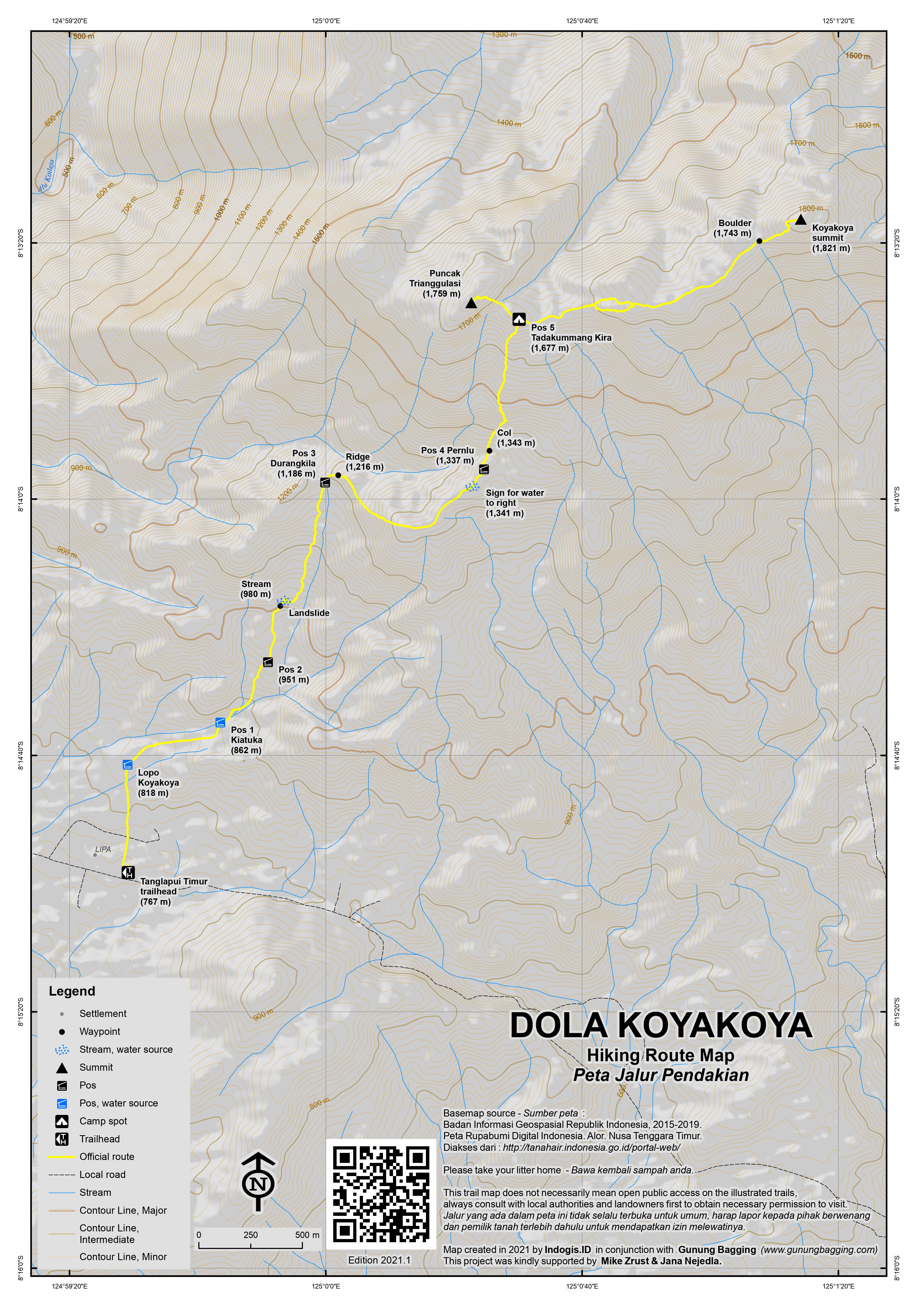
Koyakoya is occasionally climbed, especially on August 17th by local hikers, and the traditional house at the trailhead in Tanglapui Timur has a guestbook and even a second traditional house or ‘lopo’ where hikers may stay a few minutes’ walk above the village and main road. The first time the trail was officially used by hikers was back in 2013. Look out on the main road from Kalabahi for signs for Kaipera and then Desa Kobra before the sign for Marten Modena’s Lopo Koya Koya on the left (767m).
Dola Koyakoya can be hiked in a single day if you set out early enough or stay close to the trailhead, but camping at Pos 5 is a good option too if you want the finest early morning views from the top. Allow around 4-5 hours up to Pos 5 where the trail splits to head towards two different peaks, 2 hours to explore the true summit (or just 1 hour if you prefer a slightly lower, closer and more popular viewpoint) and about 3 hours back down from Pos 5.
From the trailhead, the route follows a village track for a short distance before heading straight on along a narrower path to Lopo Koyakoya (818m). This is the traditional house where hikers can stay in normal times, though at the time of writing in May 2021, the building needs a bit of work after the recent Seroja storm which brought devastation to much of the Nusa Tenggara Timur province.
Behind the lopo, follow the cement water channel before veering left (857m) towards Pos 1 Kiatuka (862m), which is a stream that the trail crosses before entering bamboo forest and undergrowth. Here the sign reminds us to take care of our attitude and behaviour. The next landmark is a water tank (896m) before Pos 2 (952m) which in 2021 is not marked. It is thought to have been an ancestral burial spot. Beyond Pos 2 is a landslide area near a stream (980m) where the new path is steep and not always clear. Take care with route-finding and watch out for spiny plants.
Pos 3 Durangkila (1,186m) marks the beginning of a much better established path up a pleasant but occasionally very steep grassy ridge (1,216m). This is the spot where a sign commands us to ‘keep striving until the sheep become lions’! From here, the views are great back down to the valley where the trail started and also on the left up to the higher slopes of Koyakoya. It is also where you are likely to begin to see deer. The trail levels off for a while and is delightful walking when not in direct sunlight.
There is a sign at 1,341m for a water source on the right of the trail before Pos 4 Pernlu (1,337m) which according to the sign is regarded as a place of shelter. In previous times, this is where locals prepared deer meat after a hunt before descending to the villages. It should have taken you around 3 hours to reach this point. After a minor col, the trail starts to get much steeper and it can occasionally be quite frustrating with tiny stones in the grass making it easy to fall over.
There are a few more signs at this point, including one about edelweiss and another about taking memories home (1,591m). Finally the top of the ridge is reached. This is Pos 5 Tadakummang Kira (1,677m) and is the ideal spot to camp at. According to the sign, this is the war warriors’ treaty place, with local tribes agreeing to cease all fighting. There are a few small cairns here and the scenery is delightful. From here, you can see Puncak Trianggulasi on the left (north-west). You may even be able to see the cement pillar made by villagers at the top. On the Bakosurtanal map this peak is labelled Dola Potomana (1,759m) which is quite accidentally quite an apt name in Indonesian (photo where!) as it is a grand spot from which to take photographs.
From Pos 5 to Puncak Trianggulasi / Potomana is just 20 minutes but it is quite steep so do take care. There are various summit signs here next to the village-made cement pillar and it is clear that most hiking groups aim to get to this point rather than the true summit which is over 1.5km to the east. If you have time for both, our recommendation is to visit this spot first and then go to see out the true highest peak on the other side of Pos 5.
From Pos 5 heading north-east to the true summit of Koyakoya takes around 45 minutes (one way) and in clear weather it is fairly straightforward terrain despite few hikers visiting it. The last section is the hardest, with steep terrain and then a tiny little summit ridge with considerable drops on either side and crowned with cantigi shrubs and a summit sign erected by ‘anak bangsa’. The Bakosurtanal map gives an elevation of 1821m, and our GPS hovered around 1830-1833m. If anyone else gets a similar reading please let us know and we will officially increase the height by a few metres on the site.
A slightly lower peak lying just 500 metres to the south-east of Koyakoya summit is called Dola Doraniki (1,751m). And a further two kilometres to the south-east of Doraniki is a small upland lake called Ireaku Koyakoya, though it is not likely that either of these spots is visited on a regular basis except by deer.
Koyakoya can be seen clearly from Timor Leste’s Atauro island, and indeed from the higher slopes of Koyakoya the mainland of Timor Leste is visible, including the small nation’s highest peak Gunung Ramelau. These high ridges of Alor island are a great place to savour before descending back down to the village by the same route.
If you ask politely, the villagers may show you their traditional moko, an ancient metal drum that most Alor villages have, keep in the roofs of their traditional houses, and are used for dowry purposes. The local belief is that these objects are directly given by nature (‘alam’) but others suggest that they originate overseas from long, long ago. There is a museum in Kalabahi with detailed information and numerous examples.
Bagging information by Dan Quinn (May 2021)
Trail Map
For a high quality PDF version of this and other trail maps, please download from our Trail Maps page.
Practicalities
- Getting there: Fly to Alor’s Mali airport from Kupang, West Timor. Then it’s around 2.5 to 3 hours by road (85km) from the Kalabahi area to Tanglapui Timur trailhead at the top of the main road over to Marataing.
- Guides and GPS Tracks: Want a PDF version for your phone? Looking for a guide? Need GPS tracks and waypoints? Dola Koyakoya information pack can be downloaded here.
- Trip planning assistance: Would you like Gunung Bagging to personally help you in arranging your whole trip? Please contact us here.
- Permits: Register in the trailhead and write your name in the book which has been kept since 2017.
- Water sources: Always available at Pos 1 (862m), and beyond Pos 2 (at around 980m). Usually available off the trail at a sign to ‘sumber air’ on the right (1,341m) and beyond Pos 5 (1,677m) but you may need a local guide for help with this and the sources may not be available higher up in the dry season.
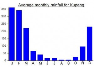
Local Average Monthly Rainfall (mm):
Location
Click on the blue arrow ![]() (top right) to see your current location on the map
(top right) to see your current location on the map
Having previously reached the highpoints of the six largest Lesser Sunda islands (Timor, Sumbawa, Flores, Sumba, Bali and Lombok), I found the challenge of summiting the seventh largest (Alor) irresistible.
After a six hour journey – flying Batik Air from Jakarta to Kupang and Wings Air from Kupang to Mali (airport code ARD) – I touched down in Alor and rode a taxi (Rp75,000, 20 minutes) to the travel car stand near Pasar Lipa (often called Pasar Terbakar) in Kalabahi. From there, I joined an 8-passenger Suzuki minivan (Rp70,000, 3 hours) to Tanglapui, where the driver dropped me off at the large gudang beside the main road.
After asking a passer-by for Pak Marten, I eventually met up with Marten’s son Toni, who led me the 15 minute walk up the farm track to the Lopo Koyakoya farmhouse, where I was able to use the house’s bathroom and camp in the adjacent open shelter. Initially, neither the elderly couple staying in the farmhouse, nor Toni, seemed keen on my plan to hike the mountain in rainy December. One passing visitor discouragingly informed me that I could get the 3 a.m. bemo straight back to Kalabahi if need be.
Fortunately, when Pak Marten himself appeared early next morning, having returned from business, we agreed that Toni would act as guide for a two-day hike, for a fee of Rp200,000 plus a Rp100,000 access charge.
By 07.30 Toni and I were opening the bamboo cattle gates and heading up the mountain.
The hike is still very much as described by Dan above, except that the Pos numbering has changed, confirmed by official-looking metal signs with black letters painted on a yellow background. Kiatuka (862m) is still called Pos 1, but Durangkila (1186m) has now become Pos 2, with Pernlu (1337m) as Pos 3 and Tadakummang Kira (1677m) as Pos 4. There’s also a yellow arrow sign for the water source shortly before Pos 3, while other landmarks mentioned by Dan, such as the water tank and edelweiss sign are still in place.
The ‘landslide area’ mentioned by Dan at about 1000m remains messy, with an indistinct trail through tall elephant grass where it’s easy to trip over. After this, the trail is well-defined. We reached our intended campsite at Pos 4 in three and a half hours. There are more black and yellow arrow signs there, with ‘Puncak Koya Koya (1759m)’ and ‘Puncak Longsor (1736m)’ to the left. The signs for ‘Puncak Sejati Kunggilomang (1832m)’ and ‘Danau Mirayaka’ point to the right.
After setting up our tent and sitting out a rainstorm, we thought it best to head straight up to the Puncak Sejati, which took about an hour. There are further yellow arrow signs, with Puncak Sejati left and Danau Mirayaka right, at about 1780m, just before a steep, crumbly soil section up to a ridge. We made a mistake here by bearing right a couple of hundred meters along the ridge, instead of veering back left, which turned out to be the proper summit path.
After correcting course, we reached the stone summit block at 14.00. My GPS registered 1825m, lower than the 1832m engraved on the sign. Views were limited, with mist shrouding the mountain on all sides.
Back at the campsite an hour later, we sheltered from another rainstorm, somewhat unsuccessfully. The pummeling rain defeated our tent, which started taking in water. Rather than risk an icy night-time soaking, we abandoned our plan for a sunrise photo shoot at the Koyakoya viewpoint, broke camp and headed straight back down the mountain, with 2 hours daylight remaining.
This left us to complete a difficult last hour of the descent by flashlight, through the entangling elephant grass, and obstructed by a snake wrapped in the bushes at the very point where we wanted to cross the river just below Pos 1. After trying in vain to get it to move by poking it with his long stick, Toni finally immobilized it with some well-aimed blows to the head.
Teetering along the cement water channel in the dark convinced me that Dan is right to warn in his comment against night hiking on the lower section. I was concentrating so hard that I thought I would be hallucinating narrow cement ledges in my dreams.
At about 19.30, we reached the Lopo base camp, with a warm, smoky fire, dishwashing water, and pleasantly ventilated bamboo shelter.
Next morning at 03.00, I packed up in the dark, and walked down to the main road with Toni for the early morning bemo to Kalabahi market. At about 04.00 it roared in, rainbow lights looming out of the darkness, blaring horn shattering the silence and East Indonesian pop beats thumping through the mist. Surprisingly, it cost Rp100,000: poor value compared to the travel car, with a lot more off-piste diversions to pick up farmers heading to Pasar Kadelang vegetable market. And the journey took 4 hours to Kalabahi, plus an extra 45 minutes when the brakes failed just 3 km short of the town centre, necessitating a roadside repair stop.
In Kalabahi, I can recommend the Tamala Homestay as a well-kept small hotel. Perfecto Café is a comfortable restaurant with good nasi campur, RM Jember has tasty Javanese food, and Mama’s Restaurant has a great location with fresh fish and views over the bay.
Chartering a boat to see the friendly dugong offshore from the airport is a not-to-be-missed experience – if the dugong is still there when you visit of course!
For Koyakoya, the best advice is probably to go in the dry season, when skies are clear and camping is pleasant. In the rainy season, better to focus on just getting up and down to bag the summit in among the rain showers.
ascent of Dola Koyakoya photos –
https://www.facebook.com/john.hargreaves.520125/posts/pfbid0n14Nns1uAEPSUSq44LUX6MfpxEDSpCCGHPNVdyX3795QE7duRkPTh9fu7iVUQ17Rl
Petter B climbed Koyakoya this week and got a GPS reading of as high as 1838m and noted a new cement summit sign with 1832m on it and Puncak Sejati Kunggilomang (true summit Kunggilomang). Perhaps Kunggilomang is the local name fo the true peak. Google brings up nothing on the word. Anyway, given my earlier GPS readings of 1830-33m, 1832m sounds about right. The current 1821m figure will be updated accordingly….
Had a fantastic trip to Alor and Pantar last week. The whole thing was quite uncertain due to the horrendous destruction wrought on the islands by the Seroja storm. Indeed we met one chap on Pantar who said he had to start again from zero. But the main roads are at least passable on both islands now. Over in Kupang there are one or two brand new ‘lakes’ created by the sheer power of the storm. Perhaps storm is wrong word.
The road out of Kalabahi up into the hills in the east is incredibly scenic, followng the coastline for a fair distance. Google reckoned just over 2 hours but it was closer to 3 by the time we got the village.
The Lopo Koya Koya sign at the side of the road was still toppled over, perhaps since the storm. We got started fairly quickly, having arrived a bit late in the afternoon, and still hoping to reach Pos 5 and camp there. Well, we made it, with a more-or-less full moon to help us part of the way. The lower sections of trail have been affected by landslides from the storm in early April and you wouldn’t want to do those in the dark at present. The darkness may have been a blessing beyond Pos 3 where the ridge gets steeper. We could see the lights of East Timor in the distance.
In this area you often hear gongs being struck down in the villages, typically on the hour when there is a meeting or some kind of traditional task that needs taking care of. It was quite beautiful. For hikers, upon hearing these gong beats you are supposed to take a short break. We were quite happy to do that on the final slog up to Pos 5. We didn’t get a good look at the deer, but saw plenty of their eyes in the dark and heard them. Apparently as of early 2021 there are new restrictions on hunting them.
A bit of low cloud or mist up there, with the full moon. Stunning. Reminded me of Lembata’s Ili Uyelewun. I can see why some locals think the place is haunted but we slept pretty well.
At 5am we were up and quickly on our way to Puncak Trianggulasi for what the guides claimed were the best views.
Indeed it is very pleasant indeed. But we didn’t wait around too long at the cement pillar as we were more interested in the true summit that very few people bother with. Lots of green and yellow cockatoos flying about near Pos 5.
It was a lovely 45-50min stroll over there in the early morning sunshine and then back again and down and a look at the village moko, or at least one of them.
Back down in Kalabahi we checked in at the Mokkolipa Guesthouse – a new place, well-designed and has everything you need. Perfect and reasonable price. Recommended. But for views at sunset and some culinary treats, walk over to the rooftop bar and café at Hotel Symfony. In clear weather you can see Pulau Pura and even Gunung Sirung in the distance.
Pingback: Dola Koyakoya: Hiking the Haunted Mountain of Alor Island - Quit and Go Travel