
Facts
- Elevation: 2,329 m (7,631 ft)
- Prominence: 694 m
- Peak category:
 Spesial
 - Province:
 Nusa Tenggara Barat
 - Island: Lombok
- Coordinates: -8.4191, 116.5714
- Rating:


 (4 votes) Add your rating
 Loading...
 - Other names: ‘Montongkeliun’ on the Bakosurtanal map
Photos


Bagging It!
Given their close proximity to the huge Gunung Rinjani, the grassy mountains to the east of Sembalun are easy to overlook. However, these pleasant ridges provide some outstanding views to both Rinjani and eastwards to the ocean and the island of Sumbawa and are well worth a hike in their own right.
Gunung Sempana (‘Montongkeliun, 2,326m’ on the Bakosurtanal map) is the highest and for that reason arguably the finest viewpoint. Just a few years ago, nobody had heard of this and only the lower Pergasingan Hill was trekked by those looking for something much easier and shorter than Rinjani. But in 2021, Sempana is a popular camp spot with locals on weekends and what a fabulous viewpoint it is in the early morning.
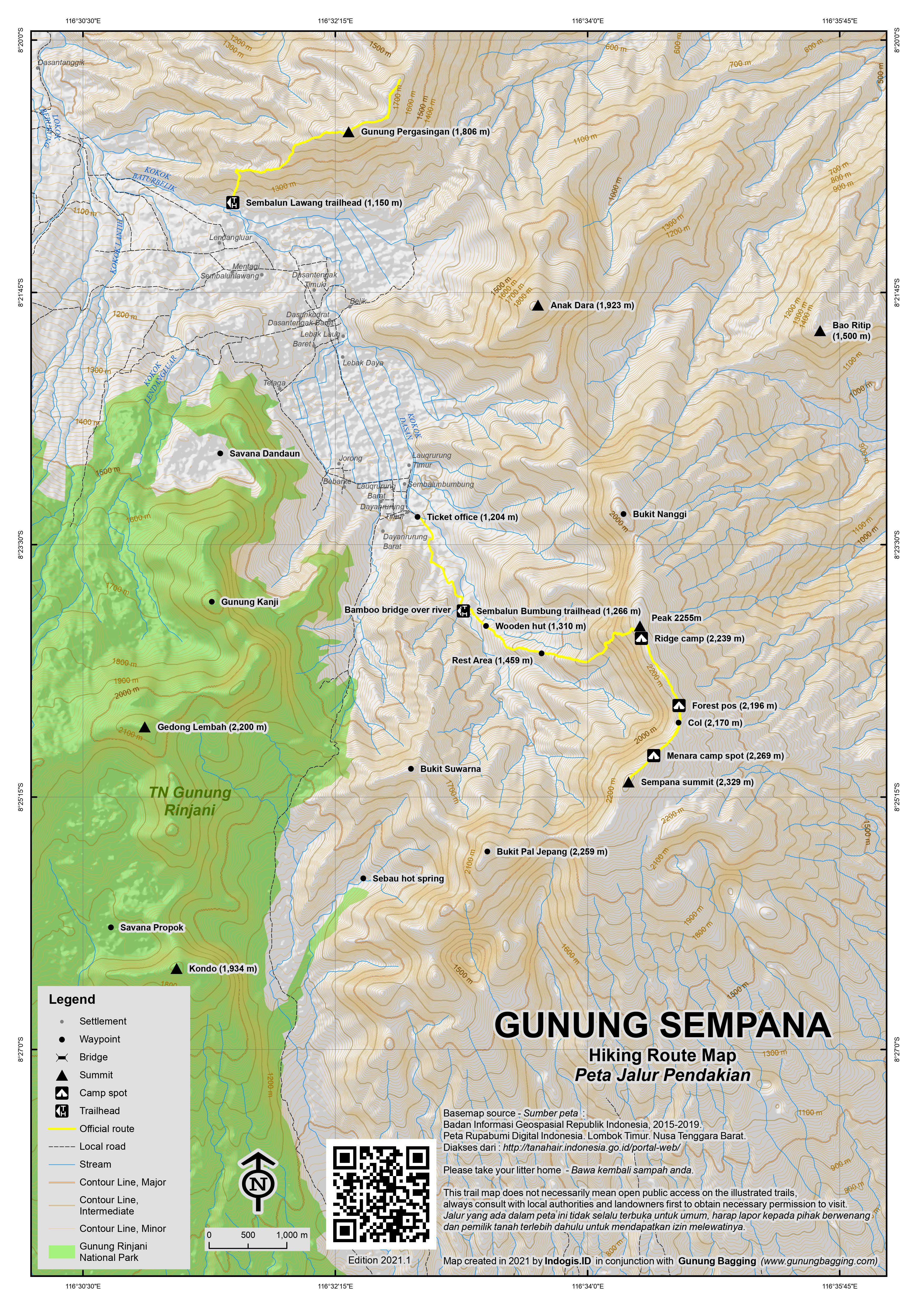
From Sembalun Bumbung (south of Sembalun Lawang where the Rinjani trailhead is), a farm track leads from the simple wooden ticket office and warung (1,204m) into the heart of the hills. You can take your bike or go with a guide to save perhaps 30 minutes of walking. A small parking area (1,266m) and sign pointing across a bamboo bridge mark the formal trailhead.
The trail then leads through farmland, past a wooden hut (1,310m) before entering forest. There is a pleasant rest area (1,459m) before the trail emerges from the forest (1,502m) and onto a grassy ridge that gets steeper and steeper as the path zig-zags up the mountainside. At one point there are some simple wooden steps to help you (1,888m).
After a total of less than 3 hours you will be up on the ridge, which has some lovely cemara trees on it and is a popular spot for camping (2,239m). On the other side of the Sembalun valley is, of course, Rinjani itself, framed beautifully by the cemara trees. If you head to the left (north) for just two minutes, you will reach the highest point of the ridge here (labelled Atas Timuk, 2,255m on the Bakosurtanal map but not popularly known by that name). Over to the east is the coastline and two flat islands Gili Lawang and Gili Sulat. Further east is Sumbawa, and you may be lucky enough to see Gunung Tambora in the distance.
Those wanting to reach the true summit of Gunung Sempana have another 40 minutes or so of hiking ahead of them, following the ridge southwards via some more good camping spots and then a little bit of forest (2,196m) before the col (2,170m). The trail then rises up past a transmitter of some sort (2,269m) which is another popular camp spot before reaching the true summit of Sempana and the highest top of all of these eastern hills.
To descend to the trailhead takes less time, so the entire hike can be accomplished in 6 hours or so by most.
Gunung Sempana is also one of the ‘Seven Summits of Sembalun’, a list created recently that includes Rinjani, Sempana and five other tops to the east of Rinjani. There is a challenge to reach all seven peaks in the shortest time possible, and at least one runner has done it in under 24 hours though most teams require 4 days!
The other five on the list are Gedong Lembah, 2,200m (‘G. Lembah, 2,194m’ on the Bakosurtanal map), Kondo, 1,934m (‘G. Seribu, 1,934m’ on the Bakosurtanal map), Anak Dara, 1,923m (‘G. Dara, 1,921m’ on the Bakosurtanal map), Pergasingan, 1,806m (‘G. Pegasingan, 1,793m’ on the Bakosurtanal map) and Bao Ritip, 1,500m (‘G. Sengkor, 1,495m’ on the Bakosurtanal map). Quite why some of the names on the Bakosurtanal map seem to have been updated or ignored or were simply wrong at the time the map was made is not clear, but Bakosurtanal are usually very accurate so perhaps some of these new names have simply been invented recently!
Indeed, there are several others peaks in the area, namely Bukit Nanggi (G. Iyasa, 2,039m on the Bakosurtanal map) which lies south of the Sempana ridge. Bukit Suwarna (G. Adas, 1,899m on the Bakosurtanal map) and Bukit Pal Jepang (G. Tanakiabang, 2,259m on the Bakosurtanal map) are between Sempana summit and the highest point of the road running north-south between the mountains (known as Pusuk Sembalun and roughly 1,635 metres above sea level).
To the west of the road, on the Rinjani side, Gunung Kanji (2,065m) lies north of Gedong Lembah and south of the popular Savana Dandaun. A second savana to the west of the main road lies just north of Kondo and is called Savana Propok. There are also hot springs (Sebau) a short walk to the east of the main road.
Bagging information by Daniel Quinn (last updated June 2021)
Trail Map
For a high quality PDF version of this and other trail maps, please download from our Trail Maps page.
Practicalities
- Getting there: There are daily flights from Jakarta and Denpasar. A new international airport was opened in 2010.
- Guides and GPS Tracks: Want a PDF version for your phone? Looking for a guide? Need GPS tracks and waypoints? Gunung Sempana information pack can be downloaded here.
- Trip planning assistance: Would you like Gunung Bagging to personally help you in arranging your whole trip? Please contact us here.
- Permits: Rp 25,000 entry, available at Sembalun Bumbung. Take a photocopy of your passport photo page.
- Water sources: Not available except near the trailhead. Take enough bottled water with you.
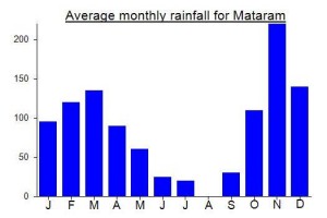
Local Average Monthly Rainfall (mm):
Location
Click on the blue arrow ![]() (top right) to see your current location on the map
(top right) to see your current location on the map
Had a bit of time to kill before heading to Sumbawa so I rode a scooter from Bali to Lombok (Lembar) then north through Sengiggi to Sembalun Bumbung. Having your own transport is a real win, as friends of mine just went from Bangsal Harbour (Gil Air jump off point) to Sembalun Bumbung and they couldn’t get it any cheaper than 750 000IDR. I went in August (2023) and the road from Bangsal to around Bayan was abhorrent, serious road works every couple of kilometers. I stayed in Sembalun Bumbung as suggested (Bukik Asri, 220 000IDR) as it was close to the ‘Sempana Base Camp’ which was trickier to find than I imagined! Anyway, I went the day before so I could be well planned and on the road early, bought a ticket, 30 000IDR with the usual confusion and mayhem that is often connected with activities in Indonesia. Next day I got a lift from ‘Base Camp’, a couple of K’s down the road, to the little bridge on the left and started my hike. On the way back I walked from the bridge; it’s a pleasant and mostly shaded stroll that enabled me to stop and chat to the local farmers as they went about their day. Once over the bridge, I basically followed my nose until I got to a bamboo gate and a path that went left…climb OVER the gate, don’t go left. From there I walked uphill…oh, I was solo as there were no guides available and I was travelling for a couple of months on my own. As described by others, the trail heads through farming country, then follows the ridgeline then goes quite steeply uphill (I’m pretty unfit) through Pos 1 and 2, up a couple of bamboo ladders that have seen much better days (though still serviceable) and up and up. I reckon I was about 150, 200 M up from pos 2 when the cloud rolled in and my dodgy right knee started to give way and so that, as they say, is ‘all she wrote’ and I trudged back down. The views from where I was, looking across the valley to Rinjani and down to Sembalun Bumbung and Sembalun Lawang were absolutely sensational. If I hadn’t been solo, and had the good sense to bring the camping gear I had, then I would have persevered. Sempana was much harder than I thought it was going to be but I had a marvelous hike; the solitude was awesome.
I had long wondered about the ‘eastern hills’ of Lombok, whether they were just an extension of Rinjani itself or might be worth hiking in their own right. Well, I’d definitely say the latter now, after having hiked Sempana a few days ago.
It is not easy getting to Sembalun from the airport at present – no proper public transport, a supposed minibus option but with so few tourists they don’t appear to actually operate very often. I looked into car hire but everyone was asking for an extra 100 for taking the car to the airport and another 100 for picking it up at the end which seems incredibly excessive and cartel-esque. So it ended up being only marginally more expensive to simply hire a car and driver, 400 each way.
Last time I was up at Sembalun for a Rinjani trek, we definitely used the north route via Sengigi. Now it seems that the southern approach is used – shorter and faster but quite windy, up via Kebun Raya Lemor. Only 2 and a half hours. Lots of local hikers with backpacks on motorbikes, and there are now tens of camping locations on the lower mountains and grassy savanna areas.
Stayed at Paer Doe homestay as it was close to the Sempana trailhead. Friendly and good food available, but there are several Paer Does dotted around – the homestay one definitely comes recommended as a simple place to stay in Sembalun Bumbung. After only 18 months of very few foreigners, I was being stared at by the local kids as if an alien had landed. Amazing in such a place as Sembalun which is in normal times a place where foreigners stroll around every single day.
A guide for Gn Sempana is 250k a day, so 250 assuming you are not camping up there. My guide wasn’t happy when I asked him about ‘Bukit Sempana’. It’s a mountain, not a hill, he replied! Funny how in Kalimantan many ‘hills’ take several days to reach the top of! If starting in the dark you definitely need a guide, and as usual route-finding in the kebun is not that easy but once onto the ridge you can’t go wrong.
The views up on the ridge are spectacular first thing in the morning. Absolutely brilliant. A worthy addition to the list of Spesials. GPS reading at the top was around 2331m or so, so 2329m is perfectly reasonable. We set off at 3am and I was back down by 10am and then off to the airport for a flight to Sumbawa to hike Olet Sangenges – 2 mountains in 2 days!