
Facts
- Elevation: 2,493 m (8,179 ft)
- Prominence: 1,541 m
- Ribu category:
 Tinggi Sedang
 - Province:
 Bengkulu
 - Coordinates: -3.3920, 102.3425
- Rating:

 (2 votes) Add your rating
 Loading...
 - Other names: The highest peak is labelled Gunung Hulupalik on the Bakosurtanal map.
- World Ribus ID: 69079
Photos


Bagging It!
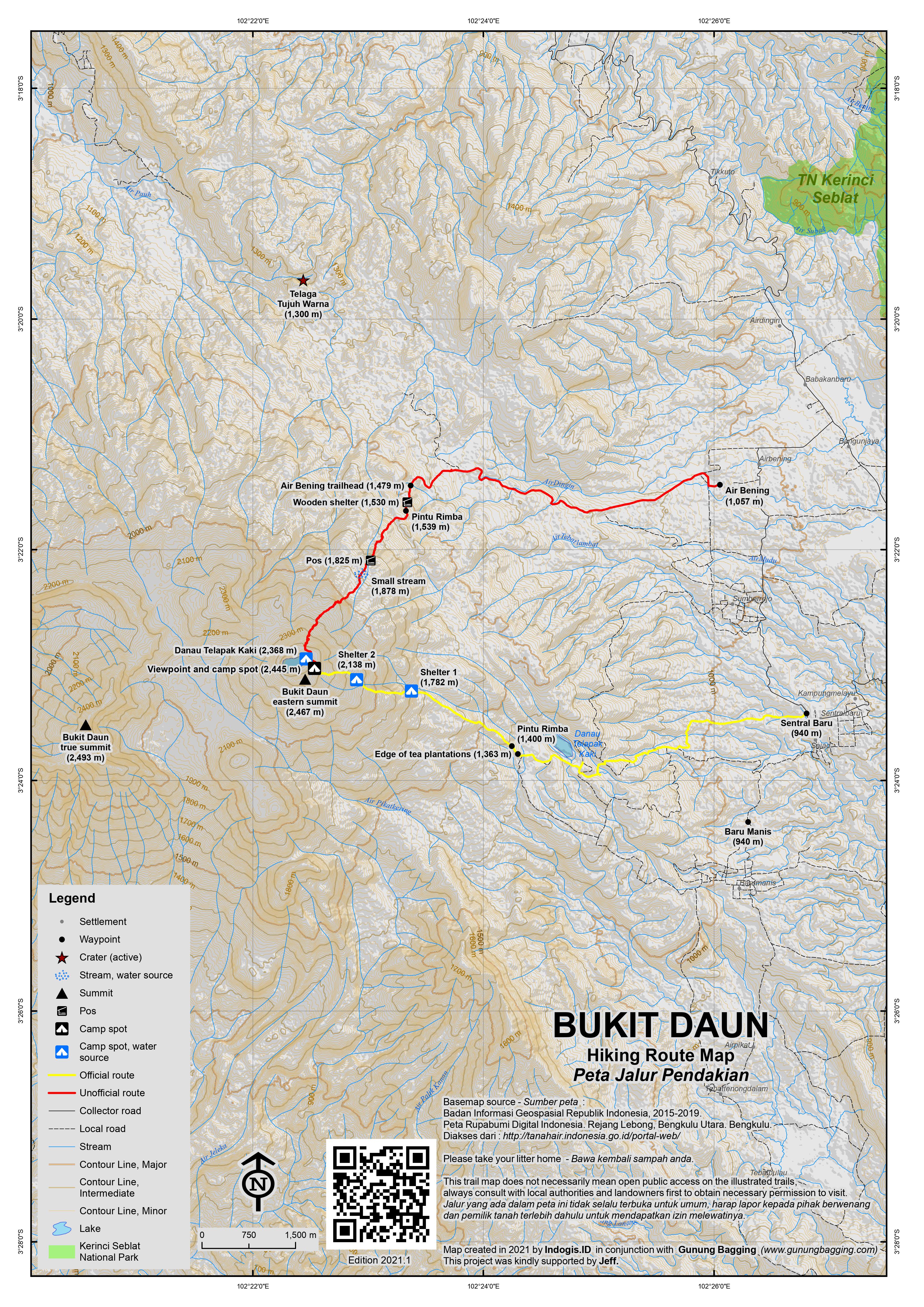
Gunung or Bukit Daun is one of the highest and most prominent peaks in the southern half of the island of Sumatra and in recent years a hike to the lake near the top has been growing in popularity with local hikers. The lower slopes of the mountain are covered in coffee and tea plantations and there are some small, coloured crater lakes on the north-eastern side which could be visited if you have an extra day in the area.
Bengkulu is the best airport to fly to, as it has more flights scheduled from Jakarta than the alternative Lubuk Linggau. The small city also has a few historical sights very much worth visiting including the British Graveyard (Makam Inggris) and Fort Marlborough (Benteng Marlborough) from where you can actually see Bukit Daun in the distance in clear, early morning weather.
From Bengkulu it’s around 2 hours or a little more to reach Curup, which is the best base with hotels and is a little cooler up at 600 metes above sea level. The incredibly windy road through the jungle is one of the best spots in Indonesia to see the famous Rafflesia, and occasionally there are signs at the side of the road to say that there is one in bloom a short distance away.
From Curup, it is around 40 minutes to the three villages where you can start your trek or find ojeks to the edge of the forest, namely – from south to north – Baru Manis (940m), Sentral Baru (940m) and Air Bening (1,057m). In 2021, there are two trails up Bukit Daun from these villages, the official one via the tea plantations above Baru Manis and Sentral Baru, or an unofficial and overgrown local hunters’ path beyond Air Bening. The former is very much recommended.
From the east – Baru Manis or Sentral Baru route
From the villages you can either find ojeks to take you up through the PT Agrotea Bukit Daun tea plantations to Pintu Rimba (1,400m) requiring around 45 minutes, or else walk the long way up through the plantation tracks, which requires around 2 hours and has lots of junctions with no signs. An experienced guide is very much recommended.
From Pintu Rimba, which is the forest entrance, the trail leads up the side of the mountain, gently at first but getting progressively steeper. There are two main camp spots on the trail, both of which are close to streams for water (Shelter 1 at 1,782m and Shelter 2 at 2,138m) although neither has an actual shelter building. There are leeches in the forest here, but tend to be fairly small in size and not too great in number compared to other Sumatran mountains.
The rim of the caldera (2,435m) which contains the lake is reached after about 5 hours from Pintu Rimba. Take a right to the viewpoint and lake or a left to the highest point of this eastern part of the Bukit Daun mountain range. Assuming you head right (north) it is just two minutes to the viewpoint (2,445m) from a few grand toppled-over trees which appear to still be alive and also create a fairly sheltered spot at which to camp. Indeed, this is the best place for views and also the best place to camp. It is also what most hikers regard as the summit, with various signs left here.
Continuing north, the trail drops down to the lake (2,368m), reached after just ten minutes or so. On the Bakosurtanal map this is simply labelled as Danau Bukit Daun, but is known locally as Danau Telapak Kaki (‘foot sole lake’) because of its shape.
This very pleasant highland lake is about 350 metres wide and was presumably formed in an old volcanic crater though no eruptions are known to have occurred in recent times. The local hikers who visit Bukit Daun tend to camp here, and sadly there is a fair amount of plastic left behind in what is a sparsely-populated, protected forest area. It is also rather muddy, which is why the viewpoint above is proobably the better place to camp.
Peak baggers may be wondering where the highest point of the rim above the lake actually is. Well, according to the Bakosurtanal map, the highest point of the northern side of the rim is 2,440m and the southern side of the rim is a little higher at 2,467m. Indeed, if you go back to the trail junction near the viewpoint and continue for five minutes along the rim as it leads you south-west, you will reach a small clearing in the mossy forest. This is the highest point of this eastern side of the Bukit Daun mountain range but has no hiking club signs in 2021. After this small clearing, the ridge leads downwards, though there is still a rarely-used path with red tags and a reasonable viewpoint over the lake just two minutes beyond the clearing.
However, the true summit of the entire range (known as Gunung Hulupalik and just 26 metres higher at 2,493m!) is a considerable distance away to the west, lying over 3 kilometres from the clearing, as the bird flies. There are no reports of any groups having reached the true summit, and no information on a trail over there via what looks like difficult terrain on the map. It may well turn out that an approach from the west near Air Terjun Palak Siring Kemumu would be easier, rather than having to drop down into the large, remote and potentially swampy valley between the two highest peaks of the range.
Assuming you have chosen to camp at the viewpoint, watch out for a considerable array of birdlife, especially at dawn and dusk. Also watch out for the tiny biting flies, not dissimilar to Scottish midges! An anti-insect cream or spray is recommended!
Most hikers can be down at Pintu Rimba in just over 3 hours, but unless you have ojeks arranged to meet you there, it is another 2 hours through the plantation to Baru Manis or Sentral Baru.
From the north or north-east – Air Bening route
Given the considerable distance to Pintu Rimba from the villages, some locals may suggest you use the PT Geothermal Energi track which snakes up the northern side of of the mountain from Air Bening. Indeed, there is a trail in the forest here used by local hunters but it is not official and is so rarely used that it doesn’t take any less time than the other one anyway and is not recommended at present.
There are no proper Pos or signs, and the informal trail leads from the geothermal track (1,479m) via a wooden shelter (1,530m) before entering forest (1,539m). Next is a spot or informal Pos (1,825m) that was once used for camping just prior to a small stream (1,878m) which may only be small pools of stagnant water and may not be reliable during the later part of the dry season. Siamang calls are often heard here, and a little higher up you may encounter pitcher plants on the forest floor.
The northern part of the rim (2,424m) is finally reached at which point you can find a way down to the edge of the lake and meet up with the official trail up from the tea plantation. Most hikers will need 5-6 hours to reach the lake from the geothermal track near Air Bening.
The main points of interest on the northern side of the mountain are actually the numerous small, coloured crater pools (Telaga Tujuh Warna, 1,300m) dotted around the forest landscape. As the name suggests, there are supposedly seven in all, including white, red and blue. However, these are not passed on the summit trail as they are situated to the north of the geothermal access track. Therefore they must be visited separately from Air Bening where you can find local ojeks. Ideally you need a separate day to visit them.
Bagging information by Dan Quinn (June 2021)
Trail Map
For a high quality PDF version of this and other trail maps, please download from our Trail Maps page.
Practicalities
- Getting there: Fly to Bengkulu or Lubuk Linggau and head up to Curup (approximately two hours away). Then on to the tea plantations at Desa Sentral Baru or Baru Manis where the trail to the lake and eastern peak begins.
- Guides and GPS Tracks: Want a PDF version for your phone? Looking for a guide? Need GPS tracks and waypoints? Bukit Daun information pack can be downloaded here.
- Permits: Register with the village head in Sentral Baru or Baru Manis. In 2021, Rp25,000 per group.
- Water sources: Available at Shelter 1 (1,782m), Shelter 2 (2,138m) and at the lake (2,368m) but best boiled before use.
- We recommend Safety Wing as travel insurance for overseas travellers and tourists hiking up to elevations not exceeding 4500 metres.
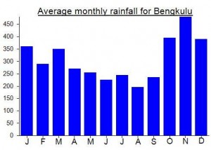
Local Average Monthly Rainfall (mm):
Location
Click on the blue arrow ![]() (top right) to see your current location on the map
(top right) to see your current location on the map
Good afternoon Dan, we just got back from Bukit Daun (the crater lake, not the real summit / Hulu Palik). Seven of us went up from Barumanis and camped at the rim among the fallen trees as you had recommended. Very nice forest, nobody else on the entire mountain, a real pleasure. However, very bad experience with porters, and especially their organizer (Redhy Sinamkulo) – a complete crook – the first time I have to say something like this about a local guide.
Hey Christian, sorry your experience with your guide was no good. We actually host trips now to the Bukit Daun summit along with a ton of other locations. You can see our reviews on TripAdvisor. We run quality treks and all our guides and porters are amazing people. We even have a little pack-raft we take up to the lake on Bukit Daun to paddle around! Anyway, drop us a line if you want to do any other adventures in Bengkulu area (or even tackle Mt Dempo in nearby Pagar Alam).
PS – Here’s our Bukit Daun Summit page: https://www.wildsumatratours.com/bukitdaunsummit/
Joshua
information about the highest peak in your map is very wrong and misleading, the highest peak is Mount Hulu Palik 2493 masl, the peak with the lake is the peak of the leaf mountain, if you source on the RBI map it is very clear that the topomini in the RBI Bakosurtanal map
Jack rimbawan
MountainGuide
Thanks for your comment. The write-up includes two references to Hulu Palik. As for the map, it depends what you consider the name of the entire range to be, as the map covers the entire range. If the range is known as Bukit / Gunung Daun, as seems to be the case, then distinguishing between an eastern peak that is commonly-hiked, and a distant western peak that is rarely – if ever – visited seems reasonable.
Nice to know Hulu Palik is considered the official name of the higher, western, peak. there is very little information on this peak available and no clear evidence of any hiking groups having reached the top. If they did so, it would presumably be done from the regular Bukit Daun hiking route, rather than from a new direction.
If Hulu Palik was better-known and with a trail, then perhaps the map itself would be titled ‘Gunung Hulu Palik’ with a lower eastern top – Bukit Daun. But for now, most visitors to this range will know it as Bukit Daun. Perhaps the map will get an update later with Hulu Palik written on the text label for the 2493m peak.
I had been putting off a trek up Bukit Daun, mainly because I knew the true highest peak was a long way from the lake and eastern peak and there was no information on anyone having visited it. Well, that remains the case, but it’s a decent trek despite not going anywhere near the actual true summit.
The first Bengkulu-based mapala hiker I spoke to was unavailable, and the second suggested the ridiculous sum of 3.2 juta. In actual fact it is not difficult getting to the villages at the base of the mountain but it is important to arrange a local guide in advance if possible, so they are ready when you arrive. You will have to take your own camping gear. You can WhatsApp the Kepala Desa at Sentral Baru on this number: 085256088909
From Bengkulu there are ‘travels’, shared cars, up to Curup several times a day and back down, typically Rp100,000 a seat and leaving morning, lunchtime and late afternoon. Try this number: 082180081554
I spent a night in Curup. The Grab app is available there for transport and food, but there are very few drivers, with none of my orders being accepted. So traditional ojeks remain the norm and are quite easy to find.
I didn’t have enough time to visit the coloured pools, as it really requires a separate trek, though ojeks over bumpy terrain can get you fairly close to them. They look pretty impressive on Google Maps.
There was nobody else up on Bukit Daun on a Saturday night, but I have already seen plans for a trip there by local hikers next weekend, in order to clean up the rubbish left by other hikers. So on a weekend it is probably 50-50 as to whether you will meet any other groups up there.
The highest reading I got on my GPS near the clearing I mention above was 2473m, which is a pretty good fit with the 2467m on the Bakosurtanal map.
It would be great to hear from anyone who has reached the true summit way over to the west! It would probably require a lengthy expedition.
I spent a night in Bengkulu afterwards, mainly because of the flight schedule being reduced compared to pre-covid times when there were early evening flights and this trip may have just about have been possible in a weekend if you chartered a car up to Curup and back down again.
I have always enjoyed wandering around Bengkulu (AKA Bencoolen) – the long beach where you can sip on a kelapa muda and stare at the ocean, the British graveyard whose oldest ‘resident’ is the evocatively-named Stokeham Donston (passed away at Fort Marlborough in 1775), and of course the fort itself.
Getting back was a bit of a hassle. The airport has Genose which is cheap and ought to be a simple process, but you need to download an app, join various queues, zap QR codes, validate your certificate and so on. It seems like almost no thought has been given to how the elderly might do all this, especially those without a smartphone, or how simplifying things may actually be of benefit to everyone. The announcement chime/jingle thing at Bengkulu airport is microtonal – beautiful, alien-sounding, at least to these ears. I cannot even comprehend what kind of keyboard it was recorded on! And there’s some rather good local artworks on display at present.
The flight to Halim was held in hold pattern for 6 loops above Bekasi due to the military apparently, so a one-hour flight ended up being close to two hours! Great trip overall though.
The Bengkulu-based Wild Sumatra Tours offer a multi-day trek on the lower slopes of Bukit Daun, and there could be a summit trail opened this year…..
“Currently we only have a trek to Kawa 7 Warna (7 colored pools) on the lower slopes of Bukit Daun. However, we are planning some surveys to Daun over the next 1-2 months to map the summit and eventually offer it on our website as a trek. We hope to have this as an option by April this year. I can let you know once we are ready to receive guests for the Bukit Daun summit trek. We are also hoping to combine the summit and 7 colored pools trek into one trek probably lasting about 4-5 days. We also have plans to survey Mt Seblat later this year. We are working with TNKS to open it up as an eco-tourism option. More later…”
http://www.wildsumatra.com/
Hey Dan,
We have been running treks there for a few years now. My sons are actually in the pictures on our website, one in the pack-raft and one overlooking the lake from the summit. Btw, if people do come on their own then they MUST have a local guide because it’s very easy to get lost (and that’s tiger country). Our guides get called out every so often to help locate a local person lost in the jungles. Also, there is a permit fee that you should pay our you might get in trouble. Let me know if you guys at gunungbagging.com have any other questions about Daun or the surrounding Bengkulu area.
https://www.wildsumatratours.com/bukitdaunsummit/
Joshua
Thanks for the comment Joshua. The permit process in much of Indonesia is in need of great improvements, especially outside of Java. It is great that you are taking groups there but your prices are simply not attractive to anyone who has even the most basic understanding of the Indonesian language and a bit of experience in the country.
Hi Gunungbagger
I am interested in this mountain and am a little surprised it hasn’t had much attention. My attention was drawn to it by the recent spate of fatal land slides in the area.
Pls let me know if there are any plans to climb in the next year or so.
Regards
JOhn Rawkins
salam rimba sobat…