Facts
- Elevation: 1,964 m (6,444 ft)
- Prominence: 990 m
- Ribu category: Spesial
- Province: Lampung
- Google Earth: kml
- Rating:
- Other names: none
Photos
Bagging It!
Unknown at present. According to the Bakosurtanal map, the summit features the triangulation pillar P.76.
Practicalities
- Getting there: There are regular buses from Bandar Lampung (Rajabasa terminal) to Liwa (where you can change) and one bus per day direct to Ranau. There is even a bus all the way from Jakarta. There are also plenty of buses from Palembang via Batu Raja. If driving, if can take from between 6 to 8 hours to reach Danau Ranau from both Palembang and Bandar Lampung.
- Accommodation: Wisma PUSRI overlooking Danau Ranau lake is a nice place to stay. You will have to pay two fees of approximately Rp5,000 to enter the complex. Otherwise there are one or two losmen in Kota Batu or, further away, Banding Agung. Liwa or Krui mightt be better choices, depending on the starting point.
- Permits: Unknown.
- Water sources: Unknown.
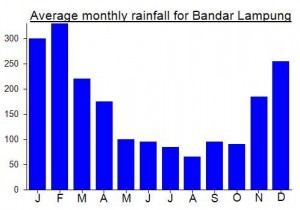
Local Average Monthly Rainfall (mm):


Hi Dan
I am keen to try and climb Gunung Pugung..Lampungdo you have.any idea about a local guide in the Area?
Cheers Lawrence
Been there, but not the peak. You can start climbing fro Sukabanjar. Ask around the village for local guide, perhaps some ex-illegal logger would agree to guide you there. The trail is a narrow ridge to the top. Water is not available when you already on the ridge towards the peak. A friend of mine has to squeeze water from mosses for drinking.