
Facts
- Elevation: 1,949 m (6,394 ft)
- Prominence: 1,949 m
- Ribu category:
 Kurang Tinggi
 - Province:
 Nusa Tenggara Barat
 - Coordinates: -8.1959, 119.0698
- Rating:

 (3 votes) Add your rating
 Loading...
 - Other names: none
- Eruptions: 1512, 1715, 1821, 1860, 1911-12, 1927, 1953-58, 1964, 1966, 1985, 1997, 2009, 2014, 2017-18
- World Ribus ID: 69039
Photos


Bagging It!
Gunung Sangeang (or Sangeang Api) is a very active island volcano, just off the north coast of Sumbawa. The island is 13km wide and getting over there from ports in Sumbawa should not be too difficult.
There are two main peaks with about 2 kilometres between them, which are named on old topographic maps as Doro Api (1,949m) in the north and Doro Mantoi (1,795m) in the south, but on the Bakosurtanal map the same peaks are name Doro Delatoi (1,909m) and Doro Monggo (1,783m).
Practicalities
- Getting there: Several flights per day to Bima, Sumbawa from Denpasar (Bali) and Lombok.
- Permits: Take a photocopy of your passport photo page to give to the village chief.
- Water sources: Unknown – assume none
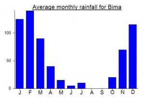
Local Average Monthly Rainfall (mm):
Location
Click on the blue arrow ![]() (top right) to see your current location on the map
(top right) to see your current location on the map
Origins and Meaning
‘Sangeang’ means spirits. In Bali, there is the Sanghyang Dance – a trance dance in which a teenage girl is thought to be in contact with the spirits, and an orang sangiang means a ‘spiritual healer’ in Central Kalimantan. “Gunung Sangeang” is basically “Mountain of Spirits”.
Hi,
I want to climb sangean api in january 2026. Has anyone done it recently ? How was it ?
Thanks
Hey just wanted to give an Update
unfortunitly i did not get a chance to go up the mountain still wanted to reply though. I asked around with some local work kolleges of mine and they said its bad luck for a foreigner to go up that mountain and that it was haunted (some singing voices). Went to Vera (sumbawa island gateway to the island) there I was told that I can go to the island but no one seemed too eager to go up the mountain.
best of luck, I am still planning on going (hopefully september) as the legend has me intrigued.
Hello
I am new here.
I want to hike up Sangeang island. From what I have read in this formum no one has actually really been to the top recently. Does anyone konw if it is possible this time of year (March April), also is it necessary to have a guide or can it be done without? I was thinking it could be done without as there isn’t much of a path to follow anyway and I am guessing it would be a 1.5 day hike.
Is there anyone here that might be interested in joining me (26 male)?
Hi Lukas,
It is definitely possible from April to October but you would be mad to go without a guide. I imagine you will need 2 nights on the island. There is very little shade on the island and few or no water sources. So it needs a lot of planning. I’d love to have a go but currently live in the UK.
Dan
I’m going to have a crack July ’23 so any up to date information you have before I go would be greatly appreciated. Cheers
Hi ! I am interested to prepare a little expedition there. I now live in Australia and come to Indo to climb active volcanoes 1/2 times per year. Please contact me at pascastel (at) gmail.com . Cheers!
Just uploaded my hiking Sangeang Api video.
https://youtu.be/kAozXyGCVXI
I checked out Sangeang Api on June 8 & 9, 2016 with four guys from Sangeang Darat. The vertical true summit cone is impossible to reach.
Pictures can be viewed at FB: Gunung Sangeang Api.
Hi paulina, i am keen in checking out the sangeang api volcano. Would be glad if you could share some information about your trekking experience. thanks !
Huge eruption at Sangeang Api at the end of May. Some good pictures here….
http://www.dailymail.co.uk/news/article-2644253/Incredible-moment-huge-volcano-erupts-Indonesia-sending-ash-spewing-thousands-feet-sky.html
Hello there
Sorry to say my ambition to climb Sangeang is still that – an ambition. So you have been on the island and tried. I’d like to hear more. From Google Earth images there appear to be a couple of possible acess routes. Did you have a guide? I know the island has been uninhabited for years but was wondering if the previous inhabitants still go there to plant anything on their former lands. Ant info most appreciated.
Steve
I want to climb Sangeang this year so watch this space
Just wondering if you climbed Sangeang so how is it was? I tried to climb it too, but unsuccessfully in 2008, when I almost died when gone astray and wade through the impenetrable thicket. So I want to revenge this mountain and plan to conquer it again