Facts
- Elevation: 2,543 m (8,343 ft)
- Prominence: 1,273 m
- Ribu category: Tinggi Sedang
- Province: Jambi
- Google Earth: kml
- Rating:
- Other names: Rayo
Photos
Bagging It!
Gunung Raya lies above the large Kerinci lake in Jambi province – a considerable distance from Gunung Kerinci but visible from the higher slopes of Gunung Kerinci. The road around the western side of Kerinci lake offers good views of the secondary peak Bukit Bemban (2,100m) before a glance back from your vehicle as it passes rivers and rice paddies will afford excellent views of Gunung Raya itself hiding behind. Some maps mistakenly name this mountain Gn Kerongsong. Another mountain in the area which is climbed is Bukit Kunyit which is about 2115m high and close to the beautiful translucent blue lake of Danau Kaco.
Local Accommodation
Practicalities
- Getting there: There are regular flights to Padang’s International airport from Indonesia and neighbouring countries. It is then a long 6-8 hours drive to the starting point. There is public transport and ‘travel cars’ for which you share a car with others but it will take you most of a day to reach Sunggai Penuh. Alternatively, fly direct to Kerinci Airport in a turboprop from Jambi – 10kg baggage limit and one flight per day in 2019.
- Permits: Unknown
- Water sources: Unknown
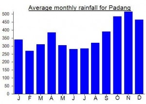
Local Average Monthly Rainfall (mm):
Location
Origins and Meaning
‘Great’, ‘big’ or ‘large’ mountain in Indonesian.


 (3 votes) Add your rating

Jika anda tertarik ke gunung raya, silahkan email ke sandikas455@gmail.com
Lihat lah vidio ini dari puncak gunung raya
https://www.instagram.com/p/B1bhczglGS-/?igshid=pe143mqqlqp2
You might want to try the Avail Outlet outdoor shop in Sungai Penuh to find a guide/porter….
0852 66404844 or 0812 20095145. Apparently nearby Gunung Kunyit is also worthwhile – sounds like there is a small crater there and also close to a truly beautiful translucent blue lake called Danau Kaco…
Easy to get to from Sungaipenuh in Kerinci – allow three days return for the climb, excellent forest but watch misleading ridge trails ..excellent moss forests and fantastic views. You can see to Bangko more than 100km east on a clear day and to the ocean to the west. Remember to buy a ticket to enter the national park from Park HQ in Sungaipenuh