
Facts
- Elevation: 1,538 m (5,046 ft)
- Prominence: 980 m
- Peak category:
 Spesial
 - Region:
 Peninsular Malaysia
 - Malaysian state: Kelantan
- Range: Banjaran Tahan
- Coordinates: 4.8458, 102.0633
- Rating:
 (Bagged it? Be the first to rate it)
 Loading...
Photos

Bagging It!
Gunung Rabong lies to the north of Gunung Tahan, and remains fairly unknown despite having some great views from the top. The trek is usually completed in two days, with a night spent camping at Camp Taman below the peak. Some groups will take longer, especially if starting later in the day.
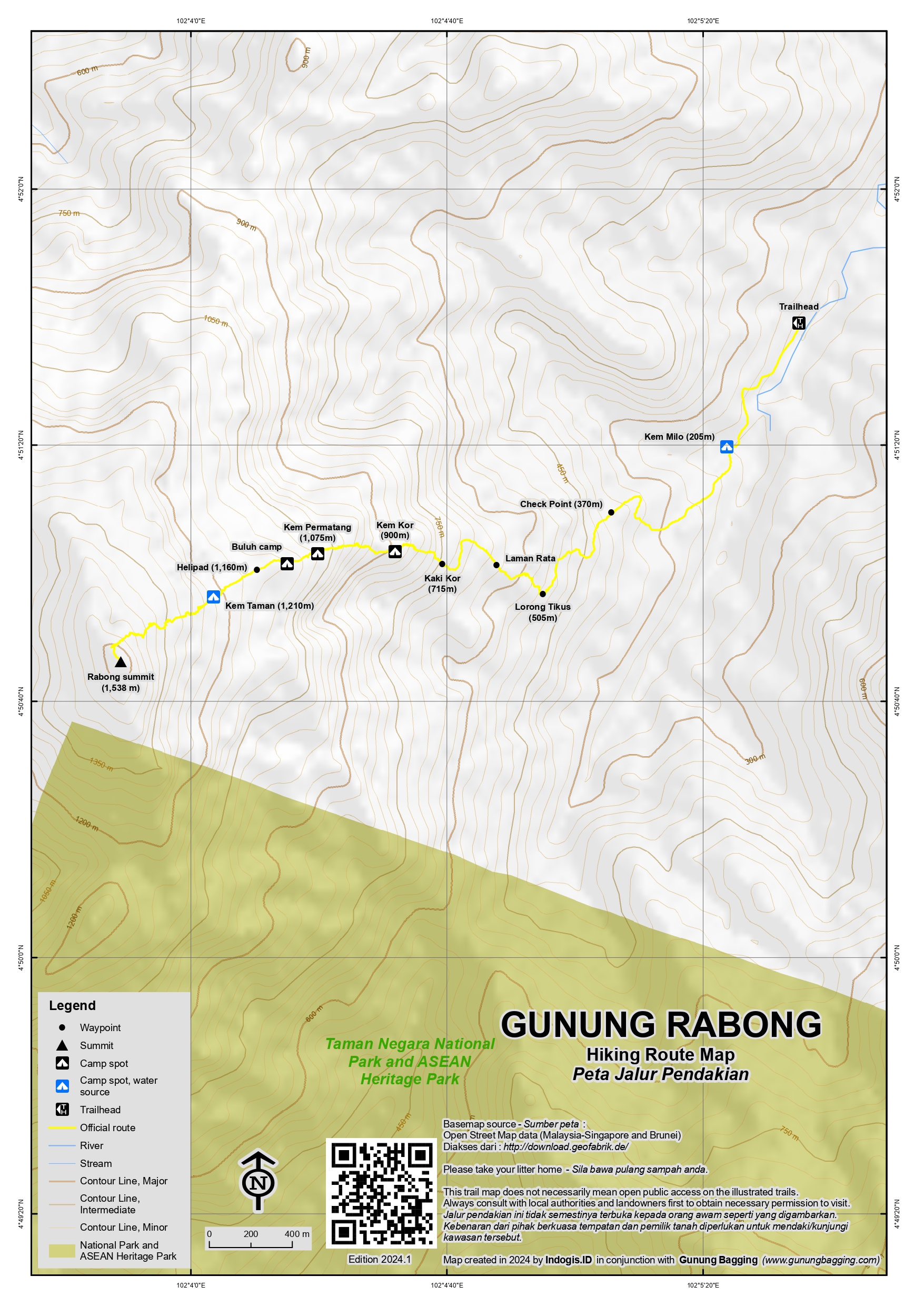
The obvious base is the nearby town of Gua Musang which has a railway station. There are actually two possible trailheads, namely Felda Perasu and Kampung Air Manis, with most hikers opting for Felda Perasu with the trailhead accessed via a 45-minute drive through oil palm plantations and through rivers and then along a logging road. The proper trail starts at Camp Milo and leads via Lorong Tikus, Kaki Kor, Camp Kor, Camp Permatang, Camp Buluh, Helipad and finally Camp Taman (at approximately 1,200 metres above sea level).
Camp Taman is the ideal spot to camp at, with a water source and flat areas.
From the trailhead to Camp Taman takes around six hours with another one or two hours from Camp Taman to the summit. Therefore a day-trek could theoretically just about be accomplished in one long day of twelve hours or more, but you may miss the best views from the peak over to the Gunung Tahan range further south. The best views are usually first thing in the morning at sunrise. Naturally, Gunung Rabong can also be seen from the much more popular Gunung Tahan trek, appearing as a sharp pyramid rising over lower surrounding mountains.
In 2024, the popularity of the Gunung Rabong hike has decreased, with only one or two groups having completed the trek since the start of the year. Finding a guide is currently challenging, though hikers are not allowed to visit Gunung Rabong without a guide. It is not clear the exact cause of this, but a local news report in July 2024 detailed tiger sightings in the plantations near Gua Musang, so that is one possible explanation to consider. Apparently the tiger is preying on livestock, perhaps due to the African swine fever epidemic having decimated the local wild pig population, one of the normal food sources for Malay tigers in the forests.
It is hoped that this situation improves in the near future and that Gunung Rabong is, once again, possible to visit without considerable trouble and concern.
Trail Map
For a high quality PDF version of this and other trail maps, please download from our Trail Maps page.
Practicalities
- Getting there: For Malaysian domestic flights and flights within Southeast Asia, for example to Kuala Lumpur, we recommend Baolau.
- Permits: coming soon.
- Water sources: The last water source is at Camp Taman (1,200m).
- We recommend Safety Wing as travel insurance for overseas travellers and tourists hiking up to elevations not exceeding 4500 metres.
Local Average Monthly Rainfall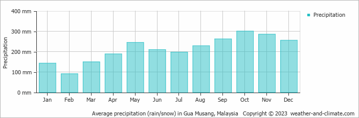
Location
Click on the blue arrow ![]() (top right) to see your current location on the map
(top right) to see your current location on the map
Well, three of us were ready to do a 2-day hike of Gunung Rabong in July. Slowly, three became two, and then two became one. That one was me, naturally! And then I was informed that there were no guides willing or able to hike Gunung Rabong. The reason why was not perfectly clear. Maybe a weekend would have been easier. Or maybe it’s because of the new rules that only permit guides from a state to be a guide in that state, meaning that if there are no Kelantan guides available for Gunung Rabong then you cannot simply find a guide from Perak to lead you, even if he or she knows the trail well. This is a serious disadvantage to the current situation with guides and permits.
However, it may well have been more to do with the presence of a tiger near Gua Musang. Who would want to hike after reading this? https://www.nst.com.my/news/nation/2023/07/932207/tiger-preying-livestock-felda-perasu
And so I spent a couple of days relaxing in Gua Musang. I was really looking forward to a pizza at Pizza Hut but it was ‘closed for renovation’. Later in Gerik, the same story. Reading between the lines, or rather completing ignoring the lines on the renovation notice, it seems to have been more to do with Israel vs Palestine and the idea that Pizza Hut has links to or supports Israel.
Certainly the Palestinian flags are out in force in the Malaysian mountains at present. On my day off at Gua Musang I decided to hike up Gua Musang Peak (260m), a brilliant little excursion through a cave system and up onto a grand viewpoint with a Palestinian flag overlooking Gua Musang train station. This only takes an hour or two, depending on how long you enjoy the view. I took a guide (and several of his friends) from Muse Ecopark (134m) to be on the safe side – best contact them a few days in advance.
Perhaps Rabong will happen in 2025…
Gua Musang is the obvious base for Gunung Rabong, which can be seen clearly from the higher slopes of Gunung Tahan and also the main road north to Gua Musang, but not many folk know about the short hour-long hike to Gua Musang Peak. I didn’t do it as I wanted a proper rest prior to our planned Gunung Chamah hike, but my two friends did. The trail starts near the train station, passes beyond a sort of shanty town area before leading via a very narrow passage into an impressive cave network. A torch is required. The peak is only around 250m high but offers good views over Gua Musang.
See here for more info from Rob Woodall: https://www.peakbagger.com/climber/ascent.aspx?aid=1947847