
Facts
- Elevation: 2,103 m (6,900 ft)
- Prominence: 917 m
- Peak category:
 Spesial
 - Region:
 Peninsular Malaysia
 - Malaysian state: Perak
- Range: Banjaran Titiwangsa / Main Range
- Coordinates: 5.0167, 101.4450
- Rating:
 (Bagged it? Be the first to rate it)
 Loading...
Bagging It!
Gunung Gerah (the lowest of the ten main peaks in Peninsular Malaysia over 2,100 metres) is a remote and challenging mountain requiring serious planning and preparation. It was first climbed in 1905. The usual trail starts from the same trailhead as the route to Gunung Ulu Sepat, and Gerah is usually bagged along with two lesser neighbouring tops, namely Gunung Bilah (2,077m) and Gunung Bieh (2,073m).
The trail leads via Camp Sungai Y, Permatang Camp, Mount Bongok, Camp Sungai Agek, Perodua Camp, Sarsi Camp and on to the ridge where the three peaks lie.
Most trekking groups will spread this over 3 or 4 days but the very enthusiastic and super-fit could complete it in 2 days with an early start and a late finish.
Trail Map

For a high quality PDF version of this and other trail maps, please download from our Trail Maps page.
Practicalities
- Getting there: For Malaysian domestic flights and flights within Southeast Asia, for example to Kuala Lumpur, we recommend Baolau.
- Permits: coming soon.
- Water sources: The last decent source is at Camp Perodua, but there are sometimes brownish water pools on the trail between Gerah and Bilah.
- We recommend Safety Wing as travel insurance for overseas travellers and tourists hiking up to elevations not exceeding 4500 metres.
Local Average Monthly Rainfall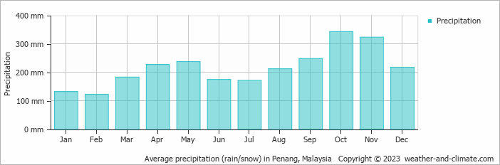
Location
Click on the blue arrow ![]() (top right) to see your current location on the map
(top right) to see your current location on the map