
Facts
- Elevation: 2,367 m (7,766 ft)
- Prominence: 2,367 m
- Ribu category:
 Tinggi Sedang
 - Province:
 Nusa Tenggara Timur
 - Island: Flores
- Coordinates: -8.6517, 120.4480
- Rating:


 (6 votes) Add your rating
 Loading...
 - World Ribus ID: 69024
Photos


Bagging It!
This Ribu is the highest peak on the island of Flores (closely followed by Gunung Inerie). Many other sites incorrectly list Poco Mandasawu as the highest but this is not the case – Mandasawu lies several kilometres to the east and is more than 150 metres lower in elevation. Poco Ngandonalu is very much a peak-bagger’s mountain as although it takes only 3 hours to reach the summit there are very few views from the top and very few people have even heard of the mountain let alone climbed it!
The best approach to the summit is from the southern edge of the large town of Ruteng. There is a right-angle right turn on the narrow road north of the mountain near the Polres Manggarai building. Straight ahead is a wide farm track leading up the hillside and also a left turn along a rough but driveable tarmac road towards an isolated gated house called Villa Ria 1km away which is known well by local people.
The mountain can be climbed from near Villa Ria (1,406m) or straight up the hillside starting on the muddly farm track (1,373m). The latter begins well and curves left before becoming more vague but following a plastic water pipe up the forested hillside. A small river is crossed (1,626m) before a left turn is needed, following another plastic water pipe rising up steep seemingly pathless hillside – requiring some basic scrambling – before the much better path leading up from near Villa Ria is reached! Stay right and make use of your GPS above 1,800m where the trail is not of much use in reaching the very top.
The route all the way from Villa Ria is a lot easier to follow but is steep, muddy and potentially very slippery after rainfall on the lower sections. Both routes are less hiking trails, more woodcutter’s occasionally used paths which seem to vanish and re-appear – especially on the route following the water pipe! There are many piles of wood chippings made by the local loggers. Whichever route you choose, a GPS is more or less essential as there is no trail at the very top and you must bash your way through steep, occasionally dense forest to find the flattish, rarely-visited, unmarked and somewhat undistinguished highest point of Flores island. On the plus side, there are some excellent species of birds living in the forest here and their calls are truly beautiful and peculiar.
Bagging information by Daniel Quinn
Trail Map
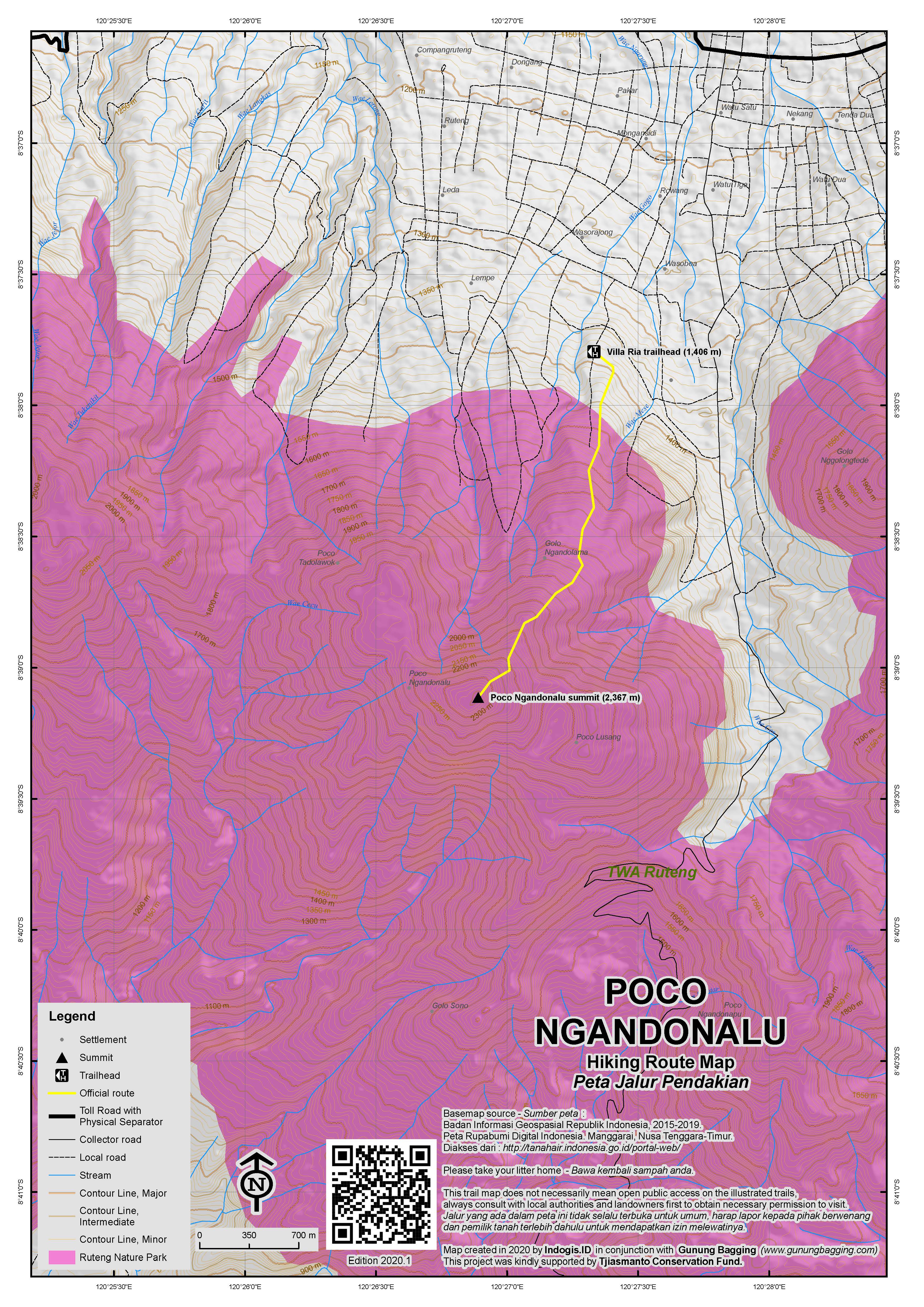
For a high quality PDF version of this and other trail maps, please download from our Trail Maps page.
Practicalities
- Getting there: Ojeks can be arranged in Ruteng for the 15 minute journey.
- Guides and GPS Tracks: Want a PDF version for your phone? Looking for a guide? Need GPS tracks and waypoints? Poco Ngandonalu information pack can be downloaded here.
- Permits: None required but take a photocopy of your passport photo page just incase.
- Water sources: Buy sufficient supplies in Ruteng the night before you hike.
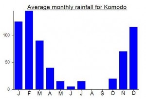
Local Average Monthly Rainfall (mm):
Location
Click on the blue arrow ![]() (top right) to see your current location on the map
(top right) to see your current location on the map
Is Poco Ngandonalu the ribu with the most unpronounceable name? Nobody I met in Ruteng seemed to have heard of it, even though the trailhead is a mere 15 minute ojek ride from the town. Indeed, you could just step out your door at Villa Ria itself, which is now being developed into a hillside resort, with half a dozen bungalows already built, and a café with live music planned.
The guides I managed to recruit for this hike at the last minute, through a cousin of a hotel receptionist from Labuanbajo, turned out to be two schoolboys in uniform, taking a day off from the local tourism high school. And they hadn’t heard of the name Poco Ngandonalu either. However, one of them did say he had climbed the mountain before, once I made clear that it was the one whose trail starts from Villa Ria.
He did a good job during the ascent, starting from one of the numerous woodcutter’s trails to the left of the bungalows and pushing through the thorny bush sections before rediscovering fragments of trails higher up. However, his tendency to dash too far ahead nearly caused disaster during the descent, when he guided us way off the path to the right into a deepening ravine. Luckily, I managed to read my rain-soaked GPS screen in time to spot the error and reorient us in a safer direction. After an extra hour of bashing through brambles and scrambling up muddy gorges we stumbled across a well-trodden path heading down the same ridge that we came up.
We set out from Villa Ria at 09.15 and reached the top by 12.45. The summit was marked by an Indonesian flag and a sign on a tree saying ‘Poco Pajung 2367m’ – so perhaps somebody has decided that a simpler name will make this mountain more memorable. GPS reading was 2361m, but the summit is unmistakeable when you are on it, as the terrain soon drops away on all sides. The first part of the descent went well, as we found a clearly visible trail that we had missed on the way up. It was even marked at some points with string tied to trees, but these petered out below 2000 meters along with the trail itself. If the trail becomes invisible, stay attentive and stay on the ridge! We eventually returned at 16.30 to Villa Ria, where the friendly staff served coffee and tea.
Climbing in mid-December, we experienced intermittent rain showers throughout the day, becoming heavier in the afternoon. A pair of gardening gloves for gripping spiny plants could be helpful; otherwise, expect blood and scars!
I gave my guides Rp200,000 and paid Rp50,000 for an ojek to drop off and pick up at Villa Ria. The Gunung Mas minibus from Labuanbajo to Ruteng gives door-to-door service for Rp120,000. Gunung Mas also runs two minibuses per day – one at 07.00 and one at 14.00 – from Ruteng to Bajawa, also costing Rp120,000.
Interesting to read another Peakbagger report on what is a very infrequently hiked major island highpoint…… https://www.peakbagger.com/climber/ascent.aspx?aid=2219819
Adam Walker writes: “Aside from being an island highpoint and an ultra, this peak has no further redeeming qualities. Even if you manage to follow the overgrown trail the whole way, under current conditions, the tangle-up with brush is fairly serious. The majority of bushes and vines are thorny. All exposed skin will be damaged. I was picking many broken off thorns out of my hands that night at the hotel. One of Petter’s eyes was also slightly injured.”
Their driver in Flores also told them that the current/proposed Bali hiking ban (due to preserving ‘sanctity’ of the peaks) had spread to Lembata and Adonara, so they flew to Kupang for Mutis instead of the planned hikes on the islands east of Flores. It turns out that this rumour really was just a rumour and the ‘ban’ has not spread, not yet anyway.
See http://www.peakbagger.com/climber/ascent.aspx?aid=131198 for Rob Woodall’s account of our recent trip to the top.