
Facts
- Elevation: 913 m (2,995 ft)
- Prominence: 913 m
- Peak category:
 Spesial
 - Province:
 Nusa Tenggara Timur
 - Coordinates: -8.4628, 122.3698
- Rating:
 (Bagged it? Be the first to rate it)
 Loading...
Photos


Bagging It!
This peak is the highest point of a large island in Maumere Bay. The Bakosurtanal map lists the name of the summit at Wolong Ladauneng with a height of 913m. There is a north-eastern peak around 700 metres away with a height of 890m.
Practicalities
-
- Getting there: Fishing or dive boat from Maumere.
- Accommodation: There are several hotels/losmen in Maumere.
- Permits: Unknown
- Water sources: Unknown – take sufficient supplies with you.
Local Average Monthly Rainfall (mm): 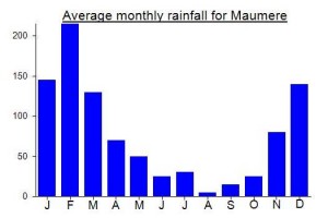
Location
Click on the blue arrow ![]() (top right) to see your current location on the map
(top right) to see your current location on the map
Origins and Meaning
‘Pulau Besar’ simply means ‘big island’.